

Overview
Directions
- Aldons Quarry lies west of the A714 between Pinwherry and Pinmore, south of Girvan. Arrange access with the present landowner before setting out, including where to park and which track or gate to use.
- The published approach uses a roadside layby near the B734/A714 junction, followed by about 200 m south along the A714 to the uphill track. There is no pavement on this road section: take particular care with traffic, and do not use a layby or entrance if it is obstructed or unsuitable.
- The track serves the cottage and small church and climbs past the old limekilns towards the main quarry. Earlier UK Fossils directions describe a wooden gate and a hairpin, with the quarry to the north-west beyond the bend. Confirm the route with the landowner; the older church-side parking advice should not be treated as permission to park there.
- Use an Ordnance Survey map to locate the workings at grid reference NX 198 896. The original guide also gives 55.16769°N, 4.83182°W as a locality reference, not a verified car-park waypoint. The quarry entrance and floor can be very wet, so be prepared to turn back.
Location photographs
Swipe to browse · Select a photograph to enlarge


Fossil Hunting
Aldons is best understood as a limestone and mudstone fossil locality. The principal documented material comes from the Stinchar Limestone Formation and the thin surviving base of the Superstes Mudstone Formation. The older volcanic rock beneath them and the coarse Benan Conglomerate above are important to the geological story, but should not be confused with the main fossil-bearing beds. If the landowner permits collecting, examine loose, already weathered material from a safe position, rather than trying to reopen the quarry faces.
The upper Stinchar beds contain thin, grey, platy limestone and calcareous mudstone with a varied shelly fauna. Trilobites, brachiopods, gastropods, ostracods and echinoderms are documented here. Weathering helps reveal details that may be almost invisible on a fresh, hard surface. Turn small loose pieces in good light and use a hand lens to distinguish shell ornament and repeated biological structure from irregular fractures or mineral veins. Trilobite fragments may show a ridged body segment or part of a head or tail shield; retain a useful partial specimen rather than expecting every find to be complete.
The cobbly and nodular limestone lower in the Stinchar succession has a different character. Many rounded pieces and coatings on rock or shell fragments contain Girvanella, a calcified microbial structure historically described as an alga. These growths contribute to the rock itself, so a nodule is not automatically a complete shell, coral or animal fossil. Their detailed tubular structure is microscopic; a hand specimen can show the fabric without establishing a species identification. Crinoid columnals, shell fragments and small ostracod shells have also been recorded in microscopic examination of Aldons limestone.
The especially diverse trilobite fauna comes from calcareous nodules in the basal Superstes mudstone, historically described on the south-east wall of the main quarry. Only a thin remnant of this formation survives beneath the conglomerate. Large slipped Benan blocks have obscured an important former collecting patch, so old accounts do not guarantee that its fossiliferous nodules are accessible today. The original UK Fossils visit also noted loose material towards the back of the quarry, near a building; vegetation and farm use can change, and a safe permitted search area should be agreed on arrival.
Published work records dozens of Superstes trilobite species. They include Nileus, while Stenoblepharum, Raymondella, Chomatopyge and Miraspis were reported as new records for the Girvan district in the 1976 study. These are records of scientific collections, rather than a list of common present-day finds. The Aldons holotype named Dubhglasina aldonsensis in 1948 was placed in synonymy with D. parvula in a 2002 revision. A single upper-Stinchar cranidium was also assigned to Hemiarges inghami in 1979; the species was principally described from another locality, so this is a rare Aldons record, not an Aldons type specimen.
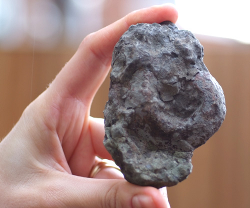
Keep finds from different pieces of matrix separate. Record the position, rock type and whether each piece was loose or demonstrably in situ; do not assign a loose fossil to a particular bed just because it lay below a face. Photograph the specimen and surrounding material with a scale, keep any counterpart, and label the package before leaving. A well-documented fragment can be scientifically useful, especially at a locality with many named type specimens. The photograph retained below has no verified identification in the original records and should not be used as a named fossil reference.
Fossil photographs
Swipe to browse · Select a photograph to enlarge
Discoveries and milestones
A chronological record of significant fossil studies, geological research and scientific milestones associated with Aldons Quarry.
1852 – Early illustration of an Aldons gastropod
A gastropod later named Maclurea sedgwicki was illustrated by McCoy. The specimen is now catalogued as Sedgwick Museum A33941, with an Aldons-area locality; no exact quarry bed or date of collection is recorded.
1882 – First detailed quarry description
Charles Lapworth described the Aldons section and interpreted the contact between the limestone succession and older volcanic rocks as faulted. The contact became an important focus of later geological work.
1899 – Basement contact and fossil fauna reassessed
Peach and Horne proposed that the cover succession rested unconformably on the older rocks. They also recorded Aldons shell and ostracod fossils, including material collected by Mrs Gray, establishing a fuller account of the locality’s fauna.
1924 – Aldons gastropod type named
Longstaff named Maclurea sedgwicki. Sedgwick Museum specimen A33941 is catalogued as its holotype from Aldons, linking the locality to the species’ naming history while leaving the exact bed uncertain.
1948 – Aldons harpetid trilobite described
Lamont named Dubhglasina aldonsensis from material that included the Aldons Superstes holotype, now Hunterian specimen GLAHM A5193. Its taxonomic interpretation was revised in 2002.
1949 – Abandoned limestone workings documented
A Geological Survey limestone assessment described an already abandoned quarry, including a worked face about 30 feet high and the collection of sample SL266. This records the history of the exposed limestone without establishing when quarrying began or ended.
1956 – Microscopic limestone fabric documented
Petrographic study of Aldons sample SL266, thin section S35504, recorded abundant Girvanella tubes, ostracods and crinoid fragments in recrystallised fine-grained limestone, together with quartz and pyrite. The observations revealed detail not readily visible in a hand specimen.
1962 – Brachiopods and the basal contact studied
Alwyn Williams provided a modern account of the Aldons brachiopods and supported an unconformable contact beneath the sedimentary cover. His work contributed to the interpretation of both the fauna and the succession.
1967 – Upper-limestone trilobites described
Ronald Tripp studied the trilobites from the upper Stinchar Limestone. The Aldons assemblage was subsequently summarised as containing 27 species, providing an important comparison with the younger mudstone fauna.
1976 – Basal mudstone trilobite fauna monographed
Tripp’s study devoted to Aldons described 68 species in 47 genera, including 12 new species. It documented the exceptional diversity of the basal Superstes nodules and reported the first Girvan records of Stenoblepharum, Raymondella, Chomatopyge and Miraspis.
1979 – Rare upper-limestone specimen reidentified
One cranidium from the platy upper Stinchar Limestone at Aldons was assigned by Tripp to Hemiarges inghami, previously recorded there only as Hemiarges sp. The holotype and most of the described material came from Minuntion, so the Aldons specimen is a referred occurrence.
1984 – Sedimentation related to fault-controlled fans
Ince interpreted the regional conglomerates as fan deposits and the intervening limestone as a phase of reduced fan activity. Channel erosion and the truncated succession around Aldons helped connect the local contacts with changing sediment supply and basement movement.
1988 – Bedrock survey account published
Stone and Smellie described the two old quarries, the basement unconformity and the variable sedimentary cover around Aldons. Their account highlighted rapid lateral changes and the effect of folding and faulting on the exposures.
1990 – Upper-limestone age investigated with conodonts
Bergström recovered a sparse conodont fauna from an unspecified level in the upper Stinchar Limestone, probably belonging to the Pygodus anserinus Biozone. This added a dating constraint without fixing a zonal boundary within the quarry.
1992 – Detailed succession and channel erosion explained
Ingham set out the quarry’s individual lithological intervals and their thicknesses. He interpreted most of the loss of Superstes mudstone beneath the Benan Conglomerate as channel erosion, while recognising later shearing at the contact.
1993 – Trilobite assemblages reviewed
Tripp reassessed Barr Group trilobites and their distribution. The Aldons Superstes dataset of 3,261 specimens helped characterise an assemblage with a modest Nileus component, supporting the interpretation of deepening water relative to the underlying limestone.
2000 – Scientific importance synthesised
A major geological conservation assessment brought together the quarry’s stratigraphy, fossil diversity and evidence of basement-fault control. Its updated account listed 69 Superstes trilobite species in 52 genera and 21 species with Aldons as their type locality; this publication date is not a date of statutory designation.
2002 – Aldons harpetid name revised
Ebach and McNamara treated Dubhglasina aldonsensis as a junior subjective synonym of D. parvula, illustrating the Aldons holotype. The revision changed the interpretation of a named type specimen without altering its Aldons provenance.
Geology
The two old quarries at Aldons expose part of the sedimentary cover that accumulated after the sea spread across eroded rocks of the Ballantrae Complex. Those basement rocks include altered basalt, traditionally called spilite. A basal conglomerate and pebbly sandstone pass upwards into the Stinchar Limestone, followed by a thin remnant of the Superstes Mudstone and the Benan Conglomerate. The fossil-bearing limestone and mudstone are sedimentary rocks, even though volcanic debris occurs in the underlying and overlying conglomerates.
The succession records a changing marine environment near the Middle to Late Ordovician transition. Regional studies place the Confinis–Stinchar–Superstes interval from the late Darriwilian into the early Sandbian. The pebbly basal deposits at Aldons may span equivalents of the upper Confinis and lower Stinchar succession seen elsewhere, but the correlation is not precise enough to insert a separate, fully established Confinis Formation into the quarry log. Older accounts use Llanvirn, Llandeilo and Caradoc terminology; those historical divisions should not be collapsed into a single numerical age for every rock at the site.
The Stinchar limestone developed when the supply of coarse, fan-derived sediment diminished. Microbial growths coated fragments and helped build the cobbly, nodular carbonate fabric. Higher up, the limestone becomes thinly bedded and interleaved with calcareous mudstone, carrying a richer shelly fauna. The limestone assemblage represents a marine shelf, while changes in the trilobites of the overlying Superstes mudstone indicate deepening water. The strong North American, or Laurentian, affinities of the fauna reflect the position of this part of Scotland on the opposite side of the Iapetus Ocean from what is now England and Wales.
The very small thickness of Superstes mudstone at Aldons is an important feature. Channel erosion before deposition of the Benan Conglomerate removed most of the mudstone here, leaving at most about 1.8 m in the published section. Some later movement also affected the contact, producing sheared mudstone and slickensides. These geological movements are separate from the much later slipping of large conglomerate blocks down the quarry face, which has concealed part of the fossil-bearing exposure.
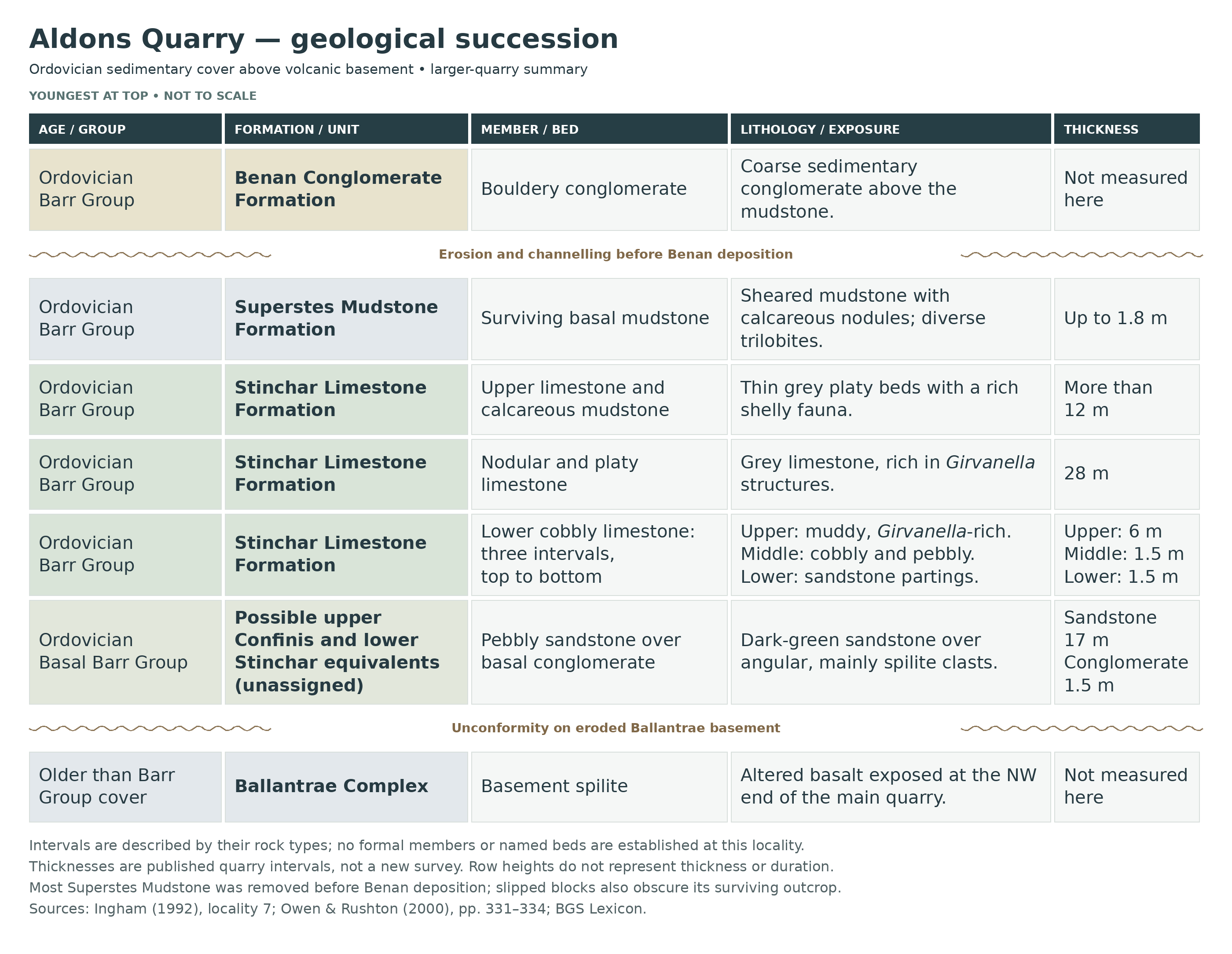
Changes over short distances make Aldons valuable for understanding fault-controlled subsidence. North of the quarry the Benan Conglomerate oversteps the limestone succession and rests on Ballantrae basement; that is a lateral change, not another layer to add to this quarry’s vertical section. The strata are also folded and faulted. The later detailed quarry account describes gentle east-south-easterly dips in the main working and reversed dips with more complex folding in the smaller south-eastern quarry. The chart gives a schematic succession, while the expandable account retains the published bed-scale details and the limits of the correlations.
Detailed geology and bed-by-bed succession
Explore the basement contact, bed-by-bed limestone succession and younger mudstone and conglomerate at Aldons Quarry.
The account below follows the published succession upwards, principally from the north-western basement contact to the south-east wall of the main quarry. Thicknesses are those of historical measured intervals, not a new survey of what is visible today. The descriptive subdivisions are not formal members or named beds. Vegetation, faulting and slipped blocks may interrupt the exposure.
Ballantrae Complex basement and unconformity
The oldest rock at the north-west side of the main quarry is spilite, an altered basalt belonging to the Ballantrae Complex. The overlying sedimentary cover rests unconformably on it: erosion preceded deposition of the younger beds. No local basement thickness is implied, and the basement is not part of the Barr Group.
BARR GROUP
The Barr Group is represented by a basal pebbly succession, the Stinchar Limestone Formation, the surviving base of the Superstes Mudstone Formation and the Benan Conglomerate Formation. The lowest regional Barr Group units are absent here. The basal pebbly quarry beds may span equivalents of the upper Confinis Formation, historically the Confinis Flags, and the lower Stinchar Limestone elsewhere. The precise formation boundary is uncertain; they are therefore described without creating an additional formal unit.
Stone and Smellie’s earlier description records sandy horizons with larger grains and rare granules of basalt and serpentinite, increasing downwards. Near the base, the limestone grades into calcareous pebbly sandstone and then a conglomerate of subangular basalt pebbles in a highly serpentinous matrix. This adds detail to the lower transition, but the description cannot be assigned precisely to a single measured interval below.
Basal conglomerate (1.5 m). This dark-green conglomerate lies directly above the basement unconformity. Its angular pebbles are almost entirely derived from spilite, recording erosion of the underlying volcanic rocks. It forms the base of the local sedimentary cover; it should not be relabelled as the regionally developed Kirkland Conglomerate.
Pebbly sandstone (17 m). Dark-green sandstone containing pebbles overlies the basal conglomerate and precedes the limestone-rich beds. Together these basal deposits record the more clastic-rich beginning of the local cover succession. Their possible equivalence to part of the Confinis succession remains a correlation, rather than a securely demonstrated separate formation at Aldons.
Stinchar Limestone Formation
The limestone succeeds the basal sandy beds and becomes less dominated by coarse rock debris upwards. Its cobbly and nodular fabric contains abundant Girvanella growths, historically called calcareous algae and now generally treated as calcified microbial or cyanobacterial structures. These are important rock-forming fabrics, not evidence for a separately named reef member.
Lower cobbly limestone with sandstone partings (1.5 m). Grey, cobbly limestone alternates with green sandy partings above the pebbly sandstone. This interval preserves the transition into carbonate deposition while appreciable sand was still reaching the seabed. It is a descriptive part of the local limestone succession, not a formally named bed.
Cobbly and pebbly limestone (1.5 m). The next interval contains limestone cobbles, pebbles and shell fragments, many coated by Girvanella. Some of the limestone cobbles are themselves microbial nodules. The coatings on both rock and biological fragments help explain the mixed, rubbly appearance and distinguish the fabric from a simple accumulation of whole shells.
Girvanella-rich cobbly limestone (6 m). Cobbly limestone rich in microbial nodules follows, with green mudstone occupying the spaces around the cobbles. It is retained as a separate interval because its texture and muddy surrounds differ from the much thicker nodular and platy limestone above; the two should not be combined into one bed.
Nodular and platy limestone (28 m). Grey limestone, weathering pale or creamy, forms the next substantial interval. It is both nodular and platy and remains rich in Girvanella growths. The published measurement is 28 metres. Its carbonate fabric records the sustained limestone-building phase between the earlier sediment-rich deposits and the upper thin-bedded shelly succession.
Upper thin-bedded limestone and calcareous mudstone (more than 12 m). Grey, platy limestone with calcareous mudstone caps the Stinchar succession. Weathered material from these upper beds has yielded a rich shelly fauna, including trilobites, brachiopods, gastropods, ostracods and echinoderms. The upper-limestone trilobite assemblage was reported as 27 species. It was classified as an illaenid–cheirurid-type shelf association, although Tripp’s later review interpreted it as deeper-water than the equivalent association in the lower Stinchar Limestone. It differs from the still more diverse trilobite assemblage in the overlying mudstone.
Sparse conodonts from an unspecified level in the upper Stinchar Limestone were tentatively assigned to the Pygodus anserinus Biozone. The precise sample level is not established in the quarry account, so this is not a separately located fossil bed or a demonstrated zonal boundary at Aldons. The measured base of that zone in a different section at Benan Burn must not be transferred here.
Superstes Mudstone Formation
Surviving basal mudstone and calcareous nodules (up to 1.8 m). On the south-east wall of the main quarry, the upper limestone is followed by sheared mudstone with calcareous nodules. This is the preserved basal portion of the Superstes Mudstone Formation. Weathered nodules yielded the exceptionally diverse trilobite fauna studied in the twentieth century. The later synthesis records 69 species in 52 genera and 21 species with Aldons as their type locality; these figures describe the researched fauna, not present-day collecting frequency.
In the 3,261-specimen Aldons dataset discussed in the later review, about 5% of the trilobites were referred to Nileus. The assemblage was interpreted as a borderline Nileus association, suggesting deeper conditions than those represented by the Stinchar Limestone. Graptolites elsewhere in the Superstes formation support correlation with the Nemagraptus gracilis Biozone; this does not establish a graptolite occurrence or a precisely located zonal boundary within Aldons Quarry.
Most of the Superstes succession was removed by channel erosion before deposition of the Benan Conglomerate. Slickensides at the overlying contact and shearing of the mudstone also show later movement, interpreted in the field guide as slight thrusting associated with folding of rocks of different competence. That movement does not, by itself, account for the major loss of section. Large slipped conglomerate blocks have subsequently covered part of the outcrop, including an important former fossil-collecting patch.
Benan Conglomerate Formation
Overlying bouldery conglomerate (local total unmeasured). Coarse, bouldery sedimentary conglomerate rests above the thin surviving mudstone, across the erosive and locally slickensided contact. It represents renewed coarse sediment input after the limestone and mudstone phases. The regional Benan thickness is not a thickness measured in this quarry, and no complete local total is assigned here. A few hundred metres north of the quarry the conglomerate oversteps the Stinchar succession and rests directly on Ballantrae rocks, demonstrating lateral erosion and overlap rather than an extra vertical unit at Aldons.
Age, palaeoenvironment and structure. Modern regional correlations place the Confinis–Stinchar–Superstes succession around the late Darriwilian to early Sandbian, spanning the Middle–Late Ordovician transition; older accounts use Llanvirn, Llandeilo and basal Caradoc terms. Marine inundation of an uneven, fault-controlled basement was followed by carbonate accumulation during reduced fan-derived sediment supply, deeper-water mud deposition and renewed channelled conglomerate deposition. The fauna’s Laurentian affinities support a position on the North American side of the Iapetus Ocean.
The later detailed account places the main quarry on the southern limb of the Aldons Anticline, with beds dipping gently east-south-east. The smaller south-eastern quarry has reversed dips and a north-east-plunging syncline truncated by a fault. The earlier bedrock memoir describes the larger quarry in a different fold framework, as a western limb of a south-west-plunging syncline. These descriptions are not combined into a new, precise structural model here; both establish that folding and faulting complicate the local exposures.
References
Owen, A. W. & Rushton, A. W. A., Aldons Quarry, in Rushton and colleagues (2000), British Cambrian to Ordovician Stratigraphy, Geological Conservation Review 18, pp. 331–334.
Ingham, J. K. (1992), Upper Stinchar valley and adjacent area, locality 7, in Lawson & Weedon (eds), Geological Excursions around Glasgow & Girvan, pp. 393–395.
Stone, P. & Smellie, J. L. (1988), The Ballantrae area: description of the solid geology, Aldons to Knockbain section.
British Geological Survey, Lexicon entries for the Barr Group, Confinis Formation, Stinchar Limestone Formation, Superstes Mudstone Formation and Benan Conglomerate Formation.
Tripp, R. P. (1976), Trilobites from the basal superstes Mudstones at Aldons Quarry, Transactions of the Royal Society of Edinburgh 69, 369–423; and Tripp (1993), Review of the trilobites from the Middle Ordovician Barr Group, 84, 87–102.
Candela, Y. & Harper, D. A. T. (2014), Synoptic revision of the Ordovician brachiopods of the Barr and Lower Ardmillan groups of the Girvan area, 105, 61–69.
Molyneux, S. G. and colleagues (2023), A synopsis of the Ordovician System in its birthplace – Britain and Ireland, Geological Society Special Publications 532, 191–266.
Safety
The roadside approach is a significant hazard: the A714 has no pavement on the published walking section. Check traffic and visibility before using it. Within the quarry, overgrowth can conceal holes, loose stones and changes in level; the entrance and floor may become boggy or flood after rain. Wear boots with a firm grip, avoid waterlogged or hidden ground, and leave if conditions are unsuitable.
Stay well clear of quarry faces, overhangs, steep scree and the bases of large blocks. Fallen Benan Conglomerate blocks are documented, and vegetation does not make a face stable. Do not climb the faces or investigate the obscured mudstone beneath slipped blocks. Check with the landowner about farm activity, livestock and any areas being used for storage, and keep clear of buildings and machinery.
Equipment
Take sturdy boots, weatherproof clothing, a map, a hand lens and a camera or phone with a scale for photographs. A small notebook, labels, wrapping paper and rigid containers are particularly useful: several fossils and their counterparts can otherwise become mixed in hard-to-distinguish pieces of limestone.
A careful visual search of permitted loose material is the appropriate starting point. Do not bring a pick with the expectation of digging into beds or clearing faces. Any breaking or preparation of rock needs to be within the landowner’s permission and the Scottish Fossil Code; use eye protection if an authorised activity involves striking loose rock, and keep others clear.
Cleaning And Treating
Keep newly collected material and any counterpart together, wrapped separately with the locality and find-position notes. Begin with a soft dry brush and work under magnification. The hard limestone and its calcareous fossils may break together, so forcing matrix away can remove the very shell surface or trilobite detail you are trying to expose.
Avoid household acids, bleach, routine varnishing and untested prolonged soaking. Calcite-rich fossils and matrix are vulnerable to acid, while the mudstone may react differently to water from the limestone. Pyrite is recorded in sampled Aldons limestone; keep specimens dry and seek advice if powdering, cracking or other deterioration appears. Leave a potentially important or unusually complete fossil substantially unprepared until a specialist has examined it.
Identify Your Finds
Need help identifying a fossil? Share clear photos, where you found it and its size with the community.
Further Reading
Aldons Quarry: Geological Conservation Review account
Upper Stinchar valley field guide: Aldons is locality 7
Scottish Geology Trust: Aldons Quarry
BGS: geology of the Ballantrae area, including Aldons
Tripp’s 1976 study of the Aldons trilobites: abstract and publication details
Scottish Fossil Code and guidance
Access Rights
Aldons Quarry is a Geological Conservation Review site, GCR 3163. NatureScot’s mapped quarry boundary lies outside the nearby Aldons Hill SSSI and Lendalfoot Hills Complex SAC; this does not make it an unrestricted collecting site. Obtain permission from the present landowner before visiting and agree separately whether any fossil collecting is allowed, where it may take place and what may be removed.
Permission to walk onto land is not, by itself, permission to extract and retain fossils. Current arrangements must be confirmed for your visit; earlier advice about asking at a particular cottage is not a standing grant. Follow the landowner’s restrictions, avoid damaging quarry faces and scientifically important exposures, and record and report significant finds in line with the Scottish Fossil Code.
 Scotland’s fossil resource is at risk of abuse and damage, and so we must all safeguard and manage fossil collecting to ensure its survival for future generations. For this reason it is VITAL you read and adhere to the Scottish Fossil Code for ALL sites in Scotland.
It is important to follow our ‘Code of Conduct’ when collecting fossils or visiting any site. Please also read our ‘Terms and Conditions’.
Links
♦ Fossil Discussions
♦ Fossil Articles
♦ Buy Fossils, Tools and Equipment
♦ Buy Crystals, Meteorites, and Artefacts
♦ Join Fossil Hunts
♦ UK Fossils Network


