
Overview
Directions
- Anderby Creek is north of Chapel St Leonards on the Lincolnshire coast. Follow the local coastal road signs for Anderby Creek and use the named car park on Sea Road.
- The car park is listed at Sea Road, Anderby Creek, PE24 5XW, grid reference TF 551 761. Parking is chargeable during the seasonal charging period; check the signs for the current tariff and payment instructions. The operator lists a 1.95 m entrance height limit. Longer vehicles and overnight parking are subject to additional conditions, so check the current county parking information before travelling.
- From the car park, use the beach access by the Cloud Bar. The car park and beach café provide a useful return landmark, with the row of houses visible behind the dunes. Toilets are listed in the official walking information, but check their availability if they are essential to your visit.
- Plan a beach search around a falling tide and low water, allowing time to return before channels refill. Fossil-bearing stones are only visible where mobile sand has uncovered them; historic sample grid references in the geology section are records of scientific work, rather than directions to an open excavation.
- Ref: 53.25960°N, 0.32503°E
Location photographs
Swipe to browse · Select a photograph to enlarge


Fossil Hunting
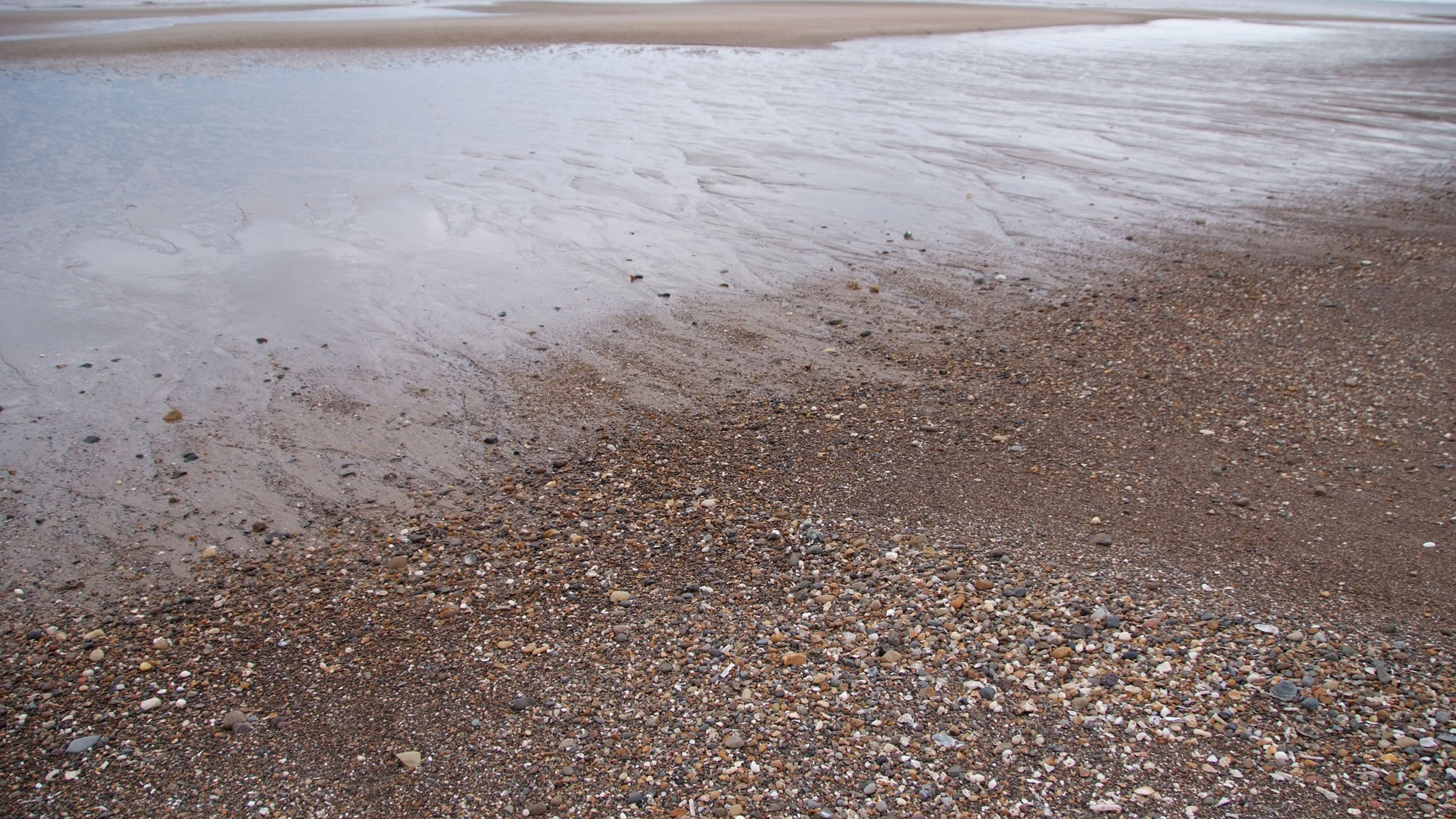
Anderby Creek offers a patient search among loose stones rather than a continuously fossiliferous cliff or rock platform. The older beach record includes ammonites, belemnites, echinoids, corals and bivalves in rocks described as Carboniferous, Jurassic and Cretaceous. Finds are scattered and can be well worn. A wide expanse of clean sand may conceal almost all of the stony material, so the best starting point is whichever naturally exposed pebbly patch can be reached safely on that visit.
The original observations place fossil-bearing stones in low-tide channels and on surfaces uncovered by scouring. Look along the edges of shallow runnels and patches where waves have left coarser material, keeping a clear route back to the upper beach. Scan the natural surfaces of the smaller loose stones before considering a larger block: weathering and abrasion may already reveal a shell, coral pattern or fossil cross-section. Scouring can improve visibility, but rough seas are a reason to postpone a search rather than approach the water more closely.
An ammonite may show a coiled outline, curved ribs or part of a chambered shell. A belemnite guard is more likely to appear as a solid tapered fragment, sometimes with a circular or oval cross-section. Rounded pebbles can expose only an internal slice, so a ring, spiral or pale patch alone is not enough for a confident identification. Photograph several faces and keep the surrounding rock in the picture; its colour, texture and other fossils may help narrow the possibilities.
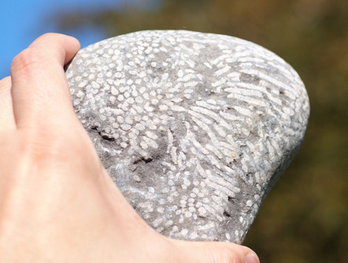
Echinoids can retain part of a rounded test with repeated rows of pores or a five-part pattern. Corals may show repeated individual tubes or cups, sometimes with radiating internal partitions. Bivalves are recognised by valves, growth lines, shell fragments or moulds left after the shell has gone. Wear can remove these useful features, and a strongly patterned rock need not preserve a complete fossil. The locality’s older records support these broad groups, but do not provide a reliable species list for every beach stone.
Keep the age of an older fossil separate from the age of the sand around it. A diagnostic fossil and its matrix may suggest a geological period, even when its original bed and source locality remain unknown. Beach transport can mix rocks of quite different ages together. Record a permitted specimen as a loose Anderby Creek beach find, with the date, location and rock type; do not automatically label it as coming from a particular Yorkshire formation or a Holderness cliff.
The Holocene deposits preserve a different kind of evidence. In a paper published in 1969, Robert C. Alvey described two sediment samples from opposite sides of the creek. The northern sample crossed the boundary between black peaty clay and saltmarsh clay. Its plant remains included hazel nuts identified as Corylus avellana, an oak acorn identified as Quercus sp., and bramble fruitstones identified as Rubus fruticosus L. agg. These small remains reveal former vegetation far more precisely than the outline of a weathered piece of wood alone.
Alvey attributed the northern sample’s plants to the lower, wooded peaty deposit and its small snail, identified as Hydrobia ulvae, to the saltmarsh clay above. The southern sample came from freshwater clay beneath the sand and included plant remains, a moss fragment, a terrestrial snail identified as Helix nemoralis and ostracods. These are historical identifications retained from the paper. They describe material recovered and examined from sediment samples, not a prediction of what a visitor will find lying on the beach.
The scientific value of peat, rooted wood and clay contacts lies in their position as well as their contents. If dark organic sediment or possible rooted wood is exposed, photograph it in place with a scale and a wider view of the surrounding layers. Note the location and tide conditions without digging, peeling away peat or pulling out roots. Loose modern wood, shells and plant fragments on the surface cannot be assigned to the buried Holocene sequence merely because they occur nearby.
For any collecting that is currently permitted, choose modest naturally loose mineralised material and leave large boulders, rock armour and structures untouched. A lens and clear photographs usually do more for identification than splitting an unfamiliar stone. Keep unusual finds with their full context and seek specialist advice before preparation; waterlogged organic remains require a different approach from durable fossiliferous beach pebbles.
Discoveries and milestones
Significant discoveries, geological research and conservation milestones at Anderby Creek.
1969 – Woodland and wetland remains documented at the creek
Robert C. Alvey published two precisely located Anderby Creek sediment samples. The northern sample crossed a peaty-clay/saltmarsh boundary, separating woodland plant remains from a saltmarsh mollusc; the southern sample recorded freshwater clay beneath the beach sand. The work connected small plant and animal remains to particular horizons and showed how contrasting environments could be distinguished within a condensed foreshore succession. The year records publication, not a verified collection date.
2011 – Beach surveys distinguish local sediment changes
Comparison of surveyed profiles from 2006, 2010 and 2011 documented changes in the Anderby Creek foreshore at transects L2C5–L2C6. The assessment described redistribution between upper and lower beach levels and distinguished this reach, which had received no recent renourishment at that time, from nourished ground farther south. The record is important when interpreting why older deposits may be exposed or buried, while remaining a historical assessment rather than a description of present conditions.
Geology
The geology visible at Anderby Creek has several overlapping histories. Mobile modern sand covers the foreshore, scattered older fossiliferous stones have arrived by transport and reworking, and Holocene organic and clay-rich deposits have been recorded beneath the beach. The occurrence of Carboniferous, Jurassic or Cretaceous fossils in loose stones therefore does not create a local bedrock succession of those ages. It is the younger buried wetland record that preserves direct evidence of changing conditions at the creek.
Waves and currents redistribute sand and coarser material, exposing some patches while burying others. Some older stones may have passed through glacial deposits before reaching the beach. Regional southward sediment movement offers a transport mechanism, but cannot identify the original source bed or coastal journey of each fossiliferous cobble. This distinction matters when labelling a find: an age inferred from a fossil is a different question from where the rock originated.
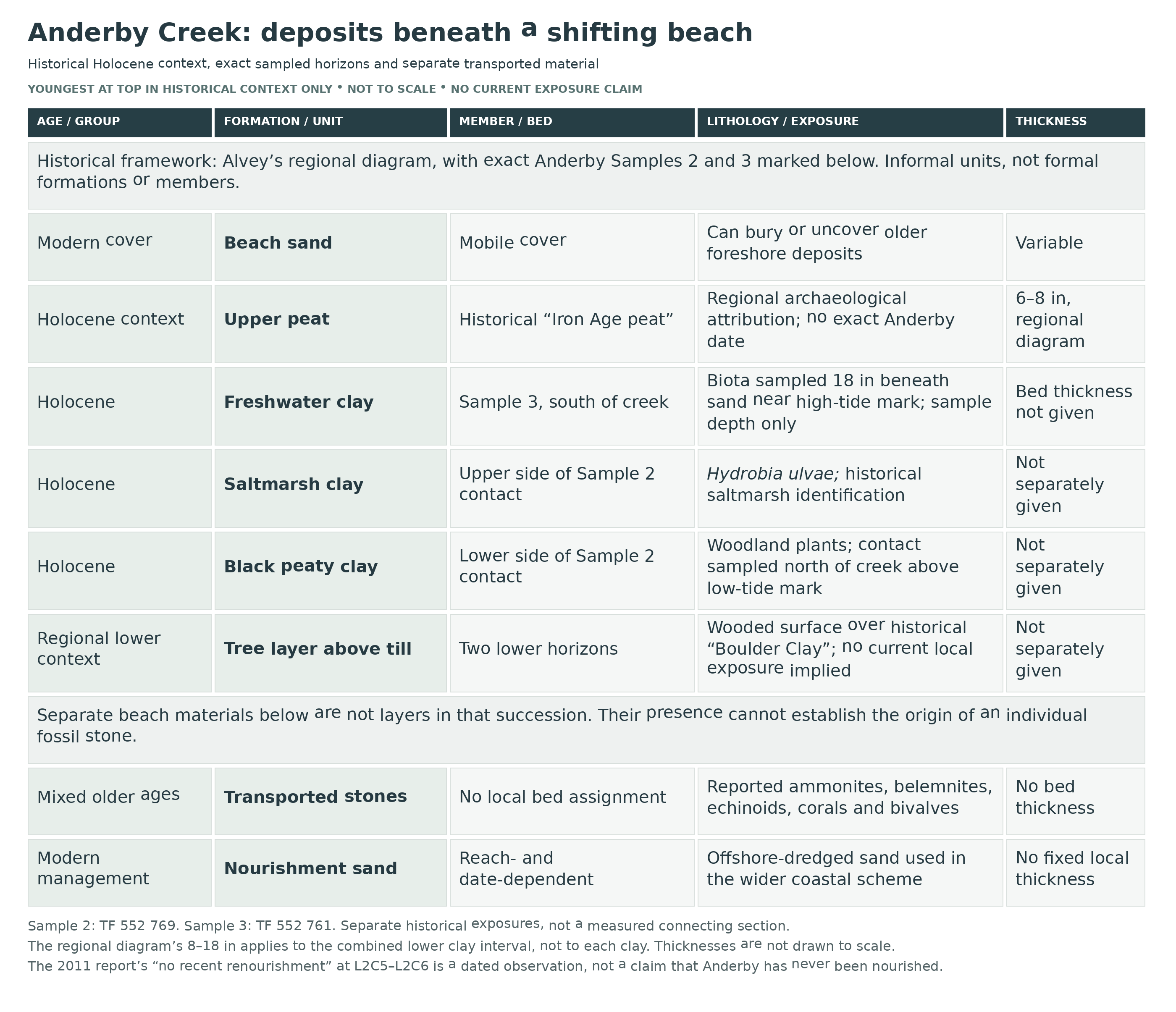
Alvey’s 1969 account places the Anderby samples within a Holocene sequence described using informal terms such as black peaty clay, saltmarsh clay and freshwater clay. His regional diagram shows a tree layer above till, followed by the clays, an upper peat and beach sand. These names describe sediment and environment; they should not be treated as verified formal formations or members. The diagram gives a useful framework, while the two Anderby samples provide the firmer evidence for particular local horizons.
North of the creek, a sample taken just above low-tide mark crossed from black peaty clay below into saltmarsh clay above. Woodland plant remains were assigned to the lower part, and a saltmarsh snail to the upper part. South of the creek, another sample was taken 18 inches beneath the beach sand at about high-tide mark and was assigned to freshwater clay. The woodland, saltmarsh and freshwater evidence records changing local environments, including terrestrial material entering wetland sediment. It cannot be reduced to a single uninterrupted advance of the sea, or joined into a modern measured section between the two sample points.
Sand cover is also affected by beach management. Monitoring published in 2011 distinguished the Anderby transects described as having had no recent renourishment at that time from nourished ground farther south. Later notices describe an Anderby compound for the 2025–2027 scheme and the use of offshore-dredged sand in the wider 2026 programme. Both natural movement and management can alter beach levels and the visibility of older deposits. Those dated records do not establish a current closure, annual placement on every part of this beach or the origin of an individual fossil stone.
Detailed geology and bed-by-bed succession
Detailed geology of Anderby Creek’s historical foreshore deposits and exact sampled horizons.
Scope of the succession. The firmest locality evidence is provided by Alvey’s two Anderby Creek samples, published in 1969. His accompanying diagram is a broader, condensed foreshore succession for the Ingoldmells area. The informal units below are described from oldest to youngest, with exact Anderby observations identified separately. No formal Group, Formation or Member assignment, complete present-day exposure or continuous section between the two sample points is implied.
Till substrate, historically “Boulder Clay”. Till forms the base of the regional diagram beneath the tree layer. Alvey supplies no separate thickness or diagnostic fossil list for this unit at either Anderby sample. The historical label is retained to explain the figure; it is not assigned here to a modern named till formation. The glacial substrate in this schematic must also be kept separate from an unproven glacial origin for any particular loose beach stone.
Tree layer. The regional sequence places a wooded surface above the till and below the black peaty clay. The wider account describes tree stools, roots and fallen trunks exposed when beach sand is removed. Its archaeological discussion concerns the regional sequence, rather than a dated tree from either exact Anderby sample. The northern sample’s woodland plant remains give more specific local evidence; the diagram alone does not establish a currently exposed forest beside the car park.
Black peaty clay: lower part of Sample 2. At TF 552 769, just north of the creek and just above low-tide mark, Sample 2 crossed the junction from black peaty clay below into saltmarsh clay above. Alvey assigned the plant remains to the lower division and interpreted them as an oak/brush woodland assemblage. This contact relationship is the important exact-site observation. No separate thickness is given for the black peaty clay at this sample point.
Sample 2 plant record. The following identifications and quantities reproduce the historical table: Atriplex spp., 4 seeds; Corylus avellana, 13 nuts; Crataegus monogyna, 1 fruitstone; Iris pseudacorus, 1 seed; Prunus spinosa, 1 fruitstone; Quercus sp., 1 acorn; Ranunculus spp., 2 achenes; Rubus fruticosus L. agg., 25 fruitstones; and undetermined buds, 5 specimens. These are counts recovered from one studied sediment sample, not estimates of beach abundance or visitor find frequency. The historical taxonomic identifications have not been silently revised.
Saltmarsh clay: upper part of Sample 2. The upper side of the same sampled contact yielded 11 specimens identified as Hydrobia ulvae. Alvey treated this mollusc as the saltmarsh component and assigned it to the upper division, separately from the plant-bearing peaty clay below. A sample crossing a boundary brings together material from two horizons; its combined contents should not be pictured as one undifferentiated living community. The saltmarsh clay has no separately established local thickness in this record, and the snail’s name is retained as a historical identification.
Freshwater clay: Sample 3. At TF 552 761, just south of the creek around high-tide mark, Alvey collected Sample 3 from 18 inches beneath the beach sand. This is the reported sampling position below sand, not an 18-inch thickness for the freshwater clay. Its biota was assigned to the freshwater-clay interval, which appears above saltmarsh clay in the regional diagram. The two sample localities were separate exposures; their differing shore positions are not a measured dip or a continuous present-day traverse through the beds.
Sample 3 plant and animal record. The historical table lists Atriplex spp., 48 seeds; Centaurea nigra, 1 achene; Cirsium spp., 3 achenes; Ranunculus sp., 1 achene; Rubus fruticosus L. agg., 4 fruitstones; Schoenoplectus lacustris, 2 achenes; an undetermined bryophyte fragment, 1 specimen; Helix nemoralis, 4 specimens; and undetermined ostracods, several specimens. All names and quantities remain historical sample records. The combination includes terrestrial plants and a land snail as well as wetland evidence, so “freshwater clay” should not be read as an exclusively aquatic fauna.
Upper peat, historically “Iron Age peat”. Alvey’s regional diagram places an upper peat above the freshwater clay and beneath the beach sand, with a thickness of 6–8 inches. The historical age label was tied to archaeological evidence in the broader coastal sequence. It does not provide a direct date for either Anderby sample or prove that the illustrated pot came from this exact beach. No direct radiocarbon age is established here for either Anderby sample.
Thickness and correlation limits. The regional diagram gives 8–18 inches for the combined lower clay interval, rather than for each clay separately. Alvey described a condensed succession no more than about 2 feet thick in the studied exposures, compared with about 7 feet in Swinnerton’s earlier regional account. These figures describe different scopes of observation and should not be added together or treated as a modern measured section at Anderby. The clays were difficult to distinguish by lithology alone; their different biota supplied important environmental evidence.
Modern beach-sand cover. Sand overlies and intermittently conceals the older organic and clay-rich foreshore deposits. Changes in waves, channels and beach levels can uncover a small exposure and later bury it. The sampled positions document past occurrence, not current visibility. A loose mineralised fossil lying on the sand may be far older than both this mobile cover and the Holocene deposits beneath it.
Separate transported older material. The beach-find record includes ammonites, belemnites, echinoids, corals and bivalves in rocks described as Carboniferous, Jurassic and Cretaceous. These scattered stones do not form an in-situ older-rock succession here. Natural reworking, possible earlier glacial transport and coastal redistribution can explain mixing, but neither a universal Holderness origin nor a specific source bed is established for each find. Their geological age, where identifiable, must be recorded separately from uncertain provenance.
Beach nourishment and sediment redistribution. The 2011 monitoring report records no recent renourishment between Anderby transects L2C5 and L2C6 at that time, while describing sediment redistribution and separately documenting nourishment at Wolla Bank farther south. A March 2025 parish notice identifies an Anderby Creek compound for the 2025–2027 scheme. The wider 2026 programme uses sand dredged from licensed seabed areas. These are time- and reach-specific management records: they demonstrate another way in which beach sand can change, without identifying the origin of an individual fossil or proving annual placement everywhere at Anderby.
Preservation and the historical specimens. Alvey recovered the assemblages by laboratory examination of sediment, including hand-picking larger pieces and wet-sieving residues. His plate illustrates kinds of remains represented in Sample 2, including an acorn, bramble fruitstone, hazelnut, yellow-flag seed and the small saltmarsh snail, but the whole plate is not an exclusively Anderby collection. The pictured fish-bone fragment belongs to the separate Sample 1 record south of Chapel St Leonards and is excluded here. The paper reported the figured specimens deposited in the Archaeology Museum, University of Nottingham; that is historical repository information, not a confirmation of their present location. The original analytical method is not a collecting recommendation for visitors.
References. Alvey, R. C. (1969), “Post-glacial fauna and flora from inter-tidal exposures in the Ingoldmells area, Lincolnshire”, Mercian Geologist 3(2), 137–142, Text-Figure 1 and Plate 8. Environment Agency (June 2011), Coastal Morphology Report: Lincolnshire (Mablethorpe to Skegness), RP023/L/2011, Anderby Creek–Chapel St Leonards section, Figures 19 and 21 and Table 3. Anderby Parish Council, beach-management notice, 17 March 2025. Environment Agency, Lincolnshire annual beach-work announcement, 8 June 2026. The original UK Fossils Anderby Creek guide supplies the older loose-stone find record.
Safety
Check local tide times, weather and sea conditions before setting out. Low-tide runnels can refill while higher patches of sand remain exposed, so watch the route behind you as well as the water ahead. Return before the tide reaches your intended route and keep a generous margin in poor weather. A broad, gently sloping beach still requires tidal awareness.
Soft clay, peat, wet sand and the edges of channels can give uncertain footing. Avoid deep or flowing channels and turn back if the surface will not support you. Keep children closely supervised near water. Stay away from the outfall, its slippery rock armour and any area reached by waves; do not climb structures or move their stones.
Beach-management operations can involve heavy machinery, pipes and temporary barriers. Follow the signs and staff instructions at the time of your visit, giving active works a wide berth. The dates in older notices are not a reliable guide to which area is open on the day.
Equipment
Take footwear with good grip, suitable clothing for an exposed coast, tide information, a charged phone, a camera and a hand lens. A notebook and small scale help record finds and exposed sediment without disturbing it. For authorised loose-stone collecting, bring a few separate bags or small rigid boxes with labels. A hammer is unnecessary for a normal beach search and must not be used on rock armour, structures or in-situ organic deposits.
Cleaning And Treating
Photograph and label any lawfully collected mineralised stone before cleaning, retaining a little of the surrounding matrix. Begin with a soft brush and work under a hand lens. A brief freshwater rinse may help a sound, hard pebble, but avoid soaking porous or clay-rich material until its stability is known. Let suitable damp mineralised specimens dry slowly at room temperature and protect weak shells or projecting edges during storage.
Do not use household acids on uncertain specimens: calcitic shells, corals and limestone can all be damaged. Avoid bleach, routine varnishing and forcing hard matrix away where the fossil breaks with it. Fine mechanical preparation may need specialist help. Waterlogged wood, seeds and other organic subfossils must not be treated like stone; leave in-situ material in place and obtain conservation advice rather than drying, scrubbing or coating it.
Identify Your Finds
Need help identifying a fossil? Share clear photos, where you found it and its size with the community.
Further Reading
Robert C. Alvey (1969): post-glacial fauna and flora, including the two Anderby Creek samples
Environment Agency (2011): coastal monitoring, including the Anderby Creek beach profiles
Visit Lincolnshire: Anderby Creek access and coastal walking route
Lincolnshire County Council: current coastal car park information
Environment Agency: the 2026 Lincolnshire beach-management programme
Access Rights
Official visitor information provides beach and coastal walking access from the Anderby Creek car park. This does not itself grant permission to remove fossils, dig clay or peat, or use tools. Before collecting, check the current landowner or site-management guidance for the particular area and activity. Keep any permitted collecting small-scale and confined to suitable naturally loose material.
Protected geological and wildlife sites occur along the adjoining coast, including the Chapel Point–Wolla Bank geological SSSI farther south and separate sensitive dune and wetland areas. The Anderby Creek access point lies north of the mapped Chapel Point–Wolla Bank boundary, but that is not a blanket statement about every stretch of beach or the right to take material. Keep to appropriate access routes, respect wildlife and leave in-situ peat, rooted wood, clay contacts and coastal defences intact.
It is important to follow our ‘Code of Conduct’ when collecting fossils or visiting any site. Please also read our ‘Terms and Conditions‘
Links
♦ Fossil Discussions
♦ Fossil Articles
♦ Buy Fossils, Tools and Equipment
♦ Buy Crystals, Meteorites, and Artefacts
♦ Join Fossil Hunts
♦ UK Fossils Network


