

Overview
Directions
- Annbank lies beside the River Ayr, east of Ayr. The original guide describes two exposures on the river’s left bank, defined looking downstream: one opposite the village and another just south of old bridge piers, a little under 2 km north of Tarholm Bridge.
- Use the River Ayr Way for the walking approach. Through Annbank, the route leads from Dunlop Avenue and Braeside into Mill Road, continues towards Privick Mill and follows the riverside corridor to Tarholm Bridge. The crossing connects with the route towards Auchincruive. Follow current waymarks and diversions, using existing paths and bridges rather than cutting across fields or wading across the river.
- The council’s Annbank and Mossblown paths leaflet marks parking at the edge of Mossblown and further parking at Auchincruive for the wider walking network. These are walking-route options, not a dedicated fossil-site car park. Keep entrances clear and check signs before leaving a vehicle.
- The old guide’s locality reference is 55.47424° N, 4.52001° W. Scott’s historic measured section is separately recorded at NS 400 234 beside the old piers, about 940 m from that point. Neither reference is a verified parking place or present-day bank entrance. Do not assume the measured beds described below lie at the website coordinate.
- The public walking route does not establish safe access to every river exposure. A current safe descent and permission to collect must be confirmed before approaching the fossil bank; vegetation, erosion or river conditions may prevent access. If the approach is unsafe, remain on the established path and leave the bank unvisited.
Location photographs
Swipe to browse · Select a photograph to enlarge


Fossil Hunting
Annbank’s interest is its plant-bearing shale and siltstone, rather than a mixed assemblage of shells and other marine fossils. The best documented material comes from the old-pier section studied by Andrew C. Scott. There, the thin coal is overlain by grey silty shale, dark shale and reddish-grey silts containing several distinct plant horizons. The main compression flora occurs in his Beds 2–4, with plant fragments concentrated towards the tops of small sedimentary cycles. A red colour alone is therefore no reason to dismiss a piece as barren. Conversely, the overlying sandstones and rooted silts did not yield comparable foliage in his study.
Where permission allows collecting and the approach is safe, examine a small number of already loose, weathered shale fragments for flat plant impressions on natural bedding surfaces. Look across the surface in low-angle light for the outline of a frond, branching veins or a narrow stem. Fine-grained pieces can preserve details that are lost in coarser, gritty rock; a dark patch without a clear margin or venation may be only fragmented plant debris. Avoid levering fresh slabs out of the finite riverbank horizons. A loose piece can reveal the flora, but it cannot be assigned to a numbered bed simply from its colour.
Much of the recorded foliage belongs to pteridosperms, commonly called seed ferns because their fronds resemble those of ferns although they reproduced by seeds. Alethopteris, Neuropteris and Mariopteris are central to the historical Annbank assemblage. Frond fragments may retain several small leaflets, or pinnules, on an axis; other finds are isolated pinnules. Keep the attachment, outline and veins visible in photographs, since these features matter more for identification than overall colour. Scott’s illustrated material called Alethopteris lonchitica in a broad historical sense was later included in Alethopteris urophylla. His Neuropteris pseudogigantea commonly occurred as isolated, rather straight-sided pinnules; the paper also discusses the combination Paripteris pseudogigantea.
Mariopteris muricata and foliage compared with Mariopteris sauveri add to the variety, but small broken pinnules should not be forced into a species. Scott used differing levels of confidence for some specimens, including Neuropteris cf. loshi and Mariopteris aff. sauveri in his illustrations. Those qualifications remain useful: they show that a close resemblance is not a secure identification. The detailed section retains historical sample names separately from later interpretations of particular museum specimens.
Cordaites principalis has a very different appearance: broad, strap-shaped leaves with parallel venation. Scott recorded leaves reaching about 5 cm wide and 50 cm long, although they commonly split lengthways into ribbon-like strips and seldom retained their tips. Those dimensions describe his specimens, not the size of a likely modern find. A short ribbed strip may be a leaf fragment rather than a stem, so examine its veins and margins before labelling it. These detached leaves occur through much of the plant-bearing succession and do not establish where the parent tree grew.
Sphenopsids, the group including the ancient relatives of horsetails, become more conspicuous in the upper part of the sampled roof shales. Calamites occurs as ribbed, jointed stem or pith casts, with Calamites cisti figured from Bed 4g. Annularia radiata and Asterophyllites equisetiformis represent foliage arranged in whorls around slender axes, while Sphenophyllum bears small wedge-like leaves. Branching traces assigned to Pinnularia are root remains, not fern fronds. Recording a piece’s orientation and its relationship to the bedding helps distinguish detached plant fragments from roots penetrating the sediment.
The rare reproductive structures are especially important scientifically. Two Cordaitanthus inflorescences from Bed 2a preserve a slender central axis with alternating short shoots and long bracts. Scott considered them potentially distinctive but did not name a new species. Winged seeds of Samaropsis pyriformis are also recorded, including an illustrated specimen from Bed 2d measuring 14 by 9 mm. Trigonocarpus is present in the historical records, but the figured museum example has no recorded bed. These are documented uncommon finds, not a promise that such structures are readily available today. Photograph an unusual specimen in place with a scale and seek specialist advice before attempting removal.
The thin coal and its rooted floor tell a different botanical story from the foliage above. Stigmaria rootlets record the peat-forming vegetation, while microscopic spores in the coal indicate a strong lycopod contribution. Most of the overlying frond material was transported before burial, so a collection of loose leaves cannot be treated as a complete forest preserved where it grew. The older guide’s poor-yield and over-collecting comments describe its 2008 inspection; there has been no new field assessment to establish present abundance. A careful photographic record is valuable even when no collecting is possible.
Discoveries and milestones
A chronological record of plant collecting, geological research and taxonomic revisions at the Annbank riverbank exposures.
1949 – The riverbank flora enters the Survey record
The Geological Survey recorded fossil plants in the riverbank opposite Annbank, just south of the piers of an old bridge. The section was placed between the Top Ell Coal and Skipsey’s Marine Band, providing the stratigraphic framework used in later work.
4 July 1964 – Organised plant collecting on the River Ayr
M. Yuill led a Geological Society of Glasgow excursion to collect Coal Measures plants beside the River Ayr at Annbank. The record documents organised collecting at the locality before the later quantitative studies.
10 December 1964 – Old-bridge plants presented to the society
M. Macgregor presented Carboniferous plants collected near the old bridge at Annbank during the society’s Members’ Night. This specifically links the old-bridge exposure with the local scientific collecting record.
13 February 1975 – Scott exhibits the Annbank plant assemblages
Andrew C. Scott gave a talk on the Westphalian B plant assemblages of Annbank, illustrated with exhibits. It documents presentation of the site’s plant material before publication of his detailed ecological study.
1977 – A measured section reveals contrasting plant communities
Scott published a five-metre measured section and a bed-by-bed study of the Annbank flora, comparing plant compressions in the roof shales with spores from the underlying coal. The coal recorded predominantly lycopod and sphenopsid vegetation, while the overlying transported assemblages contained abundant seed-fern foliage and Cordaites, with sphenopsid remains becoming more conspicuous upwards. His illustrated material was documented in the Hunterian Museum, including two unusually large Cordaitanthus inflorescences. These were discussed as possibly distinct, but no new species was named.
2008 – The figured Alethopteris material is reclassified
Robert H. Wagner and Carmen Álvarez-Vázquez included Scott’s illustrated Annbank material in their revision of Alethopteris urophylla. This clarified the identity of specimens previously called Alethopteris lonchitica in a broad historical sense and followed the uncertainty Scott had already recognised. The Annbank specimens are referred material, not the species’ type specimens.
Geology
The studied Annbank plant beds belong to the Scottish Middle Coal Measures Formation within the Scottish Coal Measures Group. They are Duckmantian in age, corresponding to the historical Westphalian B terminology used by Scott, who considered the flora probably high within that interval. This is a small window into the Carboniferous landscape, not an exposure of the full formation. The five-metre section published in 1977 was measured beside the old bridge piers; it must be distinguished from the original guide’s separate coordinate and from other rocks exposed along the River Ayr.
At the bottom of the section, roots penetrate a dark, mica-bearing seatearth beneath a thin coal. A seatearth is the former soil or rooted substrate on which peat accumulated. The transition into shaly and brighter coal records plant material building up in a wet setting before burial and coalification. It is a much firmer indication of vegetation growing locally than the scattered leaves above it. The twelve-centimetre coal is not identified as the Top Ell Coal: that named seam and Skipsey’s Marine Band provide the historical stratigraphic bracket for the section, rather than two markers shown within the measured five metres.
Peat accumulation was followed by repeated inputs of sand, silt, mud and plant debris. In the lower roof shale, eleven small packages become finer upwards, often finishing with a plant-rich surface. Flat leaves helped form the apparent lamination and natural splitting surfaces. A darker shale follows, then reddish-grey, locally iron-rich silts containing further plant horizons. These changing grain sizes and bedding surfaces influence both the quality of preservation and the kinds of fragments retained. They explain why one slab can carry recognisable foliage while another nearby piece contains only broken debris.
Higher in the section, an erosion-based sandstone is succeeded by rooted silts with red-and-green mottling and small rounded aggregates of siderite, an iron carbonate mineral. A final micaceous sandstone has a sharp erosional base and small-scale cross-lamination. Scott interpreted the upper rooting and mottling as evidence of fluctuating water levels and occasional exposure of the sediment surface. The red colours are part of this local Coal Measures succession; they do not demonstrate an Etruria Formation or Warwickshire Group succession.
Two closely related environmental models remain possible. A stream may have delivered sediment into a shallow lake that gradually filled and was colonised by plants. Alternatively, floods breaking through a river’s natural bank may have spread sediment across a floodplain, with the coarser upper deposits forming nearer a levée. Both explain intermittent sediment pulses and changes in the plant assemblage. The preserved evidence does not justify choosing one exact channel layout or describing the section as a demonstrated marine incursion. Similarly, the drifted foliage reflects transport and preservation as well as the original vegetation, so changing fossil proportions need not represent a simple sequence of whole forests replacing one another.
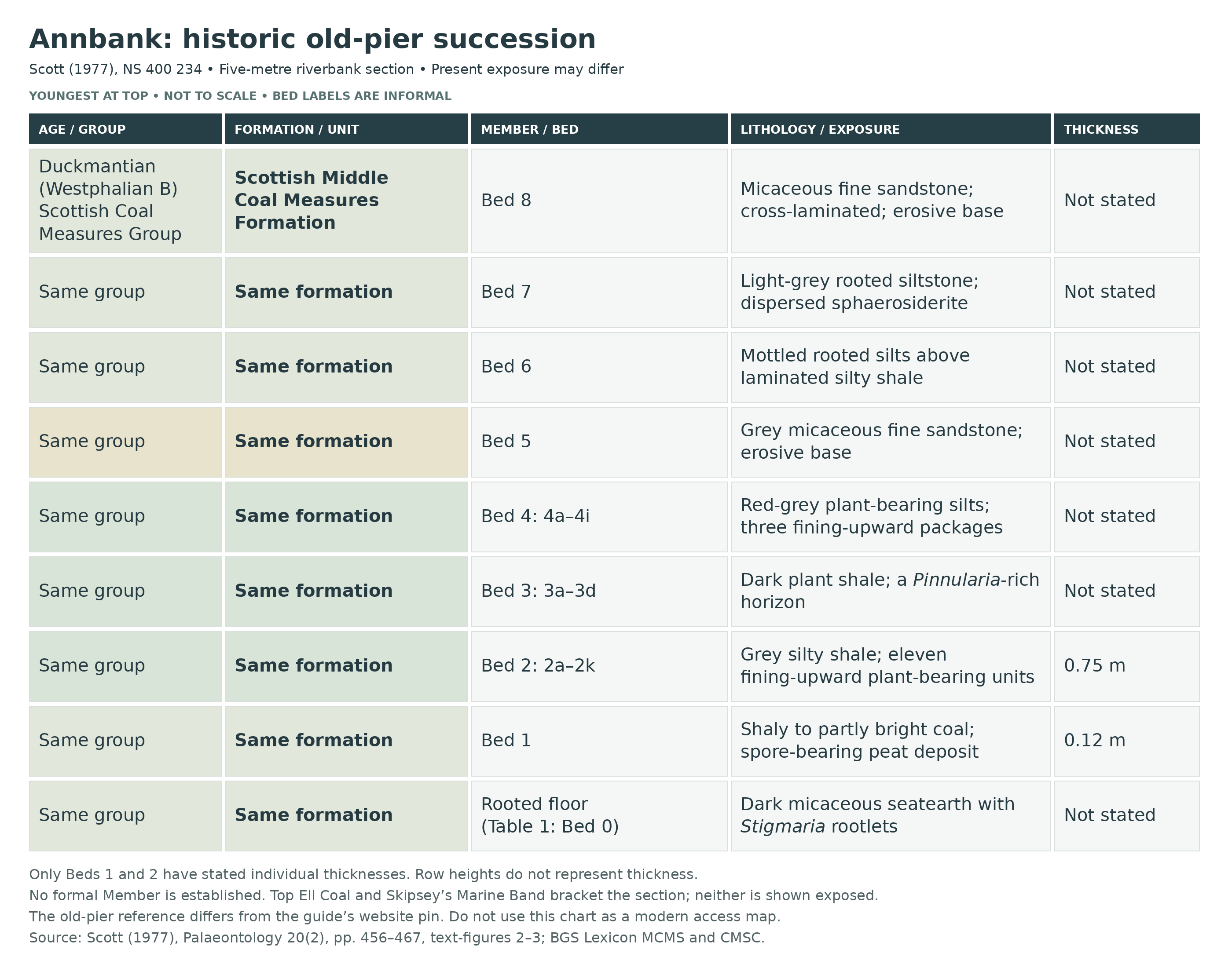
Detailed geology and bed-by-bed succession
Detailed geology of Scott’s historic old-pier section: the rooted floor, eight numbered beds and 24 fine subdivisions of the plant-bearing interval.
Scope and reading order. The succession below follows the five metres recorded by Scott in 1977 on the left bank of the River Ayr, immediately south of old bridge piers at NS 400 234. His exposed section extended about 10 m laterally. The original UK Fossils guide also describes a second exposure and gives a point about 940 m away; the measured log is not transferred to that coordinate. Beds are described from the base upwards. Numbers and letters are Scott’s informal local labels, not formal members, and present exposure may differ from the published section.
SCOTTISH COAL MEASURES GROUP
The Scottish Coal Measures Group supplies the modern regional framework for the coal, seatearth, mudstone, siltstone and sandstone succession. The local measured interval is a small part of this much larger group. Its rooted coal floor and overlying sedimentary packages preserve different stages in the development of a wetland and its surrounding alluvial environment.
Scottish Middle Coal Measures Formation
Age and correlation. The plant-bearing section is assigned to the Duckmantian, the historical Westphalian B, probably high in that interval on Scott’s floral evidence. Following the 1949 Survey account, he placed it between the Top Ell Coal and Skipsey’s Marine Band. Neither marker is identified within his measured log, and his Bed 1 coal is unnamed. In the current BGS definition, the top of the Scottish Middle Coal Measures Formation is at the base of the Aegiranum (Skipsey’s) Marine Band; older definitions placed it at the top. There is no evidence here for extending the five-metre log across that boundary into the Scottish Upper Coal Measures Formation. No formal Member is established for the studied beds.
How the fine horizons are documented. Text-figure 3 distinguishes 2a–2k, 3a–3d and 4a–4i: 24 labels within Beds 2–4. Table 1 separately tabulates only 18 of those fine subdivisions. An unlisted column is not proof that a horizon was sterile. Only Beds 1 and 2 have individual thicknesses stated in the text; the remaining beds and fine horizons are left unquantified rather than measured from the drawing. Historical cover classes describe sampled bedding surfaces, not present-day find rates or percentages of the original forest canopy.
Names and occurrence evidence. The horizon accounts retain the taxonomic scope of Scott’s table. His historical Alethopteris lonchitica auct. records are called “historical Alethopteris” below; the 2008 revision specifically includes his figured specimens in Alethopteris urophylla, rather than re-identifying every table sample. The table uses Neuropteris loshi and Mariopteris sauveri without qualification, whereas illustrated specimens are Neuropteris cf. loshi and Mariopteris aff. sauveri (cf. in the latter’s descriptive text). The illustrated Sphenophyllum is cf. cuneifolium; the table includes var. saxifragifolium with that species. These are historical identifications with retained uncertainty, not new determinations.
Basal rooted floor: Table 1 Bed 0. Dark-grey to black micaceous seatearth contains abundant stigmarian rootlets; the table records Stigmaria ficoides and indeterminate plant fragments. The rooted substrate grades into shaly coal and records vegetation growing locally before peat accumulation. Its thickness is not separately stated. This is the rooted floor beneath the coal, not evidence that all the foliage higher in the section remains in growth position.
Bed 1: thin coal, 0.12 m.
The coal is mainly shaly with some brighter parts. Scott describes a repeated transition from seatearth through shaly coal into bright coal. Recognisable macroplants were unavailable in the sampled coal, so its vegetation was investigated through spores. A channel sample yielded a count of 1,000 spores on five slides. The published rounded groups were 49% lycopods and 36% articulates or sphenopsids, contrasting sharply with the seed-fern-rich roof flora.
Bed 1 spore evidence. The principal recorded genera were Lycospora (39%), Crassispora (6%), Endosporites (4%), Laevigatosporites (23%) and Calamospora (13%). Raistrickia contributed 2%, Leiotriletes 1% and Florinites 2%; Cristatisporites, Densosporites, Schopfipollenites, Potonieisporites, Dictyotriletes, Vestispora and Cingulizonates were trace records below 1%, with 10% unidentified. These are genus-level palynological results with historical affinity assignments. Differences in spore production, transport and preservation prevent a direct conversion into the proportions of living plants, and the rounded trace entries should not be forced into a new exact total.
Bed 2: grey silty shale, 0.75 m.
Eleven small upward-fining sediment packages rest on the coal. Plants tend to concentrate at their tops, where flat foliage contributes to an apparently laminated texture and easy splitting. Seed-fern foliage and Cordaites are prominent; fragmentation and hydraulic sorting influence what survives. The uppermost package grades into Bed 3. The following lettered accounts distinguish the actual table occurrences from figured specimens and from labels shown only in the diagram.
Horizon 2a. The lowest subdivision of the silty roof shale contains historical Alethopteris, Neuropteris loshi, Neuropteris pseudogigantea, other Neuropteris, Mariopteris muricata, Sphenopteris, Cordaites principalis, Samaropsis pyriformis, indeterminate seeds, pteridosperm axes and plant fragments. It supplied the two figured Cordaitanthus inflorescences, Pb 4457a and Pb 4458. Some plants showed a preferred orientation here; Scott did not find that pattern at every horizon.
Horizon 2b. The next silty-shale subdivision records historical Alethopteris, Neuropteris pseudogigantea and Cordaites principalis, together with Calamites, branching Pinnularia root material and indeterminate fragments. The stem and root organs distinguish this sample from a foliage-only assemblage without demonstrating that they were attached to one another.
Horizon 2c. Historical Alethopteris, Neuropteris pseudogigantea and Cordaites principalis are recorded with indeterminate fragments in this part of the eleven-cycle roof-shale sequence. No separate thickness or distinctive contact is described for this fine label.
Horizon 2d. Historical Alethopteris, Neuropteris pseudogigantea, unidentified Mariopteris and abundant indeterminate material occur with the reproductive-organ record Aulacotheca and winged seeds of Samaropsis pyriformis. The figured seed Pb 4469 is explicitly from 2d. It is referred Annbank material; the species’ type specimens were from Nostell Brickworks in Yorkshire.
Horizon 2e. This succeeding subdivision records historical Alethopteris, Neuropteris loshi and Cordaites principalis, plus indeterminate fragments. It continues the lower succession’s seed-fern and cordaitalean association; no additional horizon-specific measurement is published.
Horizon 2f. Historical Alethopteris and indeterminate plant fragments are the entries in Table 1. The restricted recorded assemblage is a result for this sampled horizon, not proof that only one kind of plant lived in the surrounding landscape.
Horizon 2g. Historical Alethopteris, Neuropteris pseudogigantea, unidentified Mariopteris, Cordaites principalis and indeterminate fragments occur with Annularia radiata. This table record places sphenopsid foliage within Bed 2, despite a later sentence in the paper saying it first appears in Bed 3. The robust interpretation is an upward increase in its prominence, not a strict first appearance at Bed 3.
Horizon 2h. Neuropteris loshi, other Neuropteris, indeterminate pteridosperm axes and plant fragments are recorded. This is another discrete part of the upward-fining silty-shale succession; the table does not supply a separate lithological description or thickness.
Horizon 2i. This subdivision lies between 2h and 2j in text-figure 3 but has no separate Table 1 column. It is retained as a labelled part of Bed 2 without assigning an invented fossil list, thickness or distinctive rock type. The missing table column does not mean that the horizon was barren.
Horizon 2j. This diverse upper Bed 2 sample records historical Alethopteris, Aulacotheca, Mariopteris sauveri, other Mariopteris, Neuropteris loshi, Neuropteris pseudogigantea, other Neuropteris, Sphenopteris, Annularia radiata, Calamites cisti and Cordaites principalis. Trigonocarpus, Samaropsis pyriformis, indeterminate seeds and plant fragments are also present. Figured Alethopteris Pb 4462 is from this horizon; its two illustrations show the same specimen.
Horizon 2k. The final subdivision of Bed 2 records Neuropteris pseudogigantea, Cordaites principalis and indeterminate fragments. It is the upper end of the silty-shale sequence whose top grades into the finer dark shale of Bed 3.
Bed 3: dark plant shale.
Fine black to dark-grey shale succeeds the grey silty shale and contains abundant plants. Text-figure 3 divides it into 3a–3d, while Table 1 samples 3a, 3c and 3d. Branching Pinnularia is especially conspicuous at one level. The figured Mariopteris muricata specimen Pb 4465a is labelled simply Bed 3, so it is not assigned to a more precise lettered horizon.
Horizon 3a. The lower dark-shale sample records historical Alethopteris, unidentified Mariopteris, Neuropteris loshi, Neuropteris pseudogigantea, Neuropteris rarinervis, Trigonocarpus, Sphenopteris, Annularia radiata, Calamites undulatus, other Calamites, Sphenophyllum cuneifolium including var. saxifragifolium, Samaropsis pyriformis and Cordaites principalis, with indeterminate fragments. The rare Lepidostrobophyllum lanceolatum record is important because lycopod macrofossils are scarce in the roof assemblage.
Horizon 3b. This intervening subdivision is labelled in text-figure 3 but lacks an individual Table 1 column. It remains part of the fine dark shale; neither a separate measured thickness nor a secure horizon-specific taxon list is supplied.
Horizon 3c. Branching Pinnularia root remains dominate the recorded material, with a small contribution from indeterminate fragments. This is the highest Pinnularia cover class in Scott’s table. He considered rooting by sphenopsids a possible explanation for such concentrations, without establishing the parent plant of every detached root.
Horizon 3d. The upper dark shale contains historical Alethopteris, Mariopteris muricata, Mariopteris sauveri, Neuropteris loshi, Neuropteris pseudogigantea, indeterminate pteridosperm axes, Annularia radiata, Calamites cisti, Sphenophyllum cuneifolium including var. saxifragifolium, Sphenophyllum myriophyllum, Cordaites principalis and other fragments. Figured Pb 4454 comes from 3d and is cautiously identified as Neuropteris cf. loshi.
Bed 4: reddish-grey plant-bearing silts.
A slightly erosive, haematitic silty-sand base is followed by three upward-fining siltstone packages, locally very iron-rich and laminated towards their plant-bearing tops. Text-figure 3 labels 4a–4i. Table 1 supplies records for 4b, 4d, 4f, 4g and 4h, not every graphical subdivision. These are parts of one locally variable Coal Measures succession; the red and grey colours do not create an Etruria Formation or Warwickshire Group unit.
Horizon 4a. The base of Bed 4 is a red, iron-rich, haematitic silty sand with slight erosion into the underlying interval. It marks a change to coarser sediment input above the dark shale. No separate Table 1 fossil column or numerical thickness is given.
Horizon 4b. The first separately tabulated plant horizon in the reddish-grey succession records Neuropteris pseudogigantea and indeterminate fragments. The illustrated pinnule Pb 4440 comes from this horizon. Its identification is the historical one discussed by Scott alongside the Paripteris combination.
Horizon 4c. This labelled interval falls between 4b and 4d within the three upward-fining siltstone packages. It has no separate Table 1 entry or individually stated thickness; no fossil absence or distinct lithology is inferred from that omission.
Horizon 4d. Historical Alethopteris, Neuropteris pseudogigantea and indeterminate plant fragments are recorded in this plant-bearing subdivision. It demonstrates the continuation of seed-fern foliage into the red-grey silts above Bed 3.
Horizon 4e. Shown between 4d and 4f in the fine log, this subdivision has no separate Table 1 column. Its position within Bed 4 is retained, but a specific fossil list and individual thickness are not available.
Horizon 4f. Pinnularia and indeterminate fragments form the recorded assemblage. The concentration of branching roots is one of the features behind Scott’s suggestion of colonisation during pauses in sedimentation; it does not prove that all neighbouring foliage is rooted in place.
Horizon 4g. Calamites cisti and Neuropteris pseudogigantea occur with indeterminate fragments. The figured ribbed Calamites cisti specimen Pb 4450 is securely assigned to 4g. This is a stem or pith-cast record, distinct from the whorled foliage especially well documented above.
Horizon 4h. This varied upper assemblage includes historical Alethopteris, Mariopteris muricata, Mariopteris sauveri, Mariopteris nervosa, Neuropteris loshi, Neuropteris pseudogigantea, Sphenopteris spiniformis, Annularia radiata, Asterophyllites equisetiformis, Sphenophyllum cuneifolium including var. saxifragifolium, Cordaites principalis, Artisia, Samaropsis pyriformis, indeterminate seeds and plant fragments. Figured specimens comprise Alethopteris Pb 4449 and Pb 4446, Mariopteris aff. sauveri Pb 4444, Sphenophyllum cf. cuneifolium Pb 4443, Asterophyllites equisetiformis Pb 4442 and Annularia radiata Pb 4441. The plate captions and accession numbers control these assignments where the descriptive text’s figure pointers differ.
Horizon 4i. The final fine subdivision of Bed 4 is labelled below Bed 5 in text-figure 3. It has no individual Table 1 column, so it is retained without a fabricated occurrence list. Scott reported no comparable plant macrofossils above Bed 4, apart from unidentifiable roots in Beds 6 and 7.
Bed 5: grey sandstone.
Fine-grained micaceous sandstone overlies the plant-bearing red-grey silts across an erosive base. Its thickness is not stated individually. The coarser sediment marks a change in the local succession, but the paper does not establish a formal named channel sandstone or a new formation boundary here.
Bed 6: mottled rooted silts.
Grey micaceous silty shale is laminated in its lower part and passes into red-and-green mottled micaceous silt. Numerous roots survive as leached brown traces; Scott explicitly distinguished them from Stigmaria. Their plant identity is uncertain. Rooting and mottling support intermittent colonisation and changing water-table conditions rather than a continuation of the basal peat swamp without interruption.
Bed 7: rooted, sphaerosideritic siltstone.
Micaceous siltstone is finely laminated at the base and passes upwards into light-grey siltstone with small roots and abundant dispersed sphaerosiderite. The latter comprises small rounded siderite aggregates within the sediment. The roots remain unidentifiable and are not stigmarian. Scott interpreted this upper interval, together with Bed 6, as subject to fluctuating water levels and periodic exposure, possibly allowing sphenopsids to colonise it.
Bed 8: upper fine sandstone.
A sharp, planar erosional base is overlain by fine sandstone with conspicuous coarse mica and small-scale cross-lamination. Scott’s prose calls it reddish-grey, while text-figure 2 labels it light grey; these are differing descriptions of the same upper unit, not two separate beds. No individual thickness or plant macrofossil assemblage is reported. In his interpretation, the sandstone lay closer to the source of alluvial sediment discharge.
Depositional alternatives and lateral limits. The rooted floor and coal indicate local peat formation. Subsequent fine sediment could have entered a shallow lake through a stream, or spread across a floodplain during overbank flooding and crevasse-splay events. In the first model, silting-up led to colonisation and intermittent drainage; in the second, the coarser upper units approached levée deposits. Both were retained by Scott. The restricted lateral exposure prevented a robust quantitative survey along the bank, so vertical differences in fossil cover cannot be assumed to describe an entire plant community changing through time. A gentle dip was reported, but the historical directional notation is insufficiently clear to recast as a precise modern strike-and-dip measurement.
Museum occurrences and specimen provenance. Scott also consulted Annbank specimens in the Geological Survey collections in Edinburgh and the Hunterian Museum in Glasgow. Table 1 places Diplotmema furcatum, Annularia sphenophylloides and Lycopodites only in its unknown-horizon or museum column, alongside additional records of Aulacotheca, Trigonocarpus and Sphenophyllum myriophyllum. These cannot be inserted into a particular numbered bed. The plate captions state that all figured specimens were in the Hunterian in 1977. Cordaites principalis Pb 4459 is labelled Bed 2 without a finer subdivision; Trigonocarpus Pb 4540 has no bed attribution. Repeated illustrations of one fossil do not constitute additional specimens. The two large Cordaitanthus examples were not made types of a newly named Annbank species.
References.
Scott, A. C. (1977). A review of the ecology of Upper Carboniferous plant assemblages, with new data from Strathclyde. Palaeontology, 20(2), 447–473, plates 50–51; Annbank account, pp. 456–467, text-figures 2–3 and tables 1–5.
British Geological Survey. Scottish Coal Measures Group and Scottish Middle Coal Measures Formation, BGS Lexicon.
Smith, R. A. and Monaghan, A. A. (2013). Geology of the Ayr district. British Geological Survey, sheet 14W and part of 13. Regional framework, not a replacement for the local log.
Wagner, R. H. and Álvarez-Vázquez, C. (2008). A revision of the lower Pennsylvanian Alethopteris lonchitica (auctorum) and its identity with Alethopteris urophylla. Revista Española de Paleontología, 23(2), 157–192; the synonymy includes Scott’s figured Annbank material.
The historical 1949 Survey correlation is reported through Scott’s explicit citation and quotation of Eyles, Simpson and MacGregor, Geology of Central Ayrshire, p. 93; that original page and Mykura’s 1967 work were not directly consulted for this account.
Safety
The fossil bank combines steep, sometimes eroded ground with a fast-flowing river. Stay away in spate, after heavy rain or whenever the path or descent is unsafe. Low water does not remove deep pools, slippery algae, undercut edges or unstable rock. Do not wade to an exposure, work below an unstable face or undermine a bank. Keep clear of exposed ledges, allow room for anglers and other walkers, and turn back rather than improvise a route through vegetation. The collecting banks are not suitable for children.
Giant hogweed has been documented near Annbank and Tarholm by Ayrshire Rivers Trust. Avoid contact with tall unfamiliar riverside plants and their sap, and do not cut vegetation to uncover rocks or a route. Gloves alone do not make handling such plants safe. Wear suitable footwear and clothing, tell someone your route and expected return, and assess river and path conditions on the day rather than assuming that summer conditions will be safe.
Equipment
Take grippy walking footwear, a current route map, a charged phone, a camera, a hand lens and a notebook. A small scale in photographs helps record fine venation, seeds and branching roots. If removal of loose specimens is authorised, carry tissue or paper, rigid supports and a shallow box so thin shale pieces can travel flat. Record the location and matrix before wrapping each piece. A pick is not routine equipment here, and any tool use needs to be consistent with the permission obtained and the safety of the bank.
Cleaning And Treating
Plant compressions can be little more than a delicate film on a shaly surface. Handle the rock from underneath, retain both part and counterpart when present, and resist further splitting simply to enlarge the exposed fossil. Keep each piece supported while it dries slowly at room temperature; direct heat and sudden drying can encourage thin layers to separate. Begin with photography and, only on stable areas, very gentle dry brushing. Stop if the surface flakes.
Do not routinely soak friable shale, scrub the fossil film, use acids or bleach, or coat the specimen with varnish. A fragile or unusual reproductive structure is best left unprepared until a specialist can advise on support or reversible consolidation. Keep labels with the specimen, separating an observed bed position from an uncertain origin in loose riverbank debris. An accurate record can remain useful even if an incomplete plant cannot be named to species.
Identify Your Finds
Need help identifying a fossil? Share clear photos, where you found it and its size with the community.
Further Reading
Deposits Magazine: Geology and terrestrial life of the Carboniferous (general background)
Scott’s 1977 study of the Annbank plant assemblages and measured section
BGS Lexicon: Scottish Middle Coal Measures Formation
BGS: Geology of the Ayr district (regional context)
NatureScot: Scottish Fossil Code and guidance
Access Rights
Responsible walking access does not automatically include permission to remove fossils. Obtain permission from the landowner or relevant fossil-right holder before collecting, and follow local notices and the Scottish Fossil Code. The exact owner and current collecting consent for these banks have not been verified. Until both permission and a safe approach are established, treat a visit as observation and photography from lawful, safe access. Where collecting is expressly permitted, take only a small number of loose finds and leave the rooted floor, coal and finite plant horizons intact.
Checks of current NatureScot mapping in October 2026 found neither of the two recorded locality positions within an SSSI or mapped Geological Conservation Review site. This does not establish ownership or collecting permission, and it does not remove the need to avoid damage or disturbance. A historical GCR note for Annbank has not been confirmed by the current official dataset.
 Scotland’s fossil resource is at risk of abuse and damage, and so we must all safeguard and manage fossil collecting to ensure its survival for future generations. For this reason it is VITAL you read and adhere to the Scottish Fossil Code for ALL sites in Scotland.
It is important to follow our ‘Code of Conduct’ when collecting fossils or visiting any site. Please also read our ‘Terms and Conditions‘.
Links
♦ Fossil Discussions
♦ Fossil Articles
♦ Buy Fossils, Tools and Equipment
♦ Buy Crystals, Meteorites, and Artefacts
♦ Join Fossil Hunts
♦ UK Fossils Network


