
Overview
Directions
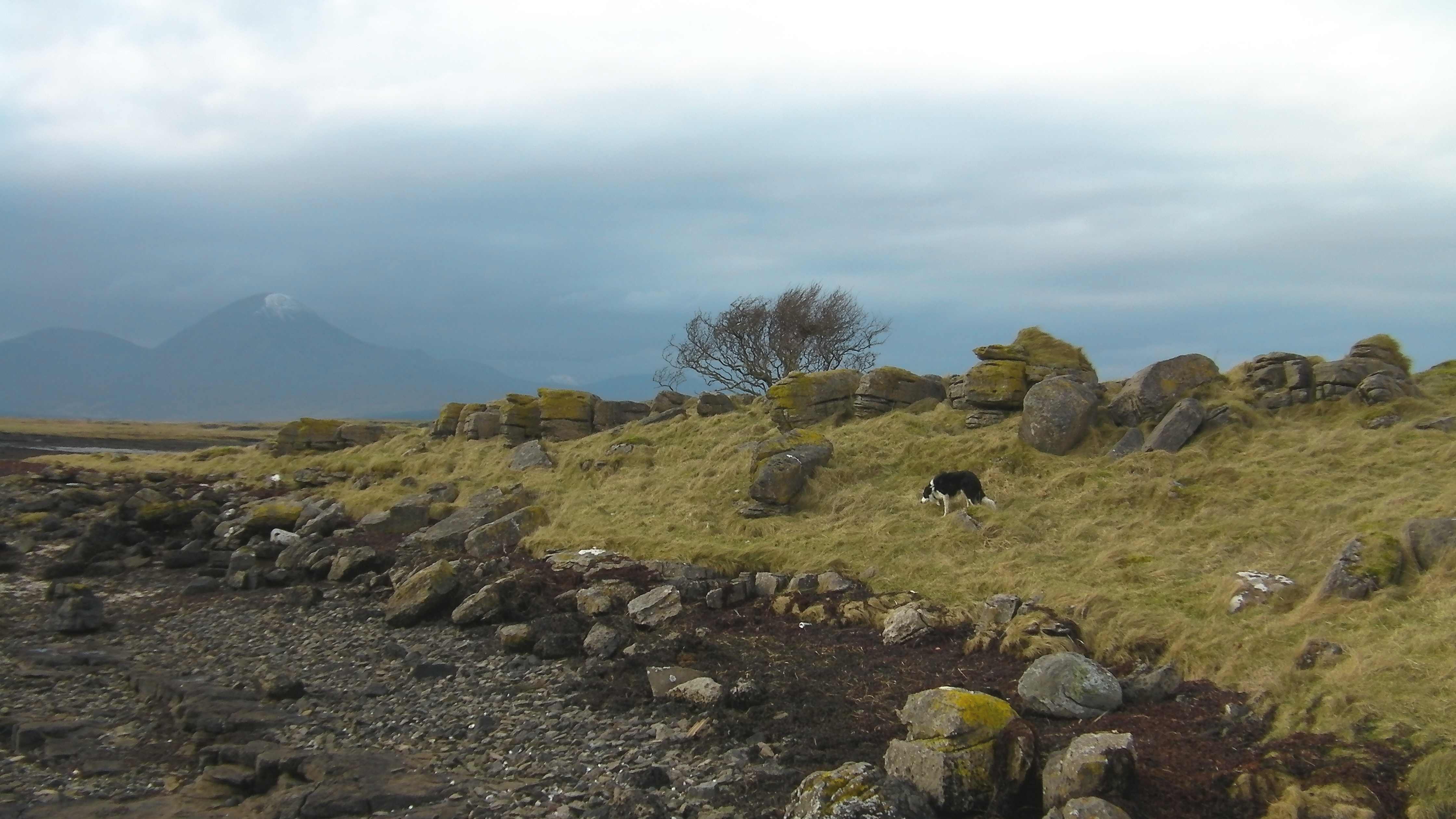
- Ardnish lies on the eastern side of Broadford Bay, on Skye. From the Skye Bridge follow the A87 towards Broadford. For the landward approach, use Waterloo or Lower Breakish and join the Ardnish community path. The path linking these townships was restored in 2023, including a bridge over the Allt Linnidal Burn. From the Waterloo road end, continue on foot through the gate towards the peninsula, then use suitable access to the shore. The improved community path does not make the intertidal fossil exposures an all-abilities route.
- Plan parking before setting out. Local visitor guidance warns that there is no parking at the Waterloo and Lower Breakish access points. Arrange lawful parking elsewhere and allow for the additional walk; do not obstruct passing places, gates, turning areas or croft access. Older geological guides describing parking at the Waterloo road end should not be relied upon.
- The traditional alternative starts at Ashaig, reached by turning off the A87 towards the cemetery and shore. Parking near the cemetery is described in local visitor guidance, but availability and current restrictions must be checked on arrival, with priority given to cemetery users. The direct route across the sands towards Ardnish crosses a river and tidal channels: it is not a dependable dry-foot approach. Plan the landward route instead of treating a low tide as assurance that wading will be safe.
- The original guide reference, 57.25419°N, 5.84622°W, identifies the coastal locality, not a verified car park or safe crossing. Plan the visit around low water, with a generous return margin. Explore the rocky fingers and inlets only while the route back remains open; do not use an unplanned upstream crossing as an escape route.
Location photographs
Swipe to browse · Select a photograph to enlarge


Fossil Hunting
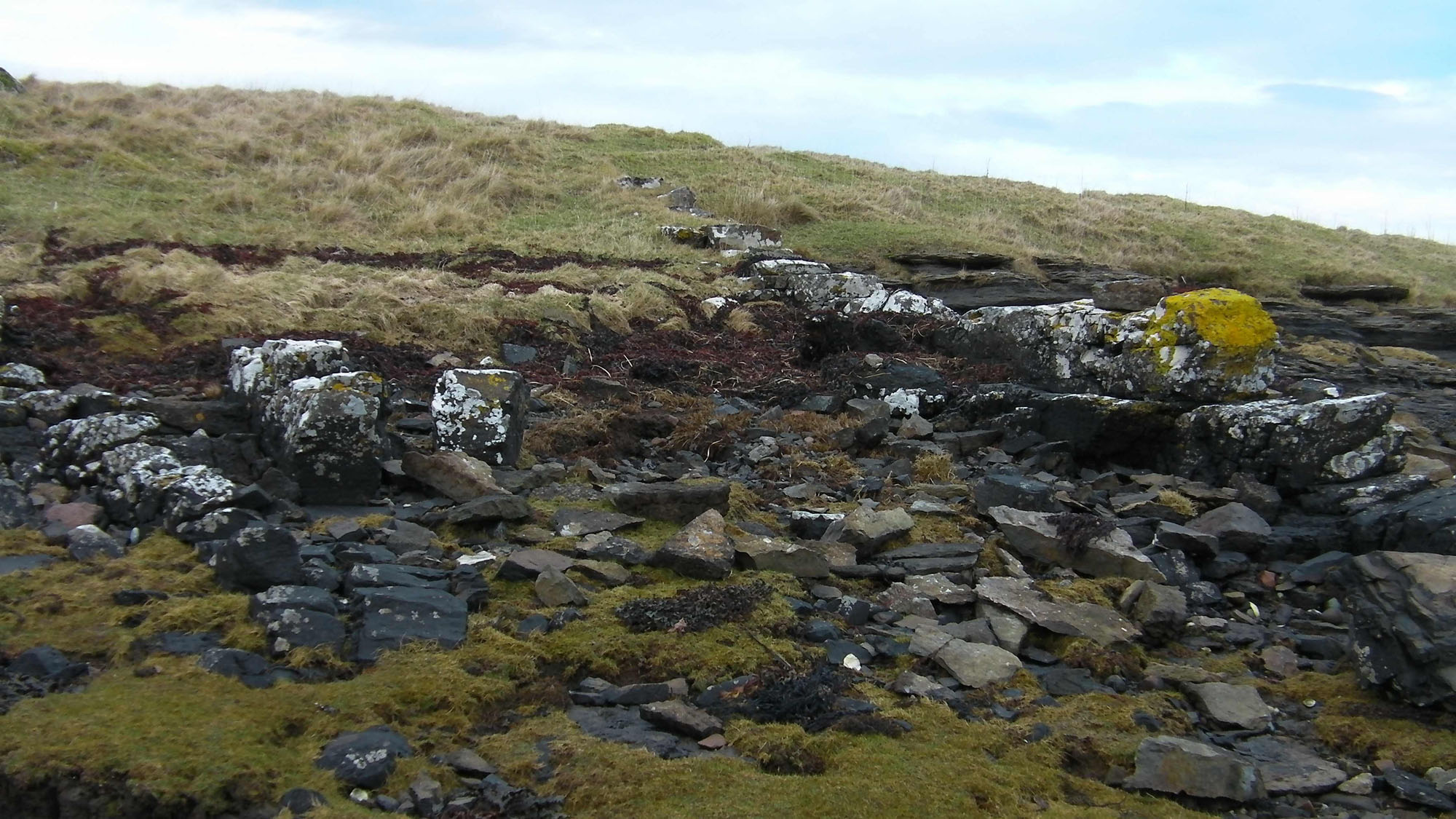
The peninsula’s broad rock platforms and small inlets expose a varied Lower Jurassic marine fauna. Fossils are concentrated in particular layers, so an apparently barren slab may lie close to a shell-rich horizon. Look across naturally weathered surfaces and loose material, rather than breaking fresh rock to search for a specimen. The eastern shores and tidal islands are part of the scientifically important Ob Lusa to Ardnish Coast section; the name of that wider site does not mean that every fossil recorded at Ob Lusa occurs at Ardnish Point.
The most recognisable fossils are the strongly curved oyster Gryphaea arcuata, commonly called devil’s toenails. Some beds contain conspicuous concentrations of these shells. Other marine bivalves include scallop-like forms and larger shells such as Plagiostoma. Brachiopods, including the small ribbed Piarorhynchia juvenis, occur in the iron-rich beds. Fossils should be recorded with their precise location and, where recognisable, the bed or rock type in which they occur.
Ammonites include Coroniceras, Arnioceras, Agassiceras and Euagassiceras. Large Coroniceras lyra are characteristic of the lower fossiliferous part of the succession, whereas Agassiceras and Euagassiceras help distinguish higher levels. Many ammonites are incomplete moulds or preserved body chambers rather than complete coiled shells. A large impression in an exposed pavement is best photographed with a scale and left in place.
The red-weathering Ardnish Ironstone and a lower iron-bearing bed are particularly useful geological markers. They contain tiny iron-rich grains as well as shells, and help explain why fossil content changes along the shore. Sandstones and siltstones above include small phosphate nodules, ammonite remains and trace fossils. Branching burrows such as Thalassinoides record activity in the sediment rather than the body of the animal that made them.
The peninsula’s fossils need to be related to their particular stretch of shore. The older, coral-bearing beds around Ob Breakish and Ob Lusa form part of the wider coastal succession, while the main Ardnish ammonite exposures lie higher in the sequence. A coral-like or bone-like shape should not be assigned a name from a nearby site without closer study. The retained historical photographs include specimens labelled as marine-reptile bones, but those identifications have not been independently verified.
Keep disturbance to a minimum and follow the access and fossil-protection guidance below. Do not hammer the bedrock or remove large fossil-bearing slabs. If you notice possible fossil bone or another unusual specimen, leave it undisturbed, photograph it and record its position privately for a museum or the relevant conservation authority. An unusual shape or an old image caption alone is not enough to establish a marine-reptile identification.
Fossil photographs
Swipe to browse · Select a photograph to enlarge


Discoveries and milestones
A chronological record of geological research and scientific milestones associated with the Ardnish Peninsula.
1910 — Broadford Beds established in the Geological Survey account
The Geological Survey memoir brought the Lower Jurassic succession around Broadford, including Ardnish, into a systematic regional account. The name Broadford Beds provided the framework within which the peninsula’s fossil-bearing shales and sandstones were subsequently studied.
1922 — Ardnish ammonites reassessed
Leonard Frank Spath published a study of ammonites from the Arnioceras-bearing beds at Ardnish. He examined their place in the Lower Lias succession and challenged earlier identifications and correlations, demonstrating the importance of accurately identified ammonites for dating these rocks.
1959 — A detailed stratigraphic framework
Anthony Hallam published a study of the Broadford Beds of Skye, Raasay and Applecross. Its measured sections and fossil correlations became a foundation for later descriptions of the Ardnish Peninsula, including the separation of lower carbonate-rich beds from the upper, more clastic succession.
1992 — Sedimentation and iron-rich beds investigated
Alison Searl’s study of the Broadford Beds examined their sedimentology and early alteration, including berthierine-rich ironstones and phosphate-bearing sandstones. This research helped explain the distinctive iron-rich horizons within the Ardnish succession.
1995 — Peninsula succession documented in a modern field guide
Nicol Morton and John Hudson’s Jurassic field guide set out detailed sections and fossil occurrences for Skye and Raasay, including Ardnish. Their peninsula log later formed the basis of the Geological Conservation Review’s numbered section.
1998–1999 — Modern formation names debated
A basin-wide revision in 1998 included the former Upper Broadford Beds within an enlarged Pabay Shale Formation. Subsequent discussion proposed treating the distinct micaceous succession as the Ardnish Formation, the name adopted in later Geological Survey mapping and used in this guide.
2004 — Geological Conservation Review synthesis
The Ob Lusa to Ardnish Coast account brought together the peninsula’s measured succession, ammonite evidence and ironstone horizons. It highlighted both the value of the extensive bedding-plane exposures and the limitations caused by faults, concealed intervals and incompletely documented upper beds.
Geology
The principal fossil-bearing rocks of the Ardnish Peninsula belong to the Ardnish Formation of the Lias Group, mostly of early Sinemurian age. They comprise mica-rich mudstones, siltstones and sandstones, with shell-rich layers and conspicuous iron-bearing beds. Shells and ammonites record life in a shallow sea, while the changing grain size shows how the supply and movement of sediment varied over time.
The Ardnish Formation was formerly called the Upper Broadford Beds. Some accounts included it in an expanded Pabay Shale Formation, which explains the older terminology in descriptions of this coast. The separate name Ardnish Formation is used by the British Geological Survey and the Geological Conservation Review. Its lower contact with the underlying, more carbonate-rich Breakish Formation is recorded in a small inlet on the peninsula’s southern side; its top is not exposed on the peninsula.
The succession records deposition on a normal-marine shelf, close to or below wave base. Repeated changes from muddier to sandier sediment produced coarsening-up packages. Ammonites place much of the section in the Semicostatum Zone, although the age of the lowest beds and precise subzonal boundaries are less certain. The upper sandier beds remain incompletely documented, so the formation cannot be reconstructed here as a complete, continuously exposed stack.
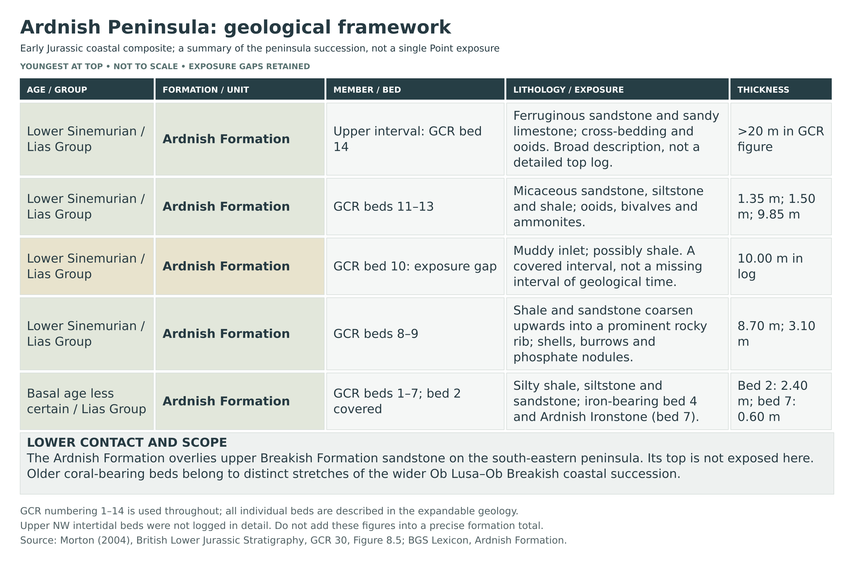
The beds generally dip gently north-westwards, and small faults complicate attempts to follow a continuous sequence. Palaeogene dykes and sills cut the Jurassic rocks and locally bake them. The detailed section below is a published composite of the peninsula shores, including intervals hidden beneath muddy inlets; it is not a single uninterrupted exposure at the point.
Detailed geology and bed-by-bed succession
Explore the Ardnish Peninsula’s published bed-by-bed succession, fossil horizons and geological setting.
This account concerns the Ardnish Peninsula, including its inlets and tidal rock platforms. The numbered succession is the Geological Conservation Review’s composite section, rather than a vertical log at Ardnish Point alone. All fourteen numbered units are retained below, including concealed intervals and the broadly described upper beds. Thicknesses are published measurements or estimates, not a new survey of present-day exposure.
LIAS GROUP
The Lower Jurassic marine succession includes the older Breakish Formation and the overlying Ardnish Formation. The principal fossiliferous peninsula exposures belong to the latter. Younger formations present elsewhere around Skye are not added to this local succession.
Breakish Formation — underlying and adjoining shore context
The more carbonate-rich Breakish Formation includes limestones, sandstones and subordinate shale. Its upper beds occur around Ob Breakish, south of the peninsula, and a thick quartz-rich sandstone forms a useful marker beneath the Ardnish Formation. On the north side of Ob Breakish, that sandstone makes a conspicuous scarp; its upper part contains quartz pebbles. The base of the Ardnish Formation is recorded at NG 6796 2422, in a small inlet on the peninsula’s southern side.
The branching coral Thecosmilia martini occurs in the Ob Breakish Coral Bed on the adjoining shore below eastern Lower Breakish. The separate Ob Lusa Coral Bed, with Heterastraea murchisoni, lies farther east at Ob Lusa. Neither coral bed is assigned here to the tip of Ardnish Point. The detailed Ob Lusa bed log is not imported into this peninsula section.
Ardnish Formation
Formerly the Upper Broadford Beds, this formation consists mainly of micaceous shale, siltstone and sandstone, with ooidal ironstone horizons and repeated coarsening-up packages. Some earlier modern accounts placed these rocks within an expanded Pabay Shale Formation; the separate Ardnish Formation name is followed here. No member boundary is imposed on the peninsula section.
Ammonites identify the early Sinemurian Semicostatum Zone through most of the succession, including the Lyra, Scipionianum and Sauzeanum subzones. The basal interval is less securely dated. The published numbered section starts again at bed 1, equivalent to bed 18 of Morton and Hudson’s 1995 account; it should not be mixed with the older 28-bed Broadford composite numbering.
Bed 1 — basal silty shale (0.65 m)
Mica-rich silty shale contains bivalves, including Gryphaea, above the sandstone at the top of the Breakish Formation. The lowermost Ardnish beds are intermittently exposed on the southern shore, and their precise ammonite-zone assignment remains uncertain.
Bed 2 — lower exposure gap (2.40 m)
A muddy inlet conceals this part of the succession. Silty shales are sometimes visible as the beach changes. The measured gap represents poorly exposed strata, rather than evidence that this interval was never deposited.
Bed 3 — Gryphaea-rich siltstone (0.70 m)
Thinly bedded siltstones contain abundant Gryphaea. The published fossil column records Sulciferites near this level. This is bed 1 in the alternative numbering used by Hesselbo and colleagues.
Bed 4 — lower iron-bearing sandstone (0.60 m)
A very fossiliferous sandstone contains local ironstone and large Coroniceras. The published fossil column also records Arnioceras semicostatum around this level. This lower iron-bearing bed is separate from the named Ardnish Ironstone higher in the section.
Bed 5 — shelly silty shale (0.55 m)
Silty shale contains shell fragments and the ammonites Arnioceras and Coroniceras, with Coroniceras lyra recorded in the published fossil column. Beds 5 and 6 together correspond to part of Hesselbo and colleagues’ bed 3.
Bed 6 — micaceous silty sandstone (1.85 m)
Mica-rich silty sandstone contains Coroniceras lyra, with trace fossils becoming conspicuous towards the top. The fauna helps identify the Lyra Subzone of the Semicostatum Zone in this lower part of the succession.
Bed 7 — Ardnish Ironstone (0.60 m)
This distinctive red-weathering ooidal ironstone contains bivalves and Piarorhynchia. Its original iron-rich berthierine has been oxidised to goethite. The two iron-bearing horizons of the lower succession collectively yield ammonites, the brachiopod Piarorhynchia juvenis, and bivalves including Chlamys calva and Plagiostoma giganteum; these records should not be read as an identical species list for both beds.
Bed 8 — coarsening-up shale and sandstone (8.70 m)
Silty shales and micaceous sandstones become sandier upwards. Fossils include common Arnioceras and Coroniceras, bivalves and echinoderm debris, together with branching Thalassinoides burrows. This is a composite interval containing several smaller sedimentary changes, corresponding to Hesselbo and colleagues’ beds 5 to part of 7.
Bed 9 — nodular sandstone and siltstone (3.10 m)
Micaceous sandstone and siltstone contain scattered small phosphate nodules and abundant Arnioceras and Gryphaea. Coroniceras lyra is also recorded in the published fossil column. The resistant beds form a prominent rocky rib. Phosphatised ammonite body chambers are characteristic of this part of the succession.
Bed 10 — upper exposure gap (10.00 m)
A substantial interval is concealed beneath a muddy inlet and is interpreted as possibly shale. This gap is shown in the published section and must be retained when considering thickness and continuity. Faulting makes correlations above it less secure than those between the lower marker beds.
Bed 11 — ooidal sandstone and siltstone (1.35 m)
Micaceous sandstone and siltstone contain berthierine ooids; Coroniceras is plotted at this level in the published section. The bed corresponds to bed 9 in Hesselbo and colleagues’ numbering.
Bed 12 — bivalve-rich silty shale (1.50 m)
Micaceous silty shales contain bivalves, especially Gryphaea. A specimen of Agassiceras superbum more than 40 cm across was recorded from this bed on Ardnish’s north coast, providing evidence for the Scipionianum Subzone. The published account does not give a discovery date or finder. This interval corresponds to Hesselbo and colleagues’ beds 10–11.
Bed 13 — upper sandstone and shale package (9.85 m)
Micaceous sandstones and silty shales contain common ammonites and form a prominent scarp trending towards the northernmost point. Records include Arnioceras nodulosum, Agassiceras scipionianum and other Agassiceras, with Euagassiceras terquemi towards the top. The succession passes from the Scipionianum into the Sauzeanum Subzone. Hesselbo and colleagues subdivided this package into beds 12–25; the Geological Conservation Review treats it as one composite unit, which is the level of subdivision followed here.
Bed 14 — broadly characterised upper sandstone interval (more than 20 m)
The published diagram shows ferruginous sandstones and sandy limestones with trough cross-bedding, berthierine ooids and Piarorhynchia. Euagassiceras sauzeanum and Metarnioceras leda are plotted in this upper, Sauzeanum Subzone interval. This is not a finely resolved log of every highest bed: the accompanying account states that the highest north-western intertidal beds were not recorded in detail in the compared measured sections. The top of the formation is not exposed here.
Historical peninsula log: a separate numbering scheme
Bell and Harris’s 1986 excursion assigns beds 11–28 to the peninsula. These older fossil identifications and thicknesses are retained for comparison, not added to the modern log.
11 (2.9 m) Ob Breakish gap: shale/limestone.
12 (1.8 m) Limestone/shale; gastropods, bivalves.
13 (6.3 m) Massive/laminated sandstone; upper 1.3 m pebbly, quartz clasts ≤8 cm.
14 (0.6 m) Silty shale; bivalves.
15 (3.0 m) Shaly inlet gap.
16 (0.6 m) Sandstone; Gryphaea arcuata, Charmasseiceras.
17 (0.6 m) Sandstone; abundant Coroniceras reynesi, Arnioceras, bivalves.
18 (0.5 m) Shale; C. reynesi, Arnioceras aff. semicostatum.
19 (1.5 m) Sandstone/shale; few fossils.
20 (0.6 m) Red ooidal ironstone; Piarorhynchia juvenis, ?Chlamys calva.
21 (3.9 m) Shale/sandstone; Coroniceras aff. reynesi, Arnioceras aff. semicostatum.
22 (2.4 m) Sandstone/shale; Pararnioceras aff. parthenope, Arnioceras aff. semicostatum, Pinna hartmanni.
23 (2.6 m) Sandstone/shale; same ammonites, Gryphaea arcuata, Spiriferina walcotti.
24 (~12.2 m) Gap.
25 (1.4 m) Sandstone/shale; large basal Pararnioceras.
26 (1.2 m) Shale; Gryphaea arcuata layers.
27 (3.0 m) Sandstone; abundant Agassiceras scipionianum.
28 (4.6 m) Sandstone/siltstone/shale; abundant Arnioceras, Euagassiceras.
Depositional environment and geological structure
The marine fauna indicates normal salinity on a shelf near or below wave base. Changes in sediment supply and conditions produced repeated muddier-to-sandier packages. Beds generally dip gently north-westwards, usually at less than 10°. Small faults disrupt continuity; Palaeogene dykes and sills locally baked the sedimentary rocks, which also experienced some wider thermal alteration.
Limits of the published section
The Geological Conservation Review compares measured thicknesses of about 36–42 m excluding the uppermost beds, while its diagram separately depicts bed 14 as more than 20 m thick. These are not combined into a precise total here. Both major gaps, changing beach exposure and uncertain correlations matter. This is a complete account of the fourteen numbered units in that published composite diagram, not proof of an entirely exposed formation or an individual description of every finer bed recognised in other studies.
References
Morton, N. (2004). Ob Lusa to Ardnish Coast, Isle of Skye. In Simms, M.J., Chidlaw, N., Morton, N. & Page, K.N., British Lower Jurassic Stratigraphy, Geological Conservation Review Series 30, pp. 325–331, especially figure 8.5. Read the chapter.
British Geological Survey. Ardnish Formation, BGS Lexicon.
Morton, N. & Hudson, J.D. (1995). Field guide to the Jurassic of the Isles of Raasay and Skye. In Taylor, P.D. (ed.), Field Geology of the British Jurassic, pp. 209–280.
Hesselbo, S.P., Oates, M.J. & Jenkyns, H.C. (1998). The Lower Lias Group of the Hebrides Basin. Scottish Journal of Geology, 34, 23–60.
Bell, B.R. & Harris, J.W. (1986). The Broadford area: excursion guide.
Safety
The main hazards are rising water, river channels and slippery intertidal rock. Check local tide predictions and the weather before leaving, identify your return route and turn back well before water closes it. Broad, apparently shallow sands can conceal deeper channels. Never assume that the tide rises slowly enough to give adequate warning.
The Ashaig approach involves a river crossing that can become deep and fast, especially after rain. Do not enter flowing or rising water, carry children across it or assume wellington boots make a crossing safe. Use the planned landward approach; if access conditions are doubtful, abandon the shore visit. Do not wait until cut off before looking for an alternative crossing.
Wet seaweed, rock slabs and loose blocks can be slippery throughout the shore, not just at Ardnish Point. Wear footwear with good grip and keep children closely supervised away from water and uneven edges. This is not an unrestricted young-children’s collecting beach. Respect croft livestock, leave gates as found and give resting or feeding wildlife space.
Carry waterproofs, a charged phone, an offline map and a small first-aid kit; tell someone your route and expected return time. Mobile reception cannot be guaranteed. In a coastal emergency call 999 or 112 and ask for the Coastguard.
Equipment
Wear sturdy footwear with a good grip, waterproof clothing and layers suited to an exposed shore. Carry a map, current tide information, a charged phone and enough drinking water for the approach and return. A hand lens, camera and small scale are more useful than heavy tools for examining shell beds, ammonite moulds and burrows. Insect repellent can be useful in calm summer weather; mobile reception should not be assumed.
Wellies do not make a river or tidal channel safe to cross. Use the planned landward approach and avoid wading. Where permission for collecting loose material has been established, bring labels and padded rigid boxes for fragile impressions; do not carry heavy fossil-bearing slabs across slippery rocks. Leave mallets, chisels and crowbars behind unless the exact work has the necessary permission and consent.
Cleaning And Treating
For material already lawfully collected, retain the locality and, when known, the bed or horizon with every specimen. Begin with gentle dry brushing under good light. Ammonites are often preserved as moulds or impressions in sandstone and silty rock: the rock surface itself carries the detail, so aggressive scraping can remove the fossil rather than reveal it.
Shells in hard limestone or iron-rich rock can fracture with their matrix. Do not strike a block simply to obtain a complete ammonite, and do not try to dissolve the matrix with household acids or bleach. Avoid soaking soft or laminated material, applying varnish, or coating specimens routinely. Keep possible vertebrate remains and unusually important fossils unprepared for specialist assessment; photographs and precise provenance can be more scientifically useful than a heavily cleaned specimen.
Identify Your Finds
Need help identifying a fossil? Share clear photos, where you found it and its size with the community.
Further Reading
Ob Lusa to Ardnish Coast — Geological Conservation Review, printed pages 325–331
The Broadford area — historical geological excursion, with different bed numbering and older access advice
BGS Lexicon: Ardnish Formation
Access Rights
The eastern Ardnish foreshore covered by the original locality reference lies within Ob Lusa to Ardnish Site of Special Scientific Interest (SSSI), protected for its Lower Jurassic geology. The boundary follows specific foreshore areas and does not cover the whole peninsula; check the site map before collecting. Its rock layers and fossils are an important scientific record. NatureScot’s management statement documents damage caused by irresponsible collecting elsewhere within this same protected coastal site.
Responsible pedestrian access and permission to remove fossils are separate matters. Follow the Scottish Outdoor Access Code, respect crofting activity and local signs, and establish the necessary owner’s permission before collecting. NatureScot consent is needed for collecting from bedrock within an SSSI, and may also be required for loose material at some sites. This guide grants no collecting permission: if requirements are uncertain, leave fossils in place and photograph them.
Do not hammer, chisel or prise fossils from the rock platforms, coral beds or other exposures without the necessary permission and consent. Where collecting loose material is authorised, take only modest representative specimens and record their provenance. Never collect from walls, ruins or archaeological features. Read the Scottish Fossil Code and Guidance before visiting.
The mapped Skye Nature Conservation Order 2019 does not include this Ardnish shore. It protects defined areas elsewhere on Skye; it is not an island-wide collecting order. This does not remove the SSSI safeguards or ownership requirements here. Leave any possible fossil bone, footprint or unusually important specimen undisturbed, photograph it, record the location and follow NatureScot’s guidance for reporting significant Skye finds.
It is important to follow our Code of Conduct when collecting fossils or visiting any site. Please also read our Terms and Conditions.
Links
♦ Fossil Discussions
♦ Fossil Articles
♦ Buy Fossils, Tools and Equipment
♦ Buy Crystals, Meteorites, and Artefacts
♦ Join Fossil Hunts
♦ UK Fossils Network


