
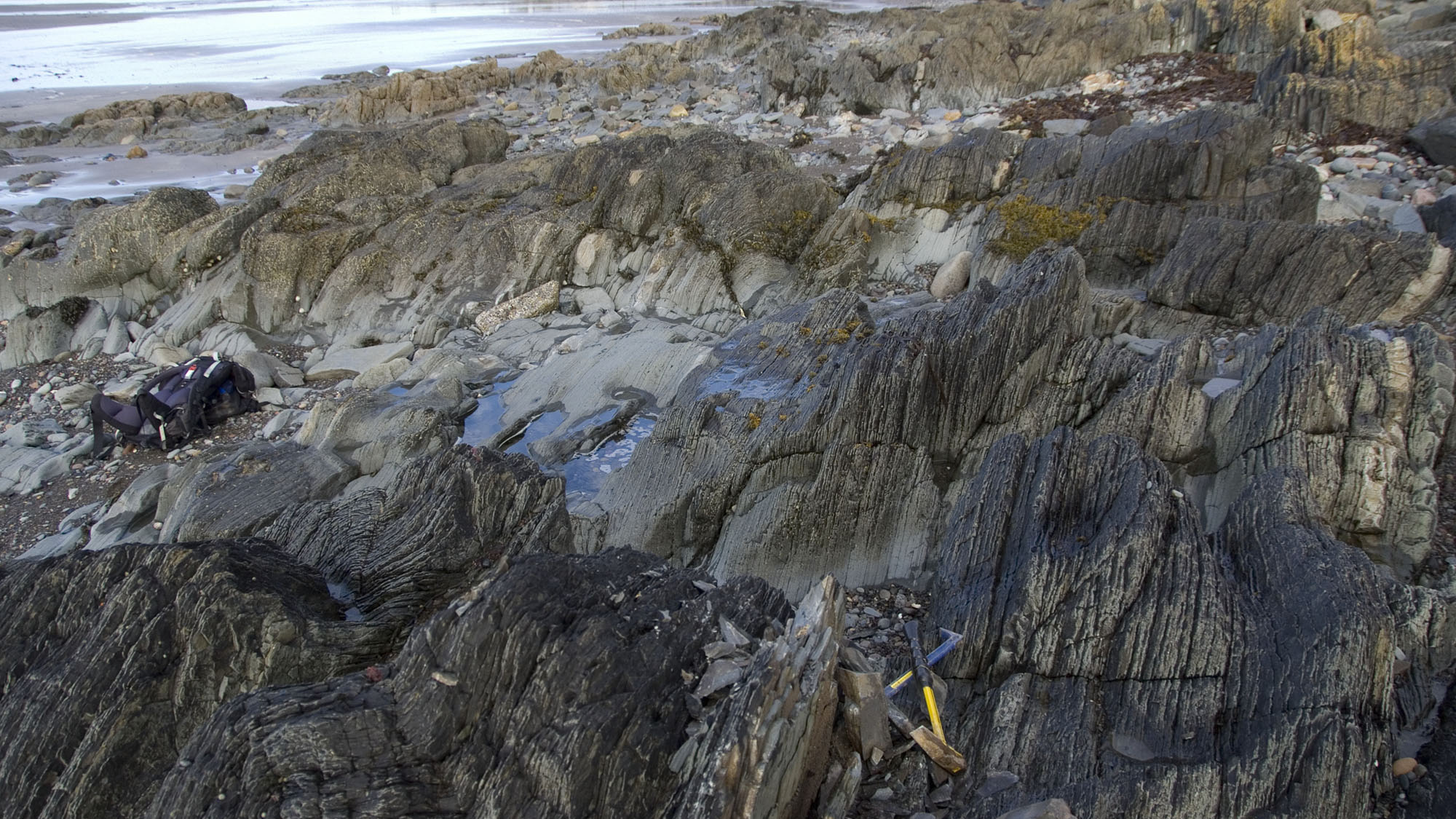
Overview
Directions
- Ardwell Bay lies beside the A77 south of Girvan, on the Ayrshire coast. This is the bay by Ardwell House and Ardwell Farm, not the similarly named bay in the Rhins of Galloway. The original guide records small lay-bys before and after the houses; a geological visit in August 2025 also approached the beach from a lay-by. Check the current signs and road conditions, park wholly clear of the carriageway and leave homes and farm accesses unobstructed.
- From the Ardwell House/Farm area, approach the shore and the dark, flaggy exposures towards the southern end of the bay. The cascade folds are a useful geological landmark. Do not cross the busy road or descend the embankment unless it is safe to do so. The outer foreshore is best examined near low tide, with a return route checked before setting out.
- Reference: 55.20455°N, 4.89966°W. This is the original guide’s locality reference, not a designated parking space.
Location photographs
Swipe to browse · Select a photograph to enlarge


Fossil Hunting
The most characteristic fossils documented from the Ardwell foreshore are graptolites and fragments of straight-shelled nautiloid cephalopods, usually called orthocones. They occur among thin sandstone, siltstone and dark mudstone beds of the Ardwell Farm Formation. The rocks may look almost black when weathered, but colour alone is unreliable when surfaces are wet, covered with algae or differently weathered. Follow the thin bedding and look at already exposed surfaces rather than treating every dark slab as fossil-rich.
Graptolites are small colonial animals commonly preserved as flattened, dark markings on fine-grained bedding surfaces. A hand lens and oblique light can help distinguish repeated branches or rows of tiny cups from irregular mineral stains and cracks. The fine mudstone partings are particularly worth observing. Published coastal accounts describe graptolites and orthocones as widely distributed but nowhere common, and the folded traverse can require patient searching. A visit may reveal excellent sedimentary structures without producing an identifiable fossil.
An orthocone fragment may show part of a straight, tapering shell and transverse partitions between its chambers. Weathering and breakage can leave only short sections, so record the whole visible surface and its scale before attempting an identification. Occasional brachiopods were recorded historically from the Ardwell Farm flagstones and shale partings. Trilobites also appear in the original locality account, but there is no basis here for promising common complete trilobites or identifying fragmentary finds to species without detailed examination.
A historical description opposite Ardwell Farm also records orthocone remains and brachiopods in sandy hollows on an eroded bedding surface above a disturbed interval. This is evidence for a particular shell-bearing horizon, not an indication that every breccia or nodule contains fossils. Its present exposure is not established. A distinct published graptolite horizon lies on the outer north-western foreshore of the bay, where the uppermost Ardwell shale is exposed only at low tide. Orthograptus and other diplograptid graptolites establish the Dicranograptus clingani Biozone. That record refers to a specific upper interval, rather than every folded bed at the southern end. The neighbouring Whitehouse succession carries different assemblages and should be treated as a separate extension of the geological walk.
Observation and photography should be the starting point at this protected site. Examine natural weathered surfaces without levering beds apart, and do not damage the folds, attached rock or coastal defences. Before removing even loose material, establish the current site rules and the appropriate landowner or mineral-right permissions. Where these remain uncertain, leave the specimen in place, photograph it with a scale and record its position. If collection is authorised, keep accurate provenance and both matching halves of any already detached fossil-bearing split; the geological context is an important part of the find.


Fossil photographs
Swipe to browse · Select a photograph to enlarge


Discoveries and milestones
Significant discoveries, geological research and conservation milestones at Ardwell Bay, in chronological order.
1882 – Ardwell established in the Girvan succession
Charles Lapworth’s account established the historical Ardwell subdivision within the Girvan succession. Later authors refined its boundaries and rank, but his work provided the foundation for describing and correlating the coastal rocks.
1899 – Survey description of the farm and bay
Ben Peach and John Horne described the Ardwell Farm flagstones, dark shale partings and recorded graptolites. Their memoir brought together Lapworth’s fossil observations and comparison of the upper beds with the Moffat succession; the fossil names and unit boundaries belong to the terminology of their time.
1935 – Sedimentary disturbances documented
S. M. K. Henderson investigated graded beds, breccias, sand injection and submarine disturbance along the Kennedy’s Pass–Ardwell coast. His thesis tabulated eleven lithological zones and described a specific disturbed interval opposite Ardwell Farm, providing detailed evidence for the behaviour of sediment before complete consolidation.
1959 – A tectonic structural model
Alwyn Williams published an interpretation involving an Ardwell fold phase followed by modification of fold-axis directions. The work made the spectacular coastal folds central to debate about the structural history of the Girvan district.
1962 – The regional stratigraphic framework refined
Williams’ monograph on the Barr and Lower Ardmillan succession refined the relationships and correlations used to place Ardwell within the Girvan sequence. Its regional framework helped distinguish lithological boundaries from fossil-based correlations.
1978 – A major slump-sheet interpretation developed
J. K. Ingham’s synthesis presented Bluck’s interpretation of the folded Ardwell sequence as a partly consolidated slump sheet. Sand movement around folds, a sandstone dyke and the confinement of the fold belt supplied key evidence. The synthesis also reconsidered the southern Kennedy’s Pass contact as a channel feature.
1979 – Flexural-slip folds analysed
Graham D. Williams and John G. Spray studied the Ardwell folds and bedding-plane slickensides. Their analysis offered a tectonic flexural-slip model in which originally non-planar bedding contributed to the three-dimensional fold shapes, providing an alternative to the large-slump interpretation.
1988 – Detailed coastal sedimentology published
Philip Stone and John Smellie’s geological account documented the thin turbidite rhythms, coarser event beds, injections, slump scars and breccias. It also set out the competing explanations of the cascade folds rather than treating the structural problem as resolved.
1988 – Farm-side organic microfossils investigated
Gillian M. Whelan’s palynological thesis recorded a dark-grey mudstone sample at the gate of Ardwell Farm, assigned to the top of the historical Ardwell Flags. Organic-walled microfossils, graptolite debris and other microscopic remains extended the documented fossil evidence, although the long-ranging chitinozoans offered little precise age control.
31 March 1989 – Notification date in the current SSSI register
The official record gives this notification date for the Girvan to Ballantrae Coast Section SSSI, which includes Ardwell. The date is the current register’s notification entry, not a claim that geological protection first began that year.
1992 – Fossil horizons separated in the excursion guide
Ingham’s field guide distinguished the folded Ardwell foreshore from the uppermost shale exposed on the outer north-western side of the bay at low tide. Graptolites in the upper shale established the Dicranograptus clingani Biozone, while the neighbouring Whitehouse localities were described separately.
2000 – National geological conservation assessment
The Geological Conservation Review assessed the Girvan foreshore’s importance, including the Ardwell type coast, its exceptional folds and its upper graptolitic shale. It recorded contrasting thickness estimates and explained the relationship to the younger northern succession.
2012 – Modern hierarchy and an unresolved fold origin
The BGS regional synthesis used the Ardwell Farm Formation within the Ardwell Subgroup and Ardmillan Group. It described the coastal box folds while explicitly noting that their proposed soft-sediment slump origin was not universally accepted.
30 March 2023 – Geological features monitored
NatureScot’s latest displayed monitoring visit recorded the SSSI’s geological features as favourable maintained. This assessment concerns the protected interest; it is not a confirmation of visitor access or permission to remove specimens.
2 August 2025 – The folds revisited in the field
A joint Glasgow and Edinburgh geological visit led by Neil Clark and Katie Strang examined the Ardwell folds and measured their axes. The published report recorded a prevailing fold-axis orientation of about 15° towards 065° and concluded that further evidence was needed to distinguish tectonic and slump explanations.
Geology
Ardwell’s thin, alternating beds accumulated beneath the sea during the Late Ordovician, on the Laurentian side of the Iapetus Ocean. Sediment-laden underwater currents carried sand and silt into deeper water; as each flow weakened, progressively finer material settled. Quieter intervals allowed mud to accumulate. Repetition of these processes produced the flaggy sandstone–siltstone rhythms and dark mudstone partings now visible on the shore. Graded layers, fine lamination and local load and flame structures preserve details of those depositional events.
The rocks belong to the Ardwell Farm Formation within the Ardwell Subgroup of the Ardmillan Group. Modern regional correlations place the formation across the Sandbian and early Katian stages, while graptolites from the uppermost low-tide shale constrain that particular coastal horizon to the Dicranograptus clingani Biozone. Older accounts use Caradoc terminology. These different descriptions concern different scales and parts of the succession; a single precise numerical age would conceal that distinction.
The famous cascade or box folds bend the thin beds into steep limbs alternating with lower-angle, corrugated limbs. Small slump scars, breccias and sand injections show that some deformation occurred while the sediments were still soft or partly consolidated. The origin of the entire cascade-fold belt remains debated: a major submarine slump sheet has been proposed, but tectonic flexural-slip models have also been developed. The secure evidence for small-scale slumping does not, by itself, settle the origin of every large fold.
Published thickness estimates for the complex Kennedy’s Pass–Ardwell coastal succession range from about 750 m to more than 1,200 m, while the BGS Lexicon gives about 1,000 m for the formation. These are not measurements of the height or uninterrupted thickness exposed at the bay. Folding, faults and changes in the historical definitions complicate comparison. Henderson’s separate 1935 coastal log totals 1,000 feet, not metres. The northern side of the bay leads towards the younger calcareous turbidites of the Whitehouse succession; this transition is useful context, but it is not a continuation of one uniform fossil bed.

Detailed geology and bed-by-bed succession
Detailed geology of Ardwell Bay: turbidite beds, fossil horizons, historical coastal zones and the cascade-fold debate.
The southern Ardwell Bay foreshore forms part of the classic Kennedy’s Pass–Ardwell coastal section. The account below separates the formation’s regional framework, features observed along that longer coast and the specifically located uppermost shale at the bay. Thin beds and disturbance horizons are described at their documented scale; they are not additional formal members or a complete measured vertical column.
ARDMILLAN GROUP
The Ardmillan Group contains the Ordovician marine succession above the Barr Group in the main Girvan outcrop. At Ardwell the relevant deposits are predominantly fine-grained turbiditic rocks, laid down by sediment gravity flows with intervening mud accumulation. The spelling Ardmillan is used in the modern hierarchy. The older names and subdivisions found in nineteenth- and early twentieth-century accounts do not always match present boundaries.
ARDWELL SUBGROUP
The Ardwell Farm Formation belongs to the Ardwell Subgroup. This rank places the bay’s rocks within the broader Girvan succession; it does not imply that every formation in the subgroup is exposed beside Ardwell House. The historical “Ardwell Group” or “Ardwell Flags” should be understood in the context of the author’s usage rather than added as a separate modern unit.
Ardwell Farm Formation
The type coast extends from Kennedy’s Pass to Ardwell Bay. Flaggy sandstone, siltstone and silty mudstone dominate, with local coarse sandstone, conglomeratic lenses and disturbed intervals. No formal member is established for this coastal section. The Plantinhead Member belongs to the Craighead succession and is not a name for the folded beds at this bay.
Age and fossil correlation. Modern regional work places the formation across the Sandbian and early Katian, within the Upper Ordovician. Traditional descriptions use Caradoc terminology, which is a regional framework rather than an exact synonym of one global stage. The uppermost foreshore shale has a Dicranograptus clingani Biozone fauna and belongs in the early Katian framework. That horizon-specific evidence is more precise than assigning the whole bay the age of a lower-formation sample from elsewhere.
Thickness and structural repetition. The BGS Lexicon gives about 1,000 m for the formation, while the 1988 coastal account records at least 750 m. The Geological Conservation Review contrasts an approximately 750 m coastal estimate with Ingham’s estimate of more than 1,200 m, alongside agreement on about 1,400 m inland. These figures concern differently interpreted, structurally complex successions. None is an uninterrupted measured thickness visible at Ardwell Bay, and none can be substituted for the 1,000 feet total of Henderson’s historical coastal log.
Southern basal contact at Kennedy’s Pass. At the southern end of the type coast, near NX 1490 9330, flaggy beds occupy a shallow, irregular channel cut into the Kilranny Conglomerate. Small recesses beneath overhanging conglomerate form part of the contact geometry. Henderson’s historical “unconformity” interpretation and the earlier use of Benan terminology were refined by later work. This is adjacent type-section context, not a basal bed exposed beneath every photograph of the bay.
Lower coastal siltstone and mudstone facies. Near the base of the southern type coast, dark green-grey siltstone and silty mudstone contain numerous millimetre-scale fine sandstone laminae. Thin medium-grained sandstone beds are less frequent, and lenses of coarse sandstone or pebble conglomerate occur locally. Small faults may contain sand injected back from adjacent sediment. These features record variable flow strength and instability in wet sediment, rather than a separate named member.
Thin sandstone–siltstone rhythms. Much of the folded foreshore consists of alternations about 1–15 cm thick, with medium- to fine-grained sandstone, siltstone and occasional black mudstone drapes. Normal grading records declining flow energy. Load and flame structures developed where sediment layers deformed against one another, while parallel and cross-lamination preserve current activity. The 1988 account describes predominantly incomplete Bouma sequences, using the terms Tbce, Tce and probably Tde: these identify sedimentary divisions within turbidites, not formal stratigraphic beds.
Isolated coarse event beds and back-injection. Coarser sandstone beds reach about 75 cm locally and may contain ripped-up mudflakes. Some preserve more complete graded and laminated turbidite successions, described as Ta–e or base-absent Tb–e. In places the current disturbed and fractured the underlying fine-grained beds through about 10–15 cm, allowing coarse sandy or gravelly sediment to enter the fractures. Both measurements describe individual events along the coast, not uniform intervals extending through the whole bay.
Slump scars and intraformational breccias. Angular siltstone fragments and rounded carbonate concretions may be enclosed in a coarse sandy matrix. Larger collapse breccias contain jumbled blocks of the thin flaggy beds, locally with little or no matrix. Published examples form lenses up to about 6 m thick and can be followed for 60 m or more. Sharply defined, curved or stepped slump scars are overlapped by younger beds; carbonate cement and the relationship to those younger layers support a synsedimentary origin. These deposits are discontinuous disturbances, not a laterally uniform “breccia member”.
The cascade-fold debate. Steep, comparatively planar limbs alternate with lower-angle corrugated limbs in overlapping, non-cylindrical folds. Slip between beds is an important part of their geometry. Alwyn Williams’ 1959 model invoked an early fold phase followed by modification of fold-axis directions. Williams and Spray’s 1979 analysis instead developed a flexural-slip interpretation involving initially non-planar bedding and bedding-plane slickensides. Bluck’s alternative, presented in Ingham’s 1978 synthesis, emphasised sand movement at fold closures, an axial-plane sandstone dyke and stratigraphic confinement as evidence for a large partly consolidated slump sheet. Although the conservation synthesis favours slumping, the 2012 BGS account retains the disagreement, and the 2025 field report calls for more evidence. Small soft-sediment disturbances are secure; the mechanism of the whole fold train remains open.
Historical log: scope and units. Henderson’s 1935 Table II divides the longer Kennedy’s Pass–Ardwell coast into eleven numbered lithological zones totalling 1,000 feet. They alternate between shale-dominant and sandstone-dominant packages. These are historical descriptive divisions, not modern formal beds, not biozones and not a measured log of the bay alone. The table separates Zone 11 from Zone 10 by a historical unconformity; that interpretation must not be confused with the modern northern subgroup contact. The following figures retain the original feet and inches, and “average bed” describes the tabulated mud-plus-sand couplet rather than every bed in the zone.
Henderson Zone 1. 150 feet, shale-dominant; the average bed comprises 2 inches of mud and 1 inch of sand, with a 6-foot interval of slipping and sand injection.
Henderson Zone 2. 80 feet, sandstone-dominant; the average bed comprises 1 inch of mud and 4 inches of sand, with 4-foot and 3-foot grit or breccia intervals.
Henderson Zone 3. 50 feet, shale-dominant; the average bed comprises 2 inches of mud and half an inch of sand, with no disturbance interval tabulated.
Henderson Zone 4. 70 feet, sandstone-dominant; the average bed comprises 1 inch of mud and 2 inches of sand, with no disturbance interval tabulated.
Henderson Zone 5. 30 feet, shale-dominant; the average bed comprises 1 foot of mud and 6 inches of sand, with breccias 5, 8, 7 and 4 inches thick.
Henderson Zone 6. 60 feet, sandstone-dominant; the average bed comprises 1 inch of mud and 3 inches of sand, with no disturbance interval tabulated.
Henderson Zone 7. 70 feet, shale-dominant; the average bed comprises three-quarters of an inch of mud and a quarter of an inch of sand, with no disturbance interval tabulated.
Henderson Zone 8. 80 feet, sandstone-dominant; the average bed comprises half an inch of mud and 3 inches of sand, with 14 feet of conglomerate and 6 feet of breccia.
Henderson Zone 9. 90 feet, shale-dominant; the average bed comprises 2 inches of mud and 1 inch of sand, with 2-foot and 1-foot breccia or sand-injection intervals.
Henderson Zone 10. 120 feet, sandstone-dominant; the average bed comprises half an inch of mud and 2½ inches of sand, with two 1-foot breccia or sand-injection intervals.
Henderson Zone 11. 200 feet, shale-dominant; the average bed comprises 3 inches of mud and 1 inch of sand, with 20-, 50-, 4- and 2-foot landslip or breccia intervals.
Historical calcareous horizons. Henderson described limy greywacke passing into black or grey shale within Zone 7. In the upper part of Zone 9, calcareous concretions form conspicuous horizons and can join together. These lithological observations add detail to the old log without establishing modern member names or a fossil content for every nodule.
Henderson’s Locality 10, opposite Ardwell Farm. This separately numbered observation site is an exact farm-side locality, not the same thing as Zone 10. Henderson recorded disturbed beds above sandy greywacke containing limy nodules, with sand injection and slump folding. The disturbance reached about 4 feet in thickness over roughly 50 feet along strike. These are historical observations of a particular exposure, not a guarantee of its present condition or accessibility.
Historical fossil-bearing erosion surface above Locality 10. A few feet above the folding zone, and separated from it by normally bedded sediment, Henderson described an eroded surface with hollows partly or wholly filled by sand. These contained orthocone remains, recorded under the historical name Orthoceras, and some brachiopods. The observation documents a distinct shell-bearing erosional horizon opposite Ardwell Farm, rather than a fossil content for every slump breccia. Its precise modern bed assignment and present exposure have not been established, and Henderson’s proposed earthquake and tsunami explanation is a historical interpretation rather than a demonstrated cause.
Uppermost Ardwell shale on the outer foreshore. Ingham’s Locality 3 lies on the north-western side of the bay near NX 158 943. Dark shale and evenly bedded sandstone occur between branches of a fault, and the useful exposure is accessible only at low tide. Orthograptus and other diplograptids indicate the Dicranograptus clingani Biozone. A biozone is a fossil-based time correlation rather than another lithological member, and its name does not identify an unexamined specimen as the index species.
Historical farm-gate mudstone sample MV/G/7. Gillian M. Whelan’s 1988 palynological thesis records a dark-grey mudstone sample at the gate of Ardwell Farm and describes it as coming from the top of the historical Ardwell Flags. The sample contained organic-walled microfossils, scolecodonts, graptolite debris and organic tubes. Reported chitinozoans included Belonechitina micracantha, Conochitina conulus and Cyathochitina campanulaeformis; these are the thesis identifications, not new determinations of shore specimens. Their long ranges provided little precise age control. The published farm-gate description does not establish an exact modern shore coordinate or a correlation with Ingham’s outer-foreshore Locality 3. This research sample should therefore remain distinct from both that graptolite horizon and the inland Pinmerry samples.
WHITEHOUSE SUBGROUP — ADJACENT NORTHERN CONTEXT
South Shore Formation
On the north side of the bay, the transition towards the Whitehouse shore introduces thicker, gravelly calcareous turbidites. The first prominent calcareous bed contains reworked Ardwell material and is used in coastal accounts to mark the start of the South Shore Formation. The conservation account gives about 75 m for that formation in the adjacent succession. The BGS Lexicon also records an unseen or faulted upper boundary for the Ardwell Farm Formation, so a single continuously exposed, undisturbed contact should not be assumed. The South Shore beds and the younger Whitehouse formations are distinct from the southern Ardwell collecting focus.
Regional samples and correlations. The approximately 1 m interval sampled for ostracods and chitinozoans at inland Pinmerry belongs to the lower Ardwell Farm Formation and supports a Sandbian age. It is not a sample from this bay, and its six-species ostracod assemblage must not be transferred to the shore. The proposed correlation with the Penwhapple “Cascade beds” likewise does not make those inland names local bay beds. A preliminary 2017 chitinozoan report included one Ardwell Formation sample without establishing an exact bay position in the available account. The later Whitehouse study appeared online on 14 May 2026 in an issue labelled 2025; its regional linearis-zone correlations do not replace the older clingani-zone evidence from the upper Ardwell foreshore.
References
Whelan (1988): The palynology of selected Ordovician localities in Scotland, pp. 63 and 295
BGS Lexicon: Ardwell Farm Formation
Stone and Smellie (1988): Geology of the Ballantrae district
Ingham (1992): Girvan Foreshore
Rushton and colleagues (2000): Girvan Foreshore, Geological Conservation Review 18
BGS (2012): South of Scotland regional geology
Henderson (1935): thesis, Table II and Ardwell Farm locality
Williams and Spray (1979): non-cylindrical flexural-slip folding
Mohibullah and colleagues (2011): inland lower Ardwell ostracods
Molyneux and colleagues (2023): modern Ordovician synthesis
Geological Society of Glasgow (2025): Ardwell field visit
Lissens and colleagues (online 2026; issue dated 2025): Whitehouse chitinozoans
Safety
Check the tide, weather and sea conditions before visiting. The uppermost outer-foreshore shale is exposed only at low tide, and rising water or swell can obstruct a return route. Do not rely on being able to climb the embankment or on the old assurance that tidal cut-off is impossible. Turn back early if the route is becoming wet or wave-washed.
Tilted bedding, loose stones and wet or seaweed-covered surfaces are slippery and awkward to cross. Wear grippy footwear, keep well away from unstable rock and avoid scrambling over the folds. The A77 is a major additional hazard: keep people and equipment clear of traffic, supervise children closely and do not assume a lay-by provides a safe road crossing.
Equipment
Take sturdy footwear, suitable weatherproof clothing, a hand lens, camera, scale and notebook. A tide prediction and a means of calling for help are important, although reception should not be assumed. These are sufficient for an observation visit; hammers, chisels and pry bars are not a substitute for permission and should not be used to open attached beds. Any separately authorised scientific sampling must follow its agreed conditions and appropriate eye protection.
Cleaning And Treating
For any specimen legally collected with permission, begin with photographs and a full locality record. Keep delicate shale surfaces and matching counterparts supported during transport. Avoid vigorous brushing or scraping: graptolites may survive as very thin surface films, and a fossil can be removed with the weathered surface that carries it.
Do not soak friable shale or apply acid, bleach, varnish or consolidant without first identifying the matrix and obtaining suitable conservation advice. Gentle dry examination is usually the safest first step. Stop if the surface flakes or a film begins to lift; careful storage and expert preparation may preserve far more information than an attempt to make the specimen look cleaner.
Identify Your Finds
Need help identifying a fossil? Share clear photos, where you found it and its size with the community.
Further Reading
Deposits Magazine: Geological expedition along the southwest coast of Scotland
Ingham: Girvan Foreshore excursion
Geological Conservation Review: Girvan Foreshore
BGS: Geology of the Ballantrae district
BGS Lexicon: Ardwell Farm Formation
Henderson: The sedimentary and tectonic history of certain Lower Palaeozoic rocks (1935)
Geological Society of Glasgow: 2025 Ardwell field visit
NatureScot: Girvan to Ballantrae Coast Section SSSI
NatureScot: Scottish Fossil Code
Access Rights
Ardwell forms part of the Girvan to Ballantrae Coast Section SSSI. Its geological exposures are protected, and the national importance of the folds and fossil-bearing succession makes avoiding damage especially important. Walking access does not include an automatic right to extract or remove fossils.
Before collecting, check the current site guidance and obtain the relevant landowner or mineral-right-holder permission. Extraction from bedrock within an SSSI requires NatureScot consent, and loose material may also be subject to controls. The necessary consent route does not replace ownership permission. No blanket collecting permission is established by this guide; if the applicable rules are uncertain, leave material in place and seek advice. Do not hammer, chisel or pry attached beds, damage the folds or undermine banks and structures.
 Scotland’s fossil resource is at risk of abuse and damage, and so we must all safeguard and manage fossil collecting to ensure its survival for future generations. For this reason it is VITAL you read and adhere to the Scottish Fossil Code for ALL sites in Scotland.
It is important to follow our Code of Conduct when collecting fossils or visiting any site. Please also read our Terms and Conditions.
Links
♦ Fossil Discussions
♦ Fossil Articles
♦ Buy Fossils, Tools and Equipment
♦ Buy Crystals, Meteorites, and Artefacts
♦ Join Fossil Hunts
♦ UK Fossils Network


