
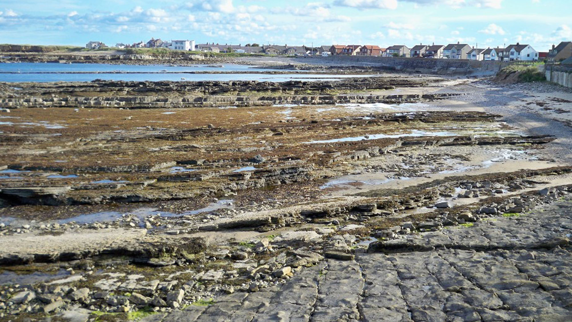
Overview
Directions
- Reach Beadnell on the B1340 and follow the village roads towards Harbour Road. The council car park provides an established parking option; check its current signs and terms rather than relying on old roadside spaces.
- The council’s September 2026 listing gives one hour free, three hours £7 and all day £9.50, with PayByPhone location 804135. These terms apply to the listed council car park, not every space along Harbour Road.
- Walk along Harbour Road and use an open public access point to the village foreshore. The previously described approach followed the southern edge of a large field beside this road; use that route only where it remains a lawful, open shore access, without crossing fences or private ground.
- The harbour-area reference is 55.55074°N, 1.62513°W. It is an orientation point, not the location of every fossil bed. Red Brae/Dell Point lies farther north; Blyth Rocks, Nacker Hole and Lady’s Hole form separate village-shore exposures, while Ebb’s Nook and the harbour breakwater expose younger limestone.
- Allow time to explore and return on a falling tide. Choose a route that keeps access to the village open, and leave low reefs before incoming water isolates them.
Location photographs
Swipe to browse · Select a photograph to enlarge


Fossil Hunting
The contrast between hard limestone and softer shale is the key to Beadnell. Limestone reefs and loose cobbles commonly show pale fossil sections against a darker matrix, especially in oblique light or on naturally damp surfaces. Crinoid stems appear as discs, rings and short segmented rods, while corals show repeated internal partitions. The shale can preserve far more complete shells, but its fossil-rich layers are localised. Observe the exposed reefs and naturally weathered blocks before assuming that an apparently similar rock belongs to the same bed.
At Red Brae and Dell Point, north of the harbour, the Eelwell Limestone and its overlying mudstone have a particularly well-documented fauna. The dark, calcareous mudstone above the limestone contains brachiopods recorded as Eomarginifera and Spirifer. Shell-packed slabs in the photographs illustrate the type of preservation that makes this shore rewarding, but the harbour reference should not be used as a precise coordinate for that northern fossil horizon. Record where a slab actually lies and whether it was attached to a bed or loose.
Dell Point’s upper Eelwell limestone also contains bryozoans, colonial animals whose remains may resemble delicate mesh, branching twigs or encrusting patches. Billing recorded Hyphasmopora buskii, several Fenestella species, Penniretepora flexicarinata, Synocladia, Tabulipora and Sulcoretepora parallela. These are specialist historical identifications from the named station. A hand lens may reveal the fine repeated openings in a colony, but a weathered fragment rarely supports a confident species name without comparison or preparation.
Lady’s Hole has a different bryozoan assemblage in shale partings within the Sandbanks, or Four Fathom, Limestone. The published sample is rich in fragmented rhabdomesids, including Rhabdomeson gracilis and R. rhombifera, with Rhombopora, Polyfenestella and other forms. Brachiopod fragments accompany them. These shale partings should not be confused with the separate mudstone above the Eelwell at Dell Point, even though both contain marine fossils.
The Great Limestone at the harbour and Ebb’s Nook is younger again. A historical account records a compound-coral band about 3 ft above its base, including corals called Lonsdaleia. That record does not justify attaching the full fauna of another Great Limestone locality to Beadnell. On the sandier, pebbly parts of the shore, rounded limestone cobbles may expose crinoids and corals, but wave transport can separate a cobble from its original bed. Keep the find position and uncertainty with the specimen record.
Concentrate on photography and non-destructive observation. Do not split reefs, dig into shale bands or remove attached colonies; obtain the relevant permission before taking loose material. Thin shale and finely branching bryozoans are easily damaged by forcing a split, and large fossil-rich blocks are often best left for others to see. Photograph unusually complete shells, delicate colonies and trace-bearing surfaces with a scale and seek specialist advice before preparation. The detailed geology retains the exact-station faunal lists and historical names without making every record a routine visitor find.
Fossil photographs
Swipe to browse · Select a photograph to enlarge
Discoveries and milestones
Significant discoveries, geological research and conservation milestones at Beadnell.
February 1859 – The Beadnell shore and its fossil traces described
George Tate published an account of Beadnell’s geology, including fossil traces described historically as annelids. The publication belongs to 1859; its later digital availability is not a new discovery date.
1893 – The village succession and structural repetition recorded
Edmund Garwood described the shore northwards from Ebb’s Nook, recognising the major limestone intervals, their intervening beds and structural repetition. His historical names remain useful only when tied to the places he described.
1900 – District Geological Survey account published
Gunn’s memoir on Belford, Holy Island and the Farne Islands provided a regional mapping framework for the Beadnell succession. It forms part of the geological survey history rather than the discovery of one new fossil.
1927 – The harbour coral band recorded in revised survey work
The revised Geological Survey account recorded a compound-coral band near the base of the Great Limestone at Beadnell harbour. Later work retained this as an exact harbour observation within the wider limestone correlation.
1965 – The Great Limestone placed in wider depositional context
Hodge’s Great Cyclothem study discussed the Beadnell harbour coral band alongside regional variations in the Great Limestone. The wider thickness comparisons do not constitute a newly measured harbour log.
1981 – Coastal limestone ages studied with foraminifera
Strank studied foraminifera from the Beadnell and Spittal sections. Later accounts report that this work assigned the Beadnell Budle and thin limestones to the early Brigantian, and Eelwell and Acre to the late Brigantian. These remain historical correlations, distinct from later revisions.
October 1990 – Coastal folds, thrusts and the dyke mapped
Bower examined the Beadnell structural stations, distinguishing folded limestones, thrust movements, pressure-solution features and later strike-slip faults. Relationships with the dolerite dyke helped separate phases of deformation.
1991 – Dell Point and Lady’s Hole bryozoans documented
Billing recorded distinct fossil assemblages at Dell Point and Lady’s Hole, including detailed specimen descriptions. The study kept the Eelwell limestone fauna separate from the Sandbanks shale-parting assemblage.
11 December 1992 – Northumberland Shore SSSI notified
The protected Northumberland Shore site included parts of the village foreshore for their coastal bird-habitat interests. Its intertidal boundary and collecting permissions remain separate matters.
2020 – Limestone correlations tested with microfossils
Cózar and Somerville used coastal foraminiferal assemblages, including material from the Beadnell section, to refine limestone correlations. Their results distinguish newer Budle and Bath-House Wood interpretations from some older local naming schemes.
Geology
The village shoreline exposes limestone-bearing cycles of the Alston Formation in the Yoredale Group. The main named markers include Eelwell, Acre or Three Yard, Sandbanks or Four Fathom, and Great or Dryburn limestones. They do not form one neatly measured cliff beside the harbour pin. The reefs are folded, faulted and exposed at different places, so a walk along the coast intersects and sometimes repeats different parts of the succession.
The limestones record periods when marine conditions spread over the region. Crinoids, brachiopods, corals and bryozoans lived in these seas, leaving skeletal material in carbonate sediment. Mud and sand deposited between the limestone intervals record changing sediment supply and shallowing conditions. At Dell Point, a thin calcareous mudstone above the Eelwell contains concentrated brachiopods; its possible storm-deposit interpretation comes from comparison of the bed along the coast and should not be inferred solely from the number of shells.
Farther south, shale partings separate limestone posts in the Four Fathom Member at Lady’s Hole. These partings preserve fragmented bryozoans and a different local fossil association from the upper Eelwell beds. At the harbour and Ebb’s Nook, the Great Limestone is a higher marker near the top of the Alston Formation. It is Pendleian in the traditional scheme, within the Serpukhovian, whereas the lower principal members are Brigantian. The entire village shore therefore cannot accurately be given one Viséan or approximately 330-million-year age.
The structures are especially clear in the reefs. At Red Brae, the Eelwell is folded and locally thrust along shale partings, whereas overlying laminated shale and fine sandstone have broader, gentler warps. Around Blyth Rocks and Nacker Hole, close folds, reverse movements, pressure-solution seams and later strike-slip faults record several stages of deformation. Their spacing and displacement measure structures; they are not the thicknesses of fossil beds. The Great Limestone at Ebb’s Nook is comparatively little folded in the detailed structural study.
The Beadnell dolerite dyke cuts through the limestone and intervening clastic rocks. Branches of the intrusion and faults that offset it help establish the relative order of igneous intrusion and later movement. It belongs to a separate geological event rather than the marine sedimentary hierarchy. Coal-bearing beds described beneath the Red Brae limestone link the coastal succession to Beadnell’s former mining history, but mine records and seam names should not be used to manufacture a present-day shore log.
Historical terminology adds another complication. Garwood used Beadnell or North Sunderland Limestone for the Red Brae bed now identified here as Eelwell, and called the Blyth Rocks limestone Six-yard. Those names must be tied to their stated exposures: “Beadnell Limestone” has also been used differently elsewhere. More recent microfossil work revises correlations between the Beadnell and Spittal sections. The expanded account separates those schemes and nearby northern comparisons, preserving uncertainty where a complete local measured bed sequence is unavailable.
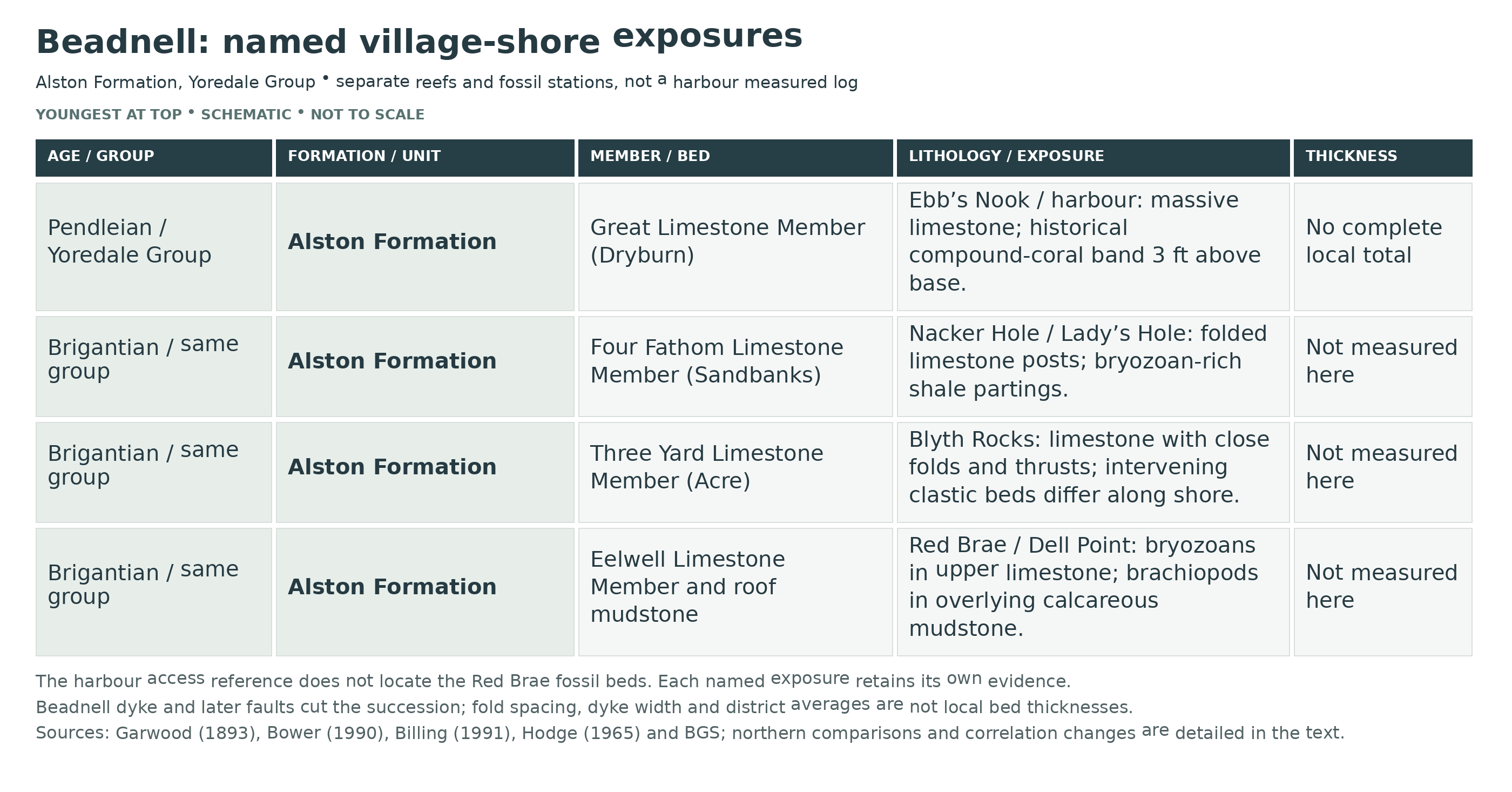
Detailed geology and bed-by-bed succession
Detailed geology: separate Beadnell shore exposures, fossil horizons, structural evidence and qualified historical correlations.
The village shore contains several named exposures rather than one continuously measured section at the harbour reference. Red Brae/Dell Point lies to the north, Blyth Rocks and Nacker Hole occupy another stretch, Lady’s Hole is a separate fossil station, and Ebb’s Nook and the harbour natural breakwater expose the Great Limestone. Original photographs show tilted reefs and fossil-rich shale but do not fix the old field entrance to one surveyed bed. The northern Annstead comparison is identified separately, and no nearby mainland section is silently substituted for the village shore.
YOREDALE GROUP
Alston Formation
Marine limestone cycles alternate with shale, sandstone and locally coal-bearing beds. The principal Eelwell, Three Yard and Four Fathom members are Brigantian; the higher Great Limestone is Pendleian and marks the top of the Alston Formation. Thus the village succession extends beyond a single Viséan age assignment. Named structural stations in historical studies are not bed numbers, and fold dimensions or regional averages are not local bed thicknesses.
Eelwell Limestone Member: Red Brae and Dell Point
Eelwell limestone at NU 2366 2938–NU 237 294. Grey fossiliferous biomicrite has upper, buff-weathering levels particularly rich in bryozoans. Garwood’s 1893 account called the limestone at this place Beadnell or North Sunderland Limestone and gave a district-average figure of 24 ft. That historical average is not a modern measurement of the complete present Red Brae exposure, and the historical name cannot be equated with every “Beadnell Limestone” in other accounts.
Red Brae limestone structure. Bower describes open cylindrical folds with spacing of approximately 5–15 m, amplitudes around 2 m and southward plunges of 6–8°. East- to east-north-east-directed intrabed thrusts detach into shale partings. Cross-cutting and anastomosing strike-slip faults, together with calcite-filled tension-gash veins, record additional deformation. These values describe structures. The original printed account gives strike-slip displacement generally less than 2 m and fault traces persisting over 5 m; displacement and trace length are different measurements. Figure 91 independently captions a photographed displacement of less than 2 m.
Upper Eelwell posts at Dell Point. Several limestone posts were sampled separately, but Billing found no consistent vertical change in bryozoan composition. The exact-station list comprises Hyphasmopora buskii, Fenestella multispinosa, F. tuberculo-carinata, F. plebeia, Penniretepora flexicarinata, Synocladia sp., Tabulipora sp. and Sulcoretepora parallela. The illustrated Synocladia fragment DP 11 is a documented specimen, not a newly named species. The four separate Snook Point post assemblages are not imported into this station.
Brachiopod-rich mudstone above Eelwell. A relatively thin, dark grey calcareous mudstone contains abundant Eomarginifera and Spirifer in Billing’s account. Garwood used the historical names Producta longispina and Spirifera trigonalis for Red Brae shale fossils; these are not silently treated as one-to-one modern synonyms of Billing’s determinations. A storm-deposit interpretation was suggested using the bed’s continuity towards Snook Point. Fossil abundance alone does not prove that interpretation, and no exact local thickness is assigned.
Laminated shale and fine sandstone above Red Brae. The overlying clastic beds are gently warped into two north–south anticlines. They have wider spacing and lower amplitude than the limestone folds below, and Bower did not record equivalent thrusting in this interval. No bed-by-bed thicknesses are available.
Historical coal-bearing beds beneath Red Brae. Garwood described workable coal seams below the local limestone. This is a historical geological and mining observation, not present mine-access guidance. No reliable exact shore-seam thickness is supplied, and values from inland workings are not substituted.
Three Yard Limestone Member: Acre at Blyth Rocks
Blyth or Blythe Rocks, Benthall and Nacker Hole. The limestone around NU 2360 2902 is the Acre, formally Three Yard, Member. Garwood called the bed at this station Six-yard. Bower recorded closely spaced open folds, approximately 2–5 m apart, with gentle southward plunges and thrust offsets of around 0.5–1 m. These are fold spacings and displacements, not an exact member thickness.
Ironstone-bearing black shale below Sandbanks. Garwood described black shale containing ironstone nodules on the northward, descending traverse. He compared it with the Brinkburn ironstone-bearing beds; that is a historical correlation, not a demonstrated new member or a measured local thickness.
Four Fathom Limestone Member: Sandbanks at Nacker Hole and Lady’s Hole
Sandbanks limestone posts. The historical Eight-yard limestone corresponds here to the Sandbanks or Four Fathom Member. Several limestone posts are separated by shale. Billing’s 7–11 m range is regional and is not reported as the measured thickness of Lady’s Hole at NU 238 288.
Fossiliferous shale partings at Lady’s Hole. The shale samples are dominated by rhabdomesid bryozoans and fragmented colonies. Billing recorded Rhabdomeson gracilis, R. rhombifera, Rhombopora bancrofti, R. incrassata, Polyfenestella fenestelliformis, an indeterminate trepostome and Sulcoretepora parallela, together with brachiopod fragments. Specimen LH 4 of Polyfenestella was described in detail. These historical determinations belong to Lady’s Hole; neither numbered partings nor individual parting thicknesses were recovered.
Folded and thrust limestone posts at Nacker Hole. Folds with north-north-east to north-east axes and slight southward plunges reach amplitudes of about 1.5 m. Reverse displacements reach around 1.2 m. Vertical stylolites predate the thrusts, while later strike-slip movement offsets fold axes by up to 2 m and cuts the dyke. These relationships record distinct deformation stages rather than a single event or measured sedimentary thickness.
Intervening clastic beds towards Ebb’s Nook. Shale and sandstone occur below the Great Limestone and above the Sandbanks on Garwood’s coastal traverse. Their position is useful, but no complete measured local subdivision was recovered, so unnamed beds and numerical thicknesses are not invented.
Great Limestone Member: Ebb’s Nook and the harbour
Great or Dryburn limestone at NU 239 287. Massive fossiliferous limestone forms the harbour’s natural breakwater and Ebb’s Nook. Garwood recorded a south-east dip of around 8–10°; Bower found relatively little folding here compared with the northern reefs. The member is Pendleian, within the Serpukhovian, and lies at the top of the Alston Formation. Its exact complete present-day harbour thickness was not recovered.
Historical compound-coral band. Hodge explicitly cites the 1927 Geological Survey account of Lonsdaleia and other compound corals in a band approximately 3 ft above the limestone base at Beadnell harbour. This is a historical generic identification. It does not establish a modern species assignment or justify adding the Chaetetes, Calcifolium or Frosterley assemblages of other Great Limestone localities.
Nacker Hole mapped thin coal. Figure 90 marks a poorly exposed thin coal beside the road and wall. It has no printed measured thickness or verified named-seam correlation and is retained as a separate mapped observation.
Mapped cross-bedded sandstone beside the dyke. A medium-grained, cross-bedded sandstone is labelled between the Acre and Sandbanks exposures in Figure 90. It is a separately mapped clastic horizon; no numerical thickness is inferred.
Later intrusion and faulting. The igneous body cuts across the sedimentary succession and is treated separately from its members.
Beadnell dolerite dyke. The intrusion crosses the Acre and Sandbanks limestones and intervening clastic beds near Nacker Hole. Garwood’s average width was 25 ft, a historical dyke measurement rather than sediment thickness. Bower records branches or apophyses, folded limestone beside the intrusion and later faults that offset it.
Northern extension: Annstead and north Beadnell. These are separately identified comparison exposures, not beds demonstrated at the harbour pin. The following observations preserve their own locality and historical terminology.
Oxford Limestone at Annstead Rocks. Bower recorded four gently deformed open anticlines, with minor bed thrusts of less than 1 m displacement. Neither the fold count nor the displacement is a limestone-thickness log.
Unnamed thick limestone above Oxford. The higher carbonate shows weak, broad north–south flexing, without comparable folding and thrusting in the study. It is retained as an unnamed observed unit.
Historical Budle/Colwell limestone at north Beadnell. At structural station 52, NU 2326 2970, fault splays slice the limestone and interleave it with clastic rocks. A local anticline and strike-slip structures are recorded. Station 52 is a map locality, not Bed 52, and the older Budle/Colwell naming is not silently substituted into the revised microfaunal scheme below.
Lower unnamed thin limestone above the Budle interval. Bower recorded this as one of two distinct thin carbonate horizons. It was neither folded nor thrust in the described exposure; no member name or measured thickness is assigned.
Upper unnamed thin limestone. A second separate thin carbonate is also recorded without equivalent folding or thrusting. It is not merged with the lower horizon or given an invented formal name.
Thin coal and erosive sandstone lenses. Lens-shaped sandstone locally removes the coal. A later dextral strike-slip fault displaces the erosion surface, providing a relative sequence of deposition, erosion and deformation. No exact coal or sandstone thickness is given.
Regional Great Limestone comparison, not a harbour log. The following historical figures describe a wider coastal interval and remain outside the exact village measured evidence.
Historical Tumbler Beds. For the broader Embleton–Beadnell area, Hodge cites approximately 27 ft of massive limestone and around 20 ft of shaly and thin-limestone Tumbler Beds, with a stated total of 48 ft. The slight mismatch between the rounded components and total is retained rather than corrected by inventing a missing bed. These figures are not a measured present harbour column.
Microfossils and revised correlations: section-level evidence. Cózar and Somerville’s 2020 study uses thin-section microfauna to compare Beadnell, Spittal and other Northumberland sections. Its combined assemblages cannot be treated as a species list for every named beach bed. The sample-to-place supplement was not available for this account, so individual sample codes below remain attached to the published combined result rather than a guessed visitor station.
Oxford Limestone: combined Spittal–Beadnell record. The paper explicitly states that samples were productive in both sections. The combined assemblage includes Neoarchaediscus, Archaediscus at the angulatus stage, Howchinia gibba, rare H. longa, Falsocalcifolium punctatum and transitional Endothyranopsis crassa–E. sphaerica. The interpretation is upper early Brigantian, assemblage 6. This does not place every taxon in an individually identified Annstead bed.
Budle Limestone: revised Beadnell correlation. The 2020 paper identifies Budle as the third limestone above Oxford in its Beadnell section, records Asteroarchaediscus pustulus and correlates it with Lower Bath-House Wood at Spittal. This differs from older Colwell/Budle equivalences. Its scheme is retained separately rather than relabelling each old mapped bed.
Middle Bath-House Wood: separately named regional interval. The coastal study records Asteroarchaediscus bashkiricus and an unnamed new Praeostaffellina form. The exact sample station remains unresolved here; Middle Bath-House Wood is not assumed to mean one of the older Upper Bath-House Wood leaves.
Upper Bath-House Wood: combined coastal samples. The account records Archaediscus transitional from angulatus to tenuis stage and “Millerella” tortula, with sample Pc3606 illustrated. No exact Beadnell bed occurrence is inferred solely from the combined heading.
Shotto Wood: combined coastal samples. Janischewskina brigantiensis and Eostaffella mirifica, including illustrated sample Pc3607, support a late Brigantian assemblage 7 interpretation. Their precise local sample position is not established in this guide.
Eelwell: revised regional correlation. The study correlates Eelwell with the Five Yard Limestone rather than relying on the older Scar equivalence. Combined coastal records include Endothyranopsis sphaerica, Climacammina, Janischewskina typica, “Millerella” tortula, Eostaffella mirifica, an unnamed Praeostaffellina, Biseriella parva, Endothyranopsis plana and Howchinia with umbilical structures. Illustrated samples Pc3572, Pc3578, Pc3583 and Pc3568 are not assigned to Dell Point without the missing sample matrix.
Acre: combined Spittal, Beadnell and Boulmer evidence. Neoarchaediscus postrugosus, Eostaffellina decurta, Eostaffellina ex gr. paraprotvae, Eostaffella ex gr. pseudostruvei, Calcifolium okense, Eostaffellina ? sp. and Endothyranopsis sphaerica support the Three Yard correlation and assemblage 8. Samples Pc3556 and Pc3587 are illustrated, but the pooled result is not a complete species list for each of the three sections.
Sandbanks: combined coastal evidence. The Four Fathom correlation and assemblage 9 interpretation use Eostaffellina paraprotvae, Eostaffella pseudostruvei, Archaediscus at tenuis stage, Eostaffellina decurta and Eostaffella ex gr. pseudostruvei. Illustrated samples Pc3560 and Pc3590 are retained at combined-study scope, without assigning them to Lady’s Hole.
References.
Edmund Garwood (1893), geology in A History of Northumberland, volume 1, pp. 14–15.
Bower (1990), structural thesis, pp. 171–175, Beadnell stations and dyke.
Billing (1991), bryozoan thesis, pp. 184–190.
Hodge (1965), Great Cyclothem thesis, regional comparison and harbour coral-band account.
Cózar and Somerville (2020), Foraminiferal biostratigraphy of Brigantian–Arnsbergian limestones from eastern Scotland and Northumberland, sections 3.4.2–3.4.7.
British Geological Survey, Carboniferous lithostratigraphical framework and Great Limestone Member.
Safety
Tilted reefs, shallow pools, seaweed, wet shale and rounded cobbles can make footing slippery. Low ledges and channels become harder to cross as the tide rises, so check local tide and swell information and keep a route back to an open village access point.
Do not treat the short approach or open appearance of the shore as a guarantee against tidal isolation. Keep children close, avoid wave-washed reef edges and leave ample return time. Stay clear of unstable banks, undercut rock and harbour structures not intended for public access.
Tell someone your route and expected return time, take a charged phone and wear sturdy footwear. Observe fossils without pulling out embedded blocks or breaking up the reefs, and avoid disturbing birds using the shore.
Equipment
Bring sturdy boots, local tide information, a hand lens, a camera with a small scale and a notebook. A lens is particularly useful for bryozoan colonies and small shell details on naturally weathered surfaces.
If removal of loose material has been authorised, use soft wrapping and a rigid box. Support thin shale slabs and keep heavy limestone cobbles separate. Picks and chisels are not needed for a non-destructive visit to the protected foreshore.
Cleaning And Treating
Photograph and label any authorised specimen before cleaning, keeping the exact shore position and the distinction between loose material and a known bed. Allow damp shale to dry slowly, fully support fragile slabs and use only a very soft brush on loose dirt. Stop if the shell surface or fine bryozoan mesh begins to lift.
Hard limestone and its calcitic fossils can break together. Work gently under magnification and do not force matrix away from a coral or crinoid. Avoid household acids, bleach and varnish; do not routinely soak shell-rich shale. Leave unusually complete or delicate material unprepared for specialist assessment.
Identify Your Finds
Need help identifying a fossil? Share clear photos, where you found it and its size with the community.
Further Reading
Billing’s bryozoan thesis: Dell Point and Lady’s Hole assemblages
A History of Northumberland, volume 1 (1893): Garwood’s Beadnell geology
BGS: Great Limestone Member
BGS: Three Yard Limestone Member
BGS: Four Fathom Limestone Member
Cózar and Somerville: Carboniferous limestone microfossils and coastal correlations
Natural England: Northumberland Shore SSSI
Northumberland County Council: Beadnell and other coastal car parks
Access Rights
Parts of Beadnell’s village foreshore, including checked Red Brae/Dell Point and Great Limestone shore positions, fall within Northumberland Shore SSSI. Its intertidal boundary does not follow every inland access point: a harbour pin outside the polygon does not make all adjoining reefs unprotected. Check the official site map and record for the actual stretch visited.
Use lawful public access and observe fossils without damaging the bedrock. Walking access, ownership of loose material and permission to extract fossils are separate matters. Establish landowner permission and any required Natural England consent before removing material, and follow current notices protecting shorebirds. An old collecting account or the existence of loose blocks is not a general collecting licence.
It is important to follow our ‘Code of Conduct’ when collecting fossils or visiting any site. Please also read our ‘Terms and Conditions‘
Links
♦ Fossil Discussions
♦ Fossil Articles
♦ Buy Fossils, Tools and Equipment
♦ Buy Crystals, Meteorites, and Artefacts
♦ Join Fossil Hunts
♦ UK Fossils Network


