Bembridge is an important Isle of Wight fossil site, where the Bembridge Limestone and Bembridge Marls are exposed across the foreshore as a broad wave-cut platform and scattered rock outcrops. Best searched on a low tide, these beds are well known for their shelly fossils, especially gastropods and bivalves weathering from the limestone onto the shore. At foreshore level towards the south-west of the bay, the Bembridge Oyster Bed is regularly washed out and is the main source of the site’s vertebrate material, including turtle, crocodile and mammal remains.


FIND FREQUENCY: ♦♦♦ – Most of the fossils found here are found in the Bembridge Limestone and Marls, which are exposed on the foreshore. Although better exposures can be found at other locations, the foreshore platforms here can make collecting easier.
CHILDREN: ♦♦♦ – Children can visit this location, provided they take care on the foreshore. However, the rocks can sometimes be slippery.
ACCESS: ♦♦♦♦ – Easy to find, with a car park nearby and relatively straightforward access to the beach. The foreshore is not far from the car park, although it can be slippery at times, particularly in wet conditions or where algae is present. The Bembridge Oyster Bed is located further along the coast and requires a longer walk to the south-western end of the bay, just before Whitecliff Bay.
TYPE: – The Bembridge Limestone is exposed on the foreshore, with the Marls exposed at low tide. It is between them, where most fossils are found. The cliff consists of sands, gravels, muds, clays and brickearth from the raised beach. This is Ipswichian and Devensian in age.
DIRECTIONS
♦ Head to the Lane End Long Stay Car Park, located next to the RNLI Lifeboat Station.
♦ From the car park, access to the foreshore is straightforward. Once on the beach, you can begin searching the limestone exposures immediately and then work your way south and south-west.
♦ The best exposures are found where the sea defences end, towards the south-western side of the bay, just before Whitecliff Bay.
♦ Postcode to car park: PO35 5TD; Google Maps.
♦ What3Words: Best area for vertebrates: ///darkest.punctuate.penned
VIDEO FILM
FOSSIL HUNTING
Bembridge is best searched on a low tide, as the main fossil-bearing beds are exposed across the foreshore. When you first reach the shore, the hard Bembridge Limestone can be seen at the base of the cliffs and extending out across the beach platform. Farther south-west across the bay, low tide exposes the top of the limestone and the base of the Bembridge Marls. This is the most important part of the section for fossil hunters, as the Bembridge Oyster Bed occurs here at foreshore level and is regularly washed out by the sea. This bed is especially important because much of the vertebrate material comes from here, including turtle, crocodile and mammal remains. Careful searching of loose foreshore debris, washed-out shell beds and marl fragments gives the best chance of finding material.
Most collecting is from loose material on the foreshore rather than from the cliffs. The limestone commonly produces shell material, while the marls can yield smaller and more delicate fossils after periods of scour. The site is best known for a mixture of freshwater, brackish and estuarine fossils, which is one of the reasons the Bembridge succession is so important. Vertebrate fossils are always scarce compared with shells, but the potential is high, especially where the Oyster Bed has been freshly washed. Derived fossils may also occasionally be found in younger beach and superficial deposits.
Molluscs
The most common fossils for collectors are likely to be molluscs from the Bembridge Limestone and Bembridge Marls. Species recorded from the area and closely equivalent Isle of Wight beds include Ostrea vectensis, Viviparus lentus, Viviparus angulosus, Lymnaea longiscata, Planorbarius discus, Gyraulus similis, Hippeutis headonensis, Tarebia acuta and Polymesoda obovata. These fossils are usually found as weathered shells, internal moulds or broken fragments in limestone debris and marl washed onto the foreshore.
Fish
The Bembridge Marls can also produce fish remains, particularly from lower foreshore exposures after scour. These are usually found as isolated elements rather than complete specimens, including scales, teeth, vertebrae and small bone fragments. Fish material is generally less obvious than shell beds, so careful searching of washed marl debris is often needed.
Reptiles
The vertebrate beds are the real prize here. The Bembridge Oyster Bed at foreshore level in the south-west of the bay is the main horizon to watch for washed-out reptile material. Species recorded from the Bembridge succession include turtles such as Ocadia crassa, Trionyx incrassatus and Trionyx circumsulcata, together with crocodilian material referred to Diplocynodon hantoniensis. The historical name Crocodilus hastingsiae is a synonym of that species, not a second crocodilian to add to the list. Reptile remains are usually fragmentary, so most finds are likely to be isolated plates, bone pieces or teeth rather than complete material.
Mammals
Mammal fossils are rare but highly significant. The Bembridge Marls of the Isle of Wight have produced an important late Eocene mammal fauna, with records from several horizons at Whitecliff Bay and Howgate Bay. Loose material from the Oyster Bed and other marls must be recorded separately rather than treating every find as belonging to one mammal horizon. Species recorded from the broader Bembridge Marls fauna include Tarnomys schmidtkittleri, Treposciurus gardneri, Suevosciurus ehingensis, Ectropomys exiguus, Glamys devoogdi, Bransatoglis bahloi, Saturninia gracilis, Microchoerus edwardsi, Heterohyus nanus, Choeropotamus parisiensis, Anoplotherium commune, Xiphodon gracilis, Haplomeryx zitteli and Plagiolophus minor. The published list combines small-mammal samples from Whitecliff Bay with larger remains from Whitecliff and Howgate bays; it is not a list of routine finds from the basal Oyster Bed. Record the matrix and precise finding position whenever possible.
Insects and plants
The Bembridge Marls are also famous for insect-bearing beds elsewhere on the Isle of Wight, and the Bembridge Insect Bed is relevant to the wider geology of the area. Insect remains are far rarer as casual beach finds than shells, but the horizon is important because it has produced exceptionally preserved insects and associated plant material from the Bembridge Marls. Fossils associated with these beds include arthropods such as the spider Vectaraneus yulei and plant taxa such as Azolla prisca, Brasenia spinosa and Stratiotes neglectus.
Pleistocene material
You may also occasionally find fossils or derived material from much younger Quaternary deposits in the area. These deposits are better known for environmental evidence than for large obvious fossils, but they add another layer of interest to the site and can occasionally contribute derived specimens to the beach.


Fossil discoveries and scientific milestones for Bembridge and the adjoining Whitecliff–Howgate coast, with clearly identified regional context from the Bembridge Insect Bed collections of the island’s north-west coast.
c.1859 – E. J. A’Court Smith began collecting fossils from the Bembridge Insect Bed
A’Court Smith’s insect-bearing collections came from the island’s north-west coast between West Cowes and Newtown River, rather than the Bembridge shore. Much historic material was labelled Gurnard or Gurnet Bay without a precise find-spot. The Insect Bed was formerly called Oligocene but is treated in the modern palaeontological literature as latest Eocene.
1874 – first published record of arthropod remains from the Bembridge Insect Bed
A’Court Smith’s work provided the first published record of arthropod remains from the Insect Bed. This helped establish the Bembridge beds as an important locality for exceptionally preserved small fossils, not just shells and vertebrates.
1878–1879 – first detailed identifications from the Insect Bed were published
Further work on the A’Court Smith material led to some of the first detailed fossil identifications from the Bembridge Insect Bed, including crustacean and insect-related material. These studies helped turn the Bembridge insect beds into one of the classic British Palaeogene fossil localities.
1889 – Lithopsyche antiqua described from the Bembridge Insect Bed
One of the early formally described insect fossils from the Bembridge Insect Bed was Lithopsyche antiqua. This helped confirm the scientific importance of the insect-bearing horizons within the Bembridge Marls.
1974 – Whitecliff Bay mammal faunas became central to rodent biostratigraphy
Work on the Eocene–Oligocene transitional faunas of the Isle of Wight showed that Whitecliff Bay and the Bembridge Marls were especially important for fossil mammals, including rodents. This helped establish the Bembridge succession as a key reference point for faunal change close to the Eocene–Oligocene boundary.
Late 20th century – Whitecliff Bay and Bembridge Ledges recognised as a key mammal site
The 1986 SSSI citation recorded that the Headon Hill Formation and Bembridge Marls at Whitecliff Bay contain two important mammal faunas, with 21 species identified. Later GCR synthesis distinguishes several collecting horizons and reports about 22 mammal species from the Bembridge Marls assemblage. These counts belong to different published summaries, rather than a single current beach inventory.
Modern work – Bembridge and Whitecliff Bay remain key reference sections for the Bembridge Limestone and Bembridge Marls
The northern end of Whitecliff Bay became established as the stratotype area for the Bembridge Limestone Formation and the Bembridge Marls Member, reinforcing the scientific importance of the locality. These late Eocene reference sections preserve molluscs, mammal and plant evidence; the famous insect collections from the same named horizon principally come from the north-west coast. They contribute to wider island studies of environmental change around the Eocene–Oligocene transition.
GEOLOGY
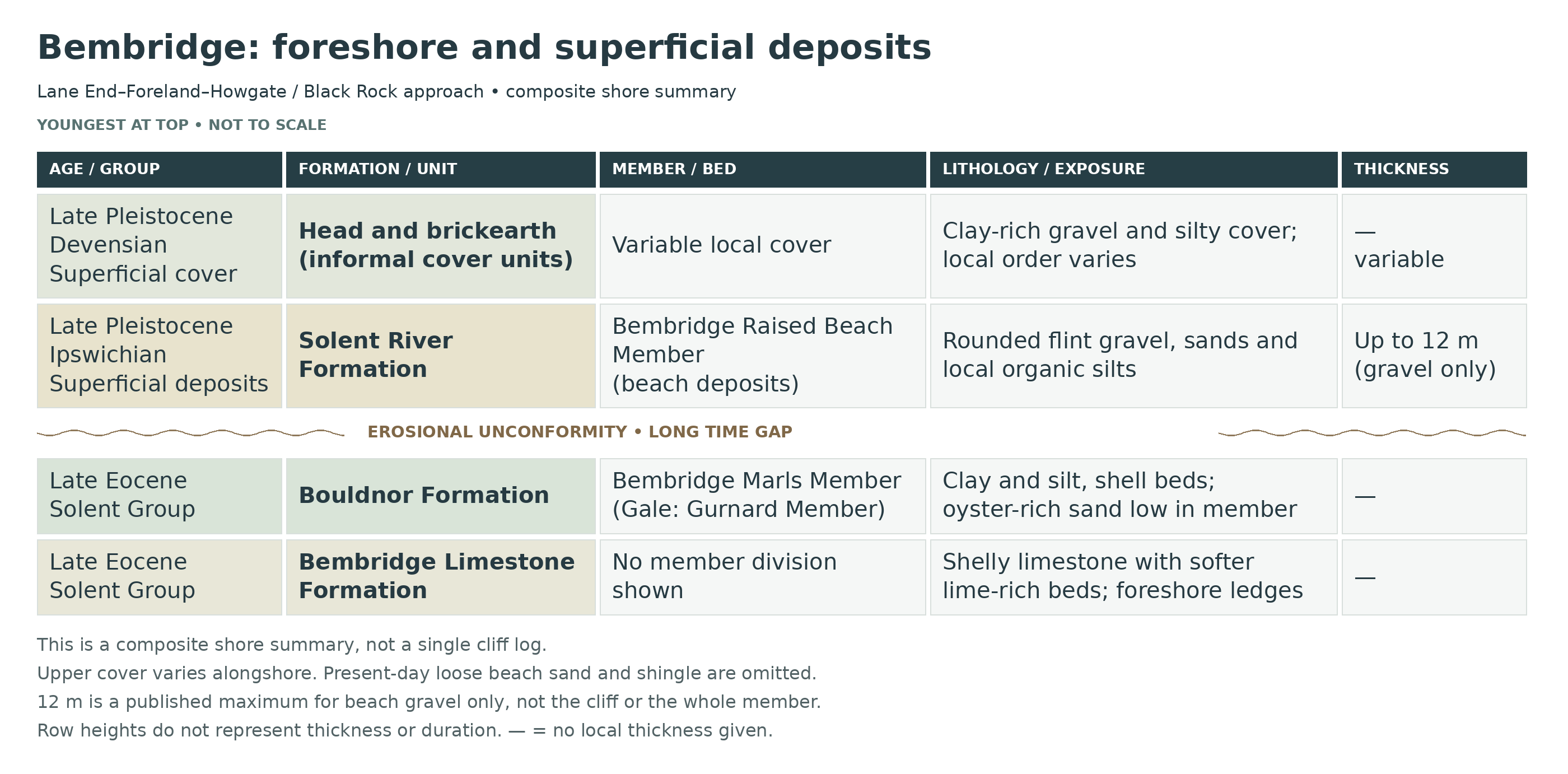
Bembridge’s foreshore exposes the Bembridge Limestone Formation and the overlying Bembridge Marls Member of the Bouldnor Formation, both within the Solent Group. The hard limestone forms the extensive ledges around the shore; softer clay-rich beds appear between rock platforms and in the low cliffs where beach cover permits. These beds are treated here as late Eocene. Their position on the beach should not be confused with their order in the geological succession.
The limestone developed in shallow lakes and their margins. It contains shell-bearing limestone beds separated by softer, lime-rich sediment. The succeeding Bembridge Marls record freshwater and brackish conditions, with the Bembridge Oyster Bed marking a marine influence near their base. On the south-western continuation towards Black Rock, the limestone–marl transition is particularly useful for understanding the relationship between these units.
The Insect Limestone is another horizon within the lower Bembridge Marls. Mollusc-bearing beds above it are documented at Howgate Bay. The famous, exceptionally preserved insect collections associated with this horizon principally come from the island’s north-western coast, so the name should not imply that comparable insect material is routinely found on the Bembridge shore.
A major erosional break separates the Palaeogene bedrock from the much younger Pleistocene superficial deposits. The raised-beach gravel belongs to the Ipswichian interglacial. Younger head, formed by downslope movement in cold conditions, and brickearth also occur. These deposits change considerably along the coast and are distinct from both the fossil-bearing bedrock and the loose sand and shingle of the present beach.

Detailed geology of the Bembridge shore: the late Eocene limestone and marls exposed around Lane End and Foreland, their continuation towards Howgate Bay and Black Rock, and the much younger raised-beach and cold-climate deposits above them.
Locality and exposure
The following is a composite account of the Bembridge foreshore and adjoining low cliffs. Hard limestone ledges and softer clay-rich outcrops are exposed unevenly along this stretch; tide, beach sediment and sea defences affect what can be seen. It is not a single, continuously exposed vertical section. The older bedrock succession is described first, followed by the superficial cover.
SOLENT GROUP
Bembridge Limestone Formation (Late Eocene)
This is the limestone that forms the conspicuous intertidal ledges. The formation comprises limestone and clay-rich limestone, with softer lime mud and clay between harder beds. It records shallow lakes and their margins, with fluctuating water levels and occasional exposure of the sediment surface. Shelly material may be preserved as moulds within the limestone.
The formation lies below the Bembridge Marls Member. Published complete limestone measurements at the northern end of Whitecliff Bay are useful regional reference sections, but are not presented here as the thickness visible at every Bembridge ledge.
Bouldnor Formation
Bembridge Marls Member (Gale 2026: Gurnard Member; Late Eocene)
The Bembridge Marls are the lowest member of the Bouldnor Formation. They consist mainly of clay and silt, with shell-rich intervals and subordinate sand and limestone. Their molluscs record changing freshwater and brackish environments. The lowest beds above the main limestone succession belong to this member; the oyster-bearing horizon is within its lower part, rather than a separate formation.
Upper Bembridge Limestone And Basal Marls At Black Rock
The BGS photograph of the small coastal section between Black Rock and the Bembridge Foreland identifies the top of the Bembridge Limestone, the basal marls and a prominent limestone rib above the Oyster Bed. This is direct evidence for the local order. The harder rib above the oyster-bearing interval must not be confused with the older main Bembridge Limestone ledges beneath it.
Bembridge Oyster Bed
The oyster-rich sand represents a brackish-marine episode. At the transition towards Black Rock, published BGS photographs show the upper Bembridge Limestone, basal Bembridge Marls and a harder limestone rib above the Oyster Bed. Beach sediment can cover the softer horizons, so their visibility varies. No uniform local thickness is assigned to the Oyster Bed in this guide.
Limestone Rib Above The Oyster Bed
A resistant limestone rib is documented above the Oyster Bed in the BGS coastal photograph. The photograph establishes its relative position, but does not supply a bed number or measured thickness. Neither is invented here.
Green Clay Below The Insect Limestone — Howgate Bay
Symonds (2015) records the gastropod Clithon (Pictoneritina) mortoni from green clay below the Insect Limestone at Howgate Bay. This is a specific lower-marl horizon on the Bembridge coast. Its separate type locality at Burnt Wood does not turn the Burnt Wood “Corbicula Bed” into a named bed at Bembridge.
Insect Limestone
The Insect Limestone lies above the Oyster Bed within the lower Bembridge Marls. A published Howgate Bay mollusc locality occurs in beds above this limestone. Its correlation with the celebrated insect-bearing horizon elsewhere on the island does not establish an equivalent insect assemblage at Bembridge. Historic collections labelled Gurnard or Gurnet were assembled along the north-west coast, and much of their material probably came from Thorness Bay.
Shelly Beds Above The Insect Limestone — Howgate Bay
The type stratum of Clithon (Pictoneritina) hillae is in the lower Bembridge Marls above the Insect Limestone at Howgate Bay. Symonds also describes material from the “Polymesoda beds” there. These are fossil-bearing beds within the member, not a separate formation. Their local record is distinguished from specimens of the same species at other Isle of Wight sites.
Limits Of The Bedrock Log
Gale (2026) now provides a detailed measured Gurnard Member log for the Howgate–Whitecliff section south of Bembridge. It supplements the individual Lane End–Foreland–Howgate observations above, but is not a complete log for every part of the wider shore. The following entries retain its exact geographic scope. Neither northwestern member totals nor a full Whitecliff older-rock succession is transferred to the rest of Bembridge.
Howgate measured section: basal decalcified marls
Gale (2026) describes the cliff succession between Howgate Bay and Whitecliff Bay, south of Bembridge. At the base of his local Gurnard Member section, 1 m of largely decalcified marl contains carbonate concretions. This measured interval is scoped to that section, not every limestone ledge around Lane End or Foreland.
Howgate Bembridge Oyster Bed
The fossiliferous Oyster Bed above the basal marls is 0.5–0.7 m thick in Gale’s Howgate–Whitecliff section. This adds a measured local value while preserving the warning above that no uniform Oyster Bed thickness applies across the entire Bembridge shore.
Howgate Insect Limestone Unit
Gale records 1 m of dark clay with syneresis cracks containing a laterally continuous limestone bed 0.2–0.3 m thick. The clay-rich unit and the thinner limestone within it have different thicknesses and are not interchangeable measurements. This lithological correlation does not import the famous northwestern insect assemblage into Bembridge.
T/P marker and lower shelly clays
The overlying clay succession is mollusc-rich and includes the T/P marker in Figure 12. The source’s abbreviated name is retained without a speculative expansion. The Howgate mollusc horizons recorded by Symonds above remain separately identified; they are not assigned to T/P without direct evidence.
Serpulid marker
A distinct serpulid-bearing marker follows T/P in the Howgate log. It is one of the lower-member faunal markers used by Gale to correlate this eastern section with northwestern exposures.
Pc marker
Figure 12 separately identifies the Pc marker above the serpulid horizon. The abbreviation is retained as published; no individual thickness or unverified species name is assigned.
Silt beds, fine-sand lenses and mottled palaeosols
The succession above the lower shell markers is markedly siltier than its northwestern equivalents. Conspicuous silt beds with silt and fine-sand lenses alternate with decalcified red- and yellow-mottled palaeosols. Gale reports silt beds reaching about 1 m in the eastern succession; this is a facies observation, not the thickness of every silt layer.
Potamomya marker
Moulds of bivalves identify the Potamomya marker in the eastern section. Decalcification has removed original shell material from parts of this succession, so the mouldic preservation is itself an important feature.
Gutter-cast horizon
Figure 12 individually marks gutter casts within the silty Howgate succession below the Polymesoda obovata marker. These erosional sedimentary structures retain evidence of local current activity; no unique fossil assemblage or unsupported exact level is assigned.
Polymesoda obovata marker
Gale places this shell marker at 17 m in the Howgate section. It overlies a burrowed surface, correlated with the Thalassinoides-bearing omission surface beneath this marker elsewhere. It is the upper limit to which the paper establishes detailed bed-by-bed correlation between the eastern and northwestern Gurnard Member logs.
Soil-modified silts and clays above Polymesoda
Above the Polymesoda obovata marker, Gale describes pedogenically modified silts and clays without recorded fossils up to 26.2 m. No detailed northwest-coast bed crosswalk is established for this upper interval.
Viviparus-bearing lenses
Above 26.2 m in the Howgate log, lenses contain the freshwater gastropod Viviparus. This named fossil occurrence is retained separately from the underlying unfossiliferous interval; it does not establish a Hamstead Member assignment.
Three caliche and carbonate-concretion levels towards Whitecliff
Figure 13 shows three levels of strong carbonate cementation within the succession below the Polymesoda obovata marker as it is traced from Howgate towards Whitecliff. The paper describes hard caliche development in some palaeosols. These are lateral changes in the measured transect, not three additional limestone formations repeated across Bembridge.
The numerical text and some plotted positions of the lower markers are not fully consistent in the corrected proof. Their observed order is retained, while exact levels are quoted only where the section text provides a clear local value. The T/P, serpulid and Pc markers are not all forced into the same 3.5–4.8 m interval.
Age and terminology
Late Eocene is used here for the limestone and lower Bembridge Marls, following the modern literature and the BGS member entry. Older accounts used Oligocene, and some database age fields retain broader ranges. The Eocene–Oligocene boundary is not marked as an observed horizon on this shore. Gale (2026), following King (2016), uses Gurnard Member for the interval termed Bembridge Marls Member in BGS (2015). The names are shown together here, not treated as additional layers.
QUATERNARY SUPERFICIAL DEPOSITS
Solent River Formation — Superficial Deposits
Bembridge Raised Beach Member — Ipswichian
This younger classification is separate from the Palaeogene Solent Group. The deposits rest on an erosional surface cut into the bedrock.
Lower Beach Gravel
Rounded, iron-stained flint gravel with sand lenses reaches 12 metres in published local sections: gravel thickness only.
Sand And Silty-Clay Beds
Orange-white sand and blue-grey silty clay overlie gravel locally, reaching 1.5 metres at mapped Site A.
Organic Silty Clay — Lateral Variation
North-eastwards, the fines become organic silty clay: a lateral change, not another universal layer.
Separate Lane End Record
Reid and Strahan interpreted valley-fill cutting the beach gravel; the later review leaves that relationship unresolved. Preece’s local log ascends:
Basal Silty Gravel — 20 cm
Dark silty gravel, becoming sandier downwards.
Sedge Peat — 27 cm
Humified peat with an eroded upper contact.
Silty Sand — 40 cm
Olive below, brownish-yellow above.
Angular Gravel — 150 cm
Flint gravel beneath soil, interpreted as local river sediment.
Younger Head And Brickearth — Devensian Cover
Clay-Rich Solifluction Gravel
Clay-rich, matrix-supported gravel reaches 2.5 metres at mapped sites U, W and Y–Z, and 3.5 metres near the former Chalet Hotel slipway. Locally it rests directly on bedrock.
Brickearth And Local Upper Gravel
Silty cover generally stays below 1.5 metres, but reaches 10.5 metres in a Howgate depression; another gravel overlies it.
Reading the stratigraphic chart
The chart shows the broad order of deposition, with the youngest deposits at the top. Its row heights do not represent thickness or time. A dash means that no thickness is assigned to the composite exposure shown. Modern beach sand, shingle and displaced blocks can hide or mix material from several units and are not included as bedrock formations.
References
British Geological Survey, Geology of the Isle of Wight: Bembridge Limestone, Bembridge Marls and superficial deposits (2015).
BGS Lexicon: Bembridge Limestone Formation.
BGS Lexicon: Bembridge Marls Member.
BGS Lexicon: Bembridge Raised Beach Member.
Armenteros, Daley and García (1997), Lacustrine and palustrine facies in the Bembridge Limestone.
Symonds (2015), New species of Neritidae from the Solent Group: Howgate Bay locality and horizon.
Gale (2020), Eocene balanomorph barnacles: Bembridge Oyster Bed age and environment.
Selden (2014), Spiders from the Insect Limestone: locality and stratigraphical context.
Briant, Haggart, Schreve and Whiteman (2022, accepted manuscript), Quaternary sea-level landforms and sediments in southern England, section 4.3.
SCOPAC, North East Isle of Wight: Bembridge Point to Forelands Field coastal geology.
Gale, A. (2026), Stratigraphy of the Bouldnor Formation, section 5, Figures 12–14: exact Howgate–Whitecliff measured section and limits of northwestern correlation.
SAFETY
The foreshore at Bembridge can be very slippery, particularly during wet conditions or when algae is present on the rocks, so extra care should be taken when walking.
At the south-western end of the site, the sea can reach the base of the cliffs, making this area prone to being cut off by the tide. It is essential to check tide times in advance and ensure you begin your return before the tide turns.
Cliff falls are also a risk along this stretch, so avoid standing close to the cliff base and remain aware of your surroundings at all times.
EQUIPMENT
Use a small geological hammer and chisel only on permitted loose shell-bearing blocks on firm, open foreshore, well clear of cliff bases and unstable ground. Wear eye protection, keep other people clear and stop splitting as soon as a fossil appears. Do not hammer the bedrock.
A small trowel can help separate permitted loose pieces of clay or marl already washed onto safe foreshore. Do not dig into cliffs, banks or attached beds; keep fragile fossils supported in their matrix.
It is also recommended to bring specimen bags, containers and wrapping materials, as many fossils—particularly shells—can be fragile and easily damaged during transport.
CLEANING AND TREATING
Support fragile shells, bones and teeth in their matrix, and remove only loose surface sediment with a very soft brush. Do not routinely soak every find for 24 hours: water may soften clay-rich matrix or harm unstable material, and salt removal needs a specimen-specific plan. Avoid heat and rapid drying; seek preparation advice before treating an important or crumbling specimen.
Paraloid B-72 can help selected fragile areas after testing, but sound fossils do not automatically need coating. It is not a waterproof seal, and complete removal from porous fossil or matrix cannot be guaranteed. Keep specimens supported in stable storage and document any treatment. Delicate impressions and scientifically important finds should be assessed before applying adhesive or consolidant.
IDENTIFY YOUR FINDS
Need help identifying a fossil? Share clear photos, where you found it and its size with the community.
FURTHER READING
Deposits Magazine – Book review: Isle of Wight: Landscape and Geology, by John Downes
Geology of the Isle of Wight — British Geological Survey
Whitecliff Bay and Bembridge Ledges SSSI: citation
Whitecliff Bay — GCR fossil mammals
ACCESS RIGHTS
This site is a site of special scientific interest (SSSI). This means you can visit the site, but hammering the bedrock is not permitted. For full information about the reasons for the status of the site and restrictions, download the PDF from Natural England.
It is important to follow our ‘Code of Conduct’ when collecting fossils or visiting any site. Please also read our ‘Terms and Conditions‘
LINKS
♦ Fossil Discussions
♦ Fossil Articles
♦ Buy Fossils, Tools and Equipment
♦ Buy Crystals, Meteorites, and Artefacts
♦ Join Fossil Hunts
♦ UK Fossils Network