Brook Bay is one of the Isle of Wight’s most famous dinosaur localities, where teeth, bone fragments, fossil wood and reptile remains are regularly found with careful searching. Most material is worn, but storms and beach scour can reveal fresh specimens. The bay is also renowned for its dinosaur footprints, preserved both in situ and as natural casts on the foreshore, making it a key site for dinosaur discoveries.


FIND FREQUENCY: ♦♦♦♦ – Although lots of fossils can be found, you will often need the right conditions.
CHILDREN: ♦♦♦ – Brook Bay is suitable for families with good access
ACCESS: ♦♦♦♦♦ – Brook Bay has easy parking, with quick access down to the beach. This is free to National Trust Members, or chargeable to non members.
TYPE: Most fossils are found loose on the foreshore. Leave any fossils still embedded in the cliffs in place; photograph and report potentially important finds.
DIRECTIONS
♦ Brook Bay is best accessed from the Brook Chine National Trust Car Park.
♦ From Brook Chine, Hanover Point and its dinosaur footprint beds lie to the north-west; the beach towards Sudmoor Point extends south-east. Check the tide and sea conditions before walking along either stretch.
♦ Postcode to parking: PO30 4HA; Google Maps Link
♦ What3Words to the Dinosaur Footprints: ///loaning.twist.portable
VIDEO FILM
FOSSIL HUNTING
Brook Bay is best searched on a low tide, especially after rough weather or when scouring has stripped back the beach and exposed fresh material. Most fossils are found loose on the foreshore rather than extracted from the cliff. The shingle is often the most productive place to look, as wave action concentrates heavy and resistant pieces of bone, teeth, lignite, and ironstone-rich fossils among the pebbles. Searching slowly and methodically gives the best results, particularly in wave-sorted shingle and on the lower foreshore where the tide allows a safe return. Keep well clear of cliff bases and active falls, and do not climb landslips.
Dinosaur remains are the main attraction. Most are found as rolled and worn fragments, but even these are unmistakable once you learn the look of fossil bone: dark, dense, often with a porous internal structure. Teeth are scarcer, but they do turn up, especially after strong tides and major scour. Whole bones are uncommon but possible. Brook Bay has long produced dinosaur material from the Wessex Formation, and the wider Brook–Atherfield coast is one of the most important Lower Cretaceous dinosaur stretches in Europe.
The footprint beds are another major reason the site is so important. Ripple-marked bedding planes and footprint-bearing surfaces can sometimes be seen on the foreshore, particularly towards Hanover Point. Brook Bay and the adjoining coast are well known for iguanodontid and theropod footprints and trackways, and additional four-toed footcasts have also been recorded, probably made by sauropods or armoured dinosaurs. A complete trackway from this part of the coast is held by Dinosaur Isle. These prints are not always obvious at first glance, so it is worth taking time to study flat rock surfaces at low tide.
Brook Bay can also produce other vertebrate fossils from the same beds. Along this coast, collectors have found fish remains, turtle material, crocodile remains, and pterosaur bones, alongside the dinosaurs. A recently described side-necked turtle fossil was found on the foreshore at Brook Bay, showing that important discoveries are still being made here.
Most dinosaur finds are isolated and water-worn. Brook Bay has a long record of iguanodontian bones, vertebrae and teeth, and the sacrum named Ornithodesmus cluniculus came from a Brook Bay find. The much wider south-west Isle of Wight Wessex succession contains a richer named dinosaur fauna, but its species list should not be treated as a checklist for this one bay. In practical collecting, an indeterminate bone fragment or isolated tooth is much more likely than material identifiable to species. Keep the locality and attached matrix with the specimen: those details can matter more scientifically than a tentative name.
Dinosaur footprints and trace fossils
Brook Bay and Hanover Point are famous for dinosaur footprints preserved in the Wessex Formation. These include large ornithopod footprints traditionally referred to iguanodontids, theropod prints, and four-toed forms attributed to sauropods or thyreophorans. Ripple marks, track-bearing bedding planes, and natural casts are all part of the attraction here, and they are just as important as body fossils.
Other reptiles
Brook Bay does not only produce dinosaurs. Reptile remains from the Wessex Formation coast include turtles and crocodiliforms, and the area has also yielded pterosaur material. These are generally found as isolated, worn fragments on the beach rather than as obvious complete specimens.
Fish
Fish fossils are also part of the Brook Bay fauna. The Brook–Atherfield section has produced remains such as Lepidotesand hybodont shark teeth, along with other fish scales and bone fragments. These are easy to overlook, so small dark glossy pieces in the shingle are always worth checking.
Pieces of lignite, fossil wood and plant debris are common companions of Brook Bay’s vertebrate fossils. Dark wood may show a fibrous grain, whereas bone can show a porous internal structure and a denser outer surface; colour alone is unreliable. At Hanover Point the Pine Raft is a much larger in-situ accumulation of carbonate-mineralised logs within sandstone. Photograph these logs and leave them undisturbed. The small loose plant fragments on the beach and the large embedded logs illustrate different modes of preservation, and neither should be confused automatically with dinosaur bone.


Some of the most significant fossil discoveries from Brook Bay and the adjoining Hanover Point coast include early dinosaur material used in the history of Dinosauria, some of the first published dinosaur footprints from the Isle of Wight, important named Victorian finds, and a remarkable modern turtle discovery.
1842 – Iguanodon sacrum used by Richard Owen in defining Dinosauria
One of the most historically important discoveries from the Brook Bay area was an Iguanodon sacrum used by Richard Owen in 1842 when defining Dinosauria. This makes Brook Bay part of the early scientific history of dinosaurs, not just an important collecting locality.
1851–1862 – Samuel Beckles and the first published footprint discoveries
Samuel Husbands Beckles was the first to publish on dinosaur footprints from this stretch of coast. He referred to footprint casts in 1851, and by 1862 had described and figured dinosaur foot casts from the Brook Bay and Hanover Point area, helping establish it as one of the classic footprint localities on the Isle of Wight.
1872 – Iguanodon specimen collected between Hanover Point and Brook Chine
A specimen referred to Iguanodon was collected in 1872 from the Hanover Point to Brook Chine stretch. This is one of the specifically dated historic dinosaur records from the wider Brook Bay coast and shows how long the area has been known for important dinosaur material.
1887 – Ornithodesmus cluniculus described from a Brook Bay find by Rev. William Fox
A sacrum found at Brook Bay by Rev. William Fox was described by Harry Govier Seeley in 1887 as Ornithodesmus cluniculus. It later became one of the classic named Brook Bay dinosaur finds and is well known for its complex history of reinterpretation.
2015 – side-necked turtle found by Steve Burbridge
A turtle fossil found on the Brook Bay foreshore by Steve Burbridge in 2015 was later identified as the first side-necked turtle discovered in the UK. It showed that Brook Bay is not only historically important, but is still producing scientifically significant fossils today.
GEOLOGY
The geology at Brook Bay is part of the Wessex Formation of the Wealden Group, deposited during the Early Cretaceous, specifically the Barremian Stage. These rocks represent a lowland river and floodplain environment, where channels migrated across muddy overbank ground and periodically laid down sands, silts, clays, plant debris and soil horizons. This is why the sequence contains such a mixture of fossils, from dinosaur bones and footprints to wood and fish remains.
At Brook Bay, river-channel sandstones and their associated floodplain mudstones crop out around the hinge of the Brighstone Anticline. The Hanover Point and Sudmoor Point sandstones are geographical parts of this composite section, not two layers that can simply be measured one above the other across the bay. Pale channel sands, reddish or purple overbank mudstones and darker plant-debris lenses change laterally, and slipped ground or beach sand may conceal the contacts. These relationships explain why a fossil found loose on the beach cannot always be traced back to an exact bed, even when its broad Wessex origin is clear.
The footprint beds are part of this story. Dinosaur tracks formed on wet sediment surfaces which were later buried and preserved, in some cases as undertracks or natural casts. At Brook Bay and Hanover Point, erosion of the foreshore has revealed these surfaces again, allowing visitors to see not just the bones of dinosaurs, but direct evidence of their movement across the Cretaceous landscape. That makes Brook Bay valuable both palaeontologically and sedimentologically: it preserves the animals themselves and the environments they walked across.
The Wessex Formation is world famous because it preserves one of the richest non-marine dinosaur faunas in Europe. Brook Bay is one of the best-known places to see this formation in action on the coast, with erosion constantly releasing new material from the cliffs and foreshore. For fossil hunters, that means the site is dynamic: beach conditions can change quickly, productive areas move around, and a storm can reveal fossils and footprints that were hidden only days before.

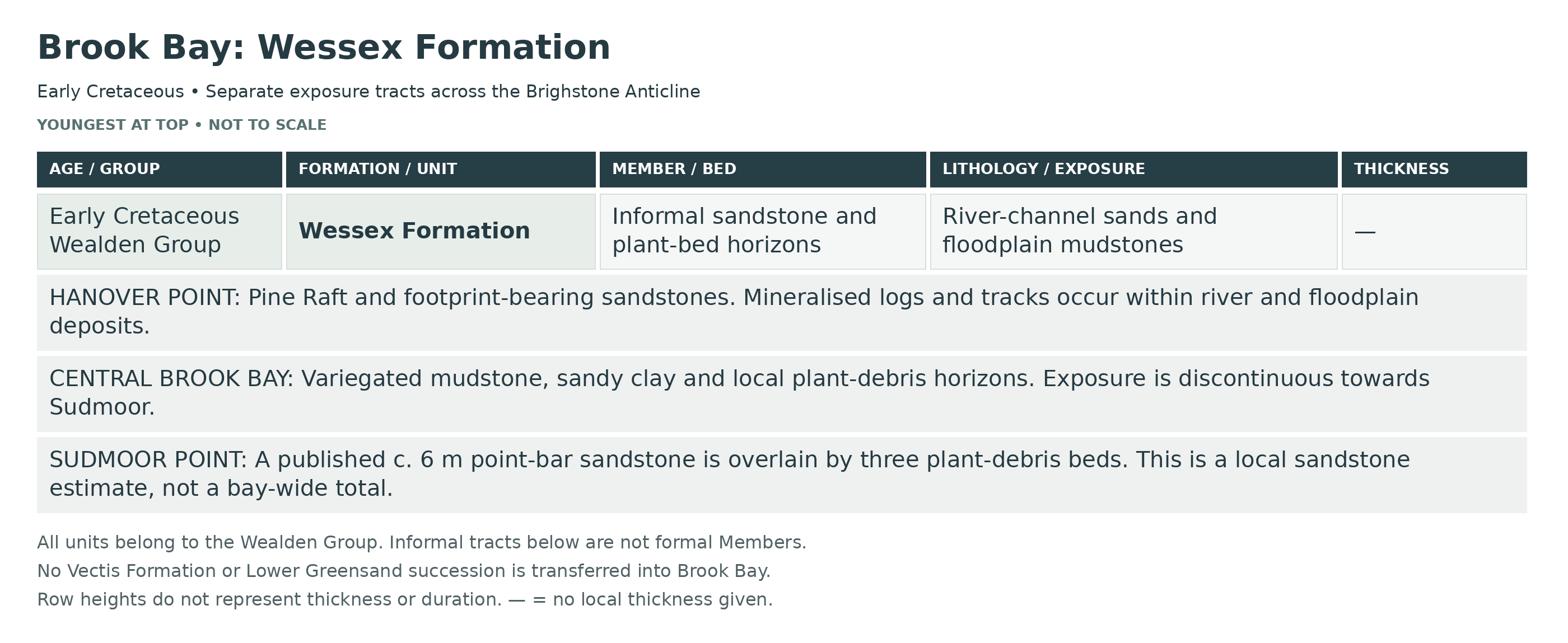
This is a detailed composite breakdown of the Brook Bay lower Wessex Formation section between Hanover Point and Sudmoor Point, where Barremian river-channel sandstones, plant-debris beds and red floodplain mudstones are exposed around the Brighstone Anticline hinge. The locality is important for the Hanover Point Pine Raft and footprint-bearing sandstones, for the historically productive dinosaur and plant beds of central Brook Bay, and for the Sudmoor Point Sandstone with its vertebrate-rich plant-debris horizons.
The Sudmoor descriptions refer to the headland at the south-eastern end of Brook Bay; published records extending onwards towards Chilton Chine are identified as that adjacent continuation, not automatically assigned to every part of Brook Bay. The three exposure tracts below are geographical panels. Their listing is not proof of a continuously measurable vertical succession.
WEALDEN GROUP
Wessex Formation (Barremian, Lower Cretaceous)
Brook Bay is not a single simple vertical cliff log. The bay lies close to the hinge area of the Brighstone Anticline, the foreshore curves round Hanover Point and Sudmoor Point, central parts are commonly affected by collapse and sand cover, and the Isle of Wight Wessex Formation has no formal internal subdivision. The BB beds below are therefore practical site-use units tied where possible to published named sandstones and plant-debris beds, and they are arranged as a composite Brook Bay section from Hanover Point through the central bay to Sudmoor Point rather than as a falsely continuous straight cliff log.
Hanover Point Interval (informal site-use subdivision)
Bed BB1 — Hanover Point Sandstone And The Pine Raft
At Hanover Point itself, low tide exposes the famous Pine Raft, a concentration of large calcite-mineralized conifer logs incorporated within the Hanover Point Sandstone of Stewart’s section. The logs have been compared with Pseudofrenelopsis parceramosa, but the GCR figure caption places the Pine Raft wood in the form-genus Dadoxylon because of its more araucarioid tracheid arrangement. They may reach about 40 cm in diameter and several metres in length, and rest within fluvial sandstone rather than in a true grey plant-debris bed. This is one of the most distinctive horizons in the whole Isle of Wight Wessex Formation and is best interpreted as a stranded log accumulation or log jam on a river-channel or point-bar surface. It lies low in the exposed Wessex succession and close to the level at which later work placed the Hauterivian–Barremian transition on the south-west coast.
Bed BB2 — Hanover Point Footprint Sandstone Complex
Higher sandstone units at and immediately around Hanover Point form the classic dinosaur footprint-bearing beds. A hard reddish-grey sandstone exposed on the foreshore and in the cliff preserves casts on its underside from a dinoturbated mud surface below, and equivalent sandstone continues into Brook Bay where fallen blocks commonly show tracks in section. The track assemblage is dominated by large ornithopod footprints, many more than 50 cm long, with rarer theropod and occasional thyreophoran prints; a short ornithopod trackway has been documented, although its visibility depends on beach conditions and a possible sauropod pes impression has also been noted. Sedimentologically these are crevasse-splay or sheet-sand deposits laid abruptly across muddy floodplain surfaces and then preserved as hyporelief casts when the underlying mud was trampled by dinosaurs.
Central Brook Bay Interval (informal site-use subdivision)
Bed BB3 — Brook Bay Overbank Mudstones, Sandy Clay And Local Plant-Debris Beds
Between Hanover Point and Brook Chine the cliffs and foreshore are dominated by red, purple and variegated overbank mudstones with subordinate thin sandstones, local sandy clay and thin grey plant-debris beds. Historically this stretch yielded many dinosaur bones from sandy clay with unionid bivalves above the Pine Raft, from hard nodule beds west of Brook Chine, and from plant-rich grey horizons on the shore. Buckland’s Bull-face Ledge with ironstone loaded with prostrate fossil tree trunks belongs to this same general interval. At least one Brook Bay plant-debris bed has also yielded abundant remains of Lepidotes, including scales and fin material, together with rare turtle remains. These beds represent a mosaic of floodplain mud accumulation, abandoned-channel or pond fills, and locally generated debris-flow deposits rich in washed-in plant and vertebrate remains.
Sandy clay with unionids above the Pine Raft: historical record
Mantell’s account, summarised in GCR10 locality 5, places dinosaur-bearing sandy clay with Unio above the Pine Raft. This is a historically recorded horizon, not a guaranteed current exposure.
Hard-nodule bed west of Brook Chine: historical record
Hulke separately described a hard-nodule bed between coloured clays and the younger gravel cap west of Brook Chine. Dinosaur material came from beside a small gully. Its precise correlation remains uncertain.
Bed BB4 — Brook Chine To Sudmoor Point Poorly Exposed Mudstone–Sandstone Interval
Much of the central to south-eastern part of Brook Bay is too collapsed and changeable for a trustworthy permanent bed-by-bed cliff log. Where visible, the succession is still mainly red and purple overbank mudstone with subordinate white to pale grey sands, local sideritic or nodular bands and occasional plant-debris lenses. This obscured tract is important because it links the Hanover Point footprint and plant horizons with the more clearly exposed Sudmoor Point Sandstone, but it must be treated honestly as an intermittently exposed floodplain succession rather than as a clean continuously measurable section.
Sudmoor Point Interval (informal site-use subdivision)
Bed BB5 — Sudmoor Point Sandstone (c. 6 m)
The Sudmoor Point Sandstone is the dominant marker horizon at the south-eastern end of Brook Bay and forms a major light-coloured cliff and foreshore sandstone body. In the classic descriptions it is a massive sandstone with irregular bone-bearing bands and a basal gravel lag 0.2–0.6 m thick containing bones; tridactyl dinosaur footprints occur near its top. More recent work interprets it as a substantial fluvial point-bar sandstone within the lower exposed Wessex Formation. Channel-lag material and associated beds have yielded abundant teeth of the semionotiform fish Lepidotes. This unit is therefore both the main architectural river-channel body of Brook Bay and the key field horizon for locating the Sudmoor vertebrate beds above.
Red and purple marls beneath Sudmoor sandstone
The older section records at least 6 m of red and purple marls beneath the sandstone. This is exposed thickness, not a complete lower-Wessex total.
Sudmoor basal gravel lag (0.2–0.6 m)
The gravel at the sandstone base contains bones. Its variable thickness belongs to the basal lag, not the main sand body.
Main Sudmoor Point Sandstone body
The approximately 6 m sandstone represents a fluvial point bar. Irregular bone-bearing bands are recorded in the older description.
Sudmoor sandstone upper track surface
Tridactyl footprints occur near its top. Detailed multi-track records farther towards Chilton belong to that adjacent tract, not every Brook exposure.
Bed BB6 — Plant Debris Bed L1 Above The Sudmoor Point Sandstone (variable, locally to c. 1 m)
Immediately above the irregular upper surface of the Sudmoor Point Sandstone lies the most important Sudmoor Point plant-debris bed, Stewart’s L1. It is laterally continuous but highly variable, ranging from little more than a thin grey siltstone to a bed approaching 1 m thick with abundant plant debris, logs, pyritic wood and bone, and sideritic concretions. A basal pea-gravel and pebble lag may fill shallow hollows in the sandstone top. This bed is rich in vertebrate remains, including dinosaur and crocodile material, and it is the probable source of the pterosaur rostrum IWCMS 2014.82, described by Martill (2015) as Coloborhynchus from Sudmoor Point, although the two higher plant-debris beds are also possible sources of that loose specimen; the precise bed provenance of the giant sauropod cervical vertebra mentioned in the earlier guide has not been established by the checked sources, so it is not assigned to L1 here. Sedimentologically it is a classic Wessex plant-debris bed, best interpreted as a locally generated sheetflood deposit transformed into a debris flow and ponded on the floodplain above the channel sandstone.
L1 basal pea-gravel and hollow fills
The plant-debris unit follows the irregular sandstone top. Pea-gravel locally fills shallow hollows or small channels rather than forming a uniform layer. The 2019 pterosaur account describes this local basal lag separately from the overlying organic-rich body.
L1 plant-rich body
Above the irregular base, grey sediment carries wood, vertebrate debris and sideritic concretions. Martill (2015) records pyritic wood and bone with dinosaur and crocodilian remains. The sandstone topography and variable debris supply explain why the plant-rich bed changes thickness laterally.
Bed BB7 — Higher Sudmoor Cliff Plant Beds And Variegated Overbank Mudstones
Two further plant-debris beds occur higher in the Sudmoor Point cliff above L1, interbedded with red and variegated overbank mudstones and siltstones. One of these higher beds is notable for yielding large articulated unionid bivalves, showing quiet ponded freshwater conditions after the main debris-flow event. Plant-rich laminated mudstone also occurs high in the cliff, representing the rarer evenly plant-charged style of Wessex plant bed rather than the more usual basal-conglomeratic type. Together these beds record repeated occupation of topographic lows on the alluvial plain by shallow standing water, abandoned channels and ephemeral lakes. The Sudmoor Point area has yielded additional important lower-Wessex vertebrate remains from these beds and adjacent mudstones, including the small ornithopod Vectidromeus insularis from this low part of the exposed succession.
Higher Sudmoor plant bed with articulated unionids
Martill (2015) distinguishes a higher plant-debris horizon yielding large articulated unionid bivalves. It is kept separate from L1; no unsupported L-number is assigned.
Other higher Sudmoor plant-debris bed
A further plant-debris bed is recorded above L1. The available description does not justify assigning a separate L-number or a unique fossil fauna to it. Both higher beds remain possible sources for loose fossil material found below the cliff.
Beds Not Included In Brook Bay Proper
Although the higher Isle of Wight succession is famous for the Hypsilophodon Bed, the White Rock, the Vectis Formation and the overlying Atherfield Clay, those beds do not belong to Brook Bay proper. They crop out higher and farther along the Brighstone Bay coastal section beyond the Brook Bay lower-Wessex interval. Brook Bay itself is therefore a lower Wessex locality, not a White Rock–Vectis–Lower Greensand section.
Typical Fossils
Brook Bay is productive mainly in rolled beach material and in fallen blocks from thin grey plant-debris beds and sandstones. Characteristic finds and documented in situ fossils include large ornithopod footprint casts together with rarer theropod and thyreophoran tracks; calcite-mineralized conifer logs at the Pine Raft, with the anatomical identification caveat noted above; fish remains including Lepidotes; unionid bivalves; crocodilian teeth and bones; dinosaur bones ranging from isolated elements to partial skeletons; and rarer pterosaur material from the Sudmoor Point plant-debris beds. Fossil wood, charcoalified plant fragments and calcareous or sideritic concretions are common accompaniments.
Depositional Environment
The Brook Bay succession records deposition on a low-relief, seasonally dry to seasonally wet alluvial plain within the Wessex Basin. The dominant red and purple mudstones are overbank floodplain deposits with pedogenic overprint; the Hanover Point and Sudmoor Point sandstones represent river-channel or point-bar bodies, with some thinner sands recording crevasse splays; the footprint beds formed where sand spread across soft muddy surfaces trampled by dinosaurs; and the thin grey plant-debris beds represent locally generated sheetflood and debris-flow deposits that accumulated in ponds, abandoned channels and other low areas on the floodplain, concentrating wood, plants, fish, crocodiles and dinosaurs. Brook Bay is therefore one of the best places on the Isle of Wight to see the interplay of channel, overbank, pond and vertebrate-concentrating facies within the lower Wessex Formation.
Total Thickness Covered Here
Brook Bay proper exposes only part of the lower Wessex Formation and cannot be given a single precise total thickness because the bay is a curved composite fold-hinge section rather than a straight continuously measurable vertical log. The Sudmoor Point Sandstone alone is about 6 m thick, at least 6 m of deep red and purple marls were noted below it in the classic section, and the Sudmoor Point cliff carries three plant-debris beds above it. Farther round the bay, the Hanover Point Sandstone and central Brook Bay mudstone–plant-bed intervals represent additional tens of metres of lower exposed Wessex. The Sudmoor Point succession lies low in the exposed island Wessex, roughly 150 m below the Hypsilophodon Bed higher in the Brighstone Bay section.
References
Osborne White, H.J. (1921). A Short Account of the Geology of the Isle of Wight.
Stewart, D.J. (1978; 1981a) on the stratigraphy, named coastal marker beds and sedimentology of the Isle of Wight Wessex Formation.
Daley, B. & Stewart, D.J. (1979). Formalization of the Wessex Formation and Vectis Formation terminology for the Isle of Wight Wealden succession.
British Geological Survey Lexicon: Wessex Formation and Vectis Formation; and British Geological Survey, Geology of the Isle of Wight, part sheets 300, 331, 344, 345: brief explanation.
Geological Conservation Review accounts: Brook–Atherfield, Isle of Wight and Hanover Point.
Insole, A.N. & Hutt, S. (1994). Palaeoecology of the dinosaurs of the Wessex Formation.
Sweetman, S.C. & Insole, A.N. (2010). The plant debris beds of the Early Cretaceous Wessex Formation of the Isle of Wight and their significance.
Lockwood, J.A.F., Lockley, M.G. & Pond, S. (2014). Review of dinosaur footprints from Hanover Point.
Martill, D.M. (2015). First occurrence of the pterosaur Coloborhynchus from the Wessex Formation of the Isle of Wight.
Lockwood, J.A.F., Martill, D.M. & Maidment, S.C.R. (2021) and Longrich, N.R. and co-authors (2024) on the lower Wessex dinosaur-bearing beds at Hanover Point and Sudmoor Point.
Checked source links: Hopson and Farrant (2015), Isle of Wight: Wessex Formation and Figure 14; Benton and Spencer (1995), GCR 10: Brook–Atherfield, Brook Bay localities 5–8; Cleal and colleagues (2001), GCR 22: Hanover Point; Martill (2015), First occurrence of Coloborhynchus from the Wessex Formation, Geological setting; Additional evidence for very large wing-span pterosaurs in the Wessex Formation; Longrich and colleagues, Vectidromeus insularis, Cretaceous Research 105707; Lockwood, Lockley and Pond (2014), A review of footprints at Hanover Point; Sweetman and Insole (2010), The plant debris beds of the Early Cretaceous Wessex Formation.
EQUIPMENT
Collecting here is by careful surface searching rather than hammering or digging. A slow, patient search of the shingle and lower foreshore is usually more productive than aggressive collecting. Even so, a few basic items are very useful.
A small collecting bag or sturdy specimen boxes are worth taking so that finds do not get damaged in your pocket. Kitchen roll, tissue, or small wraps help protect teeth and fragile bone fragments. A hand lens is useful for checking surface texture, especially when trying to tell fossil bone from ordinary dark pebbles. Gloves can be handy when searching coarse shingle or handling sharp fragments, and a camera or phone is useful for recording footprints or in situ finds before moving anything.
Follow the National Trust’s guidance for the Brook–Compton coast: do not use hammers or other digging tools, and leave dinosaur foot casts in place. Photograph any potentially important fossil in the cliff and report it rather than attempting to excavate it. Bring a rucksack, drinks, waterproofs and footwear with a good grip, as the beach can be slippery and conditions can change quickly. A finds bag, hand lens and time for careful surface searching are more useful here than heavy tools.
SAFETY
Brook Bay is a rewarding site, but it can also be dangerous. Tide awareness is essential. The beach can cut off quickly, and you should always check tide times before visiting and plan to return well before the tide turns. This part of the coast is well known for difficult tidal conditions, and getting trapped against the cliff or isolated by incoming water is a real risk.
Take great care around the cliffs and any recent falls. The cliffs are unstable, and material can come down without warning. Searching directly beneath them is risky, particularly after wet weather or frost. Slipped ground and mud can also be treacherous, especially where the cliff has moved onto the beach. Some areas become extremely sticky, and it is possible to sink or lose footing on the slippages.
The foreshore itself can be uneven, slippery, and tiring to cross. Algae, wet rock, loose shingle and hidden hollows all add to the risk, so sturdy footwear is important. Never rely on one route back, keep an eye on sea conditions throughout your visit, and do not stay out too long trying to squeeze in a last search. At Brook Bay, common sense, tide awareness, and avoiding the cliff base are the key safety rules.
CLEANING AND TREATING
Start with a soft brush on stable specimens. Do not prescribe a fixed soak for every find: porous bone, lignite and pyritic plant-debris material may be damaged by water or handling. Keep fragile or potentially important finds supported and seek preparation advice before soaking or removing matrix. If a robust, water-safe specimen needs salt removal, choose the treatment for that material and let it dry gently at room temperature, away from heaters.
Do not routinely varnish or seal every fossil. Paraloid B-72 can help consolidate a specimen that is genuinely friable, but the method should suit its condition. Although the resin is soluble, treatment cannot always be completely reversed after it penetrates a fossil. Seek specialist advice for important material and record any treatment.
IDENTIFY YOUR FINDS
Need help identifying a fossil? Share clear photos, where you found it and its size with the community.
FURTHER READING
Deposits Magazine – Finders, keepers: The lost world of some Isle of Wight geological heroes
Deposits Magazine – Histology of a sauropod rib bone from the Wessex Formation, Hanover point, Isle of Wight (adjacent Hanover Point)
National Trust – Fossil hunting and geology at Compton Bay and Downs
GCR / GeoGuide – Brook–Atherfield, Isle of Wight (wider coastal reptile account)
British Geological Survey – Geology of the Isle of Wight (island-wide geological context)
ACCESS RIGHTS
This site is a site of special scientific interest (SSSI). This means you can visit the site, but hammering the bedrock is not permitted. For full information about the reasons for the status of the site and restrictions, download the PDF from Natural England.
It is important to follow our ‘Code of Conduct’ when collecting fossils or visiting any site. Please also read our ‘Terms and Conditions‘
LINKS
♦ Fossil Discussions
♦ Fossil Articles
♦ Buy Fossils, Tools and Equipment
♦ Buy Crystals, Meteorites, and Artefacts
♦ Join Fossil Hunts
♦ UK Fossils Network