
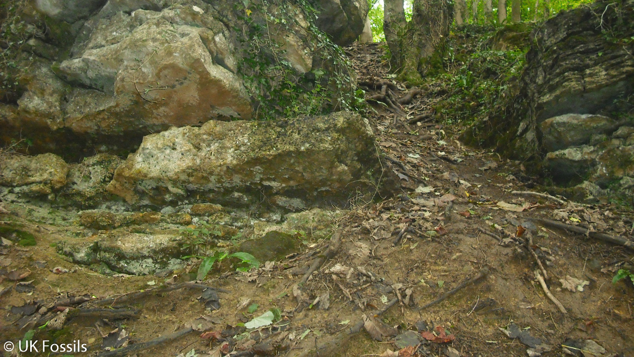
Overview
Directions
- Approach Bathford from the A4 and A363 Bradford Road. Follow Bathford Hill and Prospect Place towards Monkton Farleigh; the road climbs steeply to the reserve car park.
- The Avon Wildlife Trust car park is at grid reference ST 797 663. The original guide’s locality reference, 51.39657°N, 2.29209°W, identifies the reserve area rather than every quarry exposure.
- Use the current Cotswolds National Landscape geology walk and the reserve notices. Its route was checked in October 2025 and the online walk reviewed in April 2026. Older numbered posts are not a reliable substitute for the current directions.
- Stay on open main paths, keep dogs on a lead and follow ash-dieback closures. Do not enter the underground quarries or climb quarry faces to reach a fossil horizon.
Location photographs
Swipe to browse · Select a photograph to enlarge


Fossil Hunting
Begin by looking at naturally exposed rock surfaces and loose pieces beside the open paths. The pale ooidal limestones contain tiny rounded grains, while shell-rich beds show broken valves and thicker fossil sections. The harder coral-bearing rocks weather into irregular, sometimes cavernous surfaces; a hand lens and side-lighting help distinguish the pattern of a coral colony from ordinary holes, weathering pits and burrows. Photograph useful features with a scale rather than levering material from the face.
The Corsham Limestone contains two distinct coral-bearing intervals. The lower Corsham Coral Bed was called the Roof Bed by quarrymen because it formed a strong roof above the Bath Oolite workings. Its top has borings and attached oysters. Higher in the formation, the Bradford Coral Bed contains corals, brachiopods, oysters and other large, thick-shelled bivalves. A small reef-knoll is documented about 45 m north of the tower. These are records of a living and repeatedly colonised seafloor, so the relationship between a fossil and its surrounding rock is often more informative than a detached specimen.
The thin fossiliferous clay immediately above the upper coral bed belongs to the base of the Forest Marble Formation. This is the local horizon traditionally associated with the Bradford Clay fauna. Published records include the pear-shaped crinoid Apiocrinus, the brachiopod Digonella digona, other rhynchonellid brachiopods and oysters. Crinoid stem fragments may resemble small discs or jointed rods, while brachiopods have two valves arranged differently from those of bivalves. Do not dig the clay from the face: removing a soft seam undermines the rocks above and damages the exposure.
The upper Combe Down Oolite has a separate, 0.31 m brachiopod-rich interval within a thicker limestone bed. The recorded identifications are Kallirhynchia cf. superba and Obovothyris cf. obovata; the qualifiers mean the species determinations are provisional. Bivalve moulds and casts also occur in the softer, marly Twinhoe beds. A mould records the shape left after a shell disappeared, so an apparently empty impression can be a useful fossil.
Small echinoids have also been reported among clay-seam material in the local collecting account, although a species identification and precise bed assignment have not been established. In contrast, the Geological Conservation Review records no biostratigraphically useful ammonites from Brown’s Folly itself. Ammonites used to date comparable rocks elsewhere around Bath should not be expected here merely because they occur in the same regional succession.
Not every perforated block is a sponge or coral. The current trail interprets the holes in the so-called sponge rock as crustacean burrows; other surfaces preserve branching burrows, borings made after the sediment hardened, or oysters fixed to a firm seafloor. Coral skeletons can also be replaced by coarse calcite, obscuring their original fine structure. Recent research illustrates probable Thamnasteria and an Isastrea-type section from the locality, but such qualified research identifications should not become confident names for every weathered colony.
Treat the reserve primarily as a geological and wildlife visit. Do not hammer faces, dig seams, disturb roots or break the oyster-covered Roof Bed slab. Consider taking only small, naturally loose material where the landowner’s current conditions explicitly allow it. Leave unusual colonies and fragile associations in place, record their position and ask the reserve manager or a geological specialist for advice.

Fossil photographs
Swipe to browse · Select a photograph to enlarge


Discoveries and milestones
Significant discoveries, geological research and conservation milestones at Brown’s Folly
Roman period – Possible early quarrying
A large Lewis-bolt hole has been interpreted as Roman in a modern study of Bath Stone. This is evidence for an early extraction feature, rather than a date for all surviving workings.
18th–early 20th centuries – Bath Stone workings expose the succession
Open and underground quarrying created many of the exposures that later became important for geological study.
1848 – The folly tower is built
The tower was built in 1848, as recorded by its surviving dated inscription.
1885 – Coral fauna documented
R. F. Tomes published work on Great Oolite corals. His historically identified Brown’s Folly coral assemblage comprised 19 species.
1920 – End of the local extraction period
The modern reserve and walk accounts place the end of local stone extraction in 1920. Individual named mines have different closure histories, so this date describes the wider workings.
1969 – Detailed stratigraphy published
G. W. Green and D. T. Donovan’s Great Oolite study supplied the measured section later reproduced in the Geological Conservation Review.
1974 – Initial SSSI notification
The locality received statutory scientific-site notification, recognising the protected site subsequently renotified in 1986.
1977 – Geology included in a Bristol district excursion guide
A. B. Hawkins included a brief Brown’s Folly account in his treatment of Jurassic rocks around Bath.
1978 – Teaching outline produced
The City of Bristol Museum and Art Gallery Schools Department prepared a two-sheet outline of the geology for educational visits.
April 1981; published 1982 – Renewed field examination
After a Geological Conservation Group visit led by George Cross, Ron Smith began renewed examination and logging of the exposures. His account was published the following year.
1984 – Further conservation survey
A further conservation-group visit contributed to the developing programme of geological assessment and site care.
1986 – Field guide and statutory renotification
Ron Smith’s short field guide mapped 24 exposures and described nine. The SSSI was also renotified under the Wildlife and Countryside Act 1981.
1986–1988 – Geological trail clearance
Thirteen sites were selected for interpretation. A Geologists’ Association grant of £540 was awarded early in 1988, and the initial planned clearance was completed by the end of that year.
14 June 1988 – Tower listed
The folly tower became a Grade II listed structure, preserving a landmark closely associated with the quarry landscape.
2001 – Mine drip-water research
James U. L. Baldini published a study of young speleothems and drip water in Browns Folly Mine. This concerns the underground environment rather than the fossil beds, and does not imply public mine access.
2002 – Geological Conservation Review account
R. J. Wyatt summarised the composite Upper Bathonian succession, its coral beds, freestones and hardgrounds, establishing their national stratigraphic importance.
2003 – Trail stations changed for safety
Sites 5 and 6 were renumbered after an older station became too dangerous, illustrating why historical numbered routes need current checking.
2006 – Conservation history documented
Smith’s detailed account recorded the trail’s development and maintenance, including work begun in the 1980s.
2011–2012 – Modern stratigraphic framework
BGS recognised the Corsham Limestone as a formation and Brown’s Folly as a reference section, while retaining the three members of the Chalfield Oolite.
2020 – Roman Bath Stone sources investigated
Tucker and colleagues examined local stone samples and thin-sections, compared their chemistry and discussed possible Roman quarrying evidence.
2022 – Coral preservation examined
Tucker documented local coral-bed relationships, calcite replacement and borings, using modern observations alongside the historical coral record.
2026 – Updated public geology walk
Cotswolds National Landscape issued a reviewed walk based on an October 2025 route check, with current restrictions on mine entry, face hammering and closed woodland.
Geology
The quarries expose an Upper Bathonian succession within the Middle Jurassic Great Oolite Group. The rocks record changing conditions on a shallow marine carbonate shelf: moving ooid sands, quieter muddy intervals, shell accumulations, coral growth and periods when the seafloor hardened before more sediment arrived. The hillside exposures form a composite section along approximately 1.5 km of wooded slope; they do not reveal every bed continuously in one quarry face.
The Chalfield Oolite Formation contains the Combe Down Oolite, Twinhoe and Bath Oolite members. Cross-bedded ooidal limestone in the lower and upper members records mobile carbonate sand moved by currents. Between them, the Twinhoe beds include marly, pisoidal and shelly limestone associated with somewhat quieter or deeper conditions. Its changing facies help explain why fossils and rock texture differ over a relatively short vertical interval. Sharp, burrowed or bored contacts mark pauses in sediment accumulation.
The Bath Oolite supplied the pale building stone worked in the open and underground quarries. Above it, the Corsham Limestone Formation includes a lower coral-bearing Roof Bed, an intervening ooidal unit and the upper Bradford Coral Bed. Older accounts placed this body in an Upper Rags Member of the Forest Marble, but current BGS terminology recognises Corsham Limestone as a formation in its own right. Brown’s Folly is its reference section, with a published full thickness of 6.4 m; the middle ooidal interval alone measures 1.8–2.6 m in the composite log.
The Forest Marble begins with a thin clay resting on an oyster-encrusted surface. This introduces the Bradford Clay fauna and records a change in sediment supply before shelly, commonly cross-bedded limestone returned. The clay is part of the Forest Marble rather than a separate formation. The measured account represents about 8.43 m of Forest Marble, including a 1.5 m interval hidden from view; approximately 7 m is described as actual rock exposure. An exposure gap is not automatically a missing period of geological time.
Thicknesses vary with the chosen exposure. The main Combe Down log includes 5.5–5.8 m, whereas crags about 300 m north of the tower expose 8.5 m, estimated to be around 1 m short of the full local member. The Bath Oolite account includes approximately 5 m of poor exposure and 2.1 m of upper freestone. The separate quarry observations should not be added together as though they formed one measured column.
Later movement has complicated the hillside. Cambering, open fissures and displaced blocks reflect the response of stronger limestone above weaker strata, and some quarry hollows record collapse of former workings. A cemented gravelly fissure fill is younger than the Jurassic limestone and has tentatively been considered Pleistocene. The detailed account below separates the measured succession from these structural features, historical trail stations and more recent laboratory studies.
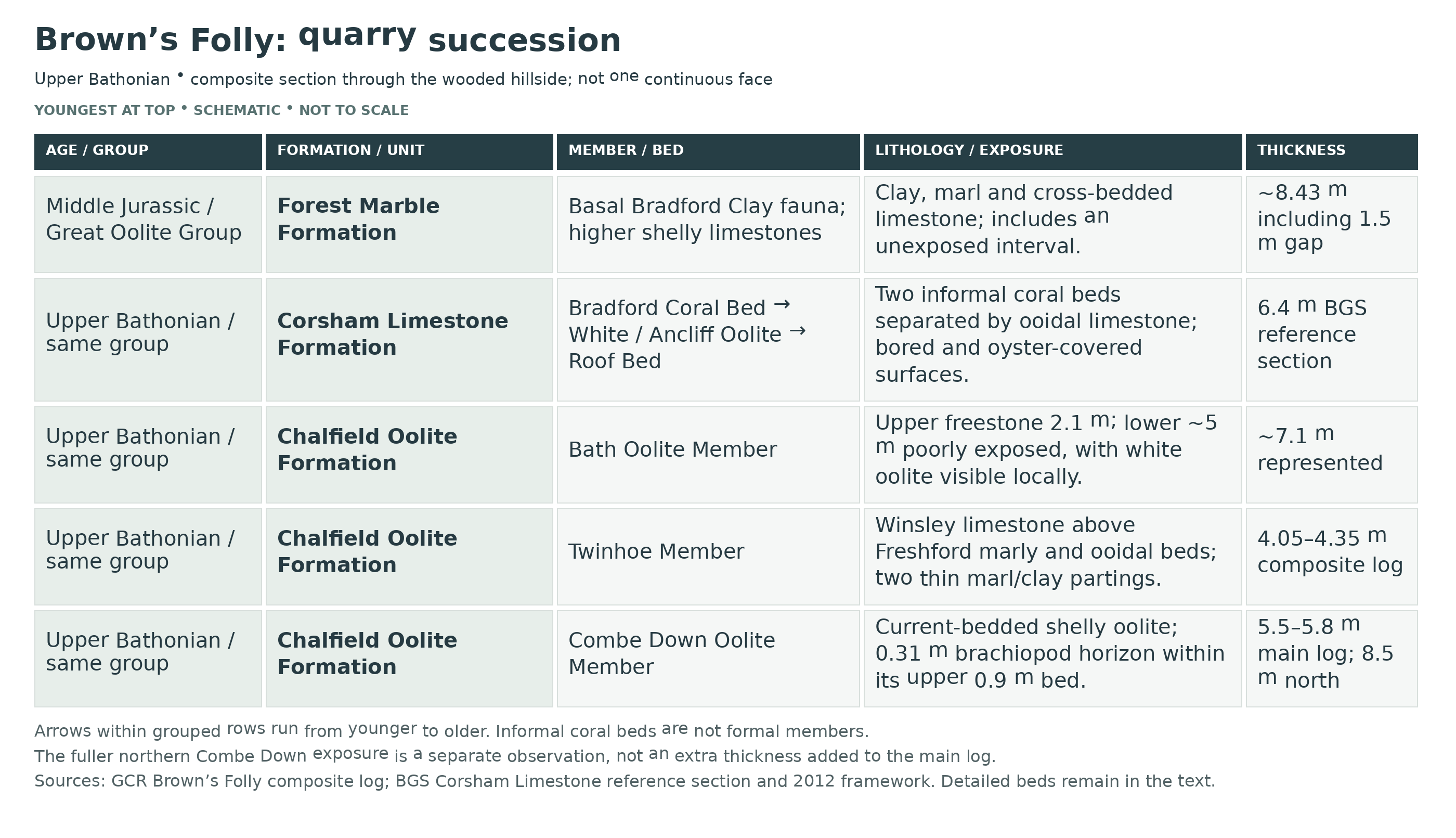
Detailed geology and bed-by-bed succession
Detailed geology, measured beds and historical exposures at Brown’s Folly
The succession below follows the published composite section from its oldest exposed rocks upwards. It combines crags between ST 795 663 and ST 794 652, with the tower at ST 7947 6606. It is not a promise that every layer is visible from the present walking route. Historical trail numbers are discussed separately, and closures and current reserve instructions take priority over old descriptions.
GREAT OOLITE GROUP
The local section is Upper Bathonian. Older accounts use Great Oolite Formation for the rocks now placed in the Chalfield Oolite Formation, and Upper Rags Member for the body now called Corsham Limestone Formation. “Bradfordian” is historical terminology for part of the local succession. No diagnostic ammonite succession is known from Brown’s Folly itself; regional records underlie the zonal interpretation, and the precise boundary between Retrocostatum and Discus zones is not fixed here to an individual bedding plane.
Chalfield Oolite Formation
Combe Down Oolite Member
Main lower ooidal limestone, 4.6–4.9 m. Fawn, fairly hard limestone forms a massive, current-bedded unit with numerous thin concentrations of shell debris. The rock was formerly worked as building stone. Its abundant broken shell material should not be mistaken for a bed in which complete shells are uniformly common.
Upper detrital ooidal limestone, 0.9 m. A finer-grained fawn limestone has branching burrows and a sharp lower boundary, although it remains attached to the underlying bed. Its middle contains the separate brachiopod concentration described next.
Brachiopod-rich interval within the 0.9 m bed, 0.31 m. This thickness is included in the surrounding bed, not added to it. Kallirhynchia cf. superba and abundant Obovothyris cf. obovata record a colonised seafloor during a period of relative stability. The species names remain provisional.
Fuller northern exposure. Crags at ST 7943 6634, about 300 m north of the tower, expose 8.5 m of Combe Down Oolite. This was considered approximately 1 m short of the full local thickness. It is a different section from the 5.5–5.8 m represented by the two main-log beds above, so the measurements must not be added together. Locally planar, bored and oyster-encrusted surfaces and well-developed branching burrows mark stabilised or hardened sediment.
Twinhoe Member
Basal clay and marl, 0.10 m. Yellow-brown clay and marl rests sharply on the Combe Down limestone and locally fills pockets in it. The contact records a pause before the next phase of sedimentation; this bed is not an ironshot limestone throughout.
Lower Freshford-facies rubbly limestone, 0.7–0.8 m. Buff, relatively soft, marly limestone is rich in shells and larger coated grains known as pisoids. Many bivalves survive as moulds and casts in the rubbly rock.
Middle Freshford-facies limestone, 1.1 m. Fawn to yellow detrital limestone is marly and pisoidal, with irregular bedding. No separate species list is assigned to this individual interval in the published log.
Upper Freshford-facies ooidal limestone, 0.9–1.1 m. Cream-coloured, relatively soft limestone contains coarse ooids, a marly component and dispersed shell debris.
Ochreous marl parting, 0.15 m. An ochre-coloured marl has a sharp base above the preceding ooidal limestone. It is a distinct parting rather than an extra thickness assigned to either neighbouring limestone.
Winsley-facies limestone, 1.1 m. Hard, yellowish, massive detrital limestone caps the member. The change from the Freshford facies to this unit forms part of a wider transition towards quieter or deeper shelf-margin and foreslope conditions. Freshford and Winsley are facies names here, not additional formal members.
These six measured intervals total approximately 4.05–4.35 m. A rounded thickness of 4 m is therefore approximate. Regional comparisons with the Frome Clay explain environmental changes, but do not demonstrate that a separate Frome Clay unit is exposed in this local measured section.
Bath Oolite Member
Lower poorly exposed interval, approximately 5 m. The published log records a gap in exposure, with white ooidal limestone visible in places. This is not a measured clay bed and does not by itself establish a break in geological time.
Upper freestone, 2.1 m. Fine-grained, relatively pure ooidal limestone was mined as building stone. Its slightly bored upper surface records a pause before deposition resumed. The building-stone name Farleigh Down Stone belongs to this local stone, not a separate formation.
Basal contact and separate quarry observations. The boundary with the Twinhoe is sharp, with Bath Oolite sediment locally extending down into the older rock. Historical trail Site 1 exposes about 2 m of Bath Oolite below the Roof Bed; Site 10 described 4.5 m of continuous Bath Oolite in a mine opening. These are separate local observations within the member, not extra intervals to add to the roughly 7.1 m represented by the composite log. Mines must not be entered.
Corsham Limestone Formation
Current BGS terminology recognises this formation above the Chalfield Oolite and below the Forest Marble. Brown’s Folly is a reference section with a full thickness of 6.4 m. The individual GCR ranges below sum to approximately 6.0–7.1 m and describe local variation rather than a reason to replace the BGS reference value. Corsham Coral Bed, Ancliff or White Oolite and Bradford Coral Bed are informal divisions; they are not formal members.
Corsham Coral Bed or Roof Bed, 1.5 m. Hard, massive, pale-buff coralline limestone includes coarse ooids and shell debris. Its upper surface is strongly bored and encrusted by oysters. It formed the quarrymen’s roof above the Bath Oolite. The characteristic discrete reef-knolls of the Corsham railway cutting are not demonstrated in this basal bed at Brown’s Folly.
Intervening ooidal limestone, 1.8–2.6 m. Creamy-buff, detrital ooidal limestone is fairly massive, becoming locally fine-grained and marly near its top. Burrows occur within it and its upper surface is locally bored. White Oolite and Ancliff Oolite are names used for this interval. A published site photograph shows large-scale south-directed cross-bedding below the Bradford Coral Bed.
Bradford Coral Bed, 2.7–3.0 m. Hard brown shelly limestone weathers into ragged or cavernous rock, with some portions reduced to ochreous rubbly marl. Corals, brachiopods, large thick-shelled bivalves and oysters occur. The top is oyster-encrusted; the base locally cuts channels into the underlying ooidal rock, but elsewhere grades into it. A reef-knoll up to 3 m thick is documented about 45 m north of the tower. This coral bed lies below, and is distinct from, the Bradford Clay-fauna horizon.
Coral preservation and qualified identifications. Tucker’s locality observations include calcite replacement of coral skeletons, bivalve borings and a possible Thamnasteria colony. An Isastrea-type thin-section came from Ron Smith’s Brown’s Folly collection, and a Bradford Coral Bed bivalve was compared with Plagiostoma. The proposed identities are provisional. Coral “geodes” illustrated from Park Lane Quarry and the separate Combe Down coral fauna are not Brown’s Folly records.
Forest Marble Formation
Basal Bradford Clay-fauna horizon, 0.23 m. Grey fossiliferous clay rests sharply on the oyster-covered top of the Bradford Coral Bed. It contains Apiocrinus, Digonella digona, numerous rhynchonellid brachiopods and oysters. The traditional Bradford Clay name identifies this local horizon; it is not a separate modern formation.
Marl above the basal clay, 0.30 m. Brown sandy marl grades down into the clay and upwards into irregular, shelly, marly limestone. It is separately measured from the 0.23 m clay beneath.
Lower cross-bedded limestone, 1.5 m. Buff limestone contains detrital grains and ooids arranged in cross-bedding. Bedding surfaces preserve fossils, including Digonella digona.
Unexposed interval, approximately 1.5 m. The log records a gap between the lower limestone and upper flaggy package. No particular lithology or fossil assemblage is assigned to this hidden interval.
Upper flaggy limestone package, approximately 4.9 m. Brown, shelly limestone splits into flags. Its lower 3.4 m is cross-bedded; the higher part is shown with more nearly horizontal bedding in the published figure.
Lower cross-bedded portion within the flaggy package, 3.4 m. This is included within the approximately 4.9 m package, not an additional thickness. The remaining roughly 1.5 m is the difference between rounded values, rather than a separately quoted measured bed.
The Forest Marble intervals represent approximately 8.43 m including the unexposed 1.5 m, while the described rock intervals total approximately 6.93 m. A rounded 7 m describes the exposed rock, rather than the complete represented interval or the regional formation thickness.
Historical trail: interpreting separate exposures. The following site numbers refer to the 13-station geological trail reproduced in the 2018 field guide. They are not the exposure numbers in Smith’s 1986 survey or the A–I points in the current Cotswolds walk. Sites 5 and 6 changed in 2003 for safety, and old numbers should not be used as present-day navigation.
Historical trail Site 1. Upper Bath Oolite, Roof Bed and lower White Oolite occur together. Quarry tool marks and a cemented fine-gravel or breccia fissure fill are also described. The fill is much younger than the Jurassic bedrock and has only tentatively been considered Pleistocene.
Historical trail Site 2. The published trail chart places this exposure in the higher Forest Marble. It does not supply a separate measured bed log.
Historical trail Site 3. Another Forest Marble exposure extends somewhat lower on the published chart than Site 2. No new thickness is inferred from the drawn range.
Historical trail Site 4. White Oolite passes upwards through the upper Corsham Limestone and basal clay into Forest Marble. The historical account describes a mine-collapse hollow, cross-bedding and a brown clay near the base of the Forest Marble, with loose crinoid pieces and brachiopods below. The clay face must not be dug.
Historical trail Site 5. Upper Bath Oolite, Roof Bed, White Oolite and upper Corsham rocks are represented. A detached Roof Bed slab carries oysters and borings; shelly ooidal rocks show vertical burrows. The slab must not be hammered or walked on, and the bricked mine opening is not an access route.
Historical trail Site 6. The trail chart shows Combe Down Oolite extending into the lowest Twinhoe. This is the revised station, not permission to return to the former unsafe Site 5.
Historical trail Site 7. The plotted range extends from upper Bath Oolite through the Roof Bed and White Oolite into upper Corsham rocks near the Forest Marble base. Fossiliferous scree and a brown clay near the top are described. Older accounts associate a patch reef with Site 7, while Tucker’s later figure uses Site 8; the numbering must not be treated as a precise bed correlation.
Historical trail Site 8. Upper Corsham Limestone and the lowest Forest Marble are shown. Tucker illustrates the Bradford Coral Bed above south-dipping, cross-bedded Ancliff Oolite at this station.
Historical trail Site 9. The chart records a short uppermost Corsham interval close to the Forest Marble base. Smith also describes an isolated block with complex cross-bedding, without enough information to assign that block to a finer named bed.
Historical trail Site 10. Bath Oolite, the Roof Bed and White Oolite occur around an old mine opening. Historical observations include cambering, open fissures or gulls and complicated displacement, as well as the separately reported 4.5 m Bath Oolite exposure. Current mine-entry restrictions apply.
Historical trail Site 11. The chart shows a broad Combe Down and Twinhoe interval. Large Combe Down blocks have slipped above weaker Fuller’s Earth clay. This explains the slope structure; it does not insert an exposed Fuller’s Earth bed into the composite GCR log.
Historical trail Site 12. Combe Down Oolite is shown, without a separately published measured station log in the cited account.
Historical trail Site 13. Upper Combe Down Oolite displays particularly clear burrows and cross-bedding.
Earlier exposure survey. Smith’s 1986 numbers identify a different set of observations. Exposure 2 records Bath Oolite, Roof Bed, shelly oolite, quarry marks and the younger fissure fill. Exposure 5 shows brown, shelly, cross-bedded Forest Marble. Exposure 19 describes a collapse hollow, cambered Forest Marble and poorly exposed Bradford-type clay with crinoid fragments and rarer brachiopods. These observations locate features within the same succession; they are not extra numbered beds.
In the same 1986 survey, Exposure 10 contains a bricked entrance below the Roof Bed, burrowed cream oolite, cavernous upper beds and a detached bored, oyster-covered slab. Exposure 11 shows a similar succession with conspicuous burrows and borings. Exposure 12 contains a small Upper Rags reef-knoll already affected by weathering and hammering, with fossiliferous talus. Exposure 16 describes Bath Oolite, Roof Bed and overlying ooidal limestone in disrupted and faulted rock around a short mine gallery; this is historical geology, not a recommendation to enter it.
Exposure 14 of the 1986 survey records Twinhoe over Combe Down, a brachiopod band around their junction, cross-bedding, shell bands and slipped blocks. Exposure 15 shows Combe Down cross-bedding, sometimes obscured by vegetation. The more precisely measured brachiopod horizon remains the 0.31 m interval within the upper Combe Down bed described above.
Features on the current walk. Route points C–I highlight shell-rich Forest Marble above cross-bedded older rocks, Bath Oolite at old entrances, burrowed “sponge rock”, Roof Bed and White Oolite blocks, an oyster-rich coral patch reef and detached slabs. The so-called sponge holes are interpreted as crustacean burrows. Where the route gives no precise host bed for a detached block, none is assigned here. The current route prohibits mine entry and face hammering and directs visitors away from ash-dieback closures.
Stone-provenance and laboratory records. Tucker and colleagues’ 2020 study compared Brown’s Folly material with Roman building stone from Bath. Their Combe Down sample beds A and B supplied 26 and 33 analyses respectively, with 28 analyses in the Bath Oolite sample set. A and B are analytical sample labels, not formally named beds or a measured local sub-division. A large Lewis-bolt hole at the site was interpreted as Roman, but the work does not establish that every surviving quarry is Roman or that all Roman Bath Stone came from Brown’s Folly.
References.
Wyatt (2002), Brown’s Folly, Geological Conservation Review, including the section after Green and Donovan (1969).
Barron, Lott and Riding (2012), BGS stratigraphical framework, Chalfield Oolite and Corsham Limestone.
Smith (2006), geological-trail conservation account.
2018 GCG/HoGG field guide, trail-position chart.
Tucker (2022), corals in Bath Stone and their preservation.
Tucker and colleagues (2020), sources of Roman Bath Stone.
Safety
Keep well away from high, undercut or fractured quarry faces and from the ground immediately below them. Loose scree, fallen blocks, steep slopes, steps and muddy paths can be unstable. Ground-level scree is not automatically safe merely because it lies below a collecting exposure.
Do not enter mines, bricked openings, unmarked or unsafe collapse hollows, or closed woodland areas. Follow the current designated route, ash-dieback notices and open-path diversions. The old geological trail has changed over time, including the relocation of an unsafe station, so do not use an old numbered itinerary as permission to approach a hazardous face.
Keep children close, wear footwear with a good grip and take a charged phone. Avoid climbing to clay seams or removing supporting rock, and keep dogs on a lead in accordance with the reserve’s instructions.
Equipment
A camera, hand lens, small scale, notebook and the current reserve route are the most useful equipment. Sturdy boots are preferable to smooth-soled shoes on the steep woodland paths. Hammering samples from rock faces is prohibited by the current walk instructions, and digging tools are inappropriate for a non-destructive visit.
If the landowner permits a small naturally loose specimen to be taken, support it in soft wrapping inside a rigid box and label the precise find location. Keep fragile shell-rich pieces separate from heavy limestone.
Cleaning And Treating
Photograph and label authorised loose material before cleaning. Start with a soft, dry brush to remove loose dirt; clay-rich pieces and weathered shell surfaces may crumble if soaked or scrubbed. Stop if the fossil surface begins to lift.
The limestone, shells and much of the coral skeleton are carbonate, so acids can remove the fossil as well as its matrix. Avoid household acids, bleach and varnish. Do not break a colony or force a shell from hard limestone simply to improve its appearance; unusual specimens and fragile crinoid material are best assessed before preparation.
Identify Your Finds
Need help identifying a fossil? Share clear photos, where you found it and its size with the community.
Further Reading
Geological Conservation Review: Brown’s Folly and its measured section
BGS Lexicon: Corsham Limestone Formation
BGS Lexicon: Chalfield Oolite Formation
BGS framework for the Great Oolite Group
Ron Smith: conservation and development of the geological trail
Tucker and colleagues: Roman Bath Stone and Brown’s Folly samples
Cotswolds National Landscape: current geology walk
Avon Wildlife Trust: current reserve information
Natural England: Brown’s Folly SSSI citation
Access Rights
Brown’s Folly is a Site of Special Scientific Interest with important geological exposures, grassland, woodland and bat interests. Avon Wildlife Trust manages the reserve. Use its open paths and follow current notices; public walking access does not itself give permission to remove fossils.
The current geology walk prohibits hammering samples from rock faces and entering underground quarries. Do not dig the Bradford Clay horizon, disturb the oyster-covered slab or remove material from protected exposures. Establish the landowner’s current collecting conditions before taking naturally loose specimens; any necessary protected-site consent is separate from ordinary visitor access.
It is important to follow our ‘Code of Conduct’ when collecting fossils or visiting any site. Please also read our ‘Terms and Conditions‘
Links
♦ Fossil Discussions
♦ Fossil Articles
♦ Buy Fossils, Tools and Equipment
♦ Buy Crystals, Meteorites, and Artefacts
♦ Join Fossil Hunts
♦ UK Fossils Network


