
Overview
Directions
- Approach from Meon Shore beside Titchfield Haven, rather than private roads or gated farm approaches at Brownwich Farm and Chilling.
- From the M27, Junction 9, follow the A27 towards Titchfield and then the B3334 towards Stubbington. Continue towards the coast and Meon Shore, west of the bird reserve and lighthouse. The original guide records parking and toilets here.
- The narrow Meon Road is an alternative approach, subject to current restrictions and works. A dated roadworks order does not establish a continuous closure; check the live arrangements before travelling.
- From Meon Shore, walk west towards Brownwich Cliff, then Chilling Cliff farther on, using only open public routes. This can be a long, stony walk; tides and erosion may interrupt beach passage. Do not divert through private farm gates.
- Original locality reference: 50.819042, -1.248995. This is historical guide context, not a newly verified car-park entrance.
Location photographs
Swipe to browse · Select a photograph to enlarge


Fossil Hunting
The strongest local fossil evidence concerns Eocene bivalves and gastropods in glauconitic sandy sediment and cemented blocks. Weathered surfaces often show moulds rather than intact shells. Loose brown nodules can be conspicuous on the foreshore but are not always plentiful.
Some weathered calcareous nodules occur within the local cliff sediment; other loose cemented blocks may have come from shallow bedrock or offshore exposures. Once a block has been moved by the sea, its exact bed cannot be assumed from where it now lies. Record the matrix and setting and inspect already exposed surfaces rather than breaking hard blocks indiscriminately.
The earlier guide reported brachiopods, excellent intact shells inside nodules and occasional mammal bones from the brickearth, while acknowledging the absence of a formal local mammal study. Those claims remain unverified historical observations. They do not establish a dependable mammal yield or a secure species list.
The well-known Fisherton mammal assemblage near Salisbury and the vertebrate fauna at Lee-on-the-Solent are different localities. Neither supplies a Brownwich fossil checklist. Flint pebbles and sarsens are geological material rather than fossils, while any suspected Palaeolithic artefact belongs to an archaeological context and should be recorded and reported for specialist advice rather than treated as an ordinary fossil souvenir.
Fossil photographs
Swipe to browse · Select a photograph to enlarge


Discoveries and milestones
Discover why the Brownwich terrace deposits matter and how erosion has changed their exposure.
1992–1993 – Terrace deposits gain protected recognition
Notification and confirmation of the Lee-on-the-Solent to Itchen Estuary SSSI recognised the Brownwich terrace deposits and their archaeological interest, alongside different fossil interests elsewhere in the site.
2008 – Storm erosion reveals changing cliff sections
March storms produced conspicuous erosion in the Chilling reach, illustrating how rapidly the exposures and access conditions can change.
Geology
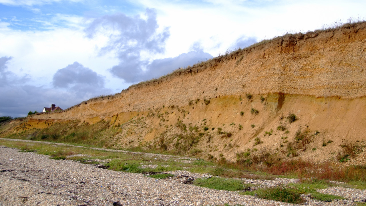
The lowest exposed bedrock belongs to the Lutetian Selsey Sand Formation of the Bracklesham Group. It comprises glauconitic marine sandy clay and sand, with bioturbation, molluscan moulds and locally cemented material. Weathering can turn the greenish glauconitic sediment brown.
An erosional surface separates that Eocene substrate from much younger river terrace deposits. These contain abundant subangular flint, derived rounded Eocene pebbles and local sarsens. Bedding, scours and cold-climate disturbance record the former Solent river system and later modification of its deposits. Historical mapping assigns the gravel to Terrace 2, but a precise marine-isotope-stage age is not securely established for this cliff.
Brown silty brickearth and soil cap the gravels. Mineral evidence suggests a possible contribution from Chalk-derived material, while wind-blown versus river-derived origins remain uncertain. The often quoted approximately 7 m is cliff height, not a measured thickness of one formation. The inland Chilling Farm borehole is not a substitute for a local cliff log.
Detailed geology and bed-by-bed succession
Geology and stratigraphy
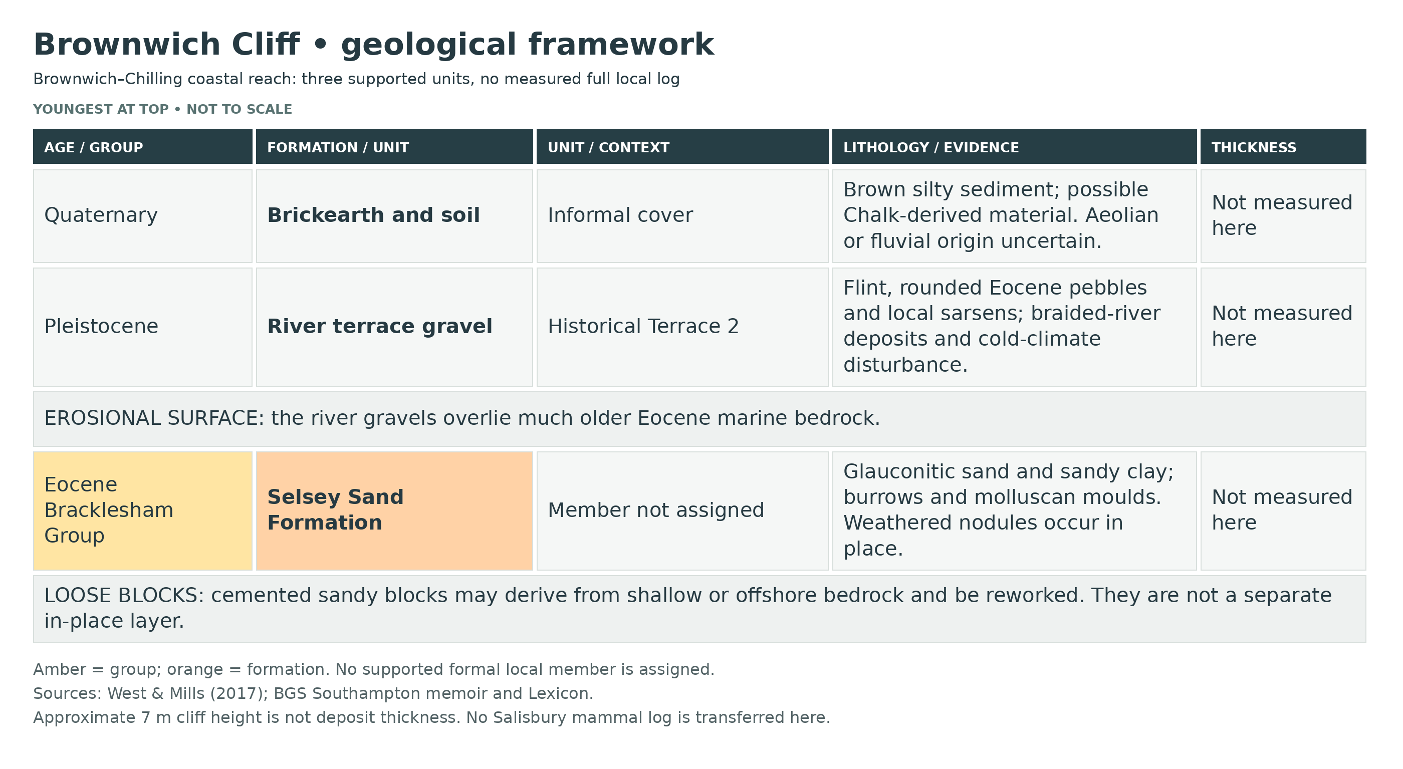
Brownwich and Chilling expose Quaternary river deposits above older Eocene marine sediment. The deposits record two very different environments: a subtropical shallow sea followed, after a long hiatus, by the former Solent river and cold-climate landscape modification.
Quaternary cover — Pleistocene terrace deposits and younger soil
Brickearth and soil cover
Brown silty sediment caps the gravels. Mixed-layer clay and mineral evidence suggests a possible contribution from Chalk-derived material. Aeolian versus fluvial origin remains uncertain, with later soil development modifying the deposit.
River terrace gravel
The historical BGS mapping assigns these deposits to Terrace 2. Dominant subangular flint, derived rounded Eocene pebbles and local sarsens occur in a succession interpreted as a seasonally active braided river. Bedding, scours, cryoturbation and ice-wedge structures record deposition and later cold-climate disturbance. They overlie an erosional surface. A precise marine-isotope-stage age is not securely assigned to this exact cliff.
BRACKLESHAM GROUP
Selsey Sand Formation
Selsey bedrock and cemented blocks
Glauconitic sandy clay and sand preserve bioturbation and molluscan moulds. Weathered calcareous nodules are documented within local cliffs. Separately, loose cemented sandy blocks may derive from shallow bedrock or offshore exposures and can be reworked on the beach; a loose block is not a bed observed in place.
Age, dimensions and source limits
The Selsey Sand Formation is Lutetian. The terrace deposits are Pleistocene, but an exact stage assignment cannot safely be transferred from a neighbouring site. The often quoted approximately 7 m describes cliff height, not formation thickness. The Chilling Farm borehole records a much deeper regional succession and does not establish a stack of exposed Brownwich beds. A finer named member or bed subdivision has not been securely established for this exposure.
References
West & Mills (2017), Chilling Cliff, Brownwich Cliff and Hill Head
Edwards & Freshney (1987), Geology of the country around Southampton, sheet 315 memoir
Natural England, Lee-on-the-Solent to Itchen Estuary SSSI citation
BGS Lexicon: Selsey Sand Formation
Safety
Check tide times, water levels and the return route before walking west. Do not assume the cliff base stays dry at high tide or that cut-off is only a winter problem.
Cliff falls and landslips can occur without warning. Keep well clear of the cliff toe and eroding cliff-top edges, including on the longer walk towards Chilling. Avoid fresh falls and unstable or waterlogged ground.
Equipment
Use sturdy footwear, a camera, hand lens, notebook and a map suitable for the coastal approach. Padding and rigid containers help support any permitted fragile find. A heavy hammer is not a routine requirement and must not be used to damage protected faces or sea defences. Eye protection is essential if separately authorised preparation ever involves impact tools.
Cleaning And Treating
Molluscan moulds and fragile shell surfaces can separate from hard cemented matrix. Begin with minimal dry brushing and support the whole specimen rather than trying to force the nodule apart. Seek skilled mechanical preparation where the fossil and matrix fracture together.
Do not automatically coat finds with PVA or varnish. Consolidation should be specimen-specific and reversible where needed; scientifically important material is best left unprepared for specialist assessment. Do not acid-clean calcareous fossils or nodules.
Identify Your Finds
Need help identifying a fossil? Share clear photos, where you found it and its size with the community.
Further Reading
West & Mills (2017), Chilling Cliff, Brownwich Cliff and Hill Head
Edwards & Freshney (1987), Geology of the country around Southampton, sheet 315 memoir
Natural England, Lee-on-the-Solent to Itchen Estuary SSSI citation
BGS Lexicon: Selsey Sand Formation
Access Rights
Brownwich’s terrace deposits form part of the Lee-on-the-Solent to Itchen Estuary SSSI. The joint citation includes different interests elsewhere; Brownwich’s terrace and archaeological interest must be distinguished from Lee-on-the-Solent’s fossil fauna. Use public access from Meon Shore and respect private farm roads, gates and current closures. SSSI designation does not itself grant collecting rights. Obtain the relevant permission before sampling; do not dig protected faces or remove suspected artefacts without specialist advice.
Archived Natural England site citation. Current access and permission requirements must be checked separately.
It is important to follow our ‘Code of Conduct’ when collecting fossils or visiting any site. Please also read our ‘Terms and Conditions‘
Links
♦ Fossil Discussions
♦ Fossil Articles
♦ Buy Fossils, Tools and Equipment
♦ Buy Crystals, Meteorites, and Artefacts
♦ Join Fossil Hunts
♦ UK Fossils Network


