
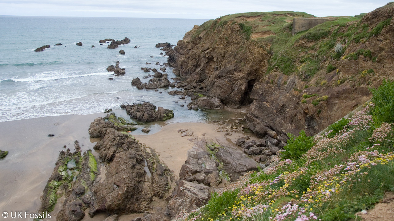
Overview
Directions
- From the A39, take the A3072 or A3073 downhill into Bude and follow town-centre signs towards Bencoolen Road. The original approach turns across the river bridge at the mini-roundabout, then left within about 100 m towards the Tourist Information Centre and Crescent car park.
- Cornwall Council lists Crescent car park at EX23 8LE. Follow current parking signs and payment information; the postcode identifies the car park rather than a fossil exposure. The earlier guide’s visitor-starting-point coordinates are 50.82691°N, 4.54599°W.
- From the Tourist Information Centre area, follow the established pedestrian route along the canal wharf towards Summerleaze Beach, roughly 500 m away. The Sea Pool and its adjoining cliffs are beyond the northern side of the beach. Do not treat the pool surroundings as permission to approach the fish-bearing overhang.
- The breakwater is a separate observation point beside the harbour. View fossiliferous blocks only from an open, safe pedestrian position and obey closures; do not climb onto exposed blocks or enter wave-washed sections.
- For the Bude fossil fish, visit The Castle Heritage Centre by the town and canal. The museum advertises free entry; check its current visitor information for opening arrangements before travelling.
- Original guide locality reference: 50.830533°N, 4.549466°W. If using public transport, check a current timetable rather than relying on the earlier guide’s bus frequency or journey time.
Location photographs
Swipe to browse · Select a photograph to enlarge


Fossil Hunting
There are two distinct fossil stories at Bude. The natural sandstone and shale around the Sea Pool belong to the Carboniferous Bude Formation; a particular dark shale has yielded important fish. The crinoids and corals visible in the breakwater occur in imported limestone blocks. They do not establish a coral-bearing limestone layer within the natural Bude Formation, and the two types of evidence should be recorded separately.
The fish-bearing horizon is Saturday’s Pit Shale, historically described at the swimming-pool locality. Its dark fine-grained sediment contains carbonate concretions, some preserving Cornuboniscus budensis, a small ray-finned fish. The BGS measured 3.96 m of shale here, with concretions up to 0.15 m across approximately 0.9 m above the base. These dimensions describe the historical scientific section; the low fossil horizon is not an invitation to search beneath the unstable cliff or open its nodules.
Fish are recognised by anatomy rather than colour alone. Ordered scales, fin rays and connected skeletal elements are stronger evidence than an isolated dark patch or shiny flake. Some remains may preserve relief inside a concretion, while others are fragmentary or flattened. The BGS local fossil register includes Acanthodes wardi, palaeoniscid scales and indeterminate acanthodian material as well as Cornuboniscus. A fragment cannot be assigned to the famous Bude fish merely because it came from dark shale. White’s original account also records Elonichthys aitkeni in the Bude fauna. He described external moulds, sometimes uncrushed, which preserve fine anatomical detail; such preservation is different from an isolated scale impression.
The best public opportunity to examine the Bude fish is the display at The Castle Heritage Centre. The museum currently advertises free entry and interprets the town’s natural and human history. Check opening arrangements before visiting. The display allows appreciation of the preserved detail without disturbing an important fossil-bearing exposure.
A separate local horizon, Tom’s Cove Shale on the Bude Haven foreshore, has yielded pyritised fish from nodules. This is not another name for Saturday’s Pit Shale, nor does the record identify all of those remains as Cornuboniscus. Fine sandstone and siltstone in the measured pool section also contain small plant fragments. These may appear as coherent carbonaceous films or impressions; scattered dark mineral patches and fragmented sediment are not sufficient evidence for a named plant.
The limestone blocks offer a more readily visible fossil display. Crinoid columnals are the small disc-like pieces of the stems of marine echinoderms; cut across a block, they may appear as circles with a central opening. Solitary-coral sections can show a radiating internal pattern. Examine existing weathered surfaces from a safe standing position and photograph them with a scale. The earlier guide also noted fossiliferous limestone in the corner stones of old Lower Wharf buildings nearest the sea; inspect only surfaces visible from public access.
The imported limestone’s precise quarry and geological age are not established here. Keep photographs of its fossils labelled as building-stone observations rather than natural Bude Formation finds. Do not hammer, prise or remove stone from sea defences or buildings. On the natural shore, record a promising exposed fossil with its position and surrounding rock, then seek appropriate museum or site-owner advice before any intervention.
Fossil photographs
Swipe to browse · Select a photograph to enlarge


Discoveries and milestones
A chronological record of fossil discoveries, geological research and site history at Bude.
1930s – The Bude fossil fish discovered
The fish later named Cornuboniscus budensis was discovered at Bude during the 1930s. The museum’s account supports this decade without establishing a more precise first-find date.
1939 – The Bude fish formally described
E. I. White published the original scientific description of Cornuboniscus budensis. This is the taxonomic publication date, distinct from the earlier discovery of the material.
1979 – Pool section and fossil records published
Freshney, Edmonds, Taylor and Williams described Saturday’s Pit Shale, the complete underlying local sandstone–shale section and the pool-area fish records in the Geological Survey memoir for Bude and Bradworthy.
1987 – Bude Coast given SSSI protection
Bude Coast SSSI was notified on 2 October, recognising the nationally important fold and fault exposures of the Bude Formation around the town as well as its coastal habitats.
By 2012 – The fossil fish on display in Bude
A contemporary local newsletter records the fossil-fish display at The Castle. This establishes that it was already being shown by 2012, without implying an independently verified date of return or a count of all surviving specimens.
Geology
Bude’s natural coastal rocks belong to the Bude Formation of the Holsworthy Group. Thick sandstone beds alternate with siltstone and shale, creating resistant ledges separated by weaker, more deeply weathered intervals. The formation has a regional Langsettian–Bolsovian, late Carboniferous age range, but that range is not a precise date for every exposure beside the town. The historically important fish occur in a specific shale within this much larger succession.
The sandstones preserve changing conditions during sediment transport and deposition. Some beds are massive, whereas others contain current-generated cross-lamination or migrating-ripple structures. Thin shale and siltstone record quieter sediment accumulation between sandier events. Load casts and flame structures formed as sand and mud deformed while still soft, and slumped bands record movement before complete consolidation. These early structures must be separated from the folds and faults that formed later in the rock’s history.
The BGS formation model combines a large lake on a broad shelf, river-fed sediment flows, storm-wave activity and intermittent marine incursions. Other studies have emphasised deltaic, shallow-marine and gravity-flow processes. These interpretations address different observations and scales; the town exposure should not be reduced to a claim that every bed formed in one uniform deep sea or freshwater lake. The local measured log supplies evidence of currents, quiet-water intervals and soft-sediment disturbance without resolving every environmental question.
Saturday’s Pit Shale is valuable both as a marker horizon and for its fish-bearing carbonate concretions. At the historical swimming-pool section, thin cross-laminated sandstone lies within the 3.96 m shale package, above the principal recorded concretion level. Beneath it, the memoir describes a varied sandstone–shale succession, including very thin muddy breaks, plant-bearing siltstone and slumped sand. The complete nineteen-entry inventory is retained below rather than replacing it with a general sandstone-and-shale label.
Variscan folding and faulting subsequently tilted, repeated and displaced the layers. BGS records repeated Saturday’s Pit Shale outcrops around the pool and a pronounced fault passing beneath its outer wall. A bed seen again along the shore may therefore be a structural repetition, not a new fossil horizon. The cliff geometry, the original stratigraphic thickness and the modern shore route are different things.
The limestone used in the breakwater has a separate history. It was brought to Bude as building material and contains a marine fauna unlike the natural fish-bearing shale. Its fossil content is useful for observation, but neither its exact source nor its geological age is established by its present position in the harbour structures.
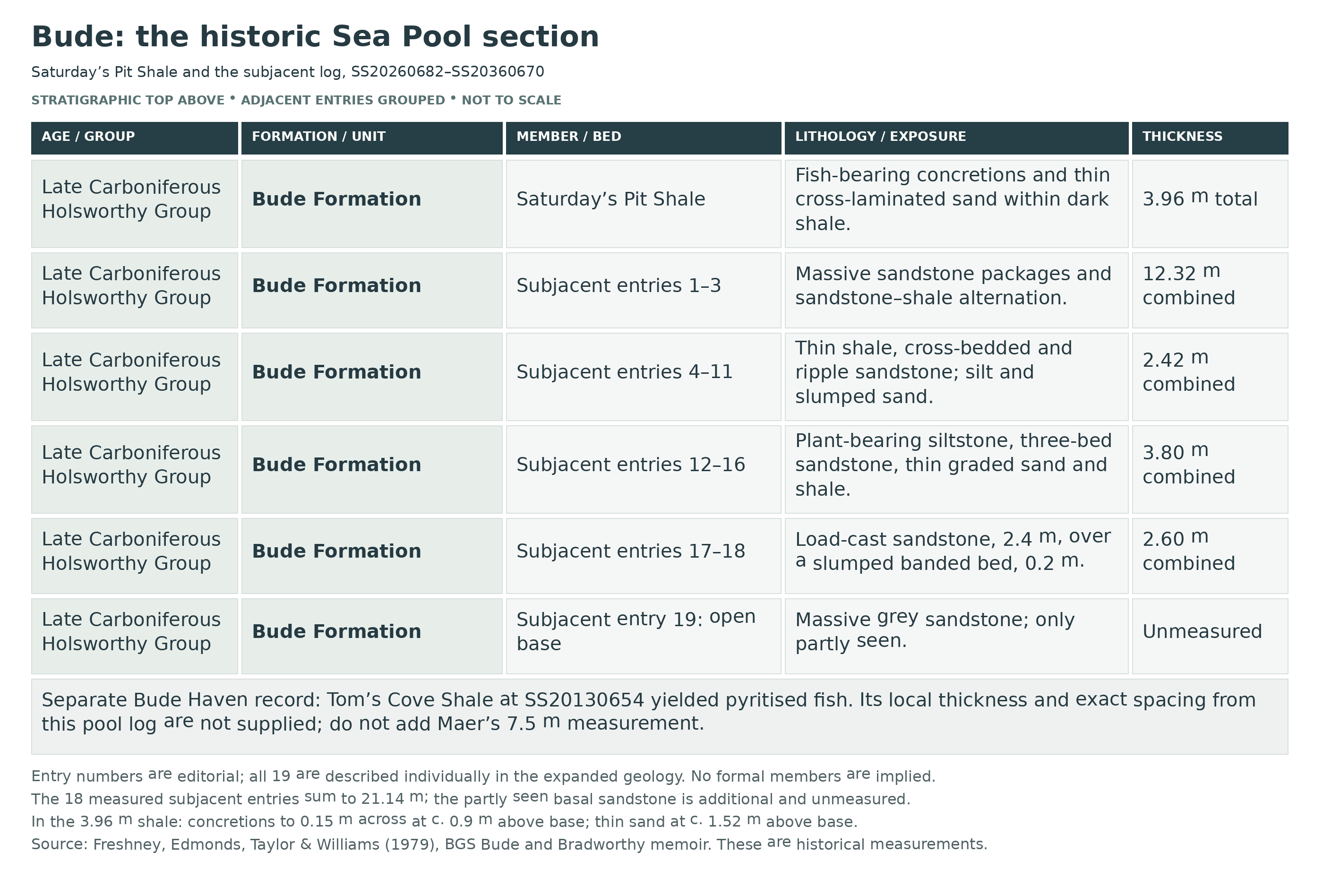
Detailed geology and bed-by-bed succession
Detailed geology and stratigraphy of Bude, including the limits of local correlation.
This account concerns Bude Haven, Summerleaze, the Sea Pool and the adjacent historic measured section. The pool log runs from SS20260682 to SS20360670. Separate measurements at Northcott Mouth, Maer High Cliff, Sandy Mouth and farther north are not combined into it. Grid references locate scientific records, not safe or permitted collecting positions.
HOLSWORTHY GROUP
The formal parent group includes the Bude Formation. It belongs to the wider Culm succession of south-west England. Group-scale thickness and basin history provide context only and must not be read as measurements of the cliffs beside the Sea Pool.
Bude Formation
Sandstone, siltstone and mudstone form the natural shore section. The formal formation has a regional Langsettian–Bolsovian age range and a calculated coastal thickness of at least 1,290 m; neither is the precise measured span or thickness of the town exposure. Saturday’s Pit Shale and Tom’s Cove Shale are named subordinate horizons, not formal members. Imported limestone blocks are excluded from this stratigraphic hierarchy.
Saturday’s Pit Shale at SS20260682: 3.96 m
The BGS description gives a total of 3.96 m of shale at Saturday’s Pit, the historic swimming-pool locality. It is the local dark fish-bearing shale package. The internal sandstone and concretions described below lie within this total and must not be counted as extra thickness above it.
Saturday’s Pit Shale: laminated concretions
Laminated carbonate concretions, up to 0.15 m across, occur about 0.9 m above the base. Nodules from this locality have yielded Cornuboniscus budensis. The 0.15 m dimension is concretion size, and 0.9 m is its height above the base; neither is the thickness of an independently measured fossil band. No thicknesses are supplied for separately defined shale sub-beds below or above this level.
Saturday’s Pit Shale: thin cross-laminated sandstone
Thin cross-laminated sandstone beds occur approximately 1.52 m above the shale’s base. The memoir gives their position but no individual thicknesses here. They record brief sandy current deposits within the otherwise shale-rich package; the surrounding remainder must not be subdivided using invented bed boundaries.
Pool-area fish register and identification limits
At the cliff-base record SS20260694, collection DEB6435–60 includes Cornuboniscus budensis, Acanthodes wardi, palaeoniscid scales and a queried eurypterid. At the north-east corner of the pool, SS20270682, fossil-register locality 23 includes Cornuboniscus, indeterminate acanthodian remains and another queried eurypterid record. The queries and indeterminate identifications remain part of the evidence; they are not confirmed extra species.
White’s Bude fauna and preservation
White’s 1939 account describes Acanthodes wardi, Elonichthys aitkeni and the new genus and species Cornuboniscus budensis from Bude. The fossils were preserved as external moulds, sometimes without crushing, allowing fine anatomical details to be studied. The unusual pectoral-fin structure was central to the description of Cornuboniscus. This historical fauna is distinguished from the more specifically located BGS register records and does not turn an unidentified modern fragment into a named species.
The following nineteen entries reproduce the full lithological coverage of the memoir’s section between SS20260682 and SS20360670, starting immediately below Saturday’s Pit Shale and proceeding downwards. Entry numbers are used here only to keep this transcription in order; they are not BGS bed names, formal subdivisions or a shore itinerary. The eighteen supplied numerical thicknesses sum to 21.14 m; the lowest sandstone was only partly seen and is additional but unmeasured.
Subjacent entry 1: sandstone with shaly bands, 7.62 m
Massive greenish-grey sandstone beds individually measure 0.31–1.2 m. A few intervening shaly bands reach 1 m thick. The 7.62 m value is for this entire alternation immediately beneath the named shale, not one sandstone bed; the shaly bands are already included in it.
Subjacent entry 2: sandstone and shale, 3.0 m
A 3.0 m interval of interbedded sandstone and shale underlies entry 1 and overlies the massive sandstone of entry 3. The memoir supplies no individual bed thicknesses or named fossil horizon within this interval.
Subjacent entry 3: massive sandstone with lenses, 1.7 m
Massive greenish-grey sandstone contains a few irregular lenses of grey sandstone. This 1.7 m unit lies immediately above the very thin black shale of entry 4. The lenses are internal features and are not separately measured beds.
Subjacent entry 4: black shale, 0.02 m
The thin black shale is only 0.02 m, or 2 cm, thick. It separates the massive sandstone above from the 1.4 m sandstone below. Its small thickness does not justify omitting this distinct muddy break from the succession.
Subjacent entry 5: massive sandstone, 1.4 m
A 1.4 m massive greenish-grey sandstone lies below the 2 cm shale. The next downward contact leads into black silty shale. No separate fossil content or internal subdivision is given in the local measurement.
Subjacent entry 6: black silty shale, 0.1 m
A 0.1 m black silty shale separates the massive sandstone of entry 5 from the thin cross-bedded sandstone of entry 7. It is a distinct lithological layer within the measured section, not the much thicker named fish shale above.
Subjacent entry 7: cross-bedded sandstone, 0.1 m
This 0.1 m sandstone is cross-bedded, preserving inclined internal laminae formed by moving sediment. It lies between black silty shale above and black shale below. Its small thickness contrasts with the massive sandstones higher in the section.
Subjacent entry 8: black shale, 0.3 m
A 0.3 m black shale interval occurs beneath the thin cross-bedded sandstone. It overlies the greenish-grey sandstone with ripple-drift lamination described in entry 9. The source does not assign a named fish or ammonoid band to this layer.
Subjacent entry 9: ripple-drift sandstone, 0.2 m
Greenish-grey sandstone, 0.2 m thick, has ripple-drift cross-lamination towards its top. The internal lamination records migrating ripples during sediment deposition and helps distinguish it from the more structureless sandstone beds. Grey siltstone follows beneath.
Subjacent entry 10: grey siltstone, 0.1 m
A 0.1 m grey siltstone occurs between the ripple-drift sandstone above and siltstone containing slumped sandy beds below. It remains a separate recorded entry rather than being absorbed into the adjoining 0.2 m interval.
Subjacent entry 11: siltstone with slumped sand, 0.2 m
The 0.2 m interval consists of grey siltstone with slumped sandy beds. Its disturbed sand records movement of incompletely consolidated sediment. It should not be confused with either the overlying undisturbed siltstone or the separate slumped layer near the bottom of the measured section.
Subjacent entry 12: laminated, plant-bearing siltstone, 0.5 m
Grey laminated siltstone, 0.5 m thick, contains some plant fragments. Fine bedding and fragmentary plant material are the reported features; no genus, complete plant or bed-specific abundance was established. Three massive sandstone beds occur next downwards.
Subjacent entry 13: three sandstone beds, 1.3 m
Three massive greenish-grey sandstone beds, separated by shale partings up to 20 mm thick, form a combined 1.3 m package. The 1.3 m is not the thickness of each of the three beds, and the thin separating shales must not be added to it again.
Subjacent entry 14: current-bedded sandstone and shale, 1.0 m
Current-bedded sandstone alternates with black silty shale in beds up to 0.1 m thick. The entire alternating interval measures 1.0 m. Inclined depositional lamination distinguishes these sandstones from adjacent massive beds; no formal member division occurs here.
Subjacent entry 15: plant-bearing sandy siltstone, 0.5 m
Grey sandy siltstone contains finely fragmented plant material and three pale-grey slumped sandstone bands. All occur within the 0.5 m interval. The three sandy bands are distinct reported features, but their individual thicknesses are not supplied.
Subjacent entry 16: black shale with graded sand, 0.5 m
A 0.5 m black shale interval contains graded silty sandstone beds up to 20 mm thick. The thin sand beds record changing grain size through individual deposits and are included within the package total. Their occurrence does not establish a named marine fossil band.
Subjacent entry 17: load-cast sandstone, 2.4 m
The 2.4 m massive sandstone has load casts and flame structures on its base. Sand lobes and intervening muddy flames formed as the sediment deformed before lithification. They identify an original lower surface and must be distinguished from later tectonic folds or animal burrows.
Subjacent entry 18: slumped banded bed, 0.2 m
A 0.2 m slumped bed contains banded siltstone and green silty sandstone. It occurs beneath the load-cast sandstone and above the partly exposed basal sandstone. The local measurement is retained separately from the other thin slumped sandy intervals higher in the log.
Subjacent entry 19: basal massive grey sandstone, partly seen
Massive grey sandstone is recorded at the bottom, but the source says only “seen” and gives no numerical thickness. The lower limit of this exposure is open. Do not assign a plotting thickness, treat it as zero or add a guessed value to the 21.14 m sum of the measured overlying entries.
Tom’s Cove Shale at Bude Haven
On the foreshore near Bude Haven at SS20130654, nodules from Tom’s Cove Shale yielded pyritised fish remains. It is a separate named horizon below Saturday’s Pit Shale in the broader succession, but the memoir does not supply a full local thickness at this town reference. The 7.5 m measurement and internal concretion levels at Maer High Cliff belong to that separate locality and are not imported here.
Pool-area folding and fault repetition
BGS records Saturday’s Pit Shale repeated at SS20230693 and SS20220682. It also describes a pronounced fault trending about 160° from near Crooklets Beach beneath the outer wall of the swimming pool at SS20220677, with about 50 m of dextral, or right-lateral, displacement. These structures affect the relation between outcrops; neither repetition nor fault offset is extra depositional thickness.
Depositional interpretation and younger structures
The formation-scale BGS model combines a broad-shelf lake with storm processes, river-fed turbidity currents and occasional marine incursions. The town section directly preserves current lamination, quiet-water mud, plant fragments and soft-sediment disturbance. Later Variscan folding and faulting are a separate episode. None of these observations assigns one identical depositional environment to every bed or proves a marine fossil band in each black shale.
Imported limestone in the breakwater and Lower Wharf
Crinoids and solitary corals recorded in the breakwater’s quarried limestone, and in some Lower Wharf corner stones, belong to imported building material. The earlier suggested Devon or South Wales origins remain unverified. No specific quarry, formation, age or stratigraphic thickness is assigned here, and the blocks are not placed within the natural Bude Formation sequence.
References
Freshney, Edmonds, Taylor & Williams (1979), Geology of the country around Bude and Bradworthy, BGS memoir; Sandy Mouth to Bude sections and fossil register
BGS Lexicon: Holsworthy Group
BGS Lexicon: Bude Formation
E. I. White (1939), original description of the Bude fossil fish, Proceedings of the Zoological Society of London, series B, 109, 41–61
Natural England: Bude Coast SSSI citation
Cleal & Thomas (1996), Bude Coast, British Upper Carboniferous Stratigraphy, GCR 11; regional formation context
Safety
The fish-bearing shale lies low in an unstable cliff section by the Sea Pool. Keep away from the cliff base and never enter an overhang to look for, photograph or extract a fossil. Rockfall risk applies to everyone; a helmet or geological experience is not an exception.
Check local tides, swell and weather before entering the natural rocky shore. Wet sandstone, shale, algae, pools and sudden surge can make an exposed platform dangerous. Keep the whole return route clear and do not assume that low tide makes every cove accessible.
Treat the beach, Sea Pool and breakwater as different environments. Follow pool and harbour notices, avoid wave-washed breakwater sections and do not climb seaward blocks to reach a fossil. View existing stone surfaces only from a safe, open pedestrian position.
A beach or museum visit is the safer family option when the rocks are wet, the sea is rough or the tide restricts access. Keep children away from cliffs, harbour edges and steeply inclined bedding.
Equipment
Take a camera, small scale, hand lens and notebook, together with sturdy grip-soled footwear, weather protection and tide information. Many limestone fossils can be seen without magnification; angled light can make shell or coral structure clearer.
No extraction tools are needed for this viewing locality. Do not use hammers, chisels or other tools on the natural fossil beds, sea defences or buildings.
Cleaning And Treating
Leave natural exposures and building-stone fossils intact. Do not scrape weathered surfaces or remove a nodule to prepare it elsewhere. Photograph a potentially significant exposed specimen and seek museum or site-owner advice while its position and surrounding layers remain recorded.
Existing legitimately held fish fossils in thin shale or carbonate concretions need secure support and careful specialist assessment. Keep the matrix, counterpart and locality label together. Avoid acid, soaking, grinding and irreversible varnish: scales, fin rays and compressed bone can be destroyed before they become easy to see. Preparation should preserve the specimen’s scientific information rather than aim simply for a clean outline.
Identify Your Finds
Need help identifying a fossil? Share clear photos, where you found it and its size with the community.
Further Reading
Jens Lehmann (2020), Fabulous folds: Variscan tectonics in southwest England, Deposits Magazine; regional background
Freshney, Edmonds, Taylor & Williams (1979), Geology of the country around Bude and Bradworthy, BGS memoir; Sandy Mouth to Bude sections and fossil register
Dearman, Freshney, King, Williams & McKeown (1970), The North Coast of Cornwall from Bude to Tintagel, Geologists’ Association Guide 10; Itinerary I: Bude Haven and Maer Cliff
E. I. White (1939), original description of the Bude fossil fish, Proceedings of the Zoological Society of London, series B, 109, 41–61
The Castle Heritage Centre, Bude: museum exhibits and the Bude fossil fish
Cleal & Thomas (1996), Bude Coast, British Upper Carboniferous Stratigraphy, GCR 11; regional formation context
Natural England: Bude Coast SSSI citation
Access Rights
The protected cliffs around the town form part of Bude Coast SSSI. Its boundary follows particular coastal exposures and habitats; a general beach map pin does not define the limits. Use public routes, respect site notices and obtain the appropriate landowner and conservation permissions before any scientific sampling.
For a normal visit, observe and photograph only. Do not extract fossils from the fish-bearing cliff or its overhangs, and do not hammer, loosen or remove blocks from the breakwater or buildings. Public access to the beach does not establish permission to sample a protected geological section.
Original guide’s designation document (historical copy; check current notices and the official site record above): SSSI Information – Bude
It is important to follow our ‘Code of Conduct’ when collecting fossils or visiting any site. Please also read our ‘Terms and Conditions‘
Links
♦ Fossil Discussions
♦ Fossil Articles
♦ Buy Fossils, Tools and Equipment
♦ Buy Crystals, Meteorites, and Artefacts
♦ Join Fossil Hunts
♦ UK Fossils Network


