

Overview
Directions
- Head for the North Sea Observatory on Anderby Road at the northern end of Chapel St Leonards. Chapel Point is the concrete promontory beside the Observatory; the adjacent car park is the practical starting point for this guide.
- Use postcode PE24 5XA and grid reference TF 562 732 for the official visitor starting point. The older guide coordinate, 53.223700, 0.33977151, lies about a kilometre south of the named point and should not be used to navigate to it.
- The Observatory car park is paid parking. Check its signs for current charges, payment arrangements and any restrictions; it is separate from Chapel Six Marshes car park. The Observatory provides a café and public toilets, subject to its current opening arrangements.
- Ramps connect the car park, promenade and beach. If you need help with beach access, check the Beach Ability Chapel Point service before travelling. A ramp to the beach does not guarantee firm sand or a suitable route to exposed stones.
- On a falling tide, inspect the open beach around the point and any safely accessible pebble patches or runnels. Keep an easy return route to the promenade, and do not round the defended point if waves or rising water are closing the route. The foreshore northwards towards Wolla Bank includes protected peat and clay exposures.
Location photographs
Swipe to browse · Select a photograph to enlarge


Fossil Hunting
Chapel Point is a place for patient searching rather than dependable quantities of fossils. The original site observations record ammonites, belemnites, echinoids, corals and bivalves in a sparse mixture of loose stones. Sand movement controls how much material is visible: a broad sandy beach can conceal almost everything, while scouring may uncover isolated stones or small concentrations in the runnels. A low tide offers more ground to inspect, but it cannot guarantee a productive exposure.
Begin with stones already visible on a safe, open part of the beach around the concrete point. Walk slowly across the pebble patches and inspect naturally exposed surfaces with a hand lens. Wave-worn pieces may show a fossil in cross-section rather than as a complete shell. Scouring conditions can improve visibility after the sea has settled; strong waves at the point are a reason to postpone the search, not an invitation to stand beside the defences.
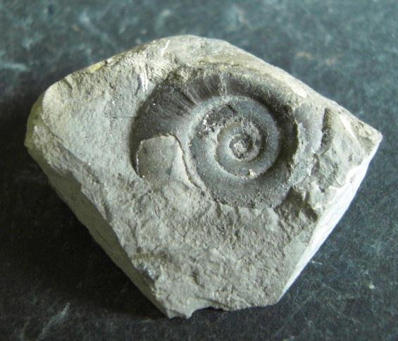
Ammonites are recognised by their coiled form; preserved chamber divisions, ribs or a spiral cross-section can help distinguish them from an ordinary rounded stone. The existing ammonite photograph shows a specimen in a pale rock, without a reliable species or source-bed identification. Belemnites usually appear as solid, tapering, bullet-like guards, sometimes with only a broken cross-section visible. Do not expect every worn fragment to retain enough features for a precise name.
Echinoids may preserve an oval or rounded test and traces of the characteristic five-part pattern of pore rows. Coral-bearing stones can show repeated corallites, each with an organised internal pattern, while bivalves may survive as valves, curved shell sections or moulds. Check the structure across more than one exposed surface where possible: a single smooth curve or pale patch is not by itself diagnostic. These are recognition clues for the broad groups reported here, rather than a list of species guaranteed on a visit.
The original observations describe rocks of Carboniferous, Jurassic and Cretaceous age among the beach material. A fossil and its surrounding matrix can sometimes indicate a broad age or rock type, even when its original bed is unknown. Keep the geological age of the specimen separate from the age of the modern beach on which it was found. A Jurassic-looking fossil in a loose stone does not establish a Jurassic exposure beneath your feet, nor does it prove that the stone travelled from one particular Yorkshire locality.
The younger foreshore deposits are a different kind of fossil site. Historical Chapel Point research records oak trees rooted in basal peat, wood of Salix and Taxus in an upper peat, and the bivalve Scrobicularia plana in channel-filling clay. One sampled shell assemblage was preserved in growth position with shells then identified as Cardium edule and Macoma balthica. These names belong to a historical scientific record; a loose modern-looking shell on the beach cannot be assigned to those deposits by appearance alone.
If peat, clay, roots or embedded shells are uncovered, their relationships are the important evidence. A rooted tree surface or shells still positioned in a channel fill reveal an environment in a way that an isolated fragment cannot. Photograph the feature in place, include a scale without disturbing it, and record its position and date. Leave the protected deposits intact rather than digging, pulling out wood or enlarging an exposure. The detailed geology below explains the documented horizons without implying that they are visible today.
For any loose mineralised specimen that you have permission to take, photograph it before moving it and label it with the precise finding place, date and “loose beach find; original bed unknown”. Retain information about the surrounding stone and whether it was found among natural beach sediment or close to a managed beach-work area, without treating that setting as proof of origin. Small wrapped specimens are easier to keep intact than an unlabelled assortment of worn fragments. Do not split sea-defence rock or large boulders of uncertain origin and ownership.
Discoveries and milestones
Significant discoveries, geological research and conservation milestones at Chapel Point.
1953 – Upper-peat wood collected for radiocarbon dating
Wood from the upper peat was collected by Smith and later dated as sample Q-81. Godwin and Willis’s subsequent Chapel Point account records its result as 2455 ± 110 radiocarbon years BP. The collection supplied an early age constraint on the peat, rather than a date for the older fossils in loose beach stones.
October 1961 – Peat contact and deep-channel shells sampled
D. M. Churchill collected peat at the upper-peat/“Phragmites clay” contact for Q-686, and Scrobicularia plana from a channel cut down into leached till for Q-688. Their different positions connected the dating programme to the development of the peat and the later marine channel fill.
September 1962 – Growth-position shell assemblage sampled
Churchill collected Q-687 from a channel truncating the upper peat. Scrobicularia plana occurred in growth position with shells identified historically as Cardium edule and Macoma balthica, providing a sample tied to the environment and contact of the shell-bearing clay.
1964 – Chapel Point radiocarbon series published
H. Godwin and E. H. Willis published the local peat-and-clay sequence and the new radiocarbon measurements. They combined the earlier stratigraphic work of H. H. Swinnerton with Churchill’s samples to examine the relationship between peat formation, erosional channels and marine inundation. The reported ages are historical uncalibrated determinations.
18 July 2002 – Chapel Point–Wolla Bank notified as an SSSI
The approximately 1.5 km foreshore was notified for its nationally important Holocene deposits. Interbedded peats, saltmarsh deposits and shelly clays, studied through plant and animal remains and radiocarbon dating, preserve evidence used to reconstruct coastal environments and sea-level change.
2011 – Monitoring documents the defended point and changing beach
The Environment Agency’s coastal morphology report documented Chapel Point with dated photographs and mapped nearby nourishment reaches. It described the narrow, wave-exposed beach beside the defended promontory and the difficulty of retaining sand there, providing a local record of the modern processes that change the visibility of older foreshore deposits.
Geology
Chapel Point brings together geological records of very different ages. The older ammonites, belemnites and other marine fossils occur in transported stones on a modern sandy beach. The coherent succession beneath parts of the foreshore is much younger: glacial till overlain by Holocene peats and tidal sediments. The Carboniferous, Jurassic and Cretaceous stones therefore belong to a mixed beach assemblage, rather than to a local stack of bedrock formations.
The historical Chapel Point section begins with a wooded land surface developed on till. Oak trees were recorded in their growth position within the basal peat. Erosion interrupted this surface before saltmarsh sediment accumulated, passing upwards into brackish-water clay and then another thin peat. These changes record a shifting boundary between land, wetland and tidal water, rather than a simple, uninterrupted rise of the sea through identical environments.
The upper peat contained willow and yew wood, recorded scientifically as Salix and Taxus, and its surface preserved evidence of early Iron Age salt-making. Later channels cut through the peat and, locally, down into the underlying till. More marine shell-bearing clay occupied these channels. Shells preserved in growth position, together with plant remains and radiocarbon samples tied to particular contacts, made the deposits valuable for reconstructing former coastal conditions.
Godwin and Willis published the Chapel Point radiocarbon series in 1964. Its sample measurements remain useful historical evidence, but they are uncalibrated radiocarbon years BP and must not be read as precise calendar dates. The sample heights are levels relative to Ordnance Datum, not bed thicknesses. Modern calibration, the behaviour of marine shell carbon and the original tidal assumptions would all need specialist assessment before using the results for a precise calendar or sea-level reconstruction.
Modern waves continually rearrange the beach cover. Natural England describes the older foreshore deposits as periodically exposed and buried, so the documented succession is not a permanently visible section. Beach nourishment adds another source of change: offshore-dredged sand is supplied to the wider managed Lincolnshire frontage, with local historical works mapped near Chapel Point. New sand can obscure stones and organic deposits, while later erosion may reveal them again. A dated works programme does not establish a closure or exposed bed on the day of a visit.
The coast also redistributes loose material, and the Environment Agency records an overall southerly tendency in sediment movement. Glacial deposits, subsequent coastal transport and nourishment can all complicate the provenance of a beach stone. A single Holderness origin cannot be assumed for every stone: some material may have passed through glacial deposits, but neither a fossil’s age nor its presence at Chapel Point proves the complete route. The defended promontory also influences local beach shape; its narrow, wave-exposed margin deserves particular care.

Detailed geology and bed-by-bed succession
Detailed geology of Chapel Point’s historical Holocene succession, contacts and radiocarbon samples.
Scope and terminology. The succession below describes the historical Chapel Point foreshore series used by Godwin and Willis in 1964, together with the protected peat-and-clay record between Chapel Point and Wolla Bank. It is a record of superficial deposits, not an exposed Carboniferous–Cretaceous bedrock section. The account proceeds from the oldest substrate upwards. “Chalky Boulder Clay”, “Triglochin Clay”, “Phragmites clay” and “Scrobicularia Clays” are historical descriptive names here; no modern formal Group, Formation or Member assignment is established by these sources.
Glacial till substrate, historically “Chalky Boulder Clay”. Till underlies the organic and tidal sequence. The historical section places the basal peat directly on it, with oak trees still in their growth position. A later erosional channel penetrated to leached till, and the shell sample Q-688 came from the channel bottom at −9 ft OD. This is a sample elevation relative to Ordnance Datum, not a thickness for the till or the overlying deposits. The evidence does not identify a modern formal till unit or a fauna specific to this substrate.
Basal peat and rooted oak surface. The lower peat represents a terrestrial wooded surface developed above the till. Oak trees preserved in place provide stronger evidence of the former land surface than isolated wood washed onto the modern beach. The 1964 account supplies neither a measured thickness nor a radiocarbon determination for this basal peat. It must not be assigned the dates obtained from the separate upper peat.
Erosion at the basal peat–saltmarsh-clay contact. An erosion surface separates the basal peat from the overlying “Triglochin Clay”. Part of the earlier record is consequently missing, so this contact should not be represented as uninterrupted accumulation from woodland into saltmarsh. The source gives no duration for the break and no measured relief for this surface.
“Triglochin Clay”: the saltmarsh interval. This historical unit overlies the erosion surface and was interpreted as a saltmarsh deposit. In the discussion of sample Q-686, the authors cite Suaeda maritima and Salicornia sp. as evidence for saltmarsh conditions close to high spring-tide level. Those plant occurrences support the environmental interpretation; Q-686 itself was collected from the base of the upper peat, not from this clay. No local thickness is supplied.
“Phragmites clay”: brackish-water sediment below the upper peat. The saltmarsh clay passes upwards through this brackish-water interval into a thin upper peat. The historical name is retained to identify the published horizon, without implying a verified formal Member or a quantified abundance of reed remains. The contact with the overlying peat was sampled at 0 ft OD for Q-686. The paper does not provide a separate thickness for the clay.
Upper peat, its wood and salt-making surface. The thin upper peat contained wood identified as Salix and Taxus. Its surface lay close to mean sea level in the historical study and carried remains interpreted as salt-making of early Iron Age, or Hallstatt, type. This is the upper of the two principal peat horizons described here. The source does not provide a numerical thickness, and its reference to mean sea level should not be treated as a present-day survey.
Upper-peat radiocarbon samples Q-686 and Q-81. D. M. Churchill collected saltmarsh peat for Q-686 in October 1961 from the base of the upper peat, where it met the underlying “Phragmites clay” at 0 ft OD. The published result was 3340 ± 110 radiocarbon years BP. The same account cites an earlier result, Q-81, of 2455 ± 110 BP from upper-peat wood collected by Smith in 1953. Q-81 was not a new 1964 collection, and the account does not place it at the exact Q-686 contact. The authors interpreted the peat’s development within their Bronze Age chronology and rejected a Romano-British age; these are historical interpretations, not newly calibrated calendar dates.
Erosional channels through the upper peat. A later erosional episode cut channels through the upper peat and the beds beneath it. The documented cuts vary in depth: Q-687 came from a narrow channel truncating the upper peat, whereas the deeper Q-688 channel reached leached till. The channels therefore interrupt the older succession rather than forming an additional horizontal bed of uniform thickness. Their different sample levels must not be subtracted to invent a measured thickness for a single clay layer.
“Scrobicularia Clays” and Q-687. The clay succeeding the channel-cutting episode was interpreted as more marine than the earlier “Triglochin Clay”. Q-687 comprised Scrobicularia plana shells collected in September 1962 from a narrow channel that truncated the upper peat at +1.3 ft OD. The shells were in growth position with specimens historically identified as Cardium edule and Macoma balthica. The published age was 2630 ± 110 radiocarbon years BP. The authors suggested that this assemblage had lived within the contemporary neap-tide range and could date the marine incursion responsible for the clay. The historical species names are retained rather than silently updated.
Deep-channel shell sample Q-688. Churchill collected Scrobicularia plana in October 1961 from the bottom of a channel cut into leached “Chalky Boulder Clay”, at −9 ft OD. This sample also returned 2630 ± 110 radiocarbon years BP. The paper interpreted the channel base as possibly approaching the former low spring-tide erosion limit and, on that assumption, inferred a sea level about 7 ft above its then-modern comparison. This was an explicitly conditional historical interpretation. It is not a modern calibrated sea-level reconstruction or a prediction for today’s shoreline.
What the measurements establish, and their limits. The matching Q-687 and Q-688 determinations led the authors to infer little elapsed time between channel erosion and deposition of the shell-bearing clay. The saltmarsh discussion also compared inferred former high spring-tide conditions with a then-contemporary level said to be about 16 ft higher. These comparisons depend on historical ecological and tidal assumptions. All four quoted ages are uncalibrated radiocarbon results, with BP conventionally measured before AD 1950; the paper’s simple BC equivalents are not modern calibrated ages. Calendar conversion and marine reservoir effects require specialist treatment. Neither the dates nor the OD sample levels date the loose older fossils or show that a particular horizon is exposed now.
Modern mobile beach cover. Waves alternately uncover and bury the foreshore peats, clays and shelly deposits. Natural England identifies this changing exposure as part of the site’s management context and stresses the importance of retaining the sediment dynamics that reveal the geological features. There is no complete current measured section in the sources used here, and no reason to expect every horizon to be visible continuously between Chapel Point and Wolla Bank. The sand cover has a variable, unmeasured thickness.
Older fossil-bearing stones: a separate transported assemblage. The original Chapel Point observations report ammonites, belemnites, echinoids, corals and bivalves among loose Carboniferous, Jurassic and Cretaceous rocks. Their occurrence does not create an in-situ succession of those ages. A fossil and matrix may support a broad age identification while leaving the original bed and route of transport unknown. Glacial reworking and coastwise redistribution are possible contributors, but a loose stone is not automatically a proven glacial erratic. The documented net southerly drift of beach material does not establish a Holderness origin for every specimen.
Beach nourishment: an independent modern input. The 2011 coastal morphology report maps nourishment reaches near Chapel Point and describes the defended promontory, where sand was difficult to retain. The Environment Agency’s announcement of 8 June 2026 describes offshore dredging for the wider Saltfleet–Gibraltar Point beach-management scheme, with replenishment undertaken annually since 1994. This establishes an artificial input to the managed coast, not the origin of any particular fossil-bearing stone. The 2026 announcement scheduled work from 9 June for about four to five weeks; it does not establish a present closure, a present exposure or identical treatment of every reach.
References. Godwin, H. and Willis, E. H. (1964), Cambridge University Natural Radiocarbon Measurements VI, Radiocarbon 6, Chapel Point series on pp. 129–130; DOI: 10.1017/S0033822200010602. Natural England, Chapel Point–Wolla Bank SSSI citation, notified 18 July 2002, and Views About Management. Environment Agency (2011), Coastal Morphology Report: Lincolnshire (Mablethorpe to Skegness), RP023/L/2011. Environment Agency (8 June 2026), Vital annual beach work reduces flood risk on Lincolnshire coast.
Safety
Check tide times, the weather and sea conditions before setting out. Keep a safe return route and allow time to leave the lower beach well before rising water reaches it. Runnels can hold or channel water, and the usable strip beside the hard defences may narrow sharply. Do not assume that the absence of cliffs prevents tidal cut-off.
The concrete point, steps and rock armour are exposed to waves and can be slippery or uneven. Keep children away from the edge, do not climb the armour, and avoid searching where waves are breaking against the structure. Choose the open sandy beach for a family visit and leave a geological search for another day if conditions are unsuitable.
Exposed clay, peat and wet sand can be soft and slippery. Do not wade across a runnel or cross uncertain ground to reach a fossil or darker patch. Keep clear of any machinery, pipes, barriers or signed beach-work area, and use the route available on the day rather than assuming an old photograph shows current access.
Equipment
Take footwear with good grip, weatherproof clothing, a hand lens, a camera, a small scale and a notebook or offline map. Carry the tide information with you and protect your phone from water. For small loose specimens that you have permission to collect, use wrapping and a rigid box, with a separate label for each finding place.
A hammer is unnecessary for inspecting exposed beach stones and is inappropriate for investigating the protected peat and clay. Do not bring tools with the intention of splitting sea-defence blocks or extracting embedded material. Recording visible surfaces usually preserves more useful information than breaking a weather-worn stone at the water’s edge.
Cleaning And Treating
Photograph a lawfully collected mineralised find before cleaning, and retain its label and useful matrix. Begin with a soft dry brush under good light. A sound, compact stone may tolerate a cautious rinse, but crumbly matrix, fragile shell and fine surface detail can be damaged by water or scrubbing. Test a small area first and let stable damp specimens dry slowly at room temperature.
Calcitic shells, corals and limestone are vulnerable to acid. Avoid household acids, bleach, aggressive wire brushing and routine varnish. Do not force hard matrix away if the fossil breaks with it; an ammonite or echinoid embedded in a hard stone may need specialist mechanical preparation. Leave a potentially important specimen unprepared until it has been assessed.
Waterlogged wood and peat are different from robust mineralised fossils and can deteriorate after removal and drying. Leave exposed organic remains and in-situ shell assemblages in place, photograph them, and seek advice about significant features. The methods above are for appropriate loose mineralised material, not a treatment recipe for excavated foreshore organics.
Identify Your Finds
Need help identifying a fossil? Share clear photos, where you found it and its size with the community.
Further Reading
Godwin and Willis (1964): Chapel Point radiocarbon samples and historical succession, pages 129–130
Natural England: Chapel Point–Wolla Bank SSSI citation (use the directions above, not its erroneous printed grid reference)
Natural England: management of the intermittently exposed foreshore deposits
Environment Agency (2011): coastal morphology, Chapel Point photographs and beach nourishment
Visit Lincolnshire: Chapel Point to Wolla Bank walk and Observatory starting point
Access Rights
The Chapel Point to Wolla Bank SSSI protects an approximately 1.5 km foreshore section northwards from Chapel Point for its Holocene deposits and environmental record. The protected intertidal area, the concrete promontory and the landward car park are different features; consult the official site information when planning work on the shore.
Public beach access does not itself give permission to dig, hammer or remove fossils and sediment. Before taking material, establish the landowner’s or responsible manager’s current requirements and any consent needed for the particular place and activity. Leave peat, roots, wood and embedded shells undisturbed, respect wildlife and sea defences, and follow current notices and barriers.
It is important to follow our ‘Code of Conduct’ when collecting fossils or visiting any site. Please also read our ‘Terms and Conditions‘
Links
♦ Fossil Discussions
♦ Fossil Articles
♦ Buy Fossils, Tools and Equipment
♦ Buy Crystals, Meteorites, and Artefacts
♦ Join Fossil Hunts
♦ UK Fossils Network


