

Overview
Directions
- Craighead Quarry lies near Low Craighead Farm, north-east of Girvan in South Ayrshire. Follow the B741 along the north side of the Girvan valley and take the minor road towards Drummuck at Low Craighead. Arrange access and ask where you may park before setting out.
- Published excursion guides describe the old quarry access track on the left, about 200 m beyond the farm, near NS 235 014. The approach passes the ruined quarry works; a path into the quarry branches from the track. Confirm that this route remains usable rather than relying on old descriptions of paths, gates or parking spaces.
- Keep farm entrances and tracks clear. Historical informal parking advice is not a current parking agreement. Do not attempt a direct descent from the roadside: steep, overgrown quarry sides make this dangerous.
- The main quarry is centred approximately on NS 234 014, with smaller workings to the south-west. The original guide gives 55.27472°N, 4.78109°W as a locality reference, not a verified parking waypoint. Carry a map and turn back if the agreed approach is obstructed or unsafe.
Location photographs
Swipe to browse · Select a photograph to enlarge


Fossil Hunting
Craighead is valuable because different rocks preserve different parts of an Ordovician marine community. Brachiopods, trilobites, crinoids, corals and bryozoans are recorded from the quarry complex, together with bivalves, gastropods, ostracods, cystoids, cephalopods and microscopic conodonts. These are documented occurrences across several facies, not a list of equally common finds or material available for collection today. Begin with observation and photography; any removal must follow the permissions described below.
In the limestone, inspect naturally weathered surfaces for ribbed shell sections, rounded or disc-shaped crinoid ossicles and colonial or branching textures. Much of the material consists of broken skeletal debris incorporated into the rock rather than complete animals. Crinoid-rich limestone, rolled coral material and locally slumped beds reflect movement of sediment on and around the carbonate platform. A hand lens and photographs with a scale are more useful for recognising this fabric than expecting every dark patch to be a complete fossil.
The massive pinkish or greenish limestone breccias include material rich in Girvanella, a calcareous microbial or algal form described in the geological literature. These rocks developed over volcanic highs, while conglomerates and sandy carbonate accumulated in neighbouring hollows. Their texture may look quite different from the more evenly bedded shell-rich limestone. Keep the rock type and any securely observed horizon with your field notes; detached scree can mix material from several levels.
The Sericoidea Mudstone Member and the higher Kiln Mudstone Member contain distinct shelly assemblages. Published records include brachiopods and trilobites, with graptolites in the Sericoidea interval. Some Kiln Mudstone fossils occur in calcareous concretions that have become decalcified, leaving delicate moulds. Look carefully at naturally exposed surfaces without excavating the mudstone, undermining slopes or disturbing the old kiln and retaining wall. Historical accounts describe damage at that wall, so it is not a place to dig for specimens.
Graptolites from the Sericoidea mudstone help correlate the rocks with the lower Dicranograptus clingani Biozone. They require careful examination: a dark streak alone is not an identification. Likewise, the approximately 25 ostracod species reported in the 2010 study are tiny crustaceans investigated by specialists, rather than conspicuous hand-sized fossils. The published assemblages record both partly restricted and deeper platform settings.
Important historical descriptions include the trilobites Encrinuroides lapworthi from the Sericoidea mudstone and Bumastoides fornax from the Kiln mudstone, as named by Tripp in 1980. These examples explain the quarry’s scientific value; they are not identifications of the photographs below.
If limited collecting is expressly permitted, stay within the agreed places and methods, retain useful locality information and avoid taking repeated examples. Preserve a fossil and its counterpart together where they are already loose and collection is allowed. Photograph significant material in context and seek specialist advice before moving it. The quarry’s value lies in the relationship between fossils and their beds, which indiscriminate splitting or extraction can destroy.

Fossil photographs
Swipe to browse · Select a photograph to enlarge


Discoveries and milestones
Significant discoveries, geological research and conservation milestones at Craighead Quarry, in chronological order.
1851 – Early account of the fossiliferous limestone
Adam Sedgwick recorded fossils in the earthy limestone at Craighead and its association with a large igneous mass. Roderick Murchison also discussed the Craighead inlier that year, establishing an early published record of its geological interest.
1882 – First influential limestone correlation
Charles Lapworth correlated the Craighead Limestone with the Stinchar Limestone. Although later overturned, this interpretation shaped the debate over the age and position of the quarry succession.
1899 – Geological Survey description
Ben Peach and John Horne’s major survey memoir described the Craighead succession and its fossils. The locality had become an important focus for collecting and comparison within the Girvan district.
1930 – The old correlation challenged
E. O. Ulrich questioned the correlation with the Stinchar Limestone, helping reopen the problem of the age of the Craighead rocks.
1935 – Fossils support a younger age
F. R. C. Reed argued for a younger age and documented a diverse fauna, while Archibald Lamont retained the earlier correlation. Reed’s lists combined material from limestone and mudstone, a distinction later studies would resolve more carefully.
1946 – The kiln-area section described
F. W. Anderson and John Pringle published a Craighead section under the historical name “Balclatchie Beds”. The mudstones were subsequently recognised as the Kiln Mudstone within the Craighead Limestone succession.
1954 – Kiln Mudstone trilobites revised
R. P. Tripp studied the trilobites of the Craighead mudstones and used the name Kiln Mudstones. This work helped establish the character of a major fossil-bearing interval within the quarry succession.
1961 – Craighead crinoids described
W. H. C. Ramsbottom’s monograph treated the quarry’s crinoids, including Diabolocrinus craigheadensis and Diabolocrinus globularis. This publication established an important reference for the more complete crinoid remains from Craighead.
1962 – Definitive quarry mapping and brachiopod study
Alwyn Williams published detailed quarry maps, sections and brachiopod descriptions. His correlation of the limestone with upper Ardwell rocks showed its younger age and strengthened the evidence for progressive northwards flooding across an irregular volcanic foundation.
1978 – The Ardwell correlation refined
J. Keith Ingham placed Craighead slightly lower within the upper Ardwell succession than Williams had proposed. This refinement became the accepted correlation in subsequent geological synthesis.
July 1979 – Refuse-disposal proposal opposed
The Nature Conservancy Council received a proposal to use Craighead Quarry for refuse disposal. Geologists raised objections because filling the quarry threatened internationally important exposures and fossil-bearing strata.
1980 – New trilobites and a graptolite age constraint
R. P. Tripp described Encrinuroides lapworthi from the Sericoidea Mudstone and Bumastoides fornax from the Kiln Mudstone. Graptolites from the lower mudstone indicated the lower Dicranograptus clingani Biozone, sharpening the age correlation.
1981 – A stalked echinoderm described
Regnéll and Paul described Pleurocystites mitratus, a rhombiferan recorded from the Craighead Limestone Formation. This stalked echinoderm is distinct from the crinoids also known from the quarry.
February 1983 – Conservation case prepared for inquiry
The Nature Conservancy Council reported preparations for a public inquiry scheduled for March, after earlier postponements. It and the Institute of Geological Sciences concluded that the quarry’s geological interest could not be retained if tipping went ahead.
23 February 1984 – Designation date in the official SSSI record
The current Craighead Quarry SSSI record gives this designation date. Protection predates it: a conservation account published in 1980 already described the quarry as having held SSSI status for more than 25 years.
1986–1995 – Isolated crinoid stems studied
Stephen Donovan’s three-part monograph documented the locality’s diverse isolated crinoid columnals. More than 20 columnal morphotaxa were later summarised from Craighead; these names for isolated parts do not necessarily represent the same number of biological species.
1990 – Conodonts refine the limestone age
Stig Bergström studied conodonts from limestone immediately beneath the Kiln Mudstone. The fauna probably indicated the Amorphognathus superbus Zone, although the Amorphognathus tvaerensis Zone remained a possible alternative.
1992 – Detailed excursion synthesis
J. Keith Ingham brought together the quarry’s irregular volcanic foundation, contrasting limestone facies, two mudstone intervals and adjacent Plantinhead succession. His account also recorded that collecting had dangerously undercut the old kiln retaining wall.
2000 – Geological conservation and ostracod research
A major geological conservation synthesis emphasised the quarry’s exceptional transgressive contact and importance as a source of fossil type material. Work by Williams and Floyd on its ostracods also contributed to understanding links between Laurentian and Baltic faunas.
2010 – Carbonate environments distinguished by ostracods
Mohibullah and colleagues documented about 25 ostracod species and distinguished shallow lagoonal from deeper platform-margin assemblages. They described Duoarcus levigatus and explored the fauna’s North American affinities and the earlier Baltic origins of several genera.
March 2014 – Ostracod monograph and new species
Mohibullah, Williams and Zalasiewicz’s monograph distinguished limestone and mudstone ostracod records and described Leperditella girvanensis using Craighead material. Although the volume is dated 2013, the issuing Society records its publication in March 2014. The work placed the quarry’s sampled horizons within a detailed regional study; its regional species total is not a count of Craighead finds.
2014 – Brachiopod taxonomy and assemblages revisited
Yves Candela and David Harper’s revision of historical Girvan brachiopods reconsidered the Craighead material and its biofacies. Distinguishing the limestone and mudstone collections helped avoid treating the quarry’s different fossil assemblages as one uniform fauna.
2020 – Crinoid stems linked with fossil cups
Stephen Donovan and Neil Clark linked isolated Craighead crinoid stem remains with Diabolocrinus by comparing the stem-attachment surfaces of two incomplete fossil cups. Their revision connected names based on stems with those based on more complete animals, while leaving the studied specimens at open species-level identification. It did not reassign every occurrence of Oanducystis elsewhere or identify every Craighead stem to a named species.
Geology
The quarry exposes the Craighead Limestone Formation, within the Ardwell Subgroup of the Ardmillan Group. It is a Late Ordovician carbonate succession, assigned to the early Katian by the ostracod studies’ graptolite and conodont correlations and traditionally described in regional Caradoc terminology. Here the basal sedimentary rocks lie unconformably on irregular volcanic basement, an important record of marine flooding across an older landscape. Historical comparisons with other Girvan formations have since been revised.
The volcanic foundation is mapped in the BGS Ayr account as the Craighead Volcanic Formation. Classic descriptions associated the pillow lavas with the Ballantrae Complex, but the BGS Lexicon leaves their age uncertain: an Arenig or Balcreuchan affinity is possible, while a younger Caradoc age is also possible if the associated chert and lava are contemporaneous. The underlying rocks should therefore not be labelled uniformly as definitely early Ordovician.
This uneven foundation controlled the first deposits. Conglomerate with volcanic and other clasts and green calcareous sandstone accumulated beside volcanic highs, passing into rubbly and pebbly limestone. Over higher ground, massive Girvanella-rich carbonate and breccia developed. Bedded crinoidal and other bioclastic limestones, locally slumped, record neighbouring environments and movement of skeletal debris. These facies intergrade laterally; they cannot be read as an identical stack of beds in every quarry face.
Two named mudstone intercalations interrupt the carbonate succession: the lower Sericoidea Mudstone Member and the higher Kiln Mudstone Member. The lower member records a deeper-water interval; both contain shelly assemblages distinct from the limestones. The Kiln mudstone interdigitates with higher massive limestone. Folding, faulting and rapid facies changes complicate correlation, so the BGS formation-scale estimate of up to 90 m is not a measured thickness of any one exposed face.
The overlying regional succession includes the Ardwell Farm Formation and its Plantinhead Member, historically called the Plantinhead Flags or Formation. Fine graded sandstone and siltstone occur in the adjacent stream to the east, but the quarry’s upper relationship is faulted or not seen in the BGS Lexicon account. Plantinhead forms an adjacent part of the deeper-water succession, but a continuous cap is not exposed above every limestone face.
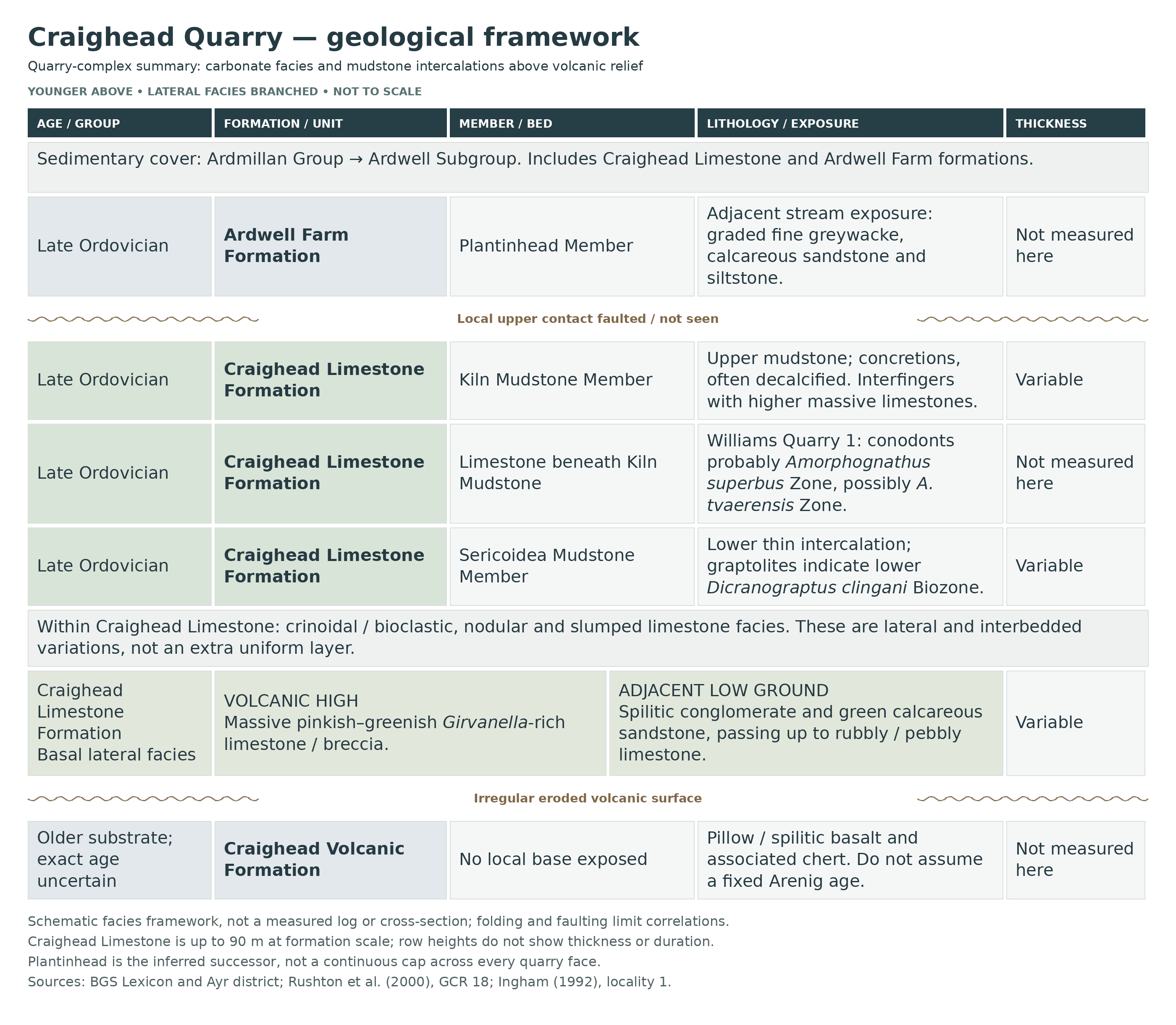
Detailed geology and bed-by-bed succession
Detailed geology of Craighead Quarry, its volcanic foundation, limestone facies and mudstone members.
Craighead Quarry exposes a varied Upper Ordovician carbonate succession deposited across an uneven volcanic landscape. Limestone, conglomerate and mudstone change laterally over short distances, and later folding and faulting complicate their relationships. The account below distinguishes actual formations and members from descriptive facies and fossil-bearing horizons; it is not a measured bed-by-bed log.
Craighead Volcanic Formation
Volcanic foundation and erosional surface. Basaltic pillow lavas, altered to spilite, and associated cherts form the foundation beneath the sedimentary rocks. The local base of the volcanic succession is not exposed. Erosion produced pronounced highs and hollows before limestone deposition; a volcanic high survives within the main quarry, where its outcrop is truncated by a fault. Conglomeratic and carbonate deposits rest unconformably on this irregular surface.
Age of the foundation. Older accounts identify these rocks with the Arenig Ballantrae ophiolite. More recent mapping names them the Craighead Volcanic Formation and retains an important age qualification: if the associated cherts are coeval with the lavas, the volcanic rocks could be substantially younger, of late Llanvirn to early Caradoc age in traditional terminology. An unequivocal Arenig age should therefore not be assigned to the quarry basement.
ARDMILLAN GROUP
The sedimentary cover belongs to the Ardmillan Group. At Craighead it records the advance of the sea across the volcanic foundation on the Laurentian side of the Iapetus Ocean. Its local basal relationship differs from that in the main Girvan succession south of the valley: the quarry limestone rests on volcanic rocks rather than an exposed Barr Group or Benan Conglomerate succession.
ARDWELL SUBGROUP
The oldest sedimentary subgroup represented at Craighead is the Ardwell Subgroup, which locally begins at the base of the Craighead Limestone Formation. Only a condensed part of the regional succession is represented in this inlier. The subgroup’s much larger regional thickness is not a measurement of Craighead Quarry.
Craighead Limestone Formation
Craighead is the type locality and principal exposure of this formation. Massive, bedded and nodular limestones occur with basal conglomerates, calcareous sandstones and impersistent mudstones. The published thickness estimate is up to about 90 m for the formation, not a continuous thickness visible in one quarry face. The rocks are traditionally described as mid-Caradoc; the graptolite and conodont correlations used by Mohibullah and colleagues place the carbonate succession in the early Katian, within the Upper Ordovician. Their lower Dicranograptus clingani assignment includes the caudatus Subzone, and the 2023 regional synthesis is consistent with this earliest Katian placement. Faulting near the Kerse Loch Fault zone and strong lateral facies changes prevent a simple correlation of every face.
Basal conglomerate and green calcareous sandstone. Lower ground beside the volcanic high received conglomerates containing fragments of spilite, serpentinite and jasper. Green sandstones vary in their carbonate content. These deposits pass both laterally and upwards into rubbly and locally pebbly limestone, recording the uneven distribution of coarse sediment and carbonate around the drowned relief. They are descriptive basal facies, not a formally numbered bed.
Girvanella-rich limestone and breccia on volcanic highs. Carbonate deposited over the higher volcanic surface includes massive, pinkish to greenish, brecciated limestone containing abundant Girvanella, a calcareous microbial form traditionally described as an alga. These shallow-water deposits developed alongside the conglomerates in nearby hollows rather than forming one uniform layer above them. Their brecciated and conglomeratic character reflects energetic conditions and reworking.
Bedded crinoidal and other bioclastic limestone. Elsewhere the limestones contain abundant skeletal debris, including crinoid fragments and locally rolled corals. Some are nodular; others contain appreciable sand or mud. Slumped limestone and broken fossil material record movement on local slopes, so a fossil-rich rock need not preserve organisms in their original living positions. These limestone types interdigitate with each other and with mudstone. They record a varied carbonate setting rather than a single unchanging reef environment.
Environmental variation. Later study of carbonate lithofacies and ostracods recognised settings ranging from partly restricted, shallow platform conditions to open platform margins, deeper shelf and slope. These environmental categories are not successive formal members. The evidence indicates a varied carbonate platform, and its changing depth and sediment supply help explain the differences between fossil assemblages in limestone and mudstone.
Research sampling horizons within the limestone formation. The ostracod monograph distinguishes four sampling sites in the quarry complex. Their identifiers describe separate exposures, not successive beds or additional formal members; they are records of scientific sampling rather than collecting directions.
Southern quarry limestone: Locality 6a (A). One fossiliferous horizon in irregularly bedded limestone yielded numerous calcitic ostracods that could be cracked out of the rock. This material includes type specimens of Oepikella tunnicliffi and Leperditella girvanensis. No measured thickness is given for this horizon, and it is not assigned a separate member rank.
Middle quarry breccia–calcarenite: Locality 6b (B). Sampling of this carbonate facies yielded only one indeterminate ostracod valve. The contrast with the richer limestone and mudstone samples demonstrates that ostracods are not equally abundant or recoverable in every carbonate facies.
Northern limestone–mudstone interbeds: Locality 6c (C). Thin limestone beds alternate with mudstone. Fifteen mudstone samples spanning a 10 m interval yielded numerous calcitic ostracods, including the holotype of Duoarcus levigatus. The 10 m is the sampled interval, distinct from the formation-scale estimate of up to 90 m. The source does not assign these interbeds to either the Sericoidea or Kiln Mudstone Member.
Satellite quarry limestone: Locality 7 (Quarry 2). Limestone from this small quarry yielded tens of calcitic crack-out ostracods. It provides another documented fossiliferous limestone horizon, but the sampling identifier establishes neither a new formal bed nor its precise vertical position relative to the three main-quarry sites.
Sericoidea Mudstone Member
The lower of the two named mudstone intercalations is a relatively thin, impersistent interval between limestones. It records a deeper-water interruption in carbonate deposition and contains brachiopods, trilobites and graptolites. Its name refers to the small brachiopod Sericoidea. Ostracods studied from this member in the later monograph are preserved as decalcified internal moulds. Published quarry accounts disagree over which side of the ramp carries the exposure.
Lower Dicranograptus clingani Biozone. Graptolites from this member provide an important age tie to the lower part of the Dicranograptus clingani Biozone. This is a fossil-based correlation, not an additional rock bed. Together with the shelly faunas, it shows why Craighead Limestone is younger than the Stinchar Limestone with which it was once correlated. The trilobite Encrinuroides lapworthi was described from this mudstone in 1980.
Limestone immediately below the Kiln Mudstone. A conodont sample from the topmost limestone below the Kiln Mudstone in Williams’ Quarry 1, one of the smaller quarry sections, adds a second age constraint. It was assigned probably to the Amorphognathus superbus Zone, although an origin within the Amorphognathus tvaerensis Zone could not be excluded. The uncertainty should be retained; the sample does not establish a precisely dated, quarry-wide marker bed.
Kiln Mudstone Member
The upper mudstone interval is more substantial and lies within the higher part of the limestone formation. Sections in the small quarries to the south-west demonstrate that it interdigitates with the higher massive limestones. It is historically described near the ruined kiln in the main quarry, but that position must not be treated as an invitation to work beneath unstable masonry.
Small calcareous concretions, commonly decalcified, have yielded a rich trilobite and brachiopod fauna. Fossils may therefore occur as delicate moulds rather than intact shells; the later ostracod monograph specifically records decalcified internal ostracod moulds from this member. The fauna differs from that of the lower mudstone and from the limestone assemblages; Bumastoides fornax was described from this member in 1980. Early descriptions used “Balclatchie Beds” for this material, but that historical correlation does not make the modern Craighead Limestone Formation part of the Balclatchie Formation.
Ardwell Farm Formation
The succeeding Ardwell Farm Formation is relevant to the adjacent succession east of the quarry. Its relationship to the Craighead Limestone is locally faulted, and the current formal definition records an unseen, faulted upper boundary to the limestone formation. A continuous contact is therefore not exposed across the quarry faces.
Plantinhead Member
The historical “Plantinhead Flags” or “Plantinhead Flags Formation” is now treated as the Plantinhead Member of the Ardwell Farm Formation. Fine graded greywackes, calcareous sandstones and siltstones are described in the stream section immediately east of the quarry; siltstone is an important component of this member. Graptolites support correlation within the Dicranograptus clingani Biozone. The change from carbonate to these finer siliciclastic deposits has been interpreted as deepening and foundering of the area, possibly linked to movement on basement faults. These nearby exposures complete the geological context without implying that the member is accessible or clearly exposed within the quarry today.
References
British Geological Survey. Craighead Limestone Formation, BGS Lexicon.
British Geological Survey. Ardwell Subgroup, BGS Lexicon.
British Geological Survey. Ayr district sheet description, Ordovician succession.
British Geological Survey. Ordovician sedimentary succession, Girvan–Ballantrae district.
Safety
This is an old quarry with steep sides, loose rock, rough scree and overgrown ground. Faces and slopes can shed material without warning. Keep well away from the foot and edge of steep faces, do not climb scree or enter concealed workings, and avoid standing beneath other visitors.
The floor and approach have historically been boggy, especially after rain. Wear sturdy footwear with good grip and assess conditions on arrival; vegetation can conceal holes, loose stones and changes in slope. Do not descend into the quarry directly from the road.
Keep clear of the ruined kiln and retaining walls. Published accounts warn that collecting had undercut an old wall; do not dig beneath masonry or test its stability. The photographs and 2008 visit date do not establish the safety or accessibility of the site now.
Equipment
For an observational visit, take a hand lens, camera, scale, notebook and map, with sturdy boots and suitable weather protection. A charged phone is sensible, but do not assume a signal within the quarry.
If collecting has been specifically agreed, take only the equipment allowed and soft wrapping for fragile loose specimens. A hammer or pick is not a default requirement here: do not use tools on bedrock, excavate or clear vegetation without the necessary permission and consent.
Cleaning And Treating
Where a specimen has been lawfully collected, photograph it before preparation and retain its locality and horizon information. Start with a dry, soft brush and gentle examination under magnification. Avoid vigorous brushing of shell impressions and decalcified mudstone concretions, whose fragile moulds may carry the useful detail.
Do not assume soaking or acid treatment is suitable. Limestone matrix and many fossils are carbonate, so an acid may attack both; wetting fragile mudstone can also cause damage. Keep counterparts together and obtain experienced preparation advice before attempting to remove hard matrix or apply consolidants.
Identify Your Finds
Need help identifying a fossil? Share clear photos, where you found it and its size with the community.
Further Reading
Geological Conservation Review: Craighead Quarry
BGS Lexicon: Craighead Limestone Formation
BGS Ayr district geology
Ingham’s Craighead Inlier excursion: quarry Locality 1
Tripp (1980): trilobites from the Craighead mudstones
Mohibullah and colleagues (2010): Craighead ostracods and environments
Candela and Harper (2014): Girvan brachiopod revision
Donovan and Clark (2020): Craighead crinoid cups and isolated stems
NatureScot SiteLink: Craighead Quarry SSSI
Access Rights
Craighead Quarry is a current geological SSSI, NatureScot site 434, with a notified Caradoc–Ashgill interest. Confirm access with the landowner or occupier before visiting, and obtain the appropriate land/mineral-owner permissions and any required NatureScot consent before collecting.
Permission to walk onto land does not itself authorise fossil removal. NatureScot distinguishes loose-material collecting from bedrock extraction, but some protected sites require consent even for loose specimens. Do not assume that loose material may be collected here without checking the current arrangements. Do not hammer bedrock, excavate or clear vegetation without the required consent.
Where NatureScot consent is needed, ordinary collectors should normally ask the landowner or occupier to apply on their behalf. Agree the permitted methods and extent of sampling before visiting. Neither the SSSI designation nor an old account of access supplies a current permission agreement.
 Scotland’s fossil resource is at risk of abuse and damage, and so we must all safeguard and manage fossil collecting to ensure its survival for future generations. For this reason it is VITAL you read and adhere to the Scottish Fossil Code for ALL sites in Scotland.
It is important to follow our ‘Code of Conduct’ when collecting fossils or visiting any site. Please also read our ‘Terms and Conditions’.
Links
♦ Fossil Discussions
♦ Fossil Articles
♦ Buy Fossils, Tools and Equipment
♦ Buy Crystals, Meteorites, and Artefacts
♦ Join Fossil Hunts
♦ UK Fossils Network


