
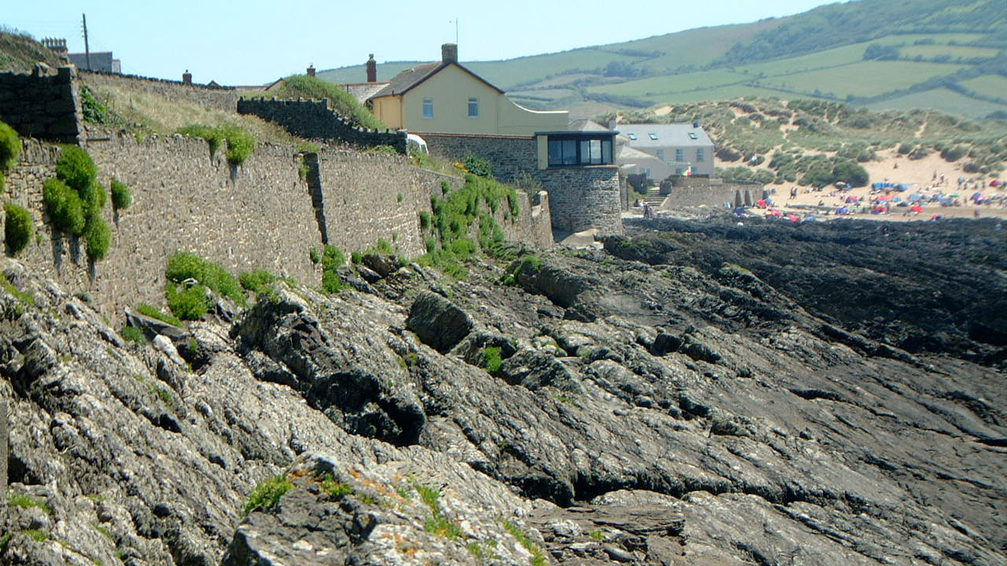
Overview
Directions
- Approach Croyde by the signed local roads and follow signs towards the National Trust Baggy Point car park on Moor Lane. The final approach is narrow and can be busy; the National Trust advises against vehicles longer than 6 m. Check its current parking information before travelling.
- The National Trust provides toilets and a tea room. It uses JustPark for member check-in and visitor payment, and warns that mobile signal can be limited, so arrange access to the parking service before arrival. Its visitor page gives EX33 1PA, while the official short-walk starting point gives EX33 1FF and grid reference SS 432 397. Use the signed car-park entrance and the landowner’s current directions rather than assuming these postcodes identify the same exact point.
- Use the recognised beach access towards Croyde Bay for the nearer rocky margins. Follow the signed coast path for the upper Baggy Point walk. Geological sections on the northern and outer headland are separate, more exposed destinations; do not treat this guide’s older-to-younger account as a continuous safe shore route.
- Plan any foreshore visit around tide times, swell and a dry return route. The bathing beach, rock pools and outer reefs have different hazards. Do not enter caves or cross channels to reach another exposure.
- Ref: 51.13474°N, 4.24216°W. This preserves the original guide reference; it is not a guarantee of a safe shore descent.
Location photographs
Swipe to browse · Select a photograph to enlarge


Fossil Hunting
This guide covers the rocky margins of Croyde Bay and the Baggy Point headland. The sandy bathing beach and the exposed outer headland offer very different conditions. For a first look at the fossils, concentrate on safely accessible, naturally weathered surfaces around the bay rather than attempting to follow the entire rock platform round the point. Keep a record of which side of the bay each specimen came from: the familiar “Baggy Beds” do not account for all the fossil-bearing rocks here.
The northern and southern margins of Croyde Bay expose the lower Pilton Mudstone Formation. Thin limestone bands, calcareous sandstone and shelly layers within grey mudstone contain a more varied marine fauna than the underlying Baggy Sandstones. Weathering can remove the original carbonate, leaving brown, friable patches and impressions of shells. Examine these surfaces with a hand lens and light from the side. A hollow impression can preserve more useful detail than a rough lump of shell, so do not dismiss moulds or brush them aggressively.
Brachiopods and crinoid debris are useful starting points. Published collections from the northern foreshore include the brachiopods Whidbornella caperata, W. pauli, Steinhagella steinhagei, Mesoplica praelonga and Crurithyris unguiculus. Look for curved shell outlines and ribs, and for the small discs or short jointed pieces left by crinoid stems. Many fragments cannot be identified to species. Fine, net-like impressions may be bryozoans: Fenestella plebeia, F. polyporata and forms compared with F. umbrosa were recorded from the reefs on the north side of the bay.
Bivalves documented from these northern reefs include Ptychopteria damnoniensis, Prothyris contorta, Aviculopecten transversus and Streblopteria piltonensis, with further material assigned tentatively to Palaeoneilo and other genera. Coiled gastropods and straight-shelled cephalopod fragments also occur in the published collections. These names describe scientifically recorded material, rather than a checklist that every visit will produce. Worn, compressed or incomplete shells should be labelled conservatively.
The reefs close to the mouth of Laticosta Cave are a documented fossil locality in the basal Pilton beds. An enrolled trilobite was recorded there as Phacops (Omegops) accipitrinus accipitrinus; the northern bay has also yielded the small echinoderm Calyptactis perarmatus. Other less conspicuous northern records include the ostracod Kloedenia, uncertain Penniretepora and Protarthraster near Laticosta Cave, and a solitary coral and Torynifer? microgemma near the southern end of the northern reef sequence. Such finds are much less routine than shell fragments and crinoid debris. The historical cave records are not a reason to enter the cave or to extract material from its walls. Photograph unusual fossils in place, note their position and seek specialist advice before disturbing them.
The southern margin has its own documented assemblage. Collections towards northern Down End include Mesoplica praelonga, cf. Chonetes sauntonensis, cf. Plicochonetes margaritaceus, cf. Whidbornella caperata, cf. Hamlingella goergesi, cf. Crenipecten auritus and material compared with Hydriocrinus? barumensis, with crinoid debris throughout the six recorded southern-margin reefs. The comparison marks matter: these are not all certain species identifications. Records farther round Down End include additional brachiopods and bivalves, separately located in the detailed account.
Farther out on Baggy Point, the Baggy Sandstones Formation contains alternating sandstones, siltstones and mudstones. Shell-rich sandstone patches and thin limestone lenses are irregular, and the surrounding rock may appear almost barren. The coastal succession has yielded Lingula, bivalves historically called “Cucullaea” unilateralis, Ptychopteria damnoniensis and Prothyris contorta. Fossil burrows can be more conspicuous than body fossils. Diplocraterion yoyo records a U-shaped dwelling burrow whose occupant adjusted its position as sediment accumulated or was eroded; Arenicolites curvatus and Monocraterion are also documented from the headland. Look for repeated, organised structures crossing or disturbing the bedding, while remembering that ripple marks and load casts were made by sedimentary processes rather than animals.
Historical descriptions of the Baggy Beds also record Teichichnus cf. rectus and Monocraterion cf. tentaculatum. These are comparative identifications; “Tentaculatum” is not a separate genus. Arenicolites curvatus was described both in its original burrowing position and as eroded tubes in conglomerates, with cemented sediment surrounding individual tubes. These study-wide observations help recognition but do not identify a particular reef or bed within this guide.
Plant debris occurs in some Baggy sandstones, but the famous plant assemblage belongs to the historical Croyde Hoe quarry. Its records include foliage historically assigned to Sphenopteridium rigidum and Sphenopteris, sporangial clusters originally called Telangium, and the early seed-bearing structures Xenotheca devonica. The quarry was described as unavailable in the geological conservation account, so this material should not be expected in ordinary foreshore collecting. Sparse fish remains have also been reported from the headland, including a loose plate tentatively assigned to Bothriolepis from the old Croyde Hoe pit and a fish tooth from a separate track excavation collected in 1970; the better-known fish-bearing tuff near Woolacombe is a different exposure and is outside this guide.
The cliffs and shore lie within the Saunton to Baggy Point Coast SSSI. Leave bedrock, cliff faces, raised-beach deposits and large blocks intact. Check current National Trust advice before taking even small loose specimens, collect sparingly only where permitted, and favour photographs where the fossil is fragile, unusual or part of an important exposed surface.
Fossil photographs
Swipe to browse · Select a photograph to enlarge


Discoveries and milestones
A chronological record of fossil discoveries, geological research and conservation milestones at Croyde Bay and Baggy Point.
1837 – Raised beaches brought to scientific attention
David Williams described raised beaches at Saunton Downend and Baggy Point, helping establish the coastal deposits as evidence of former shorelines rather than part of the much older Devonian bedrock.
1841 – An early fish record from Baggy Point
John Phillips recorded a fish scale from Baggy Point. The record is an early indication of vertebrate remains in the local Devonian succession, although it does not justify treating fish fossils as common finds.
1887 – The raised-beach interpretation questioned
T. McKenny Hughes examined the coastal marine sediments, blown sand and overlying rubble. He questioned whether all of the apparent raised-beach evidence required a former higher sea level, beginning a debate that later work refined rather than simply resolving with one date.
1907 – Croyde Hoe’s plant locality discovered
Dr Young discovered the plant-bearing locality at Croyde Hoe on Baggy Point. Its thin, discontinuous shales later provided material described by Arber and Goode, including early seed-plant structures.
1915 – Early seed-plant material described from Croyde Hoe
E. A. Newell Arber and R. H. Goode described the plant fossils of Croyde Hoe, including the cupulate structures named Xenotheca devonica. Surviving syntypes from this locality are held at Cambridge, making the historical quarry important to the study of early seed plants.
1926 – Further material added to the Croyde Hoe plant record
I. Rogers described additional Xenotheca devonica material from its type locality. Specimens from this work later contributed to a reassessment of the plant’s reproductive structures.
1955–1957 – The Pilton fauna used to refine the succession
Roland Goldring’s work on trilobites and brachiopods clarified the age and subdivisions of the Pilton beds. The lower coastal succession at Croyde, including the fossiliferous beds around Laticosta Cave, became part of the evidence distinguishing the Late Devonian fauna from younger assemblages elsewhere.
1962 – Two characteristic burrows formally described
Roland Goldring named Diplocraterion yoyo and Arenicolites curvatus in his study of Baggy trace fossils. Their structures helped explain how burrowing animals responded to deposition, erosion and early cementation on the ancient sea floor.
1968–1979 – Detailed mapping and fossil collections documented
Geological remapping of Croyde in 1968 was followed by a detailed published account in 1979. The work recorded individual sandstone packages around Baggy Point, the folded Pilton succession and fossil collections from precisely located coastal reefs, providing a much firmer basis for comparing finds from different parts of the shore.
1971 – Baggy Point developed as a shallow-water sedimentary model
Roland Goldring’s detailed study related the headland’s sandstone and mudstone packages, fossils, burrows and erosion surfaces to changing shallow-marine and river-influenced environments. It established the importance of the succession beyond its individual fossil finds.
1986 – The coast’s geological interest formally protected
The Saunton to Baggy Point Coast SSSI was notified on 21 November. Its protected features include the Baggy succession, Lower Pilton exposures and Laticosta Cave, together with the raised shore platforms, erratic boulders and younger coastal sediments.
1987 – Seeds recognised within historical Croyde Hoe specimens
Muriel Fairon-Demaret and Stephen Scheckler reported that re-examination of historical Xenotheca devonica specimens revealed enclosed seeds. This strengthened the interpretation of the Croyde Hoe fossils as early seed-plant reproductive structures.
1993 – Spore assemblages refine the age of the Croyde succession
Micheál O’Liathain published a palynological study including six new productive samples from Baggy Point and Croyde Bay. Successive LL, LE and LN spore assemblages confirmed an uppermost Devonian sequence; the Devonian–Carboniferous boundary identified in the wider investigation was at Fremington Pill.
1998 – The younger coastal record reassessed
A detailed geological conservation synthesis brought together the evidence from Croyde’s platforms, erratics, raised beaches, cemented sand and head. Contrasting dating results and sedimentary interpretations showed why these deposits could not be reduced to a single simple raised-beach sequence.
1999 – The early seed plant reassessed
J. Hilton and Dianne Edwards published new data on Xenotheca devonica, the early seed-plant structure first described from Croyde Hoe. The study continued the scientific reassessment of this historically important material.
2024 – Uncertainty in the Quaternary history retained
A modern reassessment revisited the deposits around Croyde, including the contrasting layers of head at Middleborough. It emphasised that such layers need not represent separate cold stages and that older amino-acid age estimates for the raised beaches remain uncertain.
Geology
Croyde records a Late Devonian shoreline gradually overtaken by the sea. Around Baggy Point, the Upcott Slates Formation is succeeded by the Baggy Sandstones Formation and then by the Pilton Mudstone Formation. The Baggy and Pilton formations are assigned to the Exmoor Group by the BGS. The accessible rocks around Croyde Bay belong chiefly to the lower Pilton succession. Although the complete Pilton formation extends into the Carboniferous elsewhere, the beds on this coastal stretch are Late Devonian, of Famennian age. The Devonian–Carboniferous boundary should not be placed on Croyde beach.
The Upcott Slates are best developed along the northern side of the headland. Their coloured mudstones and siltstones, with subordinate fine sandstone beds, record low-energy continental and marginal environments. They are sharply but conformably overlain by the Baggy succession. The latter is about 440–450 m thick in published accounts of its coastal type section, although faulting affects parts of the exposure. It is not one massive sandstone: resistant sandy packages alternate with softer mudstone and siltstone, producing the small projecting reefs and intervening inlets.
These changes reflect a shifting, river-influenced coast. Cross-bedding records migrating sand bodies; shell debris and fragments of earlier sediment occur in beds reworked by currents and waves. Other intervals preserve plant material washed into the depositional area or dense burrowing of the sea floor. The different fossil assemblages belong to different sedimentary settings, explaining why a small shelly or burrowed patch can be surrounded by rock with few obvious fossils. Near the top of the Baggy Sandstones, a conspicuous slumped bed contains contorted masses of sandstone and siltstone formed before the sediment had hardened. The overlying sandstone marks the boundary used by modern BGS accounts with the Pilton Mudstone.
The Pilton rocks contain more mud and a diverse marine fauna. Thin calcareous beds and limestone lenses preserve brachiopods, bivalves, bryozoans and crinoids, but weathering commonly dissolves carbonate and leaves moulds in a soft brown residue. Folding and cleavage subsequently changed the shape of both rocks and fossils. The beds are steeply inclined on the northern side of Croyde Bay, while the southern margin and Down End expose repeated folded layers. The distance walked across the shore therefore cannot simply be converted into the thickness or age of the succession.
A much younger history is visible above the Devonian rocks. Old wave-cut platforms support patches of rounded beach gravel, shell-bearing sand and cemented former dune sand, with stony head deposits interleaved with, above or against them; at Pencil Rock, head also lies beneath the sandrock. Around Middleborough and towards Pencil Rock these Quaternary deposits contrast sharply with the steep bedrock beneath. Large foreign boulders also survive on the old platforms. Their transport history, and the exact ages and correlations of the beach deposits, have been debated for many years; the whole cover should not be assigned one simple age. These deposits record changing sea level, wind-blown sand and cold-climate slope processes, and are a separate conservation interest from the Devonian fossils.
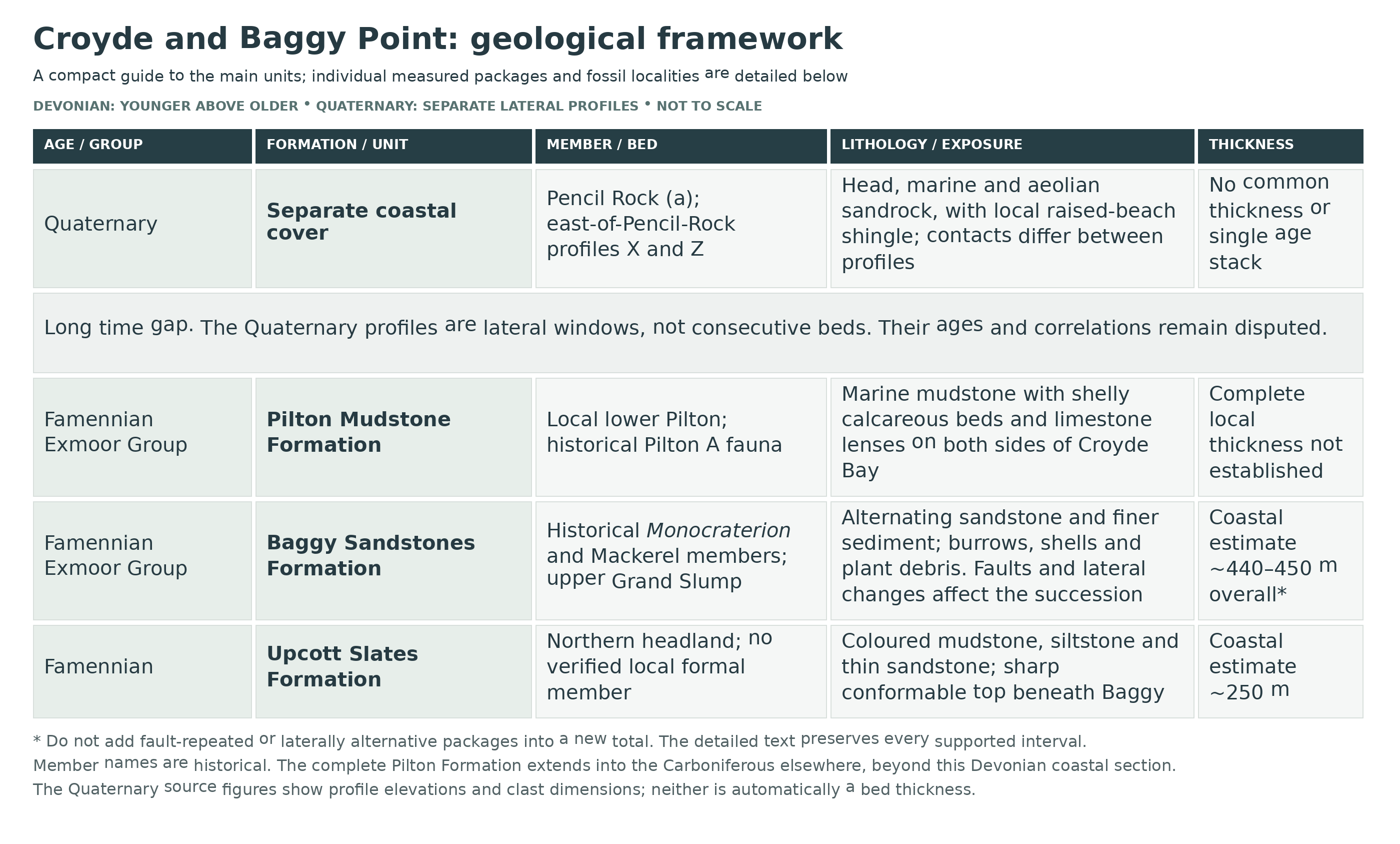
Detailed geology and bed-by-bed succession
The detailed Late Devonian succession around Baggy Point and Croyde Bay, followed by its much younger coastal deposits.
The following account runs from older to younger rocks around the Baggy Point headland and the two rocky margins of Croyde Bay. It describes published exposures, not a continuous safe walking route. Thicknesses refer to individual logged packages unless otherwise stated. The numbered sampling horizons used in palynological studies are not formal beds, and the local member names below follow the historical detailed subdivision rather than a complete modern mapped member scheme.
Upcott Slates Formation
Northern side of the Baggy Point headland
Grey, green, purple and locally buff or cream slates and silty slates contain subordinate siltstones and fine sandstones. The formation is exposed between Napps Cliff and Whiting Hole, largely in a near-strike section. Its estimated coastal thickness is about 250 m, not the height of any cliff. At Napps Cliff, the transition from the underlying Pickwell Down sandstones occupies about 9 m as sandstones become finer and thinner upwards. This eastern boundary is geological context for the headland, rather than the main Croyde Bay collecting area.
Upper Upcott beds and the Baggy boundary
North-coast exposures contain small faults, steep bedding and local folding. The thin sandstones commonly preserve cross-lamination; indeterminate shell fragments and sinuous sand-filled grooves have also been described. Some recorded grooves are 250–300 mm deep and about 200 mm broad; these are groove dimensions, not bed thicknesses. About 160 m south of Whiting Hole, at SS 4215 4086, slates, silty slates and siltstones dip steeply south-south-west beneath the basal Baggy sandstone. The contact is sharp but conformable, with load casts pressed into the topmost mudrock. No finer formal member subdivision is established for this section.
EXMOOR GROUP
The Baggy Sandstones and Pilton Mudstone formations are explicitly assigned to the Exmoor Group in the BGS Lexicon. The regional group spans a much larger Devonian–early Carboniferous succession, but its coastal rocks described here are Famennian; younger Carboniferous Pilton strata occur elsewhere. The preceding Upcott account is retained in its correct stratigraphic position without implying that its separate Lexicon entry specifies a formal parent group.
Baggy Sandstones Formation
Historically called the Baggy Beds, this formation has a partial type section around Baggy Point. Published estimates are about 440–450 m for the coastal succession; faulting affects part of the middle interval, and individual beds need not persist along the coast. The more sandstone-rich lower division passes into a muddier upper division. The succession below retains the measured packages described in the geological memoir without inventing names for unnamed beds.
Basal Baggy interval, about 45 m
Above the sharp basal contact, about 45 m of shale, siltstone and thin sandstone becomes sandier upwards west of the old coastguard lookout.
Long Rock sandstone, about 7 m
The succeeding sandstone package forms Long Rock at SS 4205 4082. Its fine sandstone is locally feldspathic, micaceous and shelly.
Baggy Hole intervening beds
The next mudstone–siltstone interval contains thin sandstones and ripple-marked surfaces around Baggy Hole. Uncertain lingulid and bellerophontid remains were recorded near its top. No thickness is specified for this interval.
Burrowed sandstone reef, about 5 m
The succeeding fine feldspathic and calcareous sandstone at SS 4210 4076 contains Arenicolites curvatus and Diplocraterion yoyo.
Shelly fine-grained interval
About 19 m of greenish-grey shale and siltstone follows at SS 4210 4075. Sandstone interbeds are most frequent near the bottom and top, and very thin shelly limestones occur. Recorded fossils include Lingula squamiformis, Echinocaris sloliensis, E. whidbornei, Prothyris contorta, Edmondia, Sanguinolites complanatus, Bellerophon subglobatus and material assigned to Actinoceras. These are published historical identifications.
Sandstone of the small promontory
At SS 4207 4074, about 18 m of thickly bedded to massive sandstone separates two coves. It includes feldspathic and calcareous cross-bedded beds, platy micaceous sandstone, wisps and lenses of muddy sediment, and shale-pellet conglomeratic layers towards the bottom.
Plant-bearing channel sandstone
Further shale and siltstone, locally forming a small cave, is sharply and irregularly overlain by about 17 m of sandstone at SS 4208 4071. Fine cross-bedded beds alternate with thin calcareous, micaceous and feldspathic sandstone and shale-pellet conglomerate. Abundant plant debris helped support an interpretation as sediment filling a distributary channel.
Bioturbated fine-grained interval, about 12 m
Shale, siltstone and thin sandstone becomes finer upwards and contains extensive Diplocraterion yoyo burrowing. A bedding-parallel fault occurs near SS 4210 4068. Ferruginous staining affects up to 2 m of the surrounding strata; that measurement describes the extent of alteration, not a separate sedimentary bed.
Faulted sandstone package, about 8 m
In the next cove, near SS 4209 4067, massive and locally flaggy sandstone beds are separated by a 1 m shale intercalation from plant-bearing cross-bedded upper sandstone. A strike fault apparently repeats this sandy interval near SS 4203 4067; it must not be counted twice in estimating the total succession. In the beds between the repeated exposures, Diplocraterion yoyo burrows penetrate the sediment by as much as 150 mm. This is burrow penetration, not the thickness of a fossil bed.
Monocraterion Member
This historical local member name applies to a coarser sandstone assemblage on the northern side of Baggy Point at approximately SS 4204 4067. Its upper beds contain Monocraterion burrows. At SS 4204 4067, the recorded fossils are an uncertain bellerophontoid, Ptychopteria damnoniensis and “Cucullaea” unilateralis. The separate collection at SS 4204 4065 contains cf. Lingula squamiformis and Palaeoneilo sp. The nearby faulted sandstone measurements do not securely define a separate complete thickness for the member.
Fine-grained beds above the Monocraterion Member, about 5 m
Thinly bedded shale, siltstone and sandstone overlie the historical member.
Overlying cross-bedded sandstone, about 5 m
Fine cross-bedded sandstone irregularly overlies the preceding fine-grained package. It contains plant debris, load casts and flute casts.
Northern-tip sandstone package, about 15 m
Farther up the sequence, the sandstone package at SS 4190 4067 includes an irregular-based plant-bearing unit, a 2 m silty-shale interval with plant fragments, lens-bedded feldspathic sandstone and thicker micaceous beds with shale pellets and a thin calcareous band. Calcareous sandstone or sandy-limestone pebbles occur in the shale above.
Lowest tip sandstone package, about 6 m
At SS 4190 4065, fine cross-bedded sandstone is locally micaceous. It contains shale pellets low in the package and plant-bearing feldspathic sandstone higher up. Shale with subordinate siltstone and fine sandstone separates this package from the next.
Middle tip sandstone package, about 16 m
At SS 4189 4064, the sandstone begins irregularly and contains cross-bedding, plants and subordinate shale. Shale pellets and “Cucullaea” unilateralis occur towards its top. Further shale with subordinate siltstone and fine sandstone separates it from the highest package.
Highest tip sandstone package, perhaps 17 m
At SS 4187 4061, fine cross-bedded sandstone has conglomeratic lower beds, plant debris, thin bioturbated sandstone and a thin sandy limestone.
Mackerel Member
At SS 4195 4057 on the south side of the point, shale and siltstone is overlain by up to 8 m of cross-bedded sandstone with load casts. Rounded fragments of calcareous sandstone occur in the lower part, where calcarenite was also reported. This historical member marks the top of the closely spaced, sandstone-rich lower division. It is not the formation boundary: a substantial muddier interval and further sandstones lie above.
Upper fine-grained interval
Shale and siltstone with scattered fine sandstone continue south-east from the point. This interval was estimated to exceed 80 m and becomes sandier upwards. Calcareous feldspathic sandstone occurs near SS 4207 4042.
Upper shelly sandstone package
An approximately 11 m package near SS 4215 4035 begins with strongly cross-bedded shelly sandstone. Micaceous sandstone with locally derived conglomeratic lenses and shale interbeds follows, then further cross-bedded sandstone containing shell debris. Thin, discontinuous crinoidal limestone bodies occur in silty sediments above; these pass into the shale–siltstone–thin sandstone association with Diplocraterion yoyo near SS 4221 4031.
Laterally variable upper beds and boulder bed
A few metres of irregular-based cross-bedded fine sandstone at SS 4220 4030 contain shale pellets, shell debris and a limy conglomeratic upper band. Fossils recorded here include Whidbornella caperata, Hamlingella goergesi and Ptychopteria damnoniensis. The sandstone disappears in the corresponding section near a cave at SS 4234 4025, where a 1.5 m boulder bed contains angular and rounded fine-sandstone blocks in silty matrix. These are laterally changing deposits, not two beds to add uncritically into one vertical stack.
Separate upper-Baggy cliff collection
The nearby cliff at SS 4228 4023 yielded historically identified “Bellerophon” sp., an indeterminate gastropod, “Orthoceras” sp., Palaeoneilo?, Ptychopteria damnoniensis, a myophoriid bivalve and crinoid debris. This is a separately located collection; the record does not place it specifically within the boulder bed.
Grand Slump, around 6 m
The prominent slumped unit extends approximately from SS 4221 4024 to SS 4245 4015 and thins out eastwards. It is irregular and contains contorted, rounded masses of sandstone and siltstone; the fine-grained beds beneath are variably disturbed. Gravity-driven submarine slumping explains the structure without requiring the older suggestion of sand-volcano activity.
Topmost Baggy sandstone, around 5 m
Fine cross-bedded sandstone overlies the Grand Slump. It is locally feldspathic, calcareous or micaceous, with shale-pellet conglomeratic developments near the top. The top of this sandstone is the Baggy–Pilton boundary adopted in the BGS account.
Other historical Baggy trace descriptions
Historical descriptions of the Baggy Beds also record Teichichnus cf. rectus and Monocraterion cf. tentaculatum. These are comparative identifications; “Tentaculatum” is not a separate genus. Arenicolites curvatus was described both in its original burrowing position and as eroded tubes in conglomerates, with cemented sediment surrounding individual tubes. These study-wide observations help recognition but do not identify a particular reef or bed within this guide.
Depositional facies and the Croyde Hoe plant locality
Fine-grained, burrowed deposits and the graded sandstones of the Reynard facies represent the shallow marine background. Shelly Rough facies, well-sorted Gull facies and burrowed Arenicolites facies record other nearshore settings. Lingula-rich beds were interpreted as restricted-bay or lagoonal deposits. Plant-bearing Timber and Cormorant facies represent channel fills, while the finer Hoe facies records low-flow conditions, possibly freshwater lakes. Tag facies has a less certain interpretation. These facies recur and must not be arranged as if each were a unique member. The historical plant material from Croyde Hoe quarry came from one thin lens of silt and shale of the Hoe facies within a Timber-facies quarry. The original 1915 description records highly discontinuous plant-bearing shale less than one inch (about 25 mm) thick. Its figured Croyde organs include Sphenopteridium rigidum, Sphenopteris sp., Telangium sp. and Xenotheca devonica. These are historical organ identifications, not a reconstruction of one complete plant.
Other historical headland collections
Separate coastal-footpath exposures yielded Palaeoneilo? at SS 4208 4047 and cf. Ptychopteria damnoniensis at SS 4223 4036. These records are geographically distinct from the cliff and quarry assemblages.
Croyde Hoe old pit, SS 4279 4033
The old pit exposes sandstone with subordinate shale dipping approximately 50° towards 210°. The geological memoir identifies it only as probably the quarry worked for plants by Arber and Goode and later Rogers. Butler’s collection contained uncertain camarotoechiids, indeterminate rhynchonellacean and lingulid brachiopods, “Cucullaea” unilateralis and a loose plate tentatively identified as Bothriolepis. The loose plate has no securely demonstrated bed-level provenance. This is a historical excavation record, not advice to visit or reopen a quarry.
Separate Croyde Hoe track excavation, SS 4279 4026
Brown and grey fine sandstone, pale buff micaceous sandstone, silty shale and a thin weathered limestone dip approximately 40° towards 220°. Goldring recorded Cyrtospirifer verneuili, Sanguinolites sp. and Echinocaris sp., comparing the fauna’s age with that of the lower Pilton beds. Butler’s separate 1970 collection included a plant fragment, cf. Cyrtospirifer verneuili, indeterminate spiriferacean and strophomenacean brachiopods, cf. “Macrochilina” pusilla, a gastropod with an uncertain generic identification, a juvenile bellerophontoid, indeterminate gastropods and an orthocone, Prothyris contorta, uncertain nuculanids and other indeterminate bivalves, Echinocaris whidbornei, ostracods, crinoid columnals and a fish tooth. It must not be merged with the old pit’s loose fish-plate record.
Baggy palynological horizons
In the published spore study, sample CR4 came from grey mudstone north of Baggy Point about 20 m above the formation base, with a diverse, well-preserved assemblage. CR9 came from dark grey mudstone beside a cliffside path about 40 m below the author’s formation top and contained diverse, abundant spores. Both were assigned to the Retispora lepidophyta–Knoxisporites literatus (LL) Biozone. CR10, about 6 m below the Grand Slump, yielded the younger Retispora lepidophyta–Hymenozonotriletes explanatus (LE) assemblage. The rarity of Hymenozonotriletes explanatus in CR10 suggests a position near the base of its zone. These samples refine the late Famennian age; their positions follow that author’s section and boundary convention. The same study also plots Dolby’s earlier 1970 sample series. Higgs and colleagues assigned those earlier Baggy assemblages to LL and lower Pilton assemblages to LE in 1988; the later CR10 result extended the recognised LE record down into the upper Baggy succession. The earlier sample numbers are collection horizons, not named beds.
Pilton Mudstone Formation
The older names Pilton Beds and Pilton Shales refer to this formation. Grey mudstone and siltstone with sandstone and thin limestone pass gradually upwards from the Baggy succession. Its complete Famennian–Tournaisian age range and regional thickness must not be applied wholesale to Croyde: this coast exposes its Devonian lower part. Historical terms such as “Lower Pilton” and the faunal division “Pilton A” are not separate formations in the modern scheme.
Basal beds and Laticosta Cave
From the south-eastern side of the Baggy headland towards the northern edge of Croyde Sand, shale, silty shale, fine sandstone and thin limestone make up the basal succession. Calcareous beds commonly weather brown and friable. At Laticosta Cave, SS 4270 4004, the beds dip steeply south-south-west and preserve sedimentary evidence that they are the right way up. Historical cave records include Sinotectirostrum? laticosta, Hamlingella goergesi and Athyris; the nearby reefs separately yielded trilobites, bivalves, brachiopods and crinoid debris.
Northern Croyde Bay reefs
Beds dip mainly south to south-south-west, locally becoming vertical. Ripple marks, load structures, open folds and small faults are present. Towards Middleborough and the old limekiln some beds are overturned. Thin calcareous layers contain the documented shelly assemblages, but no complete numbered bed scheme is established for these individual reefs. The fossiliferous intervals should be described by their documented position and matrix rather than assigned invented bed names.
Southern margin and Down End: thin-bedded background
At the southern end of the beach, near SS 4339 3882, slightly papery shale alternates with thin sandstone and limestone. The folded succession continues around Down End, with repeated layers rather than a simple uninterrupted dip section. The following measured beds belong to the wider southern-margin section, not the main sandy beach.
Faulted northern Down End sandstone, up to 1.2 m
Near the northern side of the promontory, a hard massive sandstone at SS 4318 3870 is displaced by 1.8 m along an east-north-east-trending fault. The 1.8 m value is fault displacement; the bed itself is up to 1.2 m thick.
Four stronger Down End beds, each 0.3–0.6 m
Four massive, knobbly sandstone beds dip steeply south at SS 4324 3867. The stated range applies to each bed, not to the whole intervening succession.
Three folded Down End sandstones, each about 0.6 m
Farther round the promontory, three sandstone beds lie in tight upright folds near SS 4307 3850.
Separate sandstone and quartz veins, about 0.6 m
A distinct sandstone band runs slightly north of west across the floor of a small cove at SS 4314 3837. Sheared and broken quartz veins occur in its neighbourhood. It is a separate logged exposure, not an additional description of one of the three preceding beds.
Tuffaceous marker horizons
Thin pale bands south of Croyde beach have been interpreted as volcanic ash deposits and used to trace the folded Pilton succession. A later study describes two creamy-white tuff bands; the memoir identifies thin weathered bands considered tuffaceous at SS 4318 3860, SS 4314 3832 and SS 4322 3824 around Down End, the latter two farther south on the promontory. The number of exposures is not necessarily the number of original beds because the sequence is repeated by folding. They must not be confused with the fish-bearing tuff of the Pickwell Down succession towards Woolacombe.
Published Pilton reef collections: geographic records, not named beds
The following A–Q letters are the geological memoir’s collection localities. A–C adjoin Laticosta Cave, D–I lie on the northern bay, J–O lie on the southern margin and northern Down End, and P–Q extend farther around Down End within the wider section described above. The identifications are historical; cf. means compared with, aff. indicates affinity, and question marks retain uncertainty. Repeated names represent separate collections. These records do not imply abundant finds or permission to extract specimens.
Reef A, SS 4270 4006 (Laticosta reefs)
Recorded material comprises Whidbornella; cf. Centrorhynchus letiensis; indeterminate spiriferaceans; Ptychopteria damnoniensis; crinoid debris; an uncertain tentaculitoid.
Reef B, SS 4269 4005 (Laticosta reefs)
Recorded material comprises aff. Fenestella umbrosa; Penniretepora?; rhabdomesid?; cf. Chonetes sauntonensis; indeterminate rhynchonellaceans; Crurithyris unguiculus; Cyrtospirifer?; Kloedenia sp.; crinoid debris; Protarthraster?.
Reef C, SS 4269 4004 (Laticosta reefs)
Recorded material comprises cf. Ptychomaletoechia omaliusi; indeterminate gastropods; ‘Orthoceras‘ sp.; cf. Palaeoneilo tensa; Paracyclas?; Phthonia?; Prothyris contorta; Ptychopteria damnoniensis; Sanguinolites sp.; Phacops (Omegops) accipitrinus accipitrinus; crinoid debris.
Reef D, SS 4285 3991 (northern bay)
Recorded material comprises Fenestella plebeia; cf. Chonetes sauntonensis; indeterminate productaceans; indeterminate rhynchonellaceans; indeterminate spiriferaceans; ?‘Cucullaea’ unilateralis; ? pectinacean; crinoid debris.
Reef E, SS 4295 3978 (northern bay)
Recorded material comprises Fenestella; Whidbornella caperata; Whidbornella pauli; cf. Centrorhynchus letiensis; cf. Crurithyris unguiculus; cf. Cyrtospirifer verneuili sensu Vandercammen 1959; Leptodesma (Leptodesma) aff. mytiliforme; Palaeoneilo?; ? Sanguinolites sp.; Streblopteria?; Phacops?; crinoid debris.
Reef F, SS 4304 3973 (northern bay)
Recorded material comprises ? Centrorhynchus letiensis; cf. Cyrtospirifer verneuili sensu Vandercammen 1959; crinoid debris.
Reef G, SS 4329 3960 (northern bay)
Recorded material comprises ? Fenestella plebeia; Mesoplica praelonga; cf. Centrorhynchus letiensis; Athyris?; cf. Aviculopecten transversus; Streblopteria?; pterineid?; crinoid debris.
Reef H, SS 4327 3957 (northern bay)
Recorded material comprises Fenestella plebeia; Fenestella polyporata; cf. Fenestella umbrosa; rhabdomesid?; indeterminate bryozoans; dalmanellid?; indeterminate chonetaceans; Rhytiophora?; Steinhagella steinhagei; Whidbornella pauli; cf. Centrorhynchus letiensis; cf. Athyris concentrica; Athyris?; Composita?; Cyrtospirifer?; indeterminate gastropods; Aviculopecten transversus; Aviculopecten?; Cypricardella?; Goniophora?; Mytilarca?; cf. Phacops (Omegops) accipitrinus accipitrinus; crinoid debris; Calyptactis perarmatus.
Reef I, SS 4327 3952 (northern bay)
Recorded material comprises solitary coral; Fenestella umbrosa; cf. Schellwienella crenistria; indeterminate chonetaceans; cf. Athyris concentrica; Crurithyris unguiculus; cf. Cyrtospirifer verneuili sensu Vandercammen 1959; Torynifer? microgemma; indeterminate gastropods; cf. Palaeoneilo lirata; Streblopteria piltonensis; crinoid debris.
Reef J, SS 4339 3887 (southern margin and northern Down End)
Recorded material comprises cf. Chonetes sauntonensis; cf. Cyrtospirifer verneuili sensu Vandercammen 1959; crinoid debris.
Reef K, SS 4339 3885 (southern margin and northern Down End)
Recorded material comprises indeterminate productaceans; ? indeterminate trilobite fragments; crinoid debris.
Reef L, SS 4335 3874 (southern margin and northern Down End)
Recorded material comprises cf. Chonetes sauntonensis; cf. Plicochonetes margaritaceus; Cypricardella?; crinoid debris.
Reef M, SS 4330 3872 (southern margin and northern Down End)
Recorded material comprises cf. Fenestella umbrosa; cf. Chonetes sauntonensis; Mesoplica praelonga; cf. Whidbornella caperata; cf. Cyrtospirifer verneuili sensu Vandercammen 1959; indeterminate trilobite fragments; crinoid debris.
Reef N, SS 4327 3865 (southern margin and northern Down End)
Recorded material comprises cf. Fenestella plebeia; Fenestella umbrosa; cf. Hamlingella goergesi; Mesoplica praelonga; cf. Crenipecten auritus; crinoid debris.
Reef O, SS 4320 3862 (southern margin and northern Down End)
Recorded material comprises cf. Hydriocrinus? barumensis; crinoid debris.
Reef P, SS 4316 3848 (farther Down End)
Recorded material comprises Whidbornella caperata; cf. Centrorhynchus letiensis; athyridacean?; indeterminate spiriferacean; Streblopteria piltonensis; crinoid debris.
Reef Q, SS 4327 3824 (farther Down End)
Recorded material comprises Centrorhynchus letiensis; athyridacean?; Ptychopteria damnoniensis.
Pilton spore horizons and age
Sample CR11, about 8 m above the Grand Slump, and CR14, from dark grey mudstone at a reconstructed level about 335 m above the lower Pilton base and about 30 m below the top of the northern exposed section, yielded LE-zone spores. CR15 from Cock Rock, near the core of a major syncline, yielded the rather poorly preserved Retispora lepidophyta–Verrucosisporites nitidus (LN) assemblage. The published log marks an 80 m gap in exposure between the northern section and CR15; this is not an established erosional unconformity or a continuous walkable succession. Together these records support an uppermost Devonian succession at Croyde. The Carboniferous VI-zone samples in the same investigation came from Fremington Pill and must not be transferred to this locality.
Quaternary cover: a separate, much younger succession
Raised shore platforms cut across the steep Devonian rocks. Patches of old beach deposits, cemented sand and head survive around Croyde Bay, particularly between Middleborough and Pencil Rock. Their contacts vary laterally, so the following is a framework rather than a single measured log.
Shore platforms and erratic boulders
The wider Croyde–Saunton coast has several platform levels. Foreign boulders include a large gneiss block at Freshwater Gut near SS 427 400. Ice rafting and transport associated with regional glaciation have both been discussed; the mechanism and chronology should not be presented as settled for every block.
Raised beach gravel and marine sand
Rounded pebbles and cobbles occur with coarse sand, shell debris and locally angular fragments derived from the older cliffs. Parts are strongly cemented. Deposits may rest directly on the Devonian platform or enclose large boulders; neither a uniform thickness nor one beach horizon can be followed everywhere.
Cemented dune sand and former soils
Marine sands locally pass into wind-blown sand, now cemented as sandrock or dunerock. Cross-bedding, terrestrial gastropods and former soil development help distinguish the dune component. Published interpretations recognise a progression through beach, intertidal, embayment, backshore and dune conditions, but the timing of these stages is disputed. Older luminescence and amino-acid interpretations do not provide one secure date for the entire Croyde cover.
Head and later slope deposits
Angular fragments of local bedrock, commonly in a sandy or earthy matrix, accumulated through cold-climate weathering and downslope movement. At Middleborough, a coarse slate-fragment layer lies between finer deposits. This variation need not represent separate glaciations. Reports of till in Croyde Bay remain disputed, and the head should not be labelled confidently as an in-situ glacial deposit.
Head cover and the separate stepped-platform profiles
The published headland map distinguishes a thin skin of head over much of Baggy Point from an inland area of about 2.5–3 m of head on its southern side. Separate profiles at Freshwater Gut, Laticosta Cove and below Baggy Cottages show differently stepped bedrock platforms and Pleistocene head terraces. Freshwater Gut includes the large granulite-gneiss erratic on the higher part of the platform and lower surfaces undercut by waves; Laticosta Cove shows a higher platform clearly beneath head, while the Baggy Cottages profile has a lower broad platform leading towards a terrace-backed step. The heights above Ordnance Datum in these profiles locate rock surfaces and terraces; they are not measurements of sediment thickness.
Pencil Rock: head beneath marine and aeolian sandrock
The published Pencil Rock section shows head banked against a sloping rock surface, passing down onto a low rock platform. Shale slivers form its basal part, with sandstone and shale blocks 30.5–122 cm long locally embedded in this material; a band with shale blocks 5–30.5 cm long lies above. Marine sandrock overlies this head and passes upwards into aeolian sandrock. The head therefore lies below the sandrock here, rather than only capping a simple beach–sand succession. The stated centimetre ranges are clast lengths, not bed thicknesses.
East of Pencil Rock: section X
The paired published sections X and Z illustrate local lateral changes east of Pencil Rock. In section X, raised-beach shingle occurs locally against the lower rock platform at the base of the deposit. Head containing shale blocks 10–61 cm long occupies the lower part of the sandrock, with scattered blocks continuing higher. The platform and sediment contacts differ from those in the adjacent section; this is a separate local section, not a younger package to stack above Pencil Rock.
East of Pencil Rock: section Z
Section Z rests against the higher part of the inclined rock platform. Basal head with shale fragments 2.5–10 cm long passes into material containing shale blocks 10–61 cm long. A conspicuous higher concentration contains larger shale blocks 61–91.5 cm long, while scattered angular blocks also occur in the overlying sandrock. Raised-beach shingle is drawn locally at X but is not separately marked at Z. The contrast demonstrates lateral changes in head, shingle and sandrock relationships. Heights plotted in the original diagram locate the sections vertically; they are not individual bed-thickness measurements.
References
British Geological Survey. Lexicon entries for Exmoor Group, Upcott Slates Formation, Baggy Sandstones Formation and Pilton Mudstone Formation.
Edmonds, E. A., Williams, B. J. and Taylor, R. T. 1979. Geology of Bideford and Lundy Island. Memoir of the Geological Survey of Great Britain. Chapters 2, 3 and 7; Appendix 1.
Goldring, R. 1962. The trace fossils of the Baggy Beds (Upper Devonian) of North Devon, England. Paläontologische Zeitschrift, 36, 232–251.
Goldring, R. 1971. Shallow-water sedimentation as illustrated in the Upper Devonian Baggy Beds. Memoirs of the Geological Society of London, 5.
O’Liathain, M. 1993. Stratigraphic palynology of the Upper Devonian–Lower Carboniferous succession in north Devon, southwest England. Annales de la Société géologique de Belgique, 115 (1992), 649–659.
Cleal, C. J. and Thomas, B. A. 1995. Plaistow Quarry account, including the historical Croyde Hoe plant locality. Palaeozoic Palaeobotany of Great Britain, Geological Conservation Review Series 9.
Campbell, S. and Gilbert, A. 1998. The Croyde–Saunton Coast. In Quaternary of South-West England, Geological Conservation Review Series 14.
Bennett, J. A., Cullingford, R. A., Gibbard, P. L., Hughes, P. D. and Murton, J. B. 2024. The Quaternary geology of Devon. Proceedings of the Ussher Society, 15, 84–130.
Arber, E. A. N. and Goode, R. H. 1915. On some fossil plants from the Devonian rocks of North Devon. Proceedings of the Cambridge Philosophical Society, 18, 89–104, plates IV–V. Croyde Hoe introduction, p92 discovery record and locality-specific specimen descriptions.
Waters, C. N., Browne, M. A. E., Dean, M. T. and Powell, J. H. 2007. Lithostratigraphical framework for Carboniferous successions of Great Britain (Onshore). BGS Research Report RR/07/01, p40, section 8.2. Defines the regional Exmoor Group but does not enumerate its Devonian formations.
Fairon-Demaret, M. and Scheckler, S. E. 1987. Typification and redescription of Moresnetia zalesskyi Stockmans, 1948, an early seed plant from the Upper Famennian of Belgium. Bulletin de l’Institut Royal des Sciences Naturelles de Belgique, Sciences de la Terre, 57, 183–199; Croyde Hoe material discussed on p188.
Safety
Check the tide, wind and swell before setting out, and leave plenty of time to return over dry ground. Reefs, inlets and the Baggy Point headland can be cut off as the tide rises. Never rely on wading a channel as an escape route, and turn back well before waves reach your route.
Croyde is an energetic surf beach with powerful waves and rip currents. Seasonal lifeguarding of the main beach does not make the rocky margins, caves or headland safe. Keep children close and away from water-filled channels and exposed rock pools, including on apparently calm days.
Wear footwear with good grip. Wet rock, weed, mud and steeply tilted bedding can all be slippery; keep clear of cliff bases, unstable overhangs and loose blocks. Do not enter sea caves or climb to a fossil exposure.
Leave bedrock and cliffs intact. Hard sandstone and slate can shed sharp fragments, while the fossil-bearing weathered material may crumble at a touch. Photograph delicate or unusual fossils in place. Carry a charged phone, tell someone your plans, and call 999 or 112 and ask for the Coastguard in a coastal emergency.
Equipment
Take grippy boots, suitable layers and waterproofs, a charged phone, tide and weather information, drinking water and a small first-aid kit. A hand lens, camera, scale and notebook are more useful than heavy tools for recognising moulds, shell ribs and burrows.
If the landowner permits collecting small loose pieces, bring tissue or soft wrapping, small rigid boxes and labels. Record the precise part of the bay or headland and whether a specimen was loose or in place. Hammers, chisels and digging tools are not default equipment for the protected bedrock.
Cleaning And Treating
Let damp specimens dry gently at room temperature. Weathered brown residues and natural moulds can carry most of the useful detail, so begin with observation and only a very soft dry brush on stable surfaces. Do not scrub, soak fragile material or force it from the surrounding rock.
Avoid acid, bleach, varnish and other treatments that can destroy shell material or obscure fine structures. Keep pieces and their labels together. Leave unusual, potentially significant or very friable finds unprepared until a specialist has advised on their care.
Identify Your Finds
Need help identifying a fossil? Share clear photos, where you found it and its size with the community.
Further Reading
Edmonds, Williams & Taylor (1979): Geology of Bideford and Lundy Island
BGS Lexicon: Baggy Sandstones Formation
BGS Lexicon: Pilton Mudstone Formation
Campbell & Gilbert (1998): The Croyde–Saunton Coast
Sedgwick Museum: historical Croyde Hoe syntype of Xenotheca devonica
O’Liathain (1993): Stratigraphic palynology of the Upper Devonian–Lower Carboniferous succession in north Devon
National Trust: Baggy Point visitor information
RNLI: Croyde Beach safety information
Access Rights
The shore and headland form part of the Saunton to Baggy Point Coast SSSI, designated for several geological and ecological interests. Designation does not itself give a right of access or permission to collect. Stay on public paths and recognised access routes, obey local signs and temporary restrictions, and respect landowners and other visitors.
Natural England’s management guidance recognises that responsible specimen collecting may be acceptable in some circumstances, while finite geological resources need particular care. This is not blanket permission to take any loose material. Check current National Trust or other landowner guidance before removing small loose specimens; leave bedrock, cliff faces, raised-beach deposits and large blocks undisturbed.
The famous Croyde Hoe plant quarry is a historical research locality, not a currently advertised collecting destination. Its specimens and records must not be taken as evidence that the quarry is accessible today. For designation details consult the official Natural England site record.
Original designation document: SSSI Information – Croyde
It is important to follow our ‘Code of Conduct’ when collecting fossils or visiting any site. Please also read our ‘Terms and Conditions‘
Links
♦ Fossil Discussions
♦ Fossil Articles
♦ Buy Fossils, Tools and Equipment
♦ Buy Crystals, Meteorites, and Artefacts
♦ Join Fossil Hunts
♦ UK Fossils Network


