
Overview
Directions
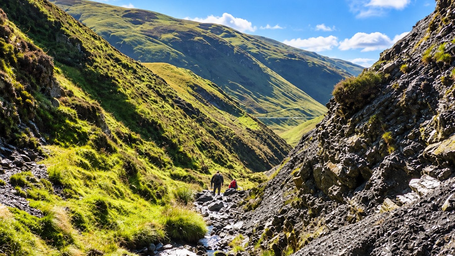
- Dob’s Linn lies north of the A708 between Moffat and Selkirk, north-east of Grey Mare’s Tail near Birkhill. Travelling from Moffat, the gorge is on the left beyond Grey Mare’s Tail.
- The small roadside parking area near NT 196154 gives the shortest approach. Use only safe available space, without obstructing the road, gates or access. Follow an OS map towards the Linn; the original guide’s locality reference is NT 19659 15827.
- The gorge is approximately 0.5 km from the road. The approach follows rough, inclined ground and narrow sheep tracks and crosses upland streams. There are no managed paths. The original guide allowed around 30 minutes from the parking entrance; conditions and the exact destination affect the time required.
- The NTS Grey Mare’s Tail car park at NT 186145 is a different parking place, about 1.5 km south-west, with a longer approach to Dob’s Linn. Check its current visitor information and charges. The waterfall path at Grey Mare’s Tail does not take you to the Dob’s Linn reference exposure.
Location photographs
Swipe to browse · Select a photograph to enlarge


Fossil Hunting
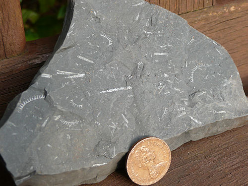
Graptolites are the principal attraction. These colonial animals lived in the sea above the accumulating mud, and their remains commonly appear as small dark, shiny or pyritic outlines on shale bedding surfaces. A hand lens brings out the repeated tooth-like cups along a colony. Look at naturally exposed surfaces in low, oblique light: a faint branching outline can be much clearer when the slab is tilted than when viewed straight on. Do not expect the large, robust, three-dimensional shells familiar from many younger fossil sites.
The most useful first distinction is between the rock types. Dark, finely bedded shale can be crowded with graptolites, while a neighbouring grey mudstone surface may show very little. The black Lower Hartfell beds and many Birkhill beds are fossiliferous through appreciable intervals, whereas the largely pale Upper Hartfell contains a small number of exceptionally important dark seams. The pale bands also include altered volcanic ash. Colour alone cannot identify a formation or biozone, and a single apparently barren surface is not a reason to break into the outcrop.
The Ordovician Lower Hartfell fauna includes branching colonies of Dicranograptus and Dicellograptus, alongside two-rowed forms historically placed in Climacograptus and Orthograptus. Recorded examples include Dicranograptus clingani, Dicellograptus morrisi and Dicellograptus elegans. The softer black shale at the top of the formation contains the characteristic Pleurograptus linearis assemblage. Branching pattern, colony width and the arrangement of the cups are useful observations, but broken or stretched specimens often need specialist identification.
The Upper Hartfell Complanatus and Anceps bands are thin markers rather than thick collecting beds. The two Complanatus bands contain Dicellograptus complanatus; the Anceps package includes Dicellograptus anceps, D. complexus and other biserial and branching forms. Some researched specimens preserve delicate spines or net-like structures. These fine details are easily lost from crumbling or heavily weathered shale. The detailed succession below explains the five Anceps bands and their changing thicknesses without treating every dark seam as the same horizon.
Birkhill graptolites record both the latest Ordovician fauna and the diversification of Silurian forms. The boundary association includes Akidograptus ascensus and Parakidograptus praematurus; early single-rowed graptolites such as Atavograptus ceryx occur higher in the measured basal section. Further up, curved or coiled monograptid colonies and delicate Rastrites occur among more varied assemblages. Names and zone limits used in the classic papers have changed, so an old label is not always a secure modern identification. In particular, the former “Rastrites maximus Zone” at Dob’s Linn was reassigned to the halli Biozone.
A few less conspicuous fossils broaden the story. The tiny phosphatic brachiopod Barbatulella lacunosa is documented from the upper Complanatus Band and the immediately overlying pale shale. Microscopic conodont elements occur in the Anceps package, and a rare blind dalmanitid trilobite, assigned to Sonxites, was recorded from a thin calcareous horizon below the historically named Extraordinarius Band. These are specialist or rare bed-specific records, not likely finds throughout the gorge. The small problematic fossil “Dawsonia” campanulata in the lower Birkhill remains biologically unresolved; the old interpretation as a graptolite egg sac has not stood up to re-examination.
Where the landowner expressly agrees to small-scale collecting from loose material and any necessary consent is in place, carefully examine already detached pieces rather than stripping a shale face. Keep the two halves of a useful split together, record the date and precise find position, and label any uncertainty over the source bed. Scree mixes material from several horizons, while folding and faults repeat the succession. A fossil picked up below a particular cliff cannot automatically be assigned to the bed directly above it. Photograph potentially important specimens with a scale and seek advice before further preparation or removal.
Dob’s Linn is a protected international reference section. Do not hammer, excavate or sample its in-situ exposures as part of a recreational visit. Contact the NTS Grey Mare’s Tail team to check present collecting arrangements; older field-guide statements about scree collecting are not current permission. If permission or consent is unclear, observe and photograph specimens in place.
Fossil photographs
Swipe to browse · Select a photograph to enlarge
Discoveries and milestones
A chronological record of fossil discoveries, geological research and scientific milestones at Dob’s Linn.
1851 – Early structural interpretation
Robert Harkness recognised the alignment of the Moffat shale inliers and interpreted shale beneath the surrounding greywackes, including a fault through Dob’s Linn. His model preceded modern thrust and accretionary interpretations, but it began the effort to explain the locality’s repeated outcrops.
1858–1859 – Early graptolite records published
William Carruthers’s Dumfriesshire graptolite paper, read in 1858 and reprinted in 1859, explicitly recorded Dobb’s Linn. It establishes an early documented fossil locality, although not every species discussed in that regional paper came from the Linn.
1867 – A locality based graptolite type
Carruthers described Dicellograptus elegans, whose type specimen Q850 comes from the Lower Hartfell at Dob’s Linn. Subsequent nineteenth-century work by Nicholson and Lapworth established many further names from locality material, giving the gorge an enduring taxonomic role.
1873 – The problematic “Dawsonia” named
H. A. Nicholson named “Dawsonia” campanulata from the Birkhill Shale at Dob’s Linn as part of a supposed group of detached graptolite reproductive bodies. That interpretation was later rejected; the small fossil remains of uncertain biological affinity.
1878 – Lapworth resolves the fossil succession
Charles Lapworth mapped and zoned the Moffat succession, using changing graptolite assemblages to distinguish beds repeated by deformation. Dob’s Linn became central to demonstrating that graptolites could correlate strata and help unravel complicated geological structure.
1899 – Geological Survey account revised
Ben Peach and John Horne redescribed Dob’s Linn with a map and section, revising details of Lapworth’s interpretation. Their work embedded the locality in the Geological Survey’s wider account of the Scottish Silurian rocks.
1901–1918 – Classic graptolite monograph
Gertrude Elles and Ethel Wood, working under Lapworth’s supervision, described and illustrated substantial Dob’s Linn material in their British graptolite monograph. The locality supplied numerous taxonomic reference specimens, alongside material from other British sections.
1929 – Akidograptus ascensus described
K. A. Davies revised graptolites from the Ordovician–Silurian transition and named Akidograptus ascensus. Its Dob’s Linn holotype, SM A10021, is preserved at the Sedgwick Museum. The species later became the principal marker for the base of the Silurian.
1930 – Lapworth commemorated at Birkhill
Scottish geologists erected the plaque at Birkhill Cottage commemorating Lapworth’s stays in 1872 and 1878 and his use of graptolites to interpret Southern Uplands stratigraphy. The commemoration records the locality’s history of field research.
1962 – Diplograptid evolution investigated
G. H. Packham used Birkhill Shale material in a study of early Silurian diplograptid evolution. Dob’s Linn is the type locality of Glyptograptus elegans Packham, adding another important taxonomic reference to its collections.
1968 – Forty-six Birkhill fossil horizons logged
Peter Toghill revised the Birkhill assemblages and biozones and documented 46 numbered fossiliferous horizons in an approximately 43 m composite succession. His recognition of the basal persculptus fauna and detailed upper log remain important, although later work revised the basal measurement and uppermost zonation.
1970 – Boundary stratotype proposed
Cocks, Toghill and Ziegler advanced Dob’s Linn as an Ordovician–Silurian boundary stratotype at the then proposed persculptus-zone level. Toghill also extended his taxonomic work to the Hartfell fauna. The eventual international boundary was adopted at a higher level than this early proposal.
1974 – Second Complanatus seam documented
J. K. Ingham’s published field work distinguished an upper Complanatus black-shale seam about 0.4 m above the lower one. Recognising two separate seams improved correlation through the mostly pale Upper Hartfell succession.
1979 – New mapping and international examination
Ingham’s detailed map provided a structural framework for intensive study of continuous sections. An international boundary working group examined Dob’s Linn during its British field meeting, assessing the section before formal selection.
1981–1983 – Detailed Hartfell and boundary faunas revised
S. Henry Williams’s thesis and subsequent papers documented the upper Lower Hartfell, Anceps bands and basal Birkhill in detail. Closely spaced collections and measured fossil ranges established the succession used to define the boundary point 1.6 m above the Birkhill base.
1982–1984 – Early radiometric calibration attempted
Zircon fission-track results from Dob’s Linn ash horizons provided early numerical constraints on the cyphus and Anceps intervals. Their relatively large uncertainties made them preliminary steps towards later U–Pb calibration, rather than present-day boundary ages.
1983 – Barbatulella lacunosa formally described
Williams and M. G. Lockley described this tiny phosphatic brachiopod from the upper Complanatus Band and immediately associated pale shale. Its type material, including holotype HM L14655a,b, showed the value of looking beyond graptolites in the thin fossiliferous intervals.
1984–1985 – International boundary standard adopted
Dob’s Linn became the reference point for the base of the Silurian System, Llandovery Series and Rhuddanian Stage. The international register records 1984, while the contemporary procedural account records formal approval being confirmed in May 1985. Both dates belong to the adoption history, rather than two different boundary positions.
1987 – Complanatus correlations refined
Williams revised the Dicellograptus complanatus fauna, including material from the Dob’s Linn bands. The work improved comparisons with other successions while keeping distinct the fossils recorded at Moffat and Girvan localities.
1988 – Several fossil groups brought together
A coordinated boundary study assembled graptolite, conodont and organic-walled microfossil evidence. Barnes and Williams documented conodonts on shale surfaces, and Whelan reported chitinozoans and acritarchs. Much of this material was sparse or poorly preserved, so it supplemented rather than replaced the graptolite framework.
1988 – Ash chemistry and extinction investigated
Batchelor and Weir studied metabentonite chemistry and proposed links between magmatic cycles and graptolite extinction patterns. This established an important local volcanic and geochemical research strand, without proving that individual ash falls caused each faunal change.
26 August 1988 – Moffat Hills SSSI renotified
Dob’s Linn was included in the consolidated Moffat Hills Site of Special Scientific Interest, recognising its geological value alongside the wider upland site’s features. This was a renotification, not a claim that the gorge first received protection in 1988.
1990 – Volcanic ash beds characterised
Merriman and Roberts documented the petrography, mineralogy and volcanic origin of the numerous pale metabentonite beds. More than 130 ash horizons have been reported, revealing how frequent ash deposition punctuated the slowly accumulating shale succession.
1990 – U–Pb zircon dates calibrate the succession
Tucker, Krogh, Ross and Williams dated zircon from ash horizons below and above the boundary, tying numerical ages to the graptolite sequence. These dates provided an influential calibration; they were a bracket around the boundary, not a direct measurement of the GSSP itself.
1991 – Clay alteration and organic maturity compared
A study of Dob’s Linn clay minerals found unusually high clay expandability relative to organic maturity, interpreted as a reaction-rate effect associated with limited potassium. It showed why burial alteration must be considered when reconstructing the rocks’ original properties.
1991 – Uppermost Birkhill age corrected
David K. Loydell reassessed the supposed Rastrites maximus fauna and found that the true species does not occur at Dob’s Linn. The uppermost local Birkhill is upper Aeronian, subsequently explicitly correlated with the halli Biozone, rather than the traditional lower-Telychian assignment.
1993 – Detailed BGS regional framework published
Webb and colleagues combined the Dob’s Linn succession with detailed Moffatdale and upper Ettrick mapping. The resulting memoir and maps strengthened understanding of the relationship between the small shale inliers and the surrounding sandstone-dominated Southern Uplands.
1994 – Wilsoni correlations revised
Williams revised the Climacograptus wilsoni zonal framework, clarifying Lower Hartfell faunas and correlations involving Dob’s Linn. The zone’s designated type section lies at Hartfell Spa, so this was a revision affecting the Linn rather than a new Dob’s Linn type section.
1997 – Carbon-isotope record measured
Underwood, Crowley, Marshall and Brenchley documented high-resolution organic-carbon isotope changes through the boundary succession. The latest-Ordovician positive excursion helped compare this graptolite-rich deep-water record with carbonate-shelf successions elsewhere.
1997 – Glacial and oceanographic interpretation developed
Armstrong and Coe studied the latest-Ordovician sedimentary record in relation to glaciation and oceanographic change. Later researchers disputed some precise correlations, but this work made the locality an important test of environmental interpretations across the extinction interval.
2000–2002 – Formal boundary restudy launched
International discussions in 2000 led to a joint Ordovician–Silurian working group in 2002. Its task was to reassess the existing boundary and marker fossils, leading to the completed restudy reported in 2008.
2003–2013 – Hirnantian fossil correlations revised
Re-examination placed Metabolograptus persculptus in the historically named Extraordinarius Band and recognised M. extraordinarius lower in Anceps Band E. The revision altered how the late-Ordovician beds are correlated without changing their traditional field names.
2004 – Volcanic sources investigated
Batchelor and Evans analysed apatite rare-earth elements and strontium–neodymium isotope signatures from the metabentonites. Their results refined interpretations of changing magma sources and crustal influence through the early Silurian.
2006 – Fine-scale graptolite populations studied
Pannell, Clarkson and Zalasiewicz examined a 1.89 m Stimulograptus sedgwickii-zone interval. They recorded peaks of Neolagarograptus tenuis, changes in species richness and relationships to ash beds, demonstrating ecological variation within a single broad fossil zone.
2006 – Useful chitinozoan assemblages recovered
Verniers and Vandenbroucke reported the first biostratigraphically useful chitinozoan assemblages from the GSSP area. These microscopic organic-walled fossils added a further means of interregional correlation beyond the earlier preliminary recoveries and the dominant graptolite record.
2008 – GSSP restudy retains the physical point
The completed restudy kept the boundary 1.6 m above the Birkhill base and used the first Akidograptus ascensus to define its biozonal position. True Parakidograptus acuminatus was distinguished higher in the section. This refined the fossil definition rather than moving the boundary.
2009 – “Dawsonia” interpretation overturned
Page, Wilby, Mellish, Williams and Zalasiewicz re-examined “Dawsonia” campanulata, including its Dob’s Linn type material. They found no convincing evidence that it was a graptolite egg sac. Its biological affinity remained unresolved, illustrating how old collections can change scientific interpretation.
2010 – Osmium isotopes test environmental change
Finlay, Selby and Gröcke used the Dob’s Linn Hirnantian record to investigate changes in osmium sources, weathering and glacial conditions. Their isotope evidence added a geochemical comparison to the fossil and sedimentary records.
2012 – Sulfidic conditions investigated
Hammarlund and colleagues combined iron speciation, pyrite textures and isotope evidence from Dob’s Linn and two other sections. They investigated the expansion of anoxic and sulfidic conditions during the extinction interval, keeping the local evidence within a wider multi-section comparison.
2018 fieldwork; 2020 publication – A low-water section sampled
During the dry summer of 2018, Bond and Grasby sampled 62 horizons, including seven bentonites, on a normally submerged south bank of Linn Branch. Their 2020 interpretation linked mercury and other chemical patterns to volcanism, warming and anoxia; its correlations and causal argument were subsequently challenged.
2019 – Nitrogen cycling examined
Koehler, Stüeken, Hillier and Prave analysed nitrogen and carbon isotope evidence from Dob’s Linn. They investigated fixed-nitrogen limitation and changes in the carbonate compensation depth, while accounting for sedimentary and later alteration effects.
2020 – Extinction timing and correlation challenged
Mitchell and Melchin challenged the use of older zonal assignments in the volcanic-extinction interpretation. Their critique stressed the revised positions of the Extraordinarius Band and Anceps Band E, and the need to establish fossil correlation before claiming close timing between chemical changes and extinction pulses.
2023 – Zircon dating methods re-examined
Garza and colleagues analysed three Dob’s Linn ash horizons using complementary U–Pb methods. The precise 440.44 Ma result belongs to the BRS23 cyphus-interval ash, not the Ordovician–Silurian boundary. The work exposed difficulties involving lead loss, analytical effects and stratigraphic correlation.
2024 – Longer redox history reconstructed
Sánchez-Roda, Wignall, Xiong and Poulton analysed 74 samples from three fault-separated sections, extending environmental reconstruction from the mid-Katian into the earliest Silurian. They distinguished iron-rich anoxic, oxygenated and sulfidic conditions; an unsampled interval within the Upper Hartfell limits the composite’s continuity.
2025 – Sparse fossil levels limit extinction resolution
Mitchell, Sheets, Melchin and Holmden reassessed graptolite origination and extinction, including direct study at Dob’s Linn. They emphasised Anceps Band E as the recoverable early-Hirnantian assemblage and the late-Hirnantian Extraordinarius Band, showing how few fossil-bearing levels constrain precise extinction timing.
2026 – Iron and phosphorus cycling compared
Qiu and colleagues analysed 23 Dob’s Linn samples alongside a separate South China section. Their iron, phosphorus and redox evidence explored differing shelf and deep-ocean behaviour and links to biological recovery, adding another test of environmental mechanisms rather than settling every aspect of extinction causation.
Geology
The gorge cuts through a condensed succession of marine mudstones deposited in the Iapetus Ocean during the Late Ordovician and early Silurian. Slow accumulation allowed a large span of geological time to be recorded in a relatively small thickness of rock. The Moffat Shale Group here comprises, from oldest to youngest, the Glenkiln Shale, Lower Hartfell Shale, Upper Hartfell Shale and Birkhill Shale formations. Only the upper part of the Glenkiln is exposed. The individual shale formations are measured in metres or tens of metres; the repeated outcrops do not represent thousands of metres of continuously deposited local shale.
Fine sediment settled into a marine basin together with the remains of planktonic graptolites. Organic-rich dark mudstones commonly preserve their colonies, whereas much of the pale mudstone contains few recorded graptolites and may be mottled by burrowing. The contrast reflects changing sediment supply, conditions on and above the sea floor, and preservation. Recent geochemical studies distinguish several oxygen and sulphide regimes, so black and grey layers should not be read as a simple on–off record of oxygen throughout the ocean. Ash falling into the sea formed the pale seams now altered to clay-rich metabentonite; more than 130 ash horizons have been reported in the local succession.
The Upper Hartfell illustrates the value of a condensed record particularly well. Two very thin Complanatus bands and five Anceps bands interrupt long pale intervals, allowing researchers to correlate rocks using changing graptolite assemblages. The historic bed name Extraordinarius Band has survived a change in interpretation: its fossils now place it in the late-Hirnantian persculptus Biozone, while Metabolograptus extraordinarius is recorded lower, in Anceps Band E. Sparse fossil-bearing horizons limit how precisely extinction events can be timed between them.
The base of the black Birkhill Shale is a lithological change, not the international Ordovician–Silurian boundary. In the designated Linn Branch section the lowest 1.6 m of Birkhill remain Ordovician. The Global Boundary Stratotype Section and Point, or GSSP, lies 1.6 m above the formation base, at the first appearances of Akidograptus ascensus and Parakidograptus praematurus. It defines the base of the Silurian System, Llandovery Series and Rhuddanian Stage. The 2008 restudy refined the marker taxonomy without moving this physical point; true P. acuminatus first appears approximately 1.5 m higher.
As the Southern Uplands developed, folding, faulting and thrusting disrupted and repeated the sea-floor succession. Most beds at Dob’s Linn are steeply dipping and overturned, so walking uphill does not necessarily mean moving into younger rocks. The Main Cliff is an important exception: Pleistocene slumping rotated it into a right-way-up attitude dipping about 45° west. These structures explain why the same fossil interval appears in more than one exposure. They do not remove the many genuine biozones or reduce the succession to one folded fossil bed.
Near the top of the local Birkhill, grey mudstone and ash become more prominent, before the first thin wacke sandstone in the classic Upper Linn Branch section marks the transition to the separate Gala Group, represented by the Queensberry Formation. Further thin sandstones and mudstones precede the more massive sandstone beds around the waterfall. These sand-rich sediments were delivered by submarine density currents, replacing the earlier style of slow, fine-grained deposition. The uppermost Birkhill fauna at Dob’s Linn is now assigned to the upper Aeronian halli Biozone; younger Birkhill and Gala successions elsewhere in the Southern Uplands should not be substituted for this local sequence.

Detailed geology and bed-by-bed succession
The detailed rock succession, fossil horizons and changing interpretations at Dob’s Linn.
The account below runs upwards from the oldest exposed rocks. Long Burn flows south beside Long Cliff; Linn Branch comes east from the waterfall between North Cliff and South Cliff, with the Corrie above North Cliff. The joined burn continues south beside Main Cliff. Faults and overturned bedding complicate connections between these exposures. Measurements belong to the named section or published composite and should not be added together indiscriminately. No formally named members are established here: fossil bands, biozones and numbered research horizons are subordinate subdivisions, not additional formations.
MOFFAT SHALE GROUP
Slowly accumulated pelagic and hemipelagic mud, silica and volcanic ash form the four shale formations. Graptolites provide the main biostratigraphic framework. Alteration during burial and deformation can affect both fossil shape and rock chemistry, and apparent thickness in an outcrop may include structural repetition.
Glenkiln Shale Formation
Only the upper part is exposed, poorly, near the foot of Main Cliff, the burn junction and North Cliff. Local descriptions give about 5 m of pale grey cherty mudstone with thin darker graptolitic layers. The formation base is not exposed, and its larger regional thickness is not a measure of the section visible at Dob’s Linn.
Historical peltifer interval. The upper Glenkiln was described using the old peltifer zonal terminology. Later British schemes reorganised the gracilis–peltifer–bicornis succession, with apiculatus–ziczac and wilsoni intervals within the revised bicornis Biozone. A simple one-to-one replacement of the old name is unsafe. Neither a complete basal Glenkiln fauna nor fossils figured from Glenkiln Burn should be treated as records from this poorly exposed Dob’s Linn interval.
Lower Hartfell Shale Formation
This unit, commonly summarised as about 22 m thick, consists mainly of hard, black, siliceous and pyritic mudstone. Its lower beds are greyer and its highest beds softer. The best documented exposures are on Main Cliff and North Cliff, with a smaller outcrop on South Cliff. Published rounded thicknesses for individual zones differ, so they do not produce a single exact total when summed.
Wilsoni interval. Relatively grey lower beds contain thin black laminae. The GCR account describes a lower package of about 2 m, while other summaries allocate more thickness to the biozone. Recorded graptolites include Climacograptus wilsoni, Corynoides calicularis, Dicranograptus nicholsoni, Pseudoclimacograptus scharenbergi and Orthograptus calcaratus sensu lato. These are locality records in their published taxonomic usage, not a diagnostic list for every loose slab.
Clingani interval and caudatus subdivision. Diverse assemblages occur in the dark shale above. The GCR account gives about 8 m for the broader interval, with different rounding in other guides. Its caudatus association includes Climacograptus spiniferus, Ensigraptus caudatus, Dicellograptus flexuosus, Dicranograptus clingani and Orthograptus. The subdivision is biostratigraphic, not a formal member.
Morrisi subdivision. About 5 m exposed in the North Cliff trench contain Climacograptus dorotheus, Dicellograptus morrisi, Neurograptus margaritatus and “Glyptograptus” daviesi. Williams sampled the upper 9 m of the Lower Hartfell at 10 cm intervals; the upper-clingani study also records Dicellograptus moffatensis, Diplograptus? pilatus and Corynoides calicularis. The published range chart controls their finer positions. The spelling daviesi follows the primary account rather than the later transcription davisi.
Linearis interval. The upper 5 m in the measured North Cliff section belong to the Pleurograptus linearis Biozone. Softer black shale contains Pleurograptus linearis, Leptograptus capillaris, Dicellograptus elegans, Climacograptus tubuliferus and Orthograptus; the primary work also records Amphigraptus divergens, Dicellograptus pumilis and D. carruthersi.
Lower–Upper Hartfell transition. Approximately 3 cm of interlaminated dark and pale sediment mark the change into the grey Upper Hartfell. The described transition does not establish an unconformity.
Upper Hartfell Shale Formation
About 28 m of predominantly pale grey mudstone contain the thin dark fossil bands. Some pale beds are blocky, nodular, slightly calcareous or mottled by burrowing. “Barren” in the older descriptions means that few or no fossils were recovered in that study; it does not prove an absence of organisms or a break in deposition.
Lower pale interval. Roughly 9 m of pale mudstone separate the formation base from the Complanatus bands. These long, sparsely fossiliferous intervals are essential parts of the succession rather than gaps to be removed from a log.
Lower Complanatus Band. The lower band is about 40 mm thick and comprises three dark laminae separated by pale mud or ash. It is traced between Main, North and South cliffs. Dicellograptus complanatus is characteristic; the Complanatus association includes Climacograptus miserabilis, C. tubuliferus, Orthograptus socialis and rare Dicellograptus minor.
Upper Complanatus Band and overlying fossil-bearing pale shale. About 0.4 m above the lower band is a second dark seam approximately 10 mm thick. It contains the small phosphatic brachiopod Barbatulella lacunosa as well as graptolites. A pale laminated layer about 15 mm thick follows the seam, and brachiopods continue through approximately the first 0.7 m of the overlying grey beds. Their restricted occurrence should not be generalised to all pale Upper Hartfell mudstone.
Middle pale interval. Approximately 13 m of predominantly grey mudstone lie between the Complanatus interval and the Anceps package. This is not a separately named member.
Anceps Bands A–E: section differences. The five-band package measures about 1.6 m on Main Cliff, 2 m in Linn Branch and 4.5 m on Long Cliff. The differences reflect lateral change complicated by faulting and juxtaposition of originally separated sections. Bands A and B were placed in the historical complexus subdivision and C–E in the historical pacificus subdivision, but Band E requires the modern Hirnantian qualification below.
Anceps Band A. Four thin black beds, each roughly 1–5 cm thick, alternate with ash and minor grey mudstone. The Long Cliff succession is fault-affected. Historical records from the band include Dicellograptus anceps, D. complexus, D. minor, Orthograptus abbreviatus/fastigatus and delicate meshwork graptolites. Assigning any of these to one of the four individual sub-beds requires the original range evidence, rather than applying the whole band’s list to each layer.
Anceps Band B. The richest strongly graptolitic black band is about 17 cm thick on Main Cliff and over 50 cm on Long Cliff. In Linn Branch a thin ash near its top is followed by an approximately 1 cm black cap; this ash varies laterally. Dicellograptus anceps and D. complexus occur with abundant climacograptids and orthograptids.
Brachiopod-fragment and burrow level above Band B. A pale level about 2.7–3 cm above B contains concentrations of brachiopod fragments and pyritised horizontal burrows. It is conspicuous on Main Cliff and less evident in Linn Branch, an important small-scale lateral contrast.
Anceps Band C. Two dark beds, the lower less than 1 cm and the upper about 2.5 cm thick, are divided by approximately 1.5 cm of ash. Their broadly comparable thicknesses in the three sections make this a useful marker. Paraorthograptus pacificus enters the historical succession here, alongside delicate reticulate forms and spines. Weathering can pale the matrix and reveal dark outlines, but it also destroys fragile fossil surfaces.
Anceps Band D. This more silty and micaceous band is about 8 cm thick on Main Cliff and in Linn Branch, increasing to about 30 cm on Long Cliff. Its lower transition is mottled or bioturbated. Graptolites are diverse but usually less densely concentrated than in Band B; rare Dicellograptus ornatus is recorded in the historical account.
Anceps Band E. The relatively silty upper band is about 5 cm thick on Main Cliff and in Linn Branch and approximately 35 cm on Long Cliff. Dicellograptus minor is conspicuous in the old assemblage. Modern re-examination identifies Metabolograptus extraordinarius, placing this fossil-bearing level in the early Hirnantian. The Hirnantian boundary is inferred within the interval between D and E but cannot be fixed precisely from the sparse intervening fossil record. An unqualified late-Katian anceps/pacificus label for the whole package would conceal this revision.
The Anceps package also yields microscopic conodont elements, assigned in older work to the ordovicicus Zone. Williams’s thesis specifically records a single scolecodont, a polychaete jaw, from Anceps Band E. These rare specialist observations add to the palaeontological record but are not evidence that conspicuous non-graptolite fossils are common in every band.
Upper pale beds and trilobite horizon. The upper few metres remain mainly pale mudstone. A thin calcareous level, which breaks with a conchoidal fracture, occurs shortly below the historic Extraordinarius Band; the GCR account places the rare blind dalmanitid trilobite horizon about 0.1 m below it. Its later published assignment is to Sonxites. Williams’s thesis describes the shell-fragment interval more specifically as about 10 cm thick, 5–15 cm below the band, especially in the Long Burn section, with bivalve and nautiloid fragments as well as trilobite remains. These are reported fragmentary occurrences without a modern species identification, not a formation-wide shelly fauna.
Historical Extraordinarius Band. The traditional name denotes a brown graptolitic seam, not the modern extraordinarius Biozone. Modern work identifies Metabolograptus persculptus and assigns the band to the late-Hirnantian persculptus Biozone. Older measured descriptions call it only a few millimetres thick; Mitchell and colleagues described approximately 2 cm in 2025. Williams’s Linn Branch section places it 1.17 m below the Birkhill base, whereas the different three-section composite used by Sánchez-Roda and colleagues in 2024 describes an approximately 0.6 m separation. Those measurements should remain attached to their respective sections, not averaged or silently substituted. The intervening pale mudstones have not been demonstrated to represent a hiatus, although their scarce fossils limit the resolution of extinction timing.
Birkhill Shale Formation
Toghill’s measured composite is about 43 m thick; rounded regional accounts commonly give 40–45 m. Black graptolitic mudstone, grey mudstone and numerous altered ash layers alternate through the formation. The lowest 1.6 m in the designated boundary section are still Ordovician, while the highest local fauna is upper Aeronian. The formation extends into younger Silurian strata elsewhere, but that regional age range is not the age of its top at Dob’s Linn.
Basal mottled shale, 0–0.46 m. Williams’s Linn Branch log begins with approximately 15 cm of coarse, finely mottled black shale from which no fossils were recovered. Above it, mottled graptolitic shale with silty bands has the characteristic “gingerbread” texture of older descriptions. At 0.2 m the recorded fauna includes Climacograptus normalis and Glyptograptus? venustus cf. venustus, with rarer C. miserabilis, using the original combinations and qualified identification. The venustus-group form last occurs locally just below the pale reversal; this is a sampled local range, not a global extinction datum.
Pale reversal, 0.46–0.56 m. A sharp change into pale grey-green mudstone is followed by approximately 10 cm of differently coloured and laminated mudstones. A thin metabentonite overlies them at about 0.56 m, followed by renewed dark graptolitic shale. This brief return to pale lithology must not be mistaken for the formation boundary.
Silty preservation level and basal faunal changes, about 0.6–0.7 m. A silty level near 0.6 m contains well-preserved three-dimensional specimens recorded as C. normalis. By about 0.7 m C. miserabilis becomes abundant; forms recorded as Glyptograptus cf. persculptus and G.? avitus appear in the measured collection. The modern Metabolograptus persculptus biozonal record extends down into Upper Hartfell, so these occurrences do not mark its first appearance at the locality as a whole.
Thicker ash, 0.96–1.10 m, and the overlying fauna. This metabentonite contains irregular black shale slivers and has acted as a bedding-slip surface. Williams nevertheless found it broadly concordant and considered substantial loss of section unlikely. Possible Climacograptus medius immediately above it are narrow forms that could instead be tectonically altered C. normalis; definite C. medius occur higher. Glyptograptus? avitus, first recorded near 0.7 m, becomes abundant at about 1.2 m. Its last occurrence at 1.6 m in this collection is not a global range limit.
Ash below the boundary, 1.32–1.38 m. Another metabentonite interrupts the dark shale. No comparable major faunal change was recorded at this ash itself; the decisive boundary-marker association appears higher.
International boundary, 1.6 m above the Birkhill base. The first Akidograptus ascensus and Parakidograptus praematurus identify the GSSP in the designated Linn Branch section. This same physical point was originally described using P. acuminatus sensu lato. The 2008 restudy distinguished true P. acuminatus, which appears approximately 1.5 m above the boundary, without moving the GSSP. Toghill’s older 1.06 m basal package is not an alternative current boundary measurement: Williams identified approximately 0.58 m of lowest Birkhill strata that had been omitted or faulted out in the earlier sections.
Rare basal Birkhill conodonts. The lowermost, still-Ordovician Birkhill has yielded the conodont genera Amorphognathus and Scabbardella. The Silurian part contains sparse, commonly blackened coniform elements; a broken specimen identified as Oulodus? kentuckyensis was recorded 1.75 m above the formation base. The broken condition and qualified generic identification are important: this is not an independently precise conodont zonation of the whole boundary interval.
Early monograptids and the problematic fossil, 1.9–2.3 m. Atavograptus ceryx crowds some bedding planes between about 1.9 and 2.1 m, with occasional higher specimens. A single fossil recorded as Climacograptus trifilis came from the 2.19–2.31 m sample. “Dawsonia” campanulata occurs fairly commonly at 1.9–2.1 m. Dob’s Linn is its type locality, but re-examination did not support its supposed graptolite reproductive function; its affinity remains unresolved and the generic name is preoccupied. These are measured research occurrences, with historical names retained where appropriate.
Reading Toghill’s 46 numbered fossil horizons. The following packages retain every number in the 1968 composite, which runs from horizon 46 at the base to horizon 1 at the top. They connect the classic log with the more detailed basal measurements above. They are not 46 formally named beds, and the lower drawn column is explicitly schematic, especially below 55 ft. The original range matrix has not been wholly reidentified under modern taxonomy; no exhaustive modern species list or falsely precise thickness is therefore assigned to each numbered horizon. Historical packages and taxon names are identified as such, with later revisions applied where securely established.
Historical persculptus package, horizon 46. Toghill recorded about 1.06 m of black mudstone with thin ash in Main Cliff and North Cliff, including a basal silty bed rich in fossils identified as Climacograptus scalaris normalis. Weathering to grey could destroy the fauna. The apparent basal bed was subsequently correlated with the silty level above the pale reversal in Williams’s more complete section. The later 1.6 m GSSP datum and revised Upper Hartfell persculptus record take precedence over the old zonal thickness and limits.
Historical acuminatus sensu lato package, horizons 45, 44 and 43. Approximately 5 m of dark mudstone and thin ash were measured principally on Main and North cliffs, with the upper beds also in Lower Linn Branch. The upper part becomes harder and more massive. Toghill’s association includes Akidograptus ascensus, the broadly defined acuminatus forms and increasing Cystograptus vesiculosus higher up. Its old base and range terminology must be read alongside the modern distinction between ascensus/praematurus and true acuminatus.
Historical vesiculosus package, horizons 42 and 41. About 1.3 m of massive black shale with relatively few ash seams is best exposed in Lower Linn Branch. The classic study recorded early monograptids, Dimorphograptus and Rhaphidograptus with Cystograptus vesiculosus. Its statement that monograptids first appear here was superseded by the lower Atavograptus ceryx record. Later atavus and acinaces subdivisions refine the old scheme; they should not be assigned indiscriminately to one numbered horizon.
The vesiculosus Flags. This conspicuous, relatively massive black mudstone package is about 10 ft (3 m) thick in the older description, with few ash seams. It crosses the upper historical acuminatus, vesiculosus and lower cyphus intervals and is well exposed in Lower Linn Branch. The field name is neither a separate formation nor a single biozone.
Historical cyphus package, horizons 40, 39, 38, 37, 36, 35 and 34. Approximately 7.3 m of dark, massively bedded shale contain yellow and orange altered ash, scarce towards the base. North Cliff and Lower Linn Branch supplied the measured section, but the higher Lower Linn Branch part is strongly strike-faulted. The old study recorded diverse dimorphograptids, Rhaphidograptus toernquisti and monograptids including the historical Monograptus cyphus assemblage. Later revisions of the cyphus/revolutus terminology prevent a simple modern one-zone label for every old horizon. The GCR account also records two greywacke horizons within the cyphus Biozone along the western side of Long Burn. These are separately located sandstone interbeds, not grounds for assigning unverified Toghill numbers or moving the Upper Linn Branch Gala boundary.
Lowest conspicuous nodular ash and historical gregarius package. A roughly 0.3 m altered ash bed with large calcareous nodules marks the base of the old gregarius package on North Cliff. The approximately 7.9 m package contains black mudstone and thick nodular ashes in its lower roughly 5.5 m, passing upwards into grey–black mudstone alternations and further ash. Its five numbered fossil levels fall into the triangulatus, magnus and leptotheca subdivisions below.
Historical triangulatus interval, horizons 33, 32 and 31. The lower part of the gregarius package contains abundant forms historically grouped as Monograptus triangulatus sensu lato. The broader assemblage includes the old gregarius and revolutus records; rastritids appear higher within the package. The numbered horizons retain their North Cliff provenance rather than being turned into invented lithological members.
Magnus-rich level, horizon 30. About 8 ft (2.4 m) below the top of the historical package, a narrow band roughly 3 in (7.6 cm) thick contains abundant fossils recorded as Monograptus fimbriatus, several petalograptids and a few Diplograptus magnus. The sparsely fossiliferous interval above, about 3 ft (0.9 m) thick in the old account, may also belong to the historical magnus interval. The thin fossil band is not the entire duration of that biozone.
Leptotheca interval, horizon 29. This approximately 1 ft (0.3 m) fossil band is the highest fossiliferous level of the old gregarius package. It contains common Monograptus leptotheca in the historical nomenclature, the incoming M. denticulatus and the local record of M. argenteus. This was important in correlating the Scottish sequence with the differently named Welsh and Lake District intervals, but those regional sections are not additional beds exposed here.
Lower historical convolutus package, horizons 28, 27 and 26. The approximately 5.35 m convolutus succession at the foot of North Cliff has two fossil-rich black packages with ash, separated by paler, sparsely fossiliferous mudstone and ash. Toghill identified the lower package with Lapworth’s cometa interval. Toghill described abundant Monograptus lobiferus with M. convolutus in its basal beds, together with petalograptids, cephalograptids and rastritids. This association belongs to the historical systematic treatment.
Upper historical convolutus package, horizons 25, 24, 23 and 22. Toghill identified the upper black beds with Lapworth’s old clingani Band. Recorded fossils include Monograptus clingani, M. limatulus, M. crenularis, M. convolutus, M. decipiens, Cephalograptus cometa, Glyptograptus tamariscus incertus and Orthograptus bellulus in Toghill’s nomenclature. This Silurian informal band must not be confused with the much older Ordovician Dicranograptus clingani Biozone in the Lower Hartfell.
Basal pale sedgwickii interval. The approximately 8.4 m historical sedgwickii package begins with about 7 ft (2.1 m) of pale mudstone and ash, best described in the Corrie. The absence of a numbered fossil horizon from this pale basal part does not justify removing it from the succession.
Middle black sedgwickii beds, horizons 21, 20, 19, 18, 17, 16, 15 and 14. Roughly 6 ft (1.8 m) of fossiliferous dark mudstone and ash are exposed in the Corrie/North Cliff and Upper Linn Branch sections. Toghill recorded abundant Monograptus sedgwickii, M. regularis and M. jaculum, with triangulate monograptids lower in the interval and further biserial forms. The zonal species is now generally cited as Stimulograptus sedgwickii; the complete historical assemblage requires individual taxonomic revision rather than automatic replacement of every generic name.
Upper sparse sedgwickii seams, horizons 13, 12, 11, 10, 9 and 8. About 14.5 ft (4.4 m) of grey mudstone and ash contain fewer black fossil seams in Upper Linn Branch. The old account describes a similar but poorer fauna, with forms recorded as Monograptus spiralis and M. attenuatus entering. The individual numbered horizons remain traceable in Toghill’s figure and range table, but an exhaustive modern species-by-horizon matrix is not established here.
Fine-scale sedgwickii research section. Pannell, Clarkson and Zalasiewicz studied a separate 1.89 m interval, identifying population peaks of Neolagarograptus tenuis, declining species richness upwards and relationships with ash beds. Its published abstract supports these findings; the full bed log was not available for this guide. The interval is therefore not assigned by assumption to particular Toghill horizon numbers, nor confused with the much lower Ordovician–Silurian boundary trench.
Uppermost Birkhill: revised halli interval, horizons 7, 6, 5, 4, 3, 2 and 1. Toghill’s approximately 6.55 m upper package, historically named the “maximus Zone”, is dominated by grey mudstone and ash in Upper Linn Branch, with seven fossil-bearing dark levels mainly in its lower part. The lower two levels yielded particularly varied assemblages. Loydell’s reassessment found that true Rastrites maximus does not occur at Dob’s Linn; the local fauna is upper Aeronian and the interval is now assigned to the halli Biozone. The old apparent lower-Telychian age and uncorrected maximus identifications must not be carried into a modern local log.
Highest fossiliferous band, horizon 1. This roughly 10 cm compound interval comprises four thin black mudstone seams separated by ash. Its historically reported assemblage included Monograptus halli and several rastritids and monograptids, but the supposed Rastrites maximus component requires the revision just described. The compound structure is meaningful even though the old species list is not a current accepted checklist.
Grey and ash-rich beds above the highest fossil horizon. Approximately 3.7 m separate horizon 1 from the first wacke sandstone in the Upper Linn Branch section. This sparsely fossiliferous topmost interval remains part of the Birkhill lithostratigraphic succession; the last black seam is not the formation boundary.
Volcanic ash and numerical dating. More than 130 ash horizons have been reported, with published inventories of 135 and 138 reflecting different accounts. These layers, often termed claystones in older logs, are now recognised as altered volcanic ash. They can contain calcareous nodules and may form bedding-slip surfaces. They are not all individually named beds, and sample identifiers are not formal members.
The 2023 dating study examined three ash samples: BRS23 from the historical cyphus interval, 19DL09 from the boundary-proximal ascensus interval and DL7 assigned to the Anceps interval. BRS23 yielded 440.44 Ma, with quoted uncertainties of ±0.55, ±0.56 and ±0.72 million years as analytical, tracer and uranium-decay-constant uncertainty were successively included. This dates that ash sample, not the GSSP. Lead loss, analytical matrix effects and stratigraphic/age discordance complicate the other samples, so they do not establish a replacement precise age for the boundary.
GALA GROUP
The overlying turbiditic sandstone succession belongs to a separate group. Its onset varies in age between Southern Uplands structural tracts; fossils from younger sections south-east of Dob’s Linn cannot be assigned automatically to the waterfall sequence.
Queensberry Formation
First thin wacke and transitional beds. The first wacke bed in the classic Upper Linn Branch section, approximately 15 cm thick in that measurement, marks the local change from the Birkhill Shale into the Gala succession. About 4.3–4.5 m of grey mudstone, thin wacke and altered ash follow. Thus the group boundary lies below the conspicuous massive sandstone, rather than at the first large waterfall ledge.
Massive waterfall wackes. Thicker sandstone beds around the waterfall record increased delivery of sand by submarine density currents. They complete the visible transition from the slowly accumulated shale succession. No unsupported bed-by-bed fossil list is assigned to these sandstones.
References
British Geological Survey. Lexicon: Moffat Shale Group and constituent formations; Gala Group and Queensberry Formation.
Webb, B. C., Rushton, A. W. A. and White, D. E. (1993). Moffatdale and the upper Ettrick valley. British Geological Survey memoir.
Williams, S. H. and Lawson, J. D. (1992). Dob’s Linn, Excursion 32, in Geological Excursions around Glasgow and Girvan. Historical access and zonal statements require the qualifications in this guide.
Rushton and colleagues (2000). Dob’s Linn, British Cambrian to Ordovician Stratigraphy, Geological Conservation Review 18. Aldridge and colleagues (2000), British Silurian Stratigraphy, GCR 19, pp. 149–155.
Toghill, P. (1968). The graptolite assemblages and zones of the Birkhill Shales (Lower Silurian) at Dobb’s Linn. Palaeontology 11, 654–668; text-figure 2 and table 1.
Williams, S. H. (1981). Upper Ordovician and lowest Silurian graptolite biostratigraphy in southern Scotland. University of Glasgow PhD thesis. Subsequent formal publications take priority for taxonomy.
Williams, S. H. (1982). Upper Ordovician graptolites from the top Lower Hartfell Shale Formation. Transactions of the Royal Society of Edinburgh: Earth Sciences 72, 229–255; and The late Ordovician graptolite fauna of the Anceps Bands at Dob’s Linn, southern Scotland, Geologica et Palaeontologica 16, 29–56.
Williams, S. H. (1983). The Ordovician–Silurian boundary graptolite fauna of Dob’s Linn, southern Scotland. Palaeontology 26, 605–639. Williams and Lockley (1983), Ordovician inarticulate brachiopods from graptolitic shales at Dob’s Linn, Scotland, Journal of Paleontology 57, 391–400.
Williams, S. H. (1987). Upper Ordovician graptolites from the D. complanatus Zone of the Moffat and Girvan districts and their significance for correlation. Scottish Journal of Geology 23, 65–92. Williams (1988), Dob’s Linn—the Ordovician–Silurian boundary stratotype, Bulletin of the British Museum (Natural History), Geology 43, 17–30.
Loydell, D. K. (1991). Dob’s Linn—the type locality of the Telychian (Upper Llandovery) Rastrites maximus Biozone? Newsletters on Stratigraphy 25, 155–161. Zalasiewicz and colleagues (2009), Graptolites in British stratigraphy, Geological Magazine.
Rong and colleagues (2008). Report of the restudy of the defined global stratotype of the base of the Silurian System. Episodes 31, 315–318.
Page and colleagues (2009; volume dated 2008). Dawsonia Nicholson: linguliform brachiopods, crustacean tail-pieces and a problematicum rather than graptolite ovarian vesicles. Earth and Environmental Science Transactions 99, 251–266.
Pannell, Clarkson and Zalasiewicz (2006). Fine-scale biostratigraphy within the Stimulograptus sedgwickii Zone at Dob’s Linn. Scottish Journal of Geology 42, 59–64. Abstract-level findings only are used here.
Garza and colleagues (2023). How old is the Ordovician–Silurian boundary at Dob’s Linn, Scotland? Integrating LA-ICP-MS and CA-ID-TIMS U-Pb zircon dates. Geological Magazine.
Mitchell and Melchin (2020), Comment on the proposed volcanic cause of the Late Ordovician mass extinction, Geology 48, e509. Sánchez-Roda and colleagues (2024), Redox changes in the Iapetus Ocean during the Late Ordovician extinction crises, Journal of the Geological Society 181.
Mitchell, Sheets, Melchin and Holmden (2025). What Does Graptolite Origination and Extinction Reveal about the Cause of the Late Ordovician Mass Extinction? Cambridge Elements. Qiu and colleagues (2026), iron, phosphorus and redox study across the Ordovician–Silurian transition, Science Advances 12, eaea1423.
Safety
This is rough hill country, with steep grassy slopes, loose shale and slippery streamside rocks. Burns can become dangerous after heavy rain: do not attempt crossings in spate. Keep away from unstable faces, overhangs and cliff edges, and do not climb directly above other visitors. The ascent towards the reference exposure is particularly steep and slippery; there is no need to scramble to the boundary point to appreciate the geology.
Wear grippy walking boots and carry waterproofs, warm layers, food and drinking water. Weather can change quickly, and phone reception in the gorge may be limited. Tell someone your plans and carry a map rather than depending entirely on a phone signal. Take care beside the A708 and follow NTS guidance to keep dogs on leads at all times. The short distance from the road does not make the gorge an easy-access site.
Equipment
A hand lens, camera, small scale and notebook are the most useful tools for an observational visit. Bring an OS map, suitable hillwalking clothing and, if helpful, a walking pole for rough ground. Where loose-material collecting has been expressly agreed, soft wrapping, small bags with labels and rigid boxes protect thin shale slabs and their counterparts. Do not bring hammering or excavation equipment to work the reference outcrops.
Cleaning And Treating
Graptolite outlines and shale surfaces can be extremely fragile. For legitimately collected material, retain both counterparts and begin with minimal dry cleaning under magnification. Let damp specimens dry slowly at room temperature; do not scrub, soak or force open a promising slab. Weathered shale may disintegrate, and pyritic material should be stored dry and checked for crumbling or oxidation.
Avoid household acids, bleach, varnish and routine coatings. If a slab needs consolidation, obtain advice on a minimal reversible treatment rather than flooding the fossil surface with adhesive. Leave unusual or scientifically important specimens unprepared and retain their field information for specialist assessment. Good photographs with a scale often allow an initial identification without risking further damage.
Identify Your Finds
Need help identifying a fossil? Share clear photos, where you found it and its size with the community.
Further Reading
Dob’s Linn: Geological Society of Glasgow field excursion
Geological Conservation Review: the Ordovician succession at Dob’s Linn
Geological Society: the Silurian boundary reference point
British Geological Survey: Moffatdale and the upper Ettrick valley
Scottish Geology Trust: Dob’s Linn geosite and visitor context
National Trust for Scotland: Dob’s Linn
Access Rights
Dob’s Linn lies on National Trust for Scotland land within Moffat Hills Site of Special Scientific Interest, NatureScot site 1172. Its separate Geological Conservation Review entries are 1178 for the Caradoc–Ashgill interest and 2001 for the Llandovery interest. The gorge contains an internationally important reference succession whose integrity must be protected.
Check the current landowner permission and any NatureScot consent needed before collecting. Contact the Grey Mare’s Tail ranger/property team, whose published office number is 01890 771443. No current general permission or visitor quantity allowance is established by this guide. Do not hammer, excavate or sample the in-situ exposures. If small-scale loose-material collecting is agreed, follow the specific conditions and retain specimen provenance; otherwise photograph and leave the material in place.
Outdoor access rights do not include a right to remove fossils. SSSI designation does not create a blanket collecting ban across Scotland, but permission and consent must be established for this particular site and activity. Follow notices and the Scottish Fossil Code; scientific sampling has its own arrangements and is not a recreational exemption.
 Protect Scotland’s fossil heritage. Read and follow the Scottish Fossil Code, obtain the appropriate permission and leave protected exposures undamaged.
It is important to follow our ‘Code of Conduct’ when collecting fossils or visiting any site. Please also read our ‘Terms and Conditions’.
Links
♦ Fossil Discussions
♦ Fossil Articles
♦ Buy Fossils, Tools and Equipment
♦ Buy Crystals, Meteorites, and Artefacts
♦ Join Fossil Hunts
♦ UK Fossils Network


