
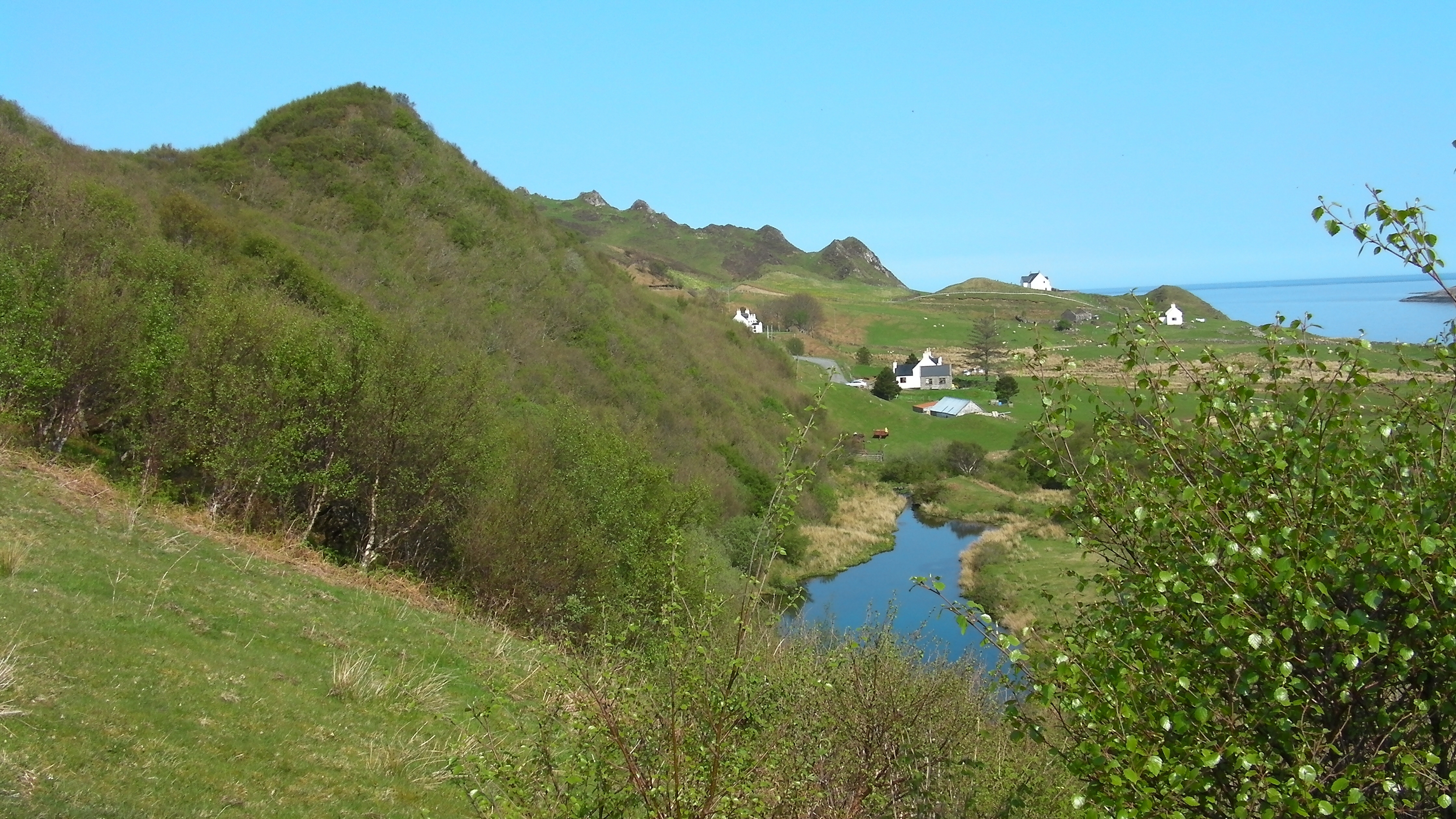
Overview
Directions
- From Portree, follow the A855 north to Staffin, then continue through Digg towards Flodigarry and Duntulm. The approach used for this guide is the Loch Shianta, or Healing Well, path on the seaward side of the road, north of Digg.
- The original guide records a small parking area beside the gate at the path entrance. Check the present signs before leaving your vehicle, as its availability and free-parking status have not been confirmed. Keep the gate, road and passing places clear.
- Follow the established downhill path towards Loch Shianta and the Healing Well, then the shoreward path through the hazel woodland to the Lower Dunans beach. The walk back is uphill. Keep to the path through the common grazing and follow any livestock or temporary access notices. The well is recorded at approximately NG 471 699; the fossil-bearing Lower Dunans shore lies to its east, around NG 473 699.
- Original Dunans locality reference: 57.65335°N, 6.24479°W. This lies north of the Healing Well and is a general locality reference, not a verified parking or beach-access point. Use the named Loch Shianta path for the route described here.
Location photographs
Swipe to browse · Select a photograph to enlarge


Fossil Hunting
The principal collecting area is the Lower Dunans foreshore below Loch Shianta, around the low headlands numbered Points 3 and 4 in geological accounts. Its grey clay and shale patches are easily hidden by beach gravel, boulders and seaweed. Conditions change as the sea moves the loose cover, so a productive patch on one visit may be concealed on the next. Low spring tides give the best opportunity to inspect the lower shore; plan a short visit around the tide rather than trying to combine this beach with the separate Flodigarry section.
Begin with loose, freshly weathered shale at the foot of the low exposure and with small pieces already detached on the foreshore. Look closely at natural split surfaces for coiled outlines, ribs and shell fragments. An ammonite may be represented by a thin impression rather than a solid shell, and an apparently unpromising flake can preserve part of the coil. Leave fossils that are still firmly attached to bedrock; prising them out can destroy both the specimen and its useful position in the succession.
Cardioceras is the characteristic ammonite of the Lower Oxfordian beds. The ribbing bends forwards towards the outer edge of the shell, where a keel can be visible on better-preserved material. Compaction commonly flattens the shells, so a fragment with clear ribs may be more informative than a worn, incomplete coil. Preservation varies between beds: some specimens retain shell material and some have greater relief.
The harder silty mudstone of Bed SS19 and the lowest part of SS20 have particular scientific importance. Thirty-one ammonites from these Lower Dunans beds formed the material for a detailed study of Cardioceras costicardia. Differences in rib strength, tubercles and shell shape within that assemblage were interpreted largely as variation within one species. This is a good reason to record where a find came from and to avoid assigning a species from a small fragment alone. The robust ammonite Goliathiceras is also documented from the Dunans Clay at Point 4, although the precise horizon of the published specimen was uncertain.
Belemnites are another recognisable find. Their solid internal guards usually appear as tapering, cylindrical pieces, sometimes with only a broken cross-section exposed. Many are incomplete or cracked, and the surrounding clay may be supporting fragments that would otherwise fall apart. Keep associated pieces together and support a loose specimen in a small padded container rather than pulling at an exposed end. A belemnite found loose among the stones cannot automatically be assigned to the older Belemnite Sands Member: belemnites also occur in the overlying shales.
Bivalves occur with the cephalopods. The Point 3 records include Pleuromya and small Nuculana, as well as other shell forms in different horizons. Look for paired curved valves, growth lines and impressions on weathered mudstone. Dark plant debris and branching burrows are also worth noticing. The burrows record animals working through the Jurassic sea-floor sediment, rather than later cracks in the rock.
The reddish nodules and harder ribs are useful geological markers, but they are part of the protected exposure. Where collecting is authorised, collect sparingly from loose material and photograph important specimens before moving them. Record the date, precise position, whether the find was loose or in place, and any confidently identified bed. Do not invent a bed number for a beach find. Report an unusual or potentially important discovery and seek advice before attempting any recovery that would disturb the rock.
Fossil photographs
Swipe to browse · Select a photograph to enlarge

Discoveries and milestones
A chronological record of geological research and fossil discoveries associated with the Lower Dunans shore.
1851 – Early recognition of the marine clay succession
Edward Forbes described ammonites and belemnites in beds above the older Staffin strata and recognised their relationship to the English Oxford Clay. Later geological work placed his section close to the modern Point 3 exposure at Lower Dunans.
1936–1937 – Detailed Geological Survey fieldwork
Survey work mapped the disturbed northern Skye coast and recorded the fossil-bearing shore and small cliff at Point 3. Its account, published in 1966, documented the shale beds, cementstones, faults and intrusions that remain important for understanding the Lower Dunans exposure.
1975 – Dunans Clay Member established
The marine succession was formally revised and the Dunans Clay Member was defined with its type section on the foreshore between Points 3 and 4. This gave the fossil-bearing clay a locality-based name and a place within the Staffin Shale Formation.
1979 – A numbered reference succession
The Dunans Clay type section was incorporated into a detailed, correlated log of the Staffin Shale Formation. Individual clay intervals and concretion bands were numbered, providing the SS-bed framework still used to locate ammonite horizons in later research.
2000 – Sedimentary cycles interpreted at Point 3
Detailed sedimentological work described the small-scale cycles within the mudrocks. Closely spaced cycles in the Praecordatum interval and more widely spaced cycles in the Costicardia interval at Point 3 were used to investigate changes in sediment accumulation and relative sea level.
2010 – Lower Dunans section recorded again
A new field log documented the exposed shale and nodule-bearing intervals at Lower Dunans, including the resistant SS19 marker and the lower part of SS20. It also recorded how gravel and seaweed cover affected the visibility of the shore.
2012 – Lower Dunans ammonites reshape species interpretation
A study based on 31 ammonites from SS19 and the lowest 3 m of SS20 interpreted much of their varied shape and ornament as variation within Cardioceras costicardia. The study introduced Cardioceras costicardia var. dunansi, and the studied material was deposited in Oxford University Museum. Goliathiceras was retained as a separate genus.
Geology
The fossiliferous rocks at Lower Dunans belong principally to the Staffin Shale Formation. The most characteristic exposure is the Dunans Clay Member, whose type section lies on the foreshore between Points 3 and 4, near NG 473 699. This member spans the late Callovian and early Oxfordian, crossing the Middle–Late Jurassic boundary. The familiar ammonite-bearing beds higher in it are Lower Oxfordian. “Oxford Clay” is an older name used in accounts of this coast; the current local lithostratigraphic name is Staffin Shale Formation.
These rocks accumulated in a marine basin. Fine sediment settled on the sea floor, while ammonites and belemnites lived in the water above it and bivalves occupied the bottom. Much of the Dunans Clay was disturbed by burrowing animals, producing mottled, poorly laminated mudstone. Thin darker, silty layers contain plant debris carried into the sea. Harder calcareous layers and iron-rich nodules interrupt the soft mudrock and now stand out as ribs or isolated rounded masses on the weathered platform.
The repeated changes within the mudstone are more subtle than the broad formation names suggest. Sedimentological work describes cycles from less than 10 cm to about 1 m thick in the Dunans Clay and Glashvin Silt. A cycle commonly begins with a thin, dark, plant-rich silty layer and passes upwards into paler calcareous mudstone, although some lack the dark basal layer. Their changing spacing has been used to interpret changes in sediment accumulation and relative sea level. These cycles are not the same thing as the larger numbered beds used to correlate fossil horizons.
The underlying Callovian succession can be reached in the lower foreshore when exposure and tide permit. The Belemnite Sands Member of the Staffin Bay Formation contains harder calcareous sandstones and siltstones. It is abruptly overlain by the darker, locally bituminous Dunans Shale Member, then by the paler Dunans Clay. At Point 3, the adjoining low cliff also exposes higher, siltier beds of the Glashvin Silt Member. Thus the beach contains several parts of a succession, rather than one uniform clay layer of a single numerical age.
The outcrops have also been changed long after deposition. Dolerite intrusions locally baked the sediment, and faulting and landslip movement disrupted the coastal succession. Lower Dunans includes gently dipping beds, contrasting with the steeply tilted exposures farther north. Beach stones and seaweed conceal contacts, while harder beds survive erosion better than the surrounding clay. A walk along the shore therefore does not pass through a simple, uninterrupted sequence, and published thicknesses must not be mistaken for the height of the little cliff.
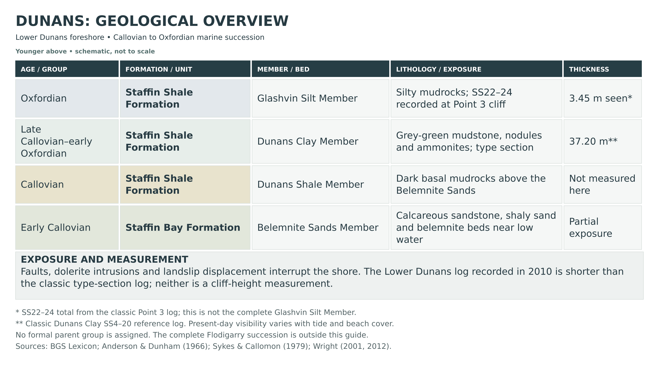
Detailed geology and bed-by-bed succession
Detailed geology and stratigraphy of the Lower Dunans foreshore and adjoining Point 3 exposure.
This account centres on the shore reached from Loch Shianta, especially the Dunans Clay type section near NG 473 699 between the numbered Points 3 and 4. The numbered beds below follow the classic published logs; they are measured stratigraphic thicknesses, not promises of what will be visible on a particular tide. The Staffin Shale section was assembled from overlapping, disturbed exposures. Neither the complete Staffin–Flodigarry succession nor its total thickness is exposed at this small beach.
The sedimentary units are described from older to younger. No formal group is assigned here: the BGS lists both the Staffin Bay Formation and Staffin Shale Formation without a parent group. In particular, these marine beds should not be labelled as the Lias Group.
Staffin Bay Formation
Early Callovian marine strata underlie the Staffin Shale Formation. At Lower Dunans, the useful local record is the Belemnite Sands exposure near low water at Point 3. The complete Staffin Bay Formation type section and its Upper Ostrea Member are at Point 5 farther north; their full measured succession is not transferred to this beach.
Belemnite Sands Member
The Point 3 memoir log records the following six beds, upward from its base. These are Anderson and Dunham’s local numbers, not the later SS numbers of the Staffin Shale Formation. Metric equivalents are rounded from the original feet and inches. Some historical fossil identifications are retained at genus level.
Local Bed 1: streaky shale, about 3.05 m
Grey-green shale with oysters and Pleuromya forms the lowest unit in the recorded Belemnite Sands section.
Local Bed 2: calcareous sandstone, about 0.76 m
A hard sandstone containing Pleuromya and other bivalves overlies the shale.
Local Bed 3: shaly sand, about 1.22 m
Grey-green, streaked sandy sediment contains Pleuromya. Its relatively soft, shaly character contrasts with the harder beds above and below.
Local Bed 4: pebbly calcareous bed, about 0.15 m
A hard, nodular, pebbly horizon contains belemnites.
Local Bed 5: green shale, about 0.46 m
Dark green shale with belemnites separates the two upper hard horizons.
Local Bed 6: upper calcareous bed, about 0.23 m
A sandy, concretionary, belemnite-bearing bed weathers red. Above this member the sediment changes sharply to the finer mudrocks of the Staffin Shale Formation.
Staffin Shale Formation
This formation contains marine mudstone, siltstone and subordinate sandstone. Its regional range extends from the middle Callovian into the Kimmeridgian, but only the lower and middle parts relevant to Lower Dunans are described here. Older accounts used “Oxford Clay” and “Corallian” for parts of the succession; those names must not be read as additional formations beneath or above the modern units.
Dunans Shale Member
The basal member is Callovian and lies between the Belemnite Sands and Dunans Clay members. Dark, bituminous mudrock with belemnites occurs at the base of the local Point 3 shale succession. The older memoir included it in a roughly 7.3 m shale interval below the prominent paired cementstones; that entire interval is not a secure measurement of this member alone. The separately measured SS1–SS3 type section is at Point 5, about 1 km north, so its bed thicknesses are not used as measurements of the Lower Dunans exposure.
Dunans Clay Member
The Dunans Clay type section is the foreshore midway between Points 3 and 4. It comprises pale grey-green silty mudstone with carbonate and iron-bearing concretions. The classic SS4–SS20 log totals 37.20 m and spans the late Callovian Athleta and Lamberti zones and the early Oxfordian Mariae and Cordatum zones. The following individual descriptions retain that published reference scheme. The short section logged at Lower Dunans in 2010 is described separately below; its exposed thicknesses should not be substituted silently into the older complete log.
SS4: basal silts and silty clays, 1.90 m
Pale grey-green sediment rests above the darker shale facies. Chondrites burrows mark the base; several levels contain abundant Bositra, and rows of phosphatic nodules occur within the bed. Kosmoceras phaeinum and Kosmoceras cf. rowlstonense place it in the Phaeinum Subzone of the late Callovian Athleta Zone.
SS5a: lower cementstone, 0.25 m
Carbonate cement has hardened the siltstone into the lower of two conspicuous marker beds.
SS5b: intervening silty clay, 0.45 m
Softer silty sediment separates the two cementstones.
SS5c: upper cementstone, 0.25 m
The second carbonate-cemented siltstone completes the paired marker. Bositra is common throughout SS5a–c, with Kosmoceras and Quenstedtoceras recorded from both SS5b and SS5c. Ammonites place the interval in the Henrici Subzone of the Lamberti Zone. The 1979 reference log associates SS5c with the holotype of Kosmoceras degradatum (IGS 30450) and additional specimens from the type locality; this historical bed attribution does not by itself establish an exact Lower Dunans collecting point.
SS6: burrowed silty clay, 2.55 m
Grey-green clay contains lignitic plant debris and phosphatic nodules, with abundant disturbance by Thalassinoides and Chondrites. Bositra is confined to the base; scattered small bivalves, belemnites and ammonites occur above. In the classic log, the first Scarburgense Subzone ammonites occur 2.20 m above its base, placing the Callovian–Oxfordian boundary within the bed.
SS7: concretion horizon, 0.20 m
A row of calcareous, slightly sideritic concretions weathers reddish. These harder nodules interrupt the soft clay.
SS8: clay, 5.50 m
Mudstone similar to SS6 contains Quenstedtoceras mariae, Q. omphaloides and Cardioceras scarburgense below, with the Praecordatum Subzone recorded from 3.60 m above the base in the classic scheme. A published Longaeviceras staffinense horizon is placed 2 m above the base. These are reference-log correlations, not identifications that can be applied to loose beach specimens.
SS9: concretion horizon, 0.20 m
A further reddish-weathering, calcareous and slightly sideritic nodule band separates SS8 from SS10.
SS10: silty clay, 1.40 m
Soft silty clay resumes between the SS9 and SS11 nodule bands.
SS11: concretion horizon, 0.20 m
A thin row of concretions, similar to SS7, provides another marker within the mudstone.
SS12: silty clay, 2.30 m
The classic log places the beginning of the Bukowskii Subzone of the Cordatum Zone 0.80 m above the base. Published correlations of this part of the section differ, so the bed number and the fossil identification should both be recorded when interpreting a collected specimen.
SS13: concretion horizon, 0.25 m
Calcareous, slightly sideritic nodules form a somewhat thicker marker band above SS12.
SS14: silty clay, 2.70 m
A thicker interval of relatively soft mudstone separates the SS13 and SS15 concretion rows.
SS15: concretion horizon, 0.20 m
Another thin, reddish-weathering nodule band interrupts the silty clay.
SS16: silty clay, 0.90 m
A comparatively short mudstone interval lies between the SS15 and SS17 marker horizons.
SS17: concretion horizon, 0.20 m
The last of this run of thin concretion bands underlies the thicker SS18 shale.
SS18: silty clay, 3.90 m
The classic log records a thicker clay interval beneath the SS19 marker. The later Lower Dunans description measured approximately 4.0 m and noted thin, darker, resistant shale ribs at roughly half-metre intervals. This interval belongs to the Bukowskii Subzone in the local 2010 account. The 1979 reference log emphasises uncertainty in matching SS12–SS18 to Turner’s earlier beds because the Praecordatum–Bukowskii boundary had been placed differently. It records characteristic Cardioceras (Korythoceras) and associates the type of Korythoceras korys with that interval. The historical type specimen has only broad Loch Staffin provenance, so it is not presented as a precisely located discovery on this beach.
SS19: resistant calcareous mudstone, 1.50 m
The harder silty mudstone forms a recognisable raised band on the wave-cut platform. The classic description divides it into two courses; the later Lower Dunans log notes a discontinuous buff nodule layer towards its top. Its Costicardia Subzone ammonites are central to the detailed study of Cardioceras costicardia.
SS20: upper silty clay, 12.35 m in the classic log
Soft mudstone succeeds the SS19 marker. At Lower Dunans, the 2010 exposure showed several metres of mottled shale with scattered buff nodules near its base. The lowest 3 m were assigned to the Costicardia Subzone. The older full log places the Cordatum Subzone from 9.40 m above the base; that level must not be assumed to be visible in the shorter modern exposure.
The separately recorded Lower Dunans exposure, 2010
Wright’s local log groups SS7–SS17 into 4.7 m of alternating harder and softer shale with iron-cemented layers and red-weathering nodules, followed by SS18, SS19 and the exposed lower part of SS20 described above. It assigns the grouped lower interval and SS18 to the Bukowskii Subzone. This does not reproduce the thickness or zonal limits of the older composite log. The two records are therefore kept distinct rather than combined into an apparently exact modern section.
Glashvin Silt Member
The passage out of the Dunans Clay is a change towards darker, more silty sediment. Lower Glashvin beds are recorded near Point 3, and the small cliff at Point 3 is a reference exposure for the upper part of the member. The full member extends into the Middle Oxfordian. Its complete thickness is assembled from more than one exposure and is not the thickness of this cliff.
SS21: lower silt interval
Dark silts with paler clay interbeds, woody material and occasional sandy layers form the lower part of the member. The local Point 3 area includes ammonites of the Vertebrale Subzone. The classic reference description also notes several cream-coloured ash bands; these are coastal reference-log features, not individually verified ash layers on the guide beach. The 12.35 m classic measurement is principally from the exposure south of Point 5, so no equivalent local thickness is claimed here. A gap in exposure separates the upper part of this interval from SS22 in the reference succession.
SS22: upper dark silts, 2.55 m seen at Point 3
Dark grey silt with subordinate lighter clay contains Cardioceras (Miticardioceras) tenuiserratum, indicating the Tenuiserratum Subzone. The stated thickness is the recorded exposure, not evidence that the underlying gap is absent.
SS23: fine sandstone marker, 0.10 m
A thin, very fine-grained silty sandstone makes a recognisable band within the Point 3 cliff.
SS24: silt and clay, 0.80 m
Dark silt alternates with paler clay above the sandstone marker. The next numbered bed, SS25, has its main reference exposure between Points 4 and 5, outside the small Lower Dunans section described here.
Sedimentary cycles and concretions
The Dunans Clay and Glashvin Silt contain repeated centimetre- to decimetre-scale changes in silt and carbonate content, with cycles ranging from less than 10 cm to about 1 m. Some start with a thin, plant-rich silty layer, followed by progressively paler calcareous mudstone. Burrows include Thalassinoides, Planolites and Chondrites; some cycle bases contain small scours and shell debris. Siderite and calcite nodules are products of cementation within the sediment, and septarian cracks record subsequent internal fracturing. At Point 3, changes in cycle spacing have been interpreted in terms of relative sea-level changes; the cycles are not individually named formal beds.
Faults, intrusions and modern exposure
The Point 3 memoir describes a fault repeating part of the shale succession and locally hardened shale alongside a small dolerite sill; another dyke and fault interrupt the beds immediately south. Further intrusions occur near Point 4. These structures, together with landslip displacement, explain why strata are repeated or juxtaposed rather than arranged as one continuous cliff. Beach gravel, boulders and seaweed are modern cover and are not additional members of the Jurassic succession.
References
Anderson, F. W. and Dunham, K. C. (1966). The geology of northern Skye, Chapter 4. Memoir of the Geological Survey of Great Britain (Scotland). Point 3 measured section and structural observations.
British Geological Survey. Lexicon entries for the Staffin Bay Formation, Belemnite Sands Member, Staffin Shale Formation, Dunans Shale Member and Dunans Clay Member.
Sykes, R. M. (1975). The stratigraphy of the Callovian and Oxfordian stages (Middle–Upper Jurassic) in northern Scotland. Scottish Journal of Geology, 11, 51–78. Formal member definitions; see also the BGS Lexicon.
Sykes, R. M. and Callomon, J. H. (1979). The Amoeboceras zonation of the Boreal Upper Oxfordian. Palaeontology, 22, 839–903; type-section descriptions on pp. 896–898.
Morton, N. and Hudson, J. D. (1995). Field guide to the Jurassic of the Isles of Raasay and Skye, Inner Hebrides, NW Scotland. In Taylor, P. D. (ed.), Field Geology of the British Jurassic, 209–280. Locality framework and revised sections, also summarised in the Geological Conservation Review.
Cox, B. M., Page, K. N. and Morton, N. (2002). The Middle Jurassic stratigraphy of Scotland. In Cox, B. M. and Sumbler, M. G., British Middle Jurassic Stratigraphy, Geological Conservation Review Series 26. Staffin measured section, p. 406.
Wright, J. K. (2001). Staffin. In Wright, J. K. and Cox, B. M., British Upper Jurassic Stratigraphy (Oxfordian to Kimmeridgian), Geological Conservation Review Series 21, 201–210.
Hesselbo, S. P. and Coe, A. L. (2000). Jurassic sequences of the Hebrides Basin, Isle of Skye, Scotland. In Graham, J. R. and Ryan, A. (eds), International Association of Sedimentologists, Dublin: Field Trip Guidebook, 41–58. Sedimentary cycles and Point 3 observations.
Wright, J. K. (2012). Speciation in the cardioceratinid ammonites of the Costicardia Subzone (Cordatum Zone) of the Oxfordian of Skye. Scottish Journal of Geology, 48, 61–72. DOI: 10.1144/0036-9276/01-441.
Safety
Plan the shore visit around low tide and a calm sea. Much of the useful foreshore is submerged as the tide rises. Check local tide times and the weather beforehand, keep the return to the access path in view and leave plenty of time to get back. Do not continue around coastal projections if the tide or waves could block your return, and avoid the shore in rough weather.
The rounded boulders, seaweed and wet clay can be very slippery, while loose stones may move underfoot. Wear sturdy footwear with good grip, move carefully between the boulders and supervise children closely. Stay clear of the eroding banks and any overhangs; do not climb or dig into the soft exposures. The downhill approach can be muddy and requires an uphill return.
The Loch Shianta path crosses common grazing where the community visitor leaflet specifically warns of cattle with calves. Give animals plenty of space and follow an appropriate alternative route if needed. Do not take a dog into fields containing calves or other young livestock. Leave gates as found.
Carry a charged phone, weatherproof clothing and a means of identifying your position, and tell someone your plans. Do not depend on a mobile signal being available throughout the visit. In an emergency on the coast, call 999 or 112 and ask for the Coastguard.
Equipment
Wear sturdy footwear with a good grip and bring waterproofs, a charged phone, a map and current tide information. A camera, hand lens and small scale are useful for recording ammonites and belemnites without disturbing the exposure. Mobile reception cannot be relied upon along the shore.
Where collecting permission has been obtained, take padded rigid boxes and labels rather than packing fragile mudstone fossils loosely in a bag. Leave heavy tools behind: this soft, protected succession is best examined through naturally weathered material, without levering fossils from the bedrock or cutting the low face.
Cleaning And Treating
For specimens already lawfully collected, support soft clay or shale on a firm base and begin with gentle dry brushing. Do not try to wash a flattened ammonite free of its matrix: soaking can break down the mudrock and destroy the impression. Keep broken belemnite pieces together and labelled, rather than attempting a hurried repair on the beach.
If a specimen is pyritised, it needs particular care. Store it dry, avoid prolonged damp conditions and watch for powdering, cracking or a sulphurous smell. Do not routinely soak pyritic fossils, use acids or bleach, or coat them with household varnish. Leave delicate or potentially important specimens unprepared until a museum or experienced conservator can advise; retain the exact locality and bed information whenever it is known.
Identify Your Finds
Need help identifying a fossil? Share clear photos, where you found it and its size with the community.
Further Reading
Deposits Magazine: Staffin Museum and its Skye fossil collections
BGS Lexicon: Dunans Clay Member
Geological Survey memoir: the fossiliferous shales and Point 3 section
Geological Conservation Review: Staffin coastal sections
Sykes and Callomon: numbered reference section of the Staffin Shale
Wright: the Lower Dunans ammonites and their variation
Icon / NatSCA: care and conservation of geological specimens
Access Rights
The Lower Dunans shore beside Loch Shianta is part of Trotternish Ridge Site of Special Scientific Interest (SSSI). Its Jurassic rocks are protected geological features. Check the NatureScot site record and boundary information before visiting.
Responsible pedestrian access under the Scottish Outdoor Access Code does not give a right to extract or remove fossils. Obtain the landowner’s permission to collect and retain specimens, and establish any additional consent requirements before collecting. Follow the Scottish Fossil Code and Guidance; absence of a sign prohibiting collecting is not permission.
The SSSI management statement states that amateur collecting is unlikely to be damaging when it concentrates on loose material and significant finds are reported, while warning against damaging extraction. Where collecting is authorised, restrict ordinary collecting to small, naturally loose specimens. Do not hammer, chisel, scrape or dig fossils from the cliff or foreshore bedrock without the necessary landowner permission and NatureScot consent. Soft clay that remains in place is still bedrock.
The Skye Nature Conservation Order 2019 protects vertebrate fossils at specified parts of the island. Its mapped areas do not include this Lower Dunans beach; the SSSI safeguards and fossil-ownership requirements still apply. If you find possible bone, a footprint or an unusual associated skeleton, leave it undisturbed, photograph it, record its position and follow NatureScot’s guidance on recording and reporting significant finds.
It is important to follow our Code of Conduct when collecting fossils or visiting any site. Please also read our Terms and Conditions.
Links
♦ Fossil Discussions
♦ Fossil Articles
♦ Buy Fossils, Tools and Equipment
♦ Buy Crystals, Meteorites, and Artefacts
♦ Join Fossil Hunts
♦ UK Fossils Network


