
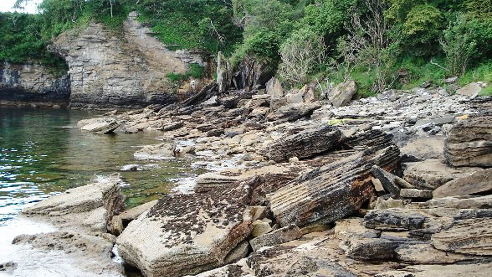
Overview
Directions
- From Elgol, take the minor road east to Glasnakille rather than continuing on the B8083. The three approaches below retain the numbering used in the original location photographs. They are historical route descriptions, not a recent survey of paths or parking. The bays cannot be linked by assuming a continuous low-tide shore route: the sea reaches the intervening cliffs even at low water.
- Location 1, northern approach: turn left at the Glasnakille junction and follow the road towards its end. The original guide continued on foot through a gate and along a wooded path, passing further gates and reaching a house after about 600 m, then descending on the path just beyond it. Respect residents’ privacy and use the established route, where clear; overgrowth and present path conditions may differ from the photographs.
- Location 2, middle approach: the original route used a telephone box and nearby lay-by as landmarks, crossed a stile and followed a fence before turning south through bracken towards a sloping gap in the cliffs. The survival of those landmarks and the condition of this steep descent have not been verified. Bracken can hide broken ground and drops; do not search for a route at the cliff edge, and turn back if the way down is unclear.
- Location 3, southern approach: the original guide followed the road in the opposite direction from Location 1, continuing on foot where it became a path to the beach. This was described as the easier approach, but the shore remains rough and tidal. It should not be treated as suitable for every visitor or every condition.
- Parking: the original verge, lay-by and road-end suggestions are not verified public parking facilities or permission to park. Follow current signs and keep turning heads, passing places, gates, private drives and agricultural access clear. If there is no lawful, unobstructive space, park elsewhere rather than squeezing onto a verge.
- Locality reference: 57.14802° N, 6.07024° W is the original guide’s reference, not a verified parking pin or safe descent. Carry a suitable map and check your actual approach. The separate Spar Cave walk involves tidal scrambling and must not be substituted for these fossil-bay routes.
Location photographs
Swipe to browse · Select a photograph to enlarge


Fossil Hunting
Belemnites are the main fossils to look for at Glasnakille, with occasional bivalves in the same hard rocks. Most finds are sections or broken pieces rather than complete, easily removed specimens. The existing locality record describes fossils in foreshore pebbles and cobbles, larger boulders, rock platforms and cliff exposures; there is no single reliably productive patch among the three beaches.
Examine the naturally exposed faces of loose stones before considering any collecting. A belemnite seen lengthways may appear as a straight or tapering solid fossil; a cut across it can show a rounded section with radiating calcite fibres and sometimes concentric growth bands. These are parts of the rostrum, the internal hard structure of a squid-like marine animal. Look at the sides as well as the upper surfaces of cobbles, since the direction in which a fossil meets the rock surface changes its appearance.
Bivalves are less conspicuous here and may survive as shell fragments or curved shell sections within the sandy matrix. A hand lens helps separate recognisable shell material from the surrounding grains. The member also contains crinoid, bryozoan and brachiopod debris regionally, but that broader fossil list should not be taken as a promise of identifiable specimens on every Glasnakille beach. No securely verified species list is available for the individual collecting spots, so retain cautious identifications rather than assigning names from other Skye sites.
Search slowly across weathered, safely accessible material and photograph fossils that are firmly embedded in large blocks or bedrock. Include a scale and record which beach the find came from, whether it was loose or in place, and the surrounding rock. Keeping that context is especially valuable on a coast where the sandstone changes laterally and loose material cannot automatically be assigned to a particular bed. Follow the collecting restrictions and Scottish Fossil Code below before removing anything.
Fossil photographs
Swipe to browse · Select a photograph to enlarge


Discoveries and milestones
A chronological record of geological research and sedimentological discoveries at Glasnakille.
1965 – Southern Strathaird succession documented
Nicol Morton’s study established the pronounced thickness and lithological changes in the Bearreraig sandstones of Strathaird. The very thick southern succession, subsequently cited at about 488 m at Glasnakille, provided an important basis for understanding how sediment accumulated unevenly within the basin.
1996 – Large tidal dunes described
Donatella Mellere and Ronald Steel documented Glasnakille’s cross-bedded sandstones, including an approximately 8 m-thick dune set with smaller opposing bedforms and fine sediment drapes. These structures supplied detailed evidence of reversing tidal currents and interruptions in dune migration.
2019 – Fault-controlled tidal seaway investigated
Stuart Archer and colleagues incorporated the Glasnakille section into a study of how moving and tilting fault blocks influenced Middle Jurassic sedimentation. The work linked differences in sandstone thickness and sedimentary environments to the shape and development of the Hebridean basins.
2025 – Internal structure of tidal bars analysed
Sicheng Zhu and colleagues examined two approximately perpendicular outcrop sections at Glasnakille. Their analysis traced the arrangement of lamination and successive dune scales within tidal bars, including erosion between bar bodies about 4–5 m thick, helping explain how changing currents built the sandstone succession.
Geology
The fossil-bearing cliffs and shores at Glasnakille expose the Druim An Fhurain Sandstone Member of the Bearreraig Sandstone Formation. Calcareous sandstone and sandy limestone alternate, commonly showing inclined layers within larger beds. The BGS gives the member a broad Toarcian–Bajocian range; this is the range of the unit, not a precise age determination for each fossil-bearing rock on the beach. The formation has no assigned parent group and should not be placed in the Great Estuarine Group.
The inclined layers are cross-bedding, produced as underwater sand bedforms migrated. Glasnakille has been used in studies of tidal sedimentation because its exposures preserve both large dunes and smaller structures recording changes in current direction. Repeated movement of sand under strong tidal currents helps explain why marine fossils commonly occur as fragments mixed into the sediment rather than as intact shells. Belemnites and bivalves confirm the marine character of the local fossil assemblage.
The coastal rocks formed within the fault-controlled Hebridean basin system. The Glasnakille succession lies south of the Camasunary Fault, where a restricted seaway concentrated tidal flow. The formation thickens markedly southwards through Strathaird, reaching a published estimate of about 488 m at Glasnakille. That figure describes the geological succession, not the height of the cliffs or a thickness that can be walked continuously along one beach.
The larger sedimentary structures are often easier to appreciate than the fossils themselves. Stand back from a safe viewpoint to compare the direction of inclined layers between adjacent sets, then examine loose weathered material for shell sections. These outcrops are parts of a laterally variable sandstone succession: they should not be treated as a complete exposure of every formation or fossil bed described from nearby Elgol.
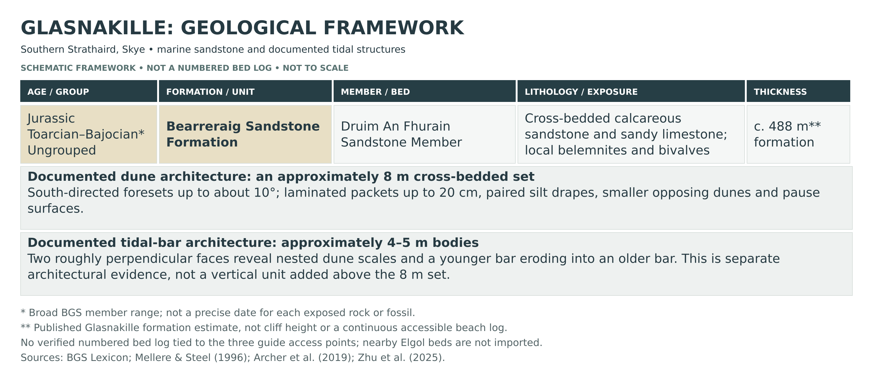
Detailed geology and bed-by-bed succession
Explore the sandstone succession, fossil-bearing rocks and tidal structures recorded at Glasnakille.
BEARRERAIG SANDSTONE FORMATION
This marine Jurassic formation is ungrouped. Its regional age extends from the Toarcian to the Bajocian, and its thickness and rock types vary considerably across Skye and Raasay. A thickness of approximately 488 m is reported at Glasnakille in southern Strathaird. Measurements differ between studies because of lateral changes and the difficulty of combining discontinuous cliff sections; this is not a single accessible measured beach section.
DRUIM AN FHURAIN SANDSTONE MEMBER
The member comprises cross-bedded sandstone and sandy limestone, with both thick, relatively structureless intervals and thinner bedding. Its shell debris includes crinoid ossicles, bivalves, bryozoans, belemnites and brachiopods, especially in the lower succession regionally. Belemnites and bivalves are specifically recorded on the Glasnakille shore. The spelling Druim an Fhuarain also occurs in the literature; Raasay Sandstone Member is an obsolete name used in the BGS synonymy.
Medium-scale cross-bedded sandstone sets. Published photographs from Glasnakille show predominantly tabular, planar-bounded sets, with wedge-shaped sets in some intervals. These preserve the internal layering of migrating underwater dunes rather than separate formally named beds.
Very large dune set, approximately 8 m thick. One documented Glasnakille exposure has southward-inclined foresets, dipping up to about 10°, above trough cross-bedding. Internal laminated packets reach about 20 cm and are separated by paired siltstone drapes. Smaller dunes moving in the opposite, flood-tide direction occur near the top. Pause surfaces carry dunes oriented towards the south-west or west. Above the main ebb-directed set, alternating ebb- and flood-directed bedforms are followed by larger ebb-directed dunes. This is the sequence within the illustrated exposure, not a bed-numbering scheme for the entire coast.
Tidal-bar bodies, approximately 4–5 m thick. Zhu and colleagues examined two roughly perpendicular Glasnakille faces, distinguishing five architectural levels. Level 0 consists of centimetre-scale laminae, commonly obscured by weathering. Level 1 comprises single dunes whose inclined layers locally change to parallel or trough-shaped arrangements. Level 2 comprises complex dunes: about 20 cm thick and metre-scale laterally across the former current, reaching 5 m laterally in the along-current face. Level 3 comprises compound dunes; their boundaries truncate level 2, remaining roughly parallel across-current but meeting at larger angles along-current. Levels 0–3 build level-4 tidal bars about 4–5 m thick. In the along-current face, a younger bar cuts into an older one along a concave erosion surface, interpreted as evidence of lateral channel and bar migration. These are sedimentary architectural levels, not formal members or numbered stratigraphic beds, and their relationship to the separately illustrated 8 m dune set has not been established here.
Limits of the exposed succession. Available descriptions establish detailed sedimentary structures but do not provide a verified numbered bed-by-bed log tied to the guide’s three access points. The basal limestone described elsewhere in Strathaird, and the topmost crinoidal limestone and overlying mudstones described south of Elgol, are not presented here as exposed Glasnakille collecting horizons. Neither the named ammonites of other sections nor Skye’s dinosaur-bearing beds should be added to this local succession without site-specific evidence.
References
British Geological Survey. Bearreraig Sandstone Formation and Druim An Fhurain Sandstone Member, BGS Lexicon.
Mellere, D. and Steel, R. J. (1996). Tidal sedimentation in Inner Hebrides half grabens, Scotland: the Mid-Jurassic Bearreraig Sandstone Formation. Geological Society, London, Special Publications, 117, 49–79.
Archer, S. G., Steel, R. J., Mellere, D., Blackwood, S. and Cullen, B. (2019). Response of Middle Jurassic shallow-marine environments to syn-depositional block tilting: Isles of Skye and Raasay, NW Scotland. Scottish Journal of Geology, 55, 35–68.
Zhu, S. and colleagues (2025). Research on the sedimentary architecture characterization and genetic mechanisms of tide-dominated estuaries: case studies of M1 Sandstone in Oriente Basin and Bearreraig Sandstone in Hebrides Basin. Journal of Palaeogeography (Chinese Edition), 27(6), 1368–1399.
Safety
These are remote, rocky shores below cliffs, with steep or overgrown approaches at Locations 1 and 2. Bracken can conceal holes, loose ground and sudden drops. Keep away from unstable cliff edges and bases, and abandon any descent that is unclear or beyond your experience. The historically easier Location 3 is not a guarantee of safe access for children or visitors with limited mobility.
Check local tide predictions and weather before setting out, avoid rough seas, and return by your known land approach. Low tide does not open a continuous route between the bays. Do not round a headland on the assumption that you can get back, and do not apply the separate Spar Cave excursion’s tide window to this whole coastline.
Go with a companion, wear boots with good grip and take a map, waterproofs and a charged phone with offline information. Tell someone your route and expected return time; mobile reception may be unreliable. Wet rock, seaweed and loose boulders demand care even in calm weather.
Observation and photography are the safest starting point. Do not climb cliffs, undermine exposures or use a sledgehammer to force fossils out of hard rock. Any collecting requires appropriate permission; unusual or potentially important finds should be recorded and reported rather than extracted.
Equipment
Wear sturdy walking boots and carry waterproofs, warm layers, food and plenty of water for the full outward and return walk. Bring an offline map, compass, charged phone, tide information and a first-aid kit. A camera, hand lens and small scale are more useful for examining the exposures than heavy tools; mobile reception should not be relied upon.
If collecting has been agreed with the relevant owner or manager, carry labels, padding and small rigid boxes for permitted loose specimens. Record the precise find spot and whether the rock was loose or still in place. Leave heavy tools behind and do not take risks carrying large boulders up the shore paths.
Cleaning And Treating
For lawfully collected specimens, start with gentle dry brushing and keep the fossil supported by its matrix. Weathered shells and exposed belemnite sections can crack or detach if soaked or scrubbed. Allow wet material to dry slowly at room temperature and retain matching fragments together with the original locality label.
Hard sandstone or calcareous blocks may preserve shells as moulds or as fragile shell surfaces. Do not force matrix away with a chisel or use household acids, bleach or varnish: these can destroy the shell or obscure diagnostic detail. Limited mechanical preparation under magnification is preferable when the rock is stable. Leave unusual or potentially significant fossils unprepared and seek museum or specialist advice, retaining their find information.
Identify Your Finds
Need help identifying a fossil? Share clear photos, where you found it and its size with the community.
Further Reading
Skye: Island of Dreams — Deposits Magazine (island-wide background)
BGS: Druim An Fhurain Sandstone Member
BGS: Bearreraig Sandstone Formation
BGS: recognising and understanding belemnites
Tidal sedimentation in the Bearreraig Sandstone Formation
Tidal-bar architecture, including Glasnakille outcrops (Chinese text, English abstract)
Access Rights
Access and collecting are separate permissions. Responsible pedestrian access under Scotland’s access legislation does not give a right to extract or keep fossils. Follow the Scottish Fossil Code and Guidance, seek permission from the landowner or relevant mineral-rights owner before extracting, collecting or retaining specimens, and respect homes, gates, livestock and local signs. No current site-specific collecting permission has been verified for this guide. If permission is unclear, photograph the fossils and leave them in place.
Local protection check, 15 October 2026: NatureScot’s current SSSI, Nature Conservation Order and Geological Conservation Review mapping returned no intersection at the guide’s reference point or within the checked Glasnakille coastal envelope, 57.12–57.18° N and 6.09–6.03° W. Nearby Elgol Coast SSSI and the Skye Nature Conservation Order have a different mapped footprint; their presence elsewhere on Skye does not make Glasnakille part of them. This bounded map check does not establish ownership, collecting permission or the absence of every other designation. Check NatureScot SiteLink for your precise destination before visiting.
The Skye fossil-protection guidance remains important when visiting other parts of the island. In areas actually covered by the Skye NCO, vertebrate-fossil extraction and removal are restricted, including loose fragments, subject to specific scientific exemptions. SSSI requirements and owner permission must also be considered separately; a GCR entry is not interchangeable with either legal designation.
Record finds with photographs, a precise location and, where visible, their position in the rock succession. Leave unusual fossils, suspected bones and possible tracks undisturbed and seek specialist advice. The absence of a prohibition sign is not permission to collect, and the old recommendation to use large hammers should not be followed.
It is important to follow our Code of Conduct when collecting fossils or visiting any site. Please also read our Terms and Conditions.
Links
♦ Fossil Discussions
♦ Fossil Articles
♦ Buy Fossils, Tools and Equipment
♦ Buy Crystals, Meteorites, and Artefacts
♦ Join Fossil Hunts
♦ UK Fossils Network


