
Overview
Directions
- From Girvan, the original approach follows the B741 north-east, crossing the railway three times. Where the B741 turns right towards Dailly, the described route continues straight on the minor road, crosses the railway again, then takes the next left into the woods. Confirm that this remains the agreed approach with the landowner before travelling.
- The historic route starts at a gated woodland track about halfway along a straight section of road. The old guide suggested parking there, but the gate is not a confirmed parking place: use only the parking agreed for your visit and keep all access clear.
- The original walk follows the track past a large house on the left, then takes its northward course towards the pit. Allow for roughly 3 km on foot in the historic account. Current tracks, working areas and the correct quarry entrance need confirmation from the permission giver.
- Locality reference: 55.28789°N, 4.74909°W (approximately NS 25523 02752). This is the original guide point, not a newly surveyed quarry boundary or parking location.
Location photographs
Swipe to browse · Select a photograph to enlarge


Fossil Hunting
The 2008 visit describes fossil-bearing blue-grey to olive-green mudstone, with pale shells conspicuous on freshly exposed surfaces. Brachiopods and molluscs were prominent in the original account, while historic scientific descriptions of the classic Glenmard quarry record brachiopods, bivalves, gastropods and trilobites. These are useful groups to look for in authorised loose material, but the photographs and old abundance rating do not establish what is exposed today.
Begin with naturally weathered faces of loose blocks in the area agreed with the landowner. A hand lens and low, oblique light help reveal shell ribs, curved growth lines, coiled gastropods and segmented trilobite fragments. Brachiopods and bivalves can both resemble small paired shells; external shape alone is rarely enough for a confident identification. Retain photographs of both sides and any natural counterpart, with a scale and a record of the host rock.
The original visitor found that seemingly barren scree could contain shells inside the mudstone, and reported variable fossil concentrations, including productive material in the south-western part of the photographed pit. That is a 2008 observation rather than a direction to a currently accessible bed. Only split a limited amount of loose material if the visit conditions expressly allow it; do not cut into a face, pursue a seam or take bulk samples on the strength of the old account.

Some of the classic quarry deposits contain shells transported with mud during submarine mass movement. A dense cluster can therefore represent material concentrated by a flow rather than a community preserved where it lived. Keep a little surrounding matrix and record whether a find came from a loose block or an observed bed; do not assign a loose fossil to the Glenmard Conglomerate Bed or Glenmard Member simply because it was found in the wood.
A named trilobite record from the historic quarry is Achatella retardata, discussed from Quarrel Hill Formation mudstone in a 1995 study. This does not identify the specimens in the photographs. Published straight-shelled cephalopods from a separate Glenmard Wood point about 201 m east-north-east include Gorbyoceras gracile, but their source calls the rock Ladyburn Mudstone Formation. Keep that adjacent record separate from the 2008 pit and its unverified horizons. The original guide also mentions corals; no bed-specific coral identification is established here.

Fossil photographs
Swipe to browse · Select a photograph to enlarge


Discoveries and milestones
Significant discoveries, geological research and quarry history at Glenmard Wood and its immediate Quarrel Hill context.
1935 – Lamont distinguishes the Quarrel Hill fossil horizons
Archie Lamont’s lower-Drummuck revision distinguished mudstone and Crinoid Bed localities around Quarrel Hill, including the east brow and an exposure north-west of Glenlochrie. This established important context for the local succession; it does not document a visit to the later forestry quarry or the pit photographed in 2008.
Mid-1970s – An adjacent reference excavation reveals the Auldthorns base
A deep excavation at the base of the main Auldthorns scarp exposed the formation’s sharp basal contact on a typical Shalloch succession. This was an investigation of the Quarrel Hill reference scarp, not the Glenmard quarry or the pit photographed in 2008. The observed sharp boundary is not, by itself, evidence of an unconformity.
1977 – The classic forestry quarry section is lost
The original Glenmard forestry quarry was filled, graded and replanted. Its fossil-rich mudflows, shell-covered mud balls and disrupted calcareous blocks had provided evidence of downslope sediment transport. The loss explains why the classic section cannot be assumed to remain exposed, without implying that every later pit in the wood was closed.
1982 – Harper revises the Drummuck succession
David Harper’s stratigraphic revision provided the formation and member framework used in later accounts of the Glenmard deposits. Distinguishing the Glenmard Conglomerate Bed, Glenmard Member and Quarrel Hill Crinoid Bed gives the locality a more useful geological context than an undivided description as Ashgill mudstone.
1993 – Glenmard Wood cephalopods receive a published provenance
David Evans documented comparative specimens of Gorbyoceras gracile from a specified Glenmard Wood point. The location lies about 201 m east-north-east of this guide’s coordinate and was assigned to Ladyburn Mudstone Formation. The record supports local cephalopod interest but cannot be transferred silently into the Quarrel Hill quarry succession.
1995 – McCormick studies a Glenmard trilobite
Timothy McCormick discussed an unusual pygidium of Achatella retardata from Quarrel Hill Formation mudstone at Glenmard Quarry, as part of research on trilobite variation and stasis. This is a research date, not a recorded collection date; no particular named Glenmard bed was specified for the specimen.
2008 – A later quarry visit is documented
The original guide and its quarry photographs record a visit to a small roadstone pit in Glenmard Wood. They preserve useful observations of faces, scree and fossil-bearing mudstone after the loss of the classic quarry. The evidence does not establish that this was a reopening of the same excavation.
2013 – The Ayr synthesis retains the named Glenmard units
The British Geological Survey’s Ayr district synthesis retained the historic quarry’s fossiliferous conglomerate and mudflow deposits within the Quarrel Hill succession. Its account draws on earlier observations, including material recorded up to 2002; it is not a later inspection establishing the condition of the 2008 pit.
Geology
Glenmard’s classic fossil locality lies in the Quarrel Hill Formation, within the Drummuck Subgroup of the Ardmillan Group. These marine rocks are Late Ordovician: the regional Cautleyan interval of the Ashgill falls within the international Katian Stage. The older guide’s single numerical age should not be taken as a precise date for every fossil-bearing block. The modern hierarchy also avoids treating the historical name “Drummuck Group” as a separate unit above the subgroup.
The Quarrel Hill Formation is dominated by green mudstone, locally purple-stained, with silty layers, thin sandstone beds and conglomeratic deposits. Fine sediment accumulated between episodes that carried sand, pebbles and disrupted masses of sediment downslope. At the historic Glenmard quarry, shells arranged around mud balls and large broken calcareous blocks in slumped mud show that some fossil concentrations were transported. This explains why a richly shelly block need not represent animals living together on a stable sea floor.
The middle part of the formation contains the named Glenmard Conglomerate Bed and the mudflow-associated Glenmard Member. Both deserve recognition, but their exact mutual boundary and internal thicknesses are not established by the evidence available for this guide. Near the formation summit, the Quarrel Hill Crinoid Bed provides a separate reference horizon: its thin sandstone contains concentrated broken shell and crinoid material. Its published centimetre-scale detail comes from reference exposures around Quarrel Hill, not from a measured log of the 2008 pit.
The classic forestry quarry was backfilled in 1977, whereas the original UK Fossils photographs show a later roadstone-pit visit in 2008. Their precise relationship has not been demonstrated. The chart and expanded account therefore explain the historical and surrounding succession, with the photographed pit kept separate. Neither the old photographs nor a mapped point prove that all the named units are currently exposed.
Detailed geology and bed-by-bed succession
Detailed geology, named local horizons and fossil provenance for Glenmard Wood and the Quarrel Hill reference succession.
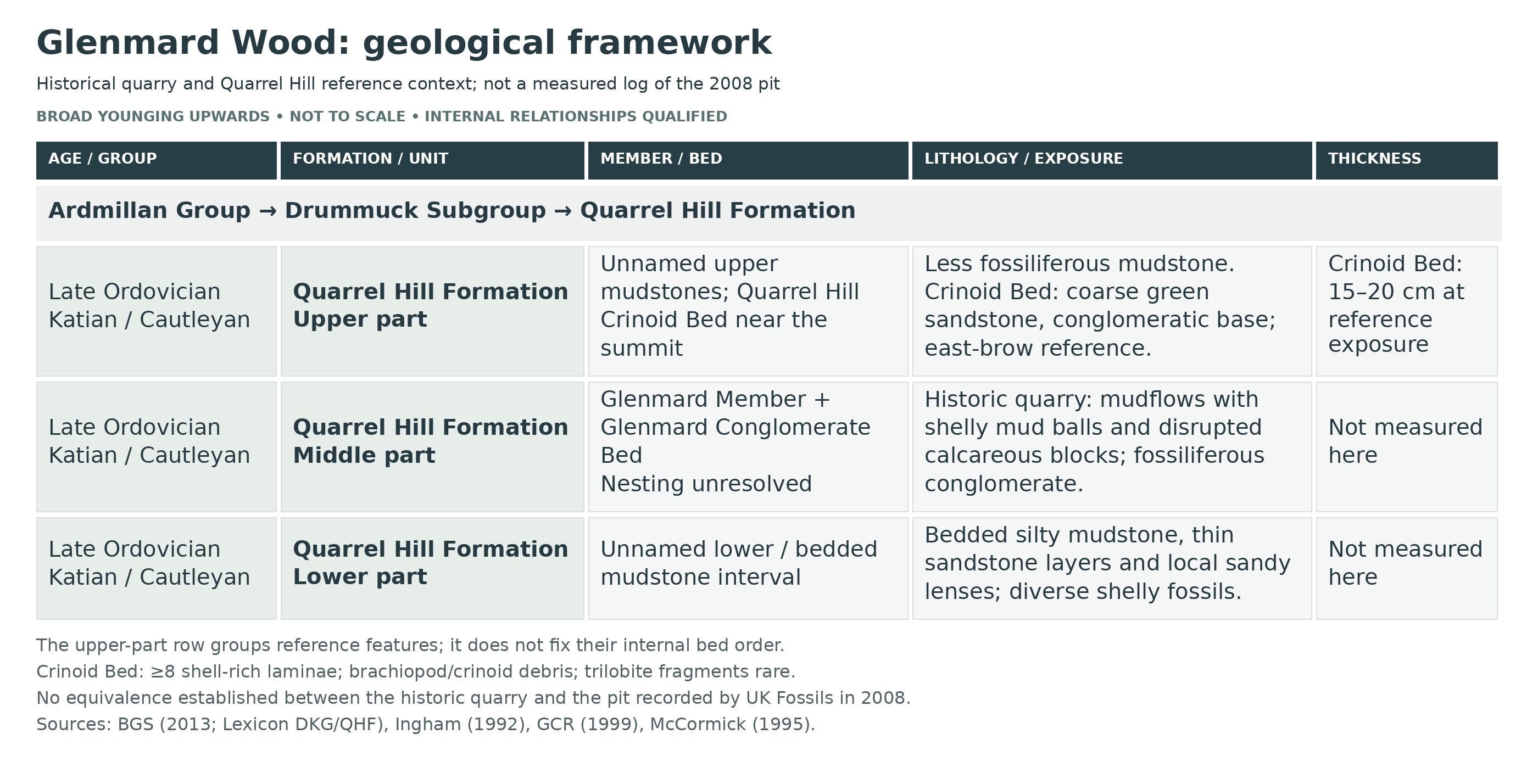
This is a contextual succession, not a continuous measured log of the pit photographed in 2008. The classic Glenmard quarry, the east-brow reference exposures and the separately located cephalopod material are distinguished below. Unknown thicknesses and unresolved correlations are left open rather than converted into a tidy quarry column.
ARDMILLAN GROUP
The supported regional parent of the Drummuck Subgroup. The local rocks record marine sedimentation and repeated sediment-gravity flows; later structure complicates the district’s outcrop pattern. A regional geological map cannot establish centimetre-scale beds in a quarry photograph.
DRUMMUCK SUBGROUP
Restricted to the Craighead Inlier in the current BGS framework. Its approximate 380 m thickness applies to the whole subgroup, not Glenmard quarry. Older publications use Drummuck Group; the 2013 Ayr account explains this rank change. The formation sequence is Auldthorns, Quarrel Hill, Lady Burn, South Threave and High Mains, from older to younger. Only the relevant lower succession is expanded here.
Auldthorns Formation — underlying regional context
This Cautleyan formation is approximately 35 m thick in the published Quarrel Hill context and underlies the Quarrel Hill Formation conformably. Its members are locally repeated by faulting near the nose of the Craighead anticline; this is surrounding outcrop structure, not a demonstrated fault or thickness in the photographed pit. A mid-1970s excavation at the main Auldthorns scarp exposed a sharp basal contact on the older Shalloch Formation; the sharpness alone does not establish an unconformity. Upwards, the succession changes from predominantly sandy Auldthorns sediment to the muddier Quarrel Hill deposits.
Escarpment Member
The lower Auldthorns division comprises greyish-green sandstone and conglomerate containing igneous clasts, followed by thickly bedded medium- to coarse-grained sandstone with shelly horizons. Broken brachiopods and trilobites occur in a few thin horizons. Its basal conglomerate is older than the Glenmard Conglomerate Bed and must not be given that younger name. These observations concern the Quarrel Hill reference outcrops; no thickness or named fossil bed is assigned to the 2008 pit.
East Brow Member
The upper Auldthorns division rapidly alternates greyish-green fine- to medium-grained sandstone and mudstone. It has virtually no conglomerate and more numerous, thicker mudstone beds than the Escarpment Member. Its fauna is less abundant and diverse, with strongly broken fossil debris in thin sandstone seams. This is a genuine surrounding stratigraphic unit, not an inferred exposed member at the guide point.
Quarrel Hill Formation
Cautleyan, within the Katian Stage of the Late Ordovician. The BGS formation-scale thickness is 115 m. Mainly green, locally purple-stained mudstone contains thinner sandstone interbeds, conglomerate and sediment-gravity-flow deposits with large transported blocks, or olistoliths. Its lower contact is a conformable shift from sandstone-dominant Auldthorns facies to mudstone-dominant sediment; its upper transition to pale-grey silty Lady Burn mudstone is conformable but poorly defined. The historic Glenmard quarry sampled the middle part.
Unnamed lower/bedded mudstone interval. Greyish-green bedded silty mudstone is locally fissile, with red-purple surface coating. Thin green sandstone layers, sandy lenses and rare thin “rottenstones” accompany it. This older background facies of the surrounding Quarrel Hill succession has an abundant, diverse fauna dominated by dalmanellid, chonetid, strophomenid and leptaenid brachiopods. Gastropods and bivalves are rich, trilobites less prominent; sponges, cephalopods, corals, bryozoans, hyoliths and crinoid fragments are also recorded. This formation-level fauna is not a checklist for the photographed pit. No measured thickness or separate member name is established for this interval at the guide pit. Early to middle Cautleyan age applies to the lower and middle formation context, not to every loose block.
Glenmard Conglomerate Bed. A named fossiliferous conglomerate is recorded in the historic middle-formation quarry section. Its placement within Quarrel Hill Formation is secure, but a complete clast description, exact thickness and basal surface are not established here. Nor is the exact nesting of this bed within, or below, the Glenmard Member resolved. The two names are retained independently; neither an invented bed order nor the older Auldthorns basal conglomerate is substituted.
Glenmard Member
The named middle-formation member is associated with mudflow deposits. Historic quarry observations describe transported shelly material around mud balls and two large disrupted calcareous blocks in slumped mud, supporting downslope movement of sediment and fossils. Shell-coated mud nodules were later compared with those of the younger Cliff Member at South Threave, but that comparison does not transfer its thickness, Starfish Beds or other horizons to Glenmard. No member thickness or internally numbered bed log is established here.
Quarrel Hill Crinoid Bed — separate upper-formation reference horizon. Near the formation summit, a coarse green sandstone is described as 15–20 cm thick, with a conglomeratic base and at least eight laterally persistent shell-rich laminae. Broken brachiopod and crinoid material dominates, while trilobite fragments are comparatively rare. The bed is upper Cautleyan, and the published interpretation associates it with a regressive episode. These observations belong to the Quarrel Hill reference succession, with illustrated trilobite material specifically tied to the east brow, rather than to a logged face at the 2008 pit. The source does not give eight separately named beds or eight distinct compositions.
Historically the Crinoid Bed was described as a shelly sandy stratum between fine mudstones, at the east brow and another exposure about half a mile north-west of Glenlochrie. Those separate collecting positions must remain attached to their records. The Crinoid Bed is not presented as an internal bed of the Glenmard Member; its upper-formation position is distinct from the middle-formation quarry deposits.
Unnamed upper mudstone interval. Less fossiliferous mudstone succeeds the principal middle-formation fossil-rich deposits and passes into the Lady Burn Formation. The Crinoid Bed is a near-summit reference horizon within this broader upper succession, not proof that all the intervening mudstone is absent. No detailed measured ordering of the upper mudstone packages or thickness at the guide point is available.
Lady Burn Formation — overlying and adjacent context
The overlying unit becomes more massive or nodular and consists of pale-grey silty mudstone. It is not shown as an exposed formation in the photographed pit. Evans’s separately located Glenmard Wood cephalopod material at NS 2572 0279 was explicitly assigned to “Ladyburn Mudstone Formation”. That point is approximately 201 m east-north-east of the guide coordinate. The reason for the difference from the classic Quarrel Hill quarry assignment remains unresolved; proximity alone cannot settle the specimens’ stratigraphy.
Fossil records and their limits. Historic Glenmard quarry observations support trilobites, brachiopods, gastropods and bivalves. McCormick discussed a pygidium of Achatella retardata from Quarrel Hill mudstone at Glenmard Quarry, with no named bed attached to that statement. His treatment placed A. quarrelensis within A. retardata; this is the cited study’s taxonomic interpretation, not a new comprehensive revision or a photographic identification.
The east-flank stream records of Cryptolithus latus latus and Tretaspis sp. belong to separate Quarrel Hill exposures. The spelling latus follows the later BGS account rather than the “lotus” transcription in the online excursion. Separately, Achatella cf. truncatocaudata was figured from the east-brow Crinoid Bed, Harper locality Q13. Lamont’s historic Crinoid Bed brachiopod records include Fardenia scotica and Brachyprion matutinum; these retain their historical identifications and reference-section provenance. None becomes an exact-pit species checklist.
Evans’s adjacent Glenmard Wood specimens include Gorbyoceras gracile (TCD 15889a,b; TCD 15890a,b; TCD 15891). TCD 15892 is an uncertain orthocerid record under the historical name pomeroense, with family and genus indeterminate; it is not a secure Orthoceras pomeroense identification. These cephalopods retain the publication’s Ladyburn Mudstone assignment. No ammonites or goniatites are inferred.
Excluded neighbouring successions. The Craighead Limestone and associated mudstones at Craighead Quarry, South Threave Starfish Beds, Farden, Cliff and Waterfall members, and the Carboniferous rocks at Holehouse Mine are not Glenmard pit beds. Secondary database suggestions for further species are not used without a sufficiently precise primary provenance. Harper’s 1982 framework is known through later authoritative accounts, but its full original bed log was not available for verification; it cannot supply invented thicknesses or an exact Conglomerate–Member relationship.
References
Smith, R. A. & Monaghan, A. A. (2013), Geology of the Ayr district, Quarrel Hill and Drummuck sections.
BGS Lexicon: Ardmillan Group, Drummuck Subgroup and Quarrel Hill Formation.
Ingham, J. K. (1992), The Craighead Inlier, Locality 2.
Rushton and colleagues (1999), British Cambrian to Ordovician Stratigraphy, South Threave comparison, p. 346.
McCormick, T. (1995), Patterns and implications of stasis in trilobites, pp. 35–36, Table 5.1, pp. 107–108 and Plate 5.3.
Lamont, A. (1935), The Drummuck Group, Girvan, thesis locality descriptions and plates.
Evans, D. H. (1993), The cephalopod fauna of the Killey Bridge Formation, comparative Glenmard material, pp. 171–173 and 177.
Millward, D. & Stone, P. (2012), Ordovician and Silurian stratigraphical framework, Table 1, for Cautleyan–Katian correlation.
Safety
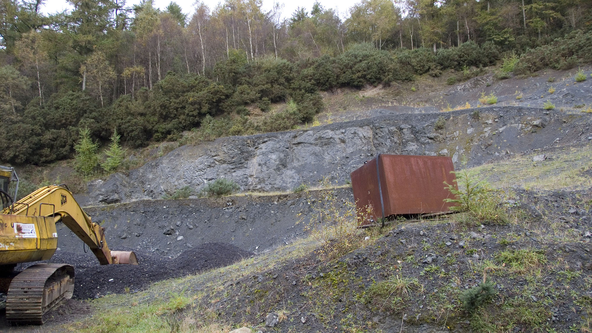
The original photographs show steep quarry faces, loose scree and an excavator. They are historical evidence of hazards, not a current safety assessment. Ask the landowner to confirm the present working status and areas permitted for the visit. Do not enter an active working area, approach machinery or stand beneath a face; rock can fall without warning, including when nobody is operating the quarry.
Use the agreed track, wear stout footwear and carry water for the long return walk. Wet mudstone, loose blocks and woodland surfaces can be slippery. A companion and a charged phone are sensible, but mobile reception has not been established. Stop if the route or collecting area differs from the agreed arrangement. This is not a suitable casual collecting site for children.
Equipment
A hand lens, camera, scale, notebook, labels and a small padded container are useful for examining and recording authorised finds. Take water and weatherproof clothing. If limited splitting of loose blocks is specifically permitted, use appropriate tools and eye protection, keep other people clear and avoid heavy loads for the return walk. The old recommendation to fill bags or take bulk processing samples is not a current collecting allowance.
Cleaning And Treating
Label each lawfully collected piece with its precise source before cleaning, distinguishing loose scree from an observed horizon. Mudstone may split or soften when wet, and pale shell material can be fragile. Begin with gentle dry brushing and photograph details before removing more matrix; avoid prolonged soaking, pressure washing and acids. Keep counterparts together and retain enough surrounding rock to support the fossil. Seek specialist advice before preparing an unusual trilobite or dense fossil cluster.
Identify Your Finds
Need help identifying a fossil? Share clear photos, where you found it and its size with the community.
Further Reading
The Craighead Inlier: historic Glenmard quarry and Quarrel Hill excursion
BGS: Geology of the Ayr district
BGS Lexicon: Quarrel Hill Formation
McCormick: trilobite research including Glenmard material
Lamont: the Drummuck Group, Girvan
Evans: cephalopod study with comparative Glenmard specimens
NatureScot: Scottish Fossil Code
Access Rights
Arrange landowner permission before visiting or collecting. A past record states that the landowner allowed two collecting hours; that was a specific historical arrangement, not continuing consent or a guaranteed offer. Agree the date, route, parking, areas, time limit, tools and amount of material for your own visit. The available evidence establishes neither a current refusal nor unrestricted access.
Official NatureScot checks on 14 October 2026 found no SSSI or Geological Conservation Review boundary intersecting the original guide point or a 500 m buffer. This corrects the old guide’s unqualified SSSI statement for the mapped locality; it does not establish the status of every historical quarry footprint or the approach. Nearby protected sites must not be treated as part of this pit, and a different agreed collecting area should have its own boundary check.
Permission to enter does not automatically permit removal of fossils. Ask the landowner to confirm authority for collecting and retaining them; where the fossil or mineral rights are held separately, the relevant rights holder’s permission is also needed. Active quarries do not carry a general right of access, while a disused quarry’s access position is a separate question from fossil ownership. If protected ground is involved, obtain any additional consent required for the proposed activity rather than assuming the mapped-pit check covers it.

Read and follow the Scottish Fossil Code. Collect sparingly within the agreed conditions, record locality and horizon honestly, and report a potentially important find with photographs and its position before attempting an unplanned extraction.
It is important to follow our Code of Conduct when collecting fossils or visiting any site. Please also read our Terms and Conditions.
Links
♦ Fossil Discussions
♦ Fossil Articles
♦ Buy Fossils, Tools and Equipment
♦ Buy Crystals, Meteorites, and Artefacts
♦ Join Fossil Hunts
♦ UK Fossils Network


