
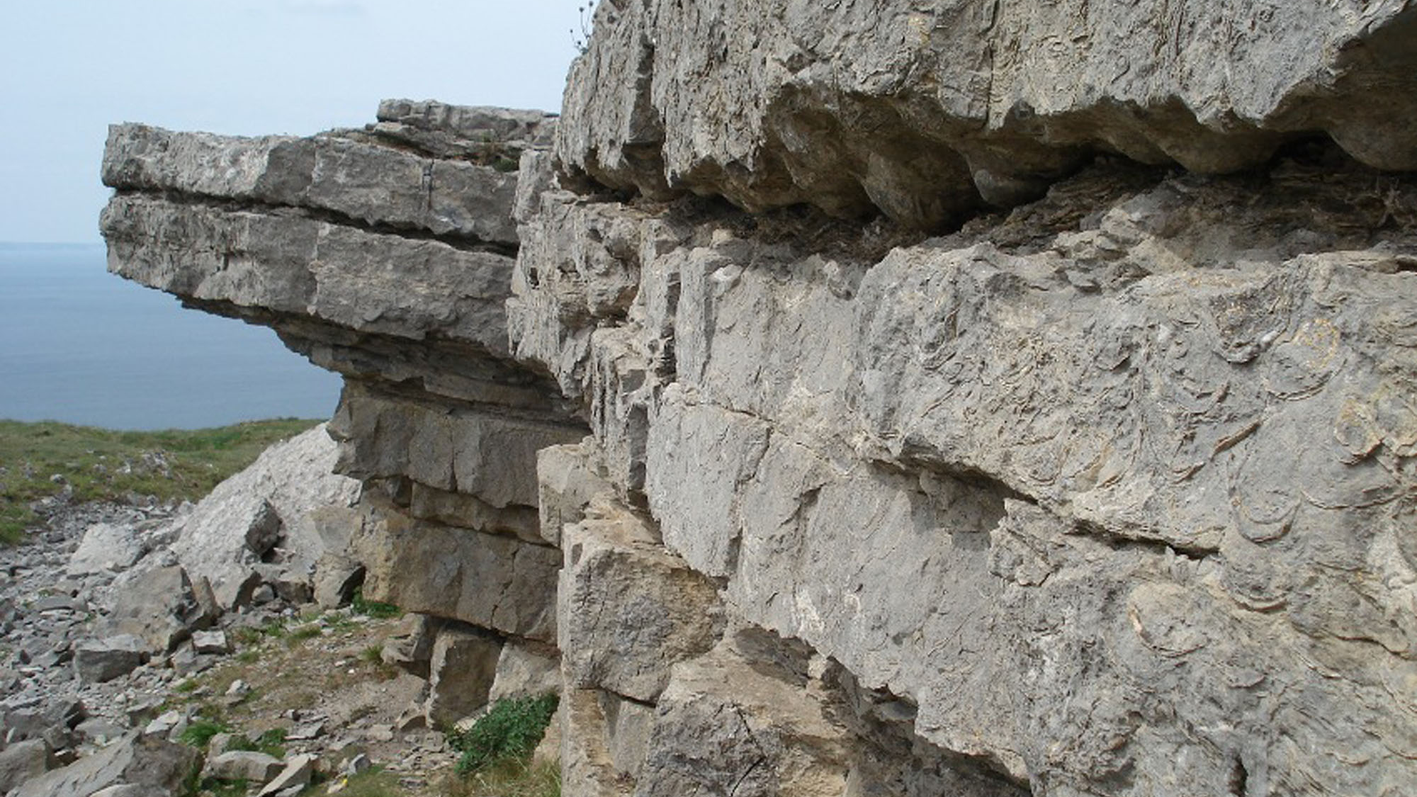
Overview
Directions
- Approach Great Orme from Llandudno. The headland has walking routes, a summit road and tramway; check current operating arrangements and charges before travelling.
- From the summit visitor-centre area, follow the signed historical trail towards Bishop’s Quarry. Use the paths and quarry floor to view the exposed limestone, rather than approaching cliff edges or walking beneath unstable faces.
- Allow time for uneven ground and exposed weather. Marine Drive is also a traffic route, so use designated safe stopping and walking places rather than standing in the road to inspect rock.
Location photographs
Swipe to browse · Select a photograph to enlarge


Fossil Hunting
Bishop’s Quarry is the clearest starting point for recognising Great Orme’s fossils. Large brachiopod shells and their moulds are displayed on weathered limestone surfaces, sometimes crowded together on a bedding plane. Look from the established paths and safe parts of the quarry floor. A broad view first helps you distinguish the layered rock from individual fossils before concentrating on a close detail.
The giant productoid brachiopods are especially memorable. Gigantoproductus is well documented at the quarry: its broad, strongly curved shell and repeated ribs can be recognised even where only a mould remains. Some specimens show a hollow impression where shell material has disappeared; others preserve relief above the surrounding limestone. A genus-level identification is usually more realistic than a species name from an incomplete surface.
Corals provide a useful comparison. A solitary coral may show radiating internal partitions in cross-section, while a colony contains repeated corallites, seen as tubes or closely packed sections according to the orientation of the rock surface. Shell ribbing runs across the outline of a brachiopod, whereas the internal structure of a coral is organised around its corallites. Crinoid remains can appear as small discs, cylinders or broken skeletal fragments mixed into the limestone.
The detailed quarry log records smaller brachiopods, bryozoans, bivalves, an orthocone nautiloid and a trilobite tail fragment as well as the conspicuous large shells. These are scientific records from particular logged intervals, not a promise that each can be located on an ordinary visit. Darker muddy partings preserve a different-looking assemblage from the shell-rich limestone, and the finest details may only be visible in historical study material.
Elsewhere on the headland, natural exposures can be obscured by lichens, while quarry surfaces expose clearer shapes. Dolomitisation and silicification have altered some rocks and can blur or destroy fossil textures. Do not remove lichen, scrape surfaces or shift loose stone to obtain a clearer view. The photographs below include both close fossil details and their wider rock setting, which is often the most useful comparison.
Record a fossil with a close photograph, a scale placed beside it and a wider photograph showing its position in the rock. Low-angle natural light brings out ribs and relief without cleaning. Leave every fossil and stone where it is: this is an observation and photography locality, with the local restrictions explained under ACCESS RIGHTS.

Fossil photographs
Swipe to browse · Select a photograph to enlarge


Discoveries and milestones
Significant discoveries, geological research and conservation milestones at Great Orme.
1876 – Foraminifera from Great Orme described
H. B. Brady published work on Carboniferous foraminifera from Great Orme. The later geological account considered Bishop’s Quarry a likely source, but the exact quarry provenance is uncertain.
1898 – The Llandudno limestone succession investigated
G. H. Morton published a study of the Llandudno limestones that included Great Orme mapping and classification, contributing to the early scientific subdivision of the headland.
1925 – Detailed stratigraphy and fossils studied
L. B. Smyth published detailed work on Great Orme’s succession and fossils. Figured coral and chaetetid material from the headland survives in a geological museum collection; these specimens should not all be described as types.
1927 – Caninia Band coral material figured
H. P. Lewis figured Caninia benburbensis material from Great Orme’s historical Caninia Band. The surviving museum record identifies figured material, rather than establishing a type specimen or an occurrence in the principal Bishop’s Quarry.
1945 – A Bishop’s Quarry brachiopod described
C. J. Stubblefield erected Eomarginifera cambriensis using material from Bishop’s Quarry, linking the locality with the formal description of a Carboniferous brachiopod.
1956 – Giant productoid brachiopods examined
J. E. Prentice studied Gigantoproductus edelburgensis and related material, including specimens from Bishop’s Quarry. This was later research on the species, rather than its original naming.
1982 – Historical specimens catalogued
A museum catalogue brought together type, figured and referred collections, including Great Orme material tied to several historical horizons and separate headland exposures. It preserves valuable provenance without making every listed specimen a type.
1984 – Measured Great Orme sections published
The Rhyl and Denbigh geological memoir documented the local succession, including the Happy Valley cycles, the detailed Bishop’s Quarry face log and the separate section southwest of Craig Rofft. These records remain important evidence for the fine-scale geology of the headland.
2009 – Craig Rofft correlation revised
A modern Carboniferous framework reconciled older local terminology and placed the Craig Rofft Sandstone Member in the Cefn Mawr Limestone Formation, using evidence for a Brigantian age.
2016 – Depositional and alteration history reassessed
Integrated research examined how basin evolution influenced sedimentation, dolomitisation and mineralisation at Great Orme, developing the interpretation beyond the older simple limestone subdivisions.
Geology
The Great Orme is built largely from Carboniferous limestone of the Clwyd Limestone Group. Its rocks record repeated changes across a shallow tropical marine platform, rather than a single reef growing continuously through the whole succession. Shell debris, coral skeletons and carbonate mud accumulated during marine phases; muddy intervals and surfaces affected by exposure record changes in conditions and sea level.
The modern succession includes the Llanarmon, Loggerheads, Cefn Mawr and Red Wharf limestone formations. Older accounts used local names such as Pier Dolomite, Great Orme Limestone, Bishop’s Quarry Limestone and Summit Limestone. These names remain useful for recognising historical measured sections, but their boundaries do not all translate neatly into a simple modern list. In particular, replacement dolomite cuts across stratigraphic divisions, so the historic Pier Dolomite cannot simply be treated as another name for all of the Llanarmon Limestone.
The Loggerheads Limestone contains repeated limestone packages, historically described as cycles around Happy Valley. The Tollhouse Mudstone is now classified as a bed within that formation. The shell-rich and muddier beds at Bishop’s Quarry belong to the Cefn Mawr Limestone succession. The Craig Rofft Sandstone Member is also placed in the Cefn Mawr Limestone Formation by the modern framework, following evidence for a Brigantian age; its former assignment to the Loggerheads Limestone is outdated.
The younger Red Wharf Limestone includes cherty and sandy skeletal limestone. Faulting, tilting and later changes to the rock complicate what is seen at any one exposure. Dolomitisation replaces the original limestone minerals and can obscure shells, while silicification produces resistant chert. These processes explain why neighbouring surfaces may differ so strongly in fossil visibility and why a photograph of the surrounding rock is valuable alongside a close-up of a specimen.
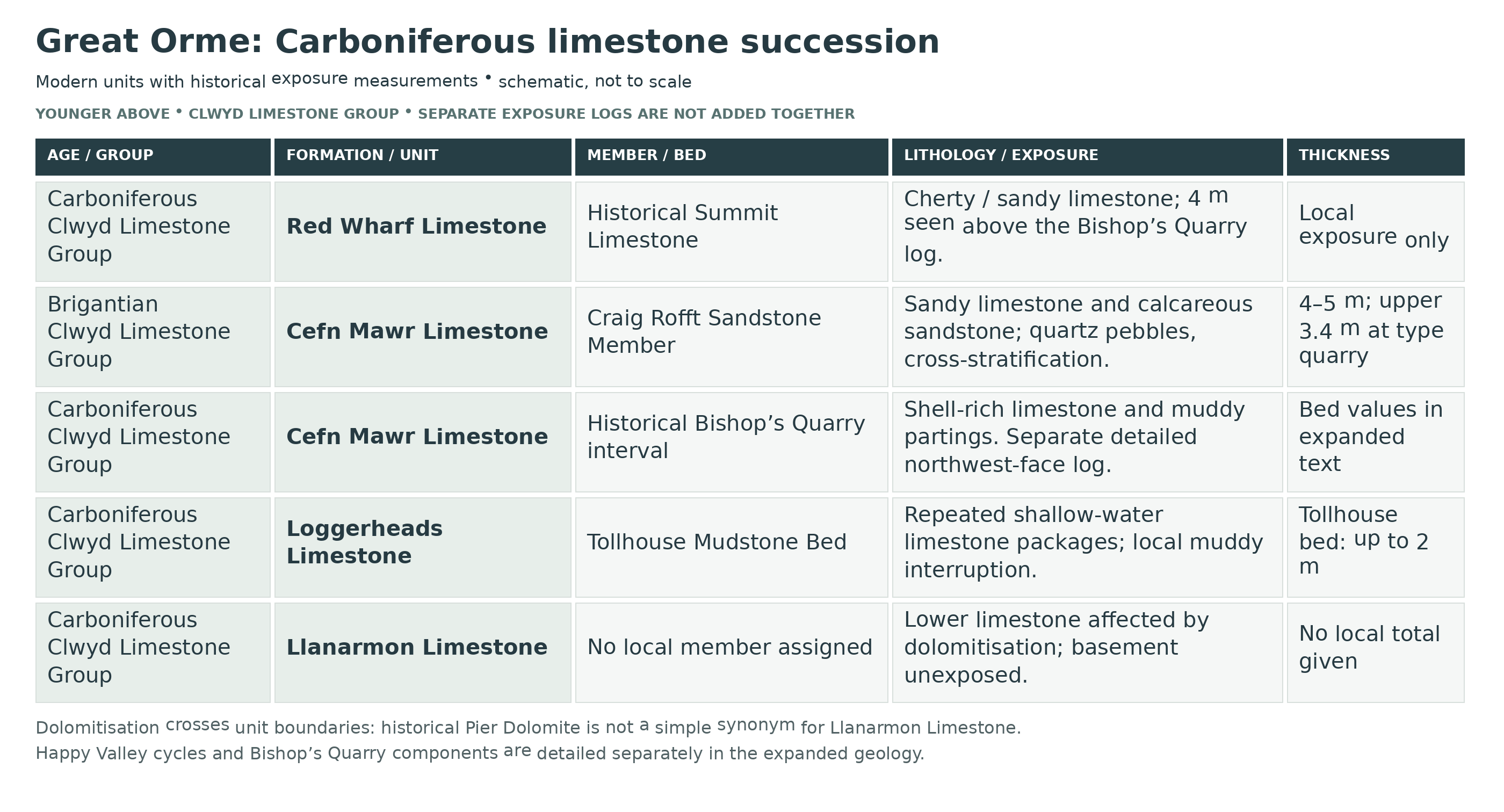
Detailed geology and bed-by-bed succession
Detailed geology and stratigraphy of Great Orme
The succession below uses modern formation names, with historical local names retained where they identify measured sections. The Happy Valley cycle log, Bishop’s Quarry face log and the short section southwest of Craig Rofft are separate records, not one continuous newly measured column. All thicknesses are scoped to the stated historical exposure. Fossil names within those logs retain historical determinations and qualifiers rather than implying that every name has been revised taxonomically.
CLWYD LIMESTONE GROUP
Llanarmon Limestone Formation
The basement beneath the Great Orme limestone succession is not exposed. Extensive dolomitisation affects the lower part of the headland succession, including the Llanarmon Limestone. Replacement of the original carbonate can obscure bedding and destroy shell textures, although pockets of crinoidal limestone survive. Regional formation thicknesses are not measurements of the Great Orme.
Historical Pier Dolomite. This name describes altered rock in older accounts and is not a safe one-to-one synonym for the entire modern Llanarmon Limestone Formation. The limestone immediately beneath the Tollhouse Mudstone Bed is assigned to the Loggerheads Limestone in the current definition. Dolomitisation crosses stratigraphic divisions, so the alteration must be distinguished from the age and original sedimentary unit of the rock.
Historical Pier Dolomite type section and fossiliferous lenses. The eastern section near the Grand Hotel and pier, continuing north beyond the toll gate, was described as about 140 m of mainly medium- to coarse-grained dolomite. Dark-grey limestone survives in thin bands and lenses, commonly rich in crinoid debris; elsewhere replacement has destroyed the original rock texture. A thin crinoidal limestone lens about 7.6 m below the top yielded Gigantoproductus of the maximus group and Megachonetes cf. papilionaceus. The 7.6 m figure is its position below the top, not the lens thickness. Morton also recorded Syringopora ramulosa in limestone beds beyond the pier. These are historical records from the dolomitised succession, not a measured thickness or fauna list for the modern Llanarmon Formation alone.
Southern and northwestern dolomite exposures. The historical account describes probably about 90 m on the southern slopes overlooking Loreto College and Gogarth Abbey, mostly massive dolomite with clearer bedding in its higher parts and small-scale cross-bedding visible on some weathered surfaces. At the northwestern coast, about 12 m was recorded at high-water mark, including a conspicuous red band 0.6–1.0 m thick. These are separate local exposures, not additional intervals to total with the eastern type section or present-day access recommendations.
Loggerheads Limestone Formation
Pale, shell-rich limestone forms repeated shallow-water packages. Rubbly intervals and exposure or soil-related surfaces interrupt more massive limestone. The historical Great Orme Limestone cycles described around Happy Valley preserve this repetition in much greater detail than a formation-level summary. They are not a claim that every bed is currently exposed or safely accessible on a visitor route.
Tollhouse Mudstone Bed. This calcareous mudstone and argillaceous limestone interval, up to 2 m thick, lies within the Loggerheads Limestone Formation. Its type section is on the west side of Marine Drive, about 100 m north-northwest of the tollhouse, and on the shore below. The muddy interval records a temporary change from dominant carbonate accumulation and contains a historical shell and ostracod fauna. This is geological locality information, not advice to stand in the road or scramble to the exposure. The old assignment as a member of the Leete Limestone is superseded.
Tollhouse type-section fauna and lateral thinning. The historical type section at SH 7815 8326 contains 1.2–2.0 m of dark-grey calcareous mudstone and earthy limestone. Its recorded fauna includes Gigantoproductus of the maximus group, Linoprotonia, Megachonetes cf. papilionaceus, Schizophoria, Bellerophon, Aviculopecten and ostracods. Below the lighthouse the interval is about 1 m thick and thins westwards. The memoir’s regional marker Daviesiella llangollensis was not found on Great Orme and is not added to the locality’s fossil record. The old local formation terminology is superseded by the modern bed rank used above.
Happy Valley historical measured cycles, youngest to oldest. The following component descriptions retain the order of the published 1984 log, descending from Cycle 9 to Cycle 1 and the Tollhouse Mudstone. Covered intervals are retained because they are part of the measured record. The digitised Cycle 2 table has an ambiguous break between a “5” entry and a 14.63 m continuation; these are reported explicitly rather than combined into a newly invented thickness. The Cycle 1 record Koninckophyllum θ is retained in its historical notation without inferring a modern species identification.
Cycle 9, logged component 1 (3.35 m). Limestone, grey to pale grey, thin-bedded, slightly porcellanous; Lithostrotion junceum, Syringopora cf. distuns, Delepinea?, Eomarginifera sp., Gigantoproductus sp., Megachonetes sp., Pugnax pugnus, Straparollus sp.
Cycle 8, logged component 1 (6.1 m). Limestone, pale grey to brown, rubbly to massive; Lithostrotion portlocki, Gigantoproductus sp.
Cycle 8, logged component 2 (13.1 m). Limestone, pale, in 0.5 to 1-m beds; Lithostrotion portlocki, Athyris expansa, Gigantoproductus sp. maximus group, Megachonetes sp.
Cycle 7, logged component 1 (6.1 m). Limestone, grey, rubbly in part; Dibunophyllum bourtonense, Syringopora cf. geniculata, Antiquatonia sp., Gigantoproductus sp., Megachonetes sp.
Cycle 7, logged component 2 (6.1 m). Limestone, grey, thick-bedded; Chaetetes depressus, Gigantoproductus sp. maximus group, Linoprotonia sp., Naticopsis?.
Cycle 6, logged component 1 (2.74 m). Limestone, pale grey, with pink rubbly beds; Lithostrotion maccoyanum, L. portlocki.
Cycle 6, logged component 2 (7.31 m). Limestone, poorly exposed.
Cycle 6, logged component 3 (1.83 m). Limestone, grey, massive; Axophyllum vaughani, Lithostrotion pauciradiale, Palaeosmilia murchisoni, Syringopora cf. geniculata, smooth spiriferoids.
Cycle 5, logged component 1 (2.74 m). Limestone, grey, rubbly.
Cycle 5, logged component 2 (1.83 m). Limestone, grey, well bedded; Gigantoproductus sp., Megachonetes cf. papilionaceus, smooth spiriferoid, Bellerophon sp.
Cycle 4, logged component 1 (3.05 m). Grass-covered slope.
Cycle 4, logged component 2 (1.83 m). Limestone, pale grey.
Cycle 4, logged component 3 (14.63 m). Limestone, poorly exposed, pale grey; clisiophylloid indet., Megachonetes cf. papilionaceus, Gigantoproductus sp. [juv.], pectinoid indet., trilobite cephalon indet.
Cycle 3, logged component 1 (11.89 m). Limestone, grey, rubbly; Koninckophyllum?, Lithostrotion aff. martini, Palaeosmilia murchisoni, Syringopora cf. geniculata, Linoprotonia cf. hemisphaerica.
Cycle 3, logged component 2 (17.37 m). Limestone, grey; Caninia aff. juddi, Chaetetes depressus, Dibunophyllum bourtonense, Koninckophyllum sp. [juv.], Lithostrotion aranea, L. junceum, L. pauciradiale, L. cf. sociale, Palaeosmilia murchisoni, Syringopora cf. geniculata, S. cf. reticulata, Gigantoproductus sp., smooth spiriferoids.
Cycle 2, logged component 1 (10.67 m). Grass-covered slope with poor exposure of grey limestone.
Cycle 2, limestone entry with ambiguous thickness. Limestone, pale grey to grey; Caninia sp., Koninckophyllum sp., Lithostrotion junceum, L. martini, L. pauciradiale, Palaeosmilia murchisoni, Syringopora cf. ramulosa, Gigantoproductus sp. maximus group, Pleuropugnoides sp., Schizophoria sp. The digitised table prints “5” beside this entry; the following fauna continuation is printed beside 14.63 m. The layout is ambiguous and no corrected combined measurement is inferred.
Cycle 2, continuation printed beside 14.63 m. Macrochilina sp., Meekospira sp., Naticopsis sp., Straparollus sp., Streblopteria sp., Weberides sp. This continuation is retained with its printed measurement, subject to the table-layout uncertainty explained above.
Cycle 1, logged component 1 (2.43 m). Grass-covered slope.
Cycle 1, logged component 2 (3.66 m). Limestone, pale grey; Aulophyllum fungites cf. redesdalense, Dibunophyllum bourtonense, Koninckophyllum θ [historical notation], Lithostrotion martini, L. sociale, Syringopora cf. ramulosa, Athyris expansa, Gigantoproductus sp., Linoprotonia sp., Megachonetes cf. papilionaceus, Bellerophon sp., Koninckopora inflata.
Cycle 1, logged component 3 (7.62 m). Limestone, grey; Caninia sp. subibicina group, Lithostrotion martini, L. aff. martini, L. pauciradiale, Syringopora cf. ramulosa, Megachonetes cf. papilionaceus, Productus sp., Schizophoria sp.
Cycles 1 and 2 were historically grouped as the Lithostrotion affinephillipsi beds. The alternation of hard, massive limestone and softer rubbly cycle tops gives parts of the headland a stepped profile. Such historical coral-zone terminology is not an additional modern formation or a separate proven bed at Bishop’s Quarry.
Lighthouse horizon. The historical Lighthouse horizon is a rubbly, nodular limestone band about 2 m thick near the lighthouse. The 1984 memoir traced it into the rubbly top of Cycle 5 in the section north of Happy Valley, then along Craig Rofft towards Ogof Deuben. Its local thickness near the lighthouse does not replace the 2.74 m rubbly component measured in the Happy Valley cycle log. This is a historical correlatable horizon, not a new formal member or an invitation to approach the sea cliffs.
Caninia Band and cliff-forming limestone. The succession comprising Cycles 6–9 at Cregiau Cochion contains Smyth’s historical Caninia Band; the memoir also describes the same upper-cycle sequence in cliffs and scars above the lighthouse. The account does not pin the band to a numbered component of the Happy Valley table, so no new bed number or thickness is assigned. Lower in the succession, Cycle 3 is Smyth’s historical “massive white limestone” and forms the cliffs at Pen-trwyn and is also described below the lighthouse and around Cregiau Cochion. These outcrop relationships help explain the headland’s stepped relief without joining separate exposures into an invented continuous log.
Cefn Mawr Limestone Formation
Repeated muddy limestone and mudstone packages alternate with shell-rich limestone. Marine deepening phases brought muddier conditions than those typical of the shallower Loggerheads packages. The historical Bishop’s Quarry Limestone interval is the principal fossil-viewing target of this guide; its large productoid shells occur alongside smaller shelly fossils in the more argillaceous beds.
Bishop’s Quarry northwest face: historical measured log, oldest to youngest. The logged sequence begins with at least 0.22 m of dark limestone. The nine components below are followed by 4 m seen of the historical Summit Limestone. These are face measurements, not the whole formation thickness. The south face overlaps this record and reaches slightly lower strata; it must not be appended as though it extended the northwest face into one continuous stack.
Northwest face, component 1 (seen to 0.22 m). Limestone, dark grey.
Northwest face, component 2 (0.60 m). Mudstone and shaly limestone; Antiquatonia sp., Eomarginifera sp., Lingula sp., Megachonetes sp., Rugosochonetes sp., smooth spiriferoids, Spirifer bisulcatus, Posidonia becheri, Streblochondria sp.
Northwest face, component 3 (0.90 m). Limestone, dark grey.
Northwest face, component 4 (0.15 m). Mudstone with limestone lenses.
Northwest face, component 5 (2.43 m). Limestone, grey; Gigantoproductus edelburgensis, G. cf. tulensis, Martinia sp., Productus hispidus, orthocone nautiloid.
Northwest face, component 6 (0.52 m). Mudstone and limestone, dark grey; Amplexizaphrentis derbiensis, Diphyphyllum lateseptatum, Rhipidomella michelini.
Northwest face, component 7 (1.13–1.28 m). Limestone, grey.
Northwest face, component 8 (0.22 m). Mudstone, black, with lenses of earthy limestone; Amplexizaphrentis derbiensis, Fenestella sp., Eomarginifera cambriensis, E. cf. lobata, Megachonetes sp., Productina margaritacea, Rhipidomella michelini, trilobite pygidium.
Northwest face, component 9 (3.65 m). Limestone, dark grey, with mudstone partings: Chaetetes depressus, Gigantoproductus crassiventer, G. edelburgensis, G. cf. moderatus, G. cf. tulensis, G. sp.[latissimoid], Pugilis pugilis, Rugosochonetes sp.
Bishop’s Quarry south face and bedding. The southern face at SH 7668 8300 overlaps the northwest-face succession and reaches slightly lower beds. Additional historical records comprise Lithostrotion maccoyanum, Fistulipora incrustans, Penniretepora, trepostomatous bryozoans and Rugosochonetes speciosus. The limestones range from fine or very fine grained to coarser where skeletal remains are abundant; ordinary beds are usually 15–20 cm thick, exceptionally about 0.5 m. Closely spaced joints in some fine limestone can resemble cleavage, with recorded dips of 70–90° and strikes ranging from east-southeast to north-northeast. These structures are distinct from bedding and add to the need for caution around faces.
Historical correlation and nearby Bishop’s Quarry Limestone exposures. Earlier palaeontological work compared the quarry beds with the Hardraw Limestone of the Yorkshire Dales, using the historical P1c zonal framework; that is a published correlation, not a reason to import Yorkshire beds or thicknesses. Southwest of the quarry, basal beds of the historical local unit are grey to dark-grey, thinly bedded limestone with silicified productoids and a little pale chert. A separate exposure north of the summit buildings at SH 7667 8356 shows 3 m of dark-grey to black, partly flaggy limestone with abundant productoids, while the small quarry east of the summit at SH 7721 8312 shows 1.5 m of dark-grey, well-bedded limestone with thin shale partings. These isolated measurements remain separate from the principal quarry-face log.
Craig Rofft Sandstone Member
The Craig Rofft Sandstone Member belongs to the Cefn Mawr Limestone Formation. The modern framework places it in the Brigantian following foraminiferal dating, superseding its former assignment to the Loggerheads Limestone. Its 4–5 m succession comprises red or purple sandy limestone and calcareous sandstone, locally with quartz pebbles and shell concentrations. The partial type quarry exposes the upper 3.4 m. The base is not exposed: the modern definition places it at the incoming sandy limestone and calcareous sandstone above sand-free limestone of the Cefn Mawr Limestone Formation. These figures have different scopes and must not be treated as conflicting measurements of exactly the same exposure.
Internal sandstone structure and upper contact. The lower part is mottled and bioturbated; the upper approximately 2 m is cross-stratified. The member is interpreted as an upper-shoreface deposit. At the type section its top is an undulating surface beneath a thin, impersistent, calcretised porcellanous limestone bed assigned by the modern framework to the Red Wharf Limestone Formation. The overlying cap is therefore not part of the sandstone member.
Historical thin-section observations. Samples from the Craig Rofft quarry contain mainly moderately sorted, subrounded quartz grains, with polygranular quartz conspicuous; the finer sample has more angular grains. Two coarser samples have dolomite cement and extensive replacement of grains, whereas the finer sample has closely packed grains in an illitic matrix with dispersed leucoxene and ferric oxide and lacks carbonate. Zircon dominates the recorded heavy-mineral assemblage, with conspicuous tourmaline and smaller amounts of rutile, garnet and apatite. These are observations of the sampled rocks, explaining their variable texture and alteration rather than defining new beds or a visitor mineral-collecting target.
Red Wharf Limestone Formation
Porcellanous sponge-bearing limestone above Craig Rofft. Immediately above the sandstone, the historical quarry account records 0.30 m of pale grey-brown porcellanous limestone. Smyth described a meandrine form of Chaetetes from this band in 1925; the 1984 memoir referred it to Chaetetipora. That published change of identification is retained as historical taxonomic context, not a new specimen determination. The memoir considered a limestone band in the nearby section at SH 7736 8300 probably equivalent, rather than proving an exact one-to-one correlation.
Separate historical section southwest of Craig Rofft, SH 7736 8300: oldest to youngest. This seven-component limestone log lies across the road and tramway from the sandstone quarry. It is described here with the overlying limestone discussion, not as components of the Craig Rofft Sandstone Member. Its porcellanous horizon was tentatively correlated with the sponge-bearing cap described above; that probable correlation does not independently fix every component against a modern formation boundary. The measurements belong to this short exposure alone: they are not added to either the sandstone thickness or the Bishop’s Quarry log. The location identifies the historical scientific record and is not a recommended roadside examination point.
Southwest Craig Rofft section, component 1 (0.79 m). Limestone, pale, sandy.
Southwest Craig Rofft section, component 2 (0.99 m). Limestone, grey and pale grey, intraclastic.
Southwest Craig Rofft section, component 3 (0–0.15 m). Limestone, porcellanous, pale brown, with earthy limestone and red mudstone.
Southwest Craig Rofft section, component 4 (0.10–0.25 m). Limestone, grey, rubbly; nodules of porcellanous limestone up to 15 cm across at base locally.
Southwest Craig Rofft section, component 5 (0.91 m). Limestone, grey, crinoidal, rubbly; a few brachiopods; Chaetetipora at base.
Southwest Craig Rofft section, component 6 (2.36 m). Limestone, pale grey to buff, intraclastic and partly sandy.
Southwest Craig Rofft section, component 7 (2.74 m). Limestone, grey to pale grey, rubbly.
Cherty or sandy skeletal limestone and mixed carbonate–siliciclastic cycles occur in the younger headland succession. The historic Summit Limestone includes 4 m seen above the northwest-face Bishop’s Quarry log. Other summit quarries expose cherty limestone or dolomite; an old quarry west of the summit was described with 10 m of dolomite containing irregular pale chert nodules. These are distinct local observations, not the complete thickness of the modern formation or assurance of present-day safe access.
Historical Summit Limestone: the 4 m quarry-top interval. At the northwest face of Bishop’s Quarry this interval is pale-grey or brown limestone, with abundant predominantly white chert in its upper half. The historical fauna includes Caninia cambrensis, C. juddi, Diphyphyllum lateseptatum, Koninckophyllum?, Antiquatonia, Gigantoproductus crassiventer, G. cf. moderatus, G. cf. tulensis, Linoprotonia, Pugilis pugilis and Spirifer. The list belongs to this historical local interval and is not transferred to every exposure of the Red Wharf Limestone. A quarry east of the summit at SH 7710 8338 also contains abundant, poorly preserved brachiopods in the historical Summit Limestone.
Other summit exposures: chert, brecciation and dolomite. The quarry at SH 7713 8332 shows grey to pale-grey, fine-grained limestone with pale chert in nodules and veins, locally brecciated and patchily dolomitised. A separate exposure at SH 7703 8342 shows about 8 m of fine-grained, thinly bedded cherty limestone; the cliff section north-northwest of the summit at SH 7671 8345 exposes about 12 m of similar but thicker-bedded rock. The 10 m of chert-nodular dolomite west of the summit belongs to the distinct quarry at SH 7648 8338. None of these measurements is added to the 4 m Bishop’s Quarry interval to manufacture a complete formation thickness.
Historical headland thickness estimates. Using its older local terminology, the 1984 memoir estimated about 70 m of the Gronant Group on Great Orme, incomplete at the top, with about 20 m of Bishop’s Quarry Limestone and a maximum of roughly 50 m of Summit Limestone. The Geological Conservation Review separately describes about 140 m visible in the Happy Valley type section out of an estimated 175 m of the historical Great Orme Limestone. These estimates concern different historical units and exposure scopes, not an additional stack to sum. They are retained as context, not equated to the complete thicknesses of the modern Cefn Mawr or Red Wharf formations and not substituted for the explicitly scoped measured sections above.
The Red Wharf Bay type-section thickness and the Castell Mawr Chert Member belong to Anglesey and are not imported as a Great Orme bed stack. Similarly, channel fills described elsewhere in the formation are not automatically features of Bishop’s Quarry. The local record is best understood from the measured headland sections and their explicitly stated exposure limits.
Structure, alteration and displaced blocks. Tilting and faulting affect the succession, while dolomitisation and silicification change the rock’s mineralogy and the visibility of its fossils. Modern work relates these changes to the wider evolution of the basin, rather than one simple reef history. The displaced cherty block at Gorsedd Uchaf has been discussed in terms of both glacial transport and collapse; its origin should not be presented as settled.
Additional uncorrelated field observations. Grundy Ridewood’s 2013 field guide, based on an unpublished undergraduate project, describes a lower grainstone interval at Happy Valley about 10 m thick, with an undulating clast-supported breccia about 2.5 m above its base, and strongly bioturbated red marls between limestone packages. At Craig Rofft it records lateral changes in colour, grain size and sandstone development. These are attributed observations, not a correlation with particular numbered components of the historical logs. The guide’s alternative formation mapping and thickness estimates are not adopted here in place of the modern framework and its defined contacts.
Historical museum records: separate headland horizons. The 1982 Trinity College Dublin catalogue preserves specimen-based evidence from several Great Orme exposures. Its historical names, locality descriptions and age qualifiers are retained here without turning them into modern bed correlations, new thicknesses or present-day collecting directions. “Figured” and “referred” records are not automatically type specimens, and material from elsewhere on the headland is not assigned to the principal Bishop’s Quarry.
Shale at the base of the historical Lithostrotion affine-phillipsi beds. Records from 300 yards west of Pen-morfa Lodge include figured Carcinophyllum vaughani (TCD F77), Dibunophyllum aff. muirheadi (F73–F75, with additional referred material R10), and Lonsdalia duplicata (F76; the catalogue flags the generic spelling as historical). Figured Lophophyllum material (F81) carries a historical taxonomic symbol whose meaning is not resolved here, rather than a guessed species name. These series include both figured pieces and associated unfigured material. Other headland records from the affine-phillipsi beds, without that precise shale locality, comprise referred Tabulipora howsei var. nov. (R11) and Productus sp. nov. (R12); the provisional labels are those of the historical record.
Caninia Band, beds above it and Lighthouse horizon. Caninia benburbensis material (F100) from the headland’s historical Caninia Band includes a specimen figured by Lewis in 1927. The catalogue tentatively gives an Asbian/Brigantian age, which is not converted here into a precise modern bed age. Figured Dibunophyllum (Histiophyllum) sp. nov. (F78) comes from beds above the Caninia Band, 300 yards south of the lighthouse; figured Rhodophyllum sp. nov. (F79) is recorded from the Lighthouse horizon, 190 yards southwest of it. These are distinct historical collection positions and provisional identifications, not additional fossils proved in Bishop’s Quarry.
Other quarry and headland records. Figured Zaphrentis cf. oystermouthensis (F80) is labelled from the historical Bishop’s Quarry Beds, but its recorded quarry is 390 yards east of the summit; the unit name is not evidence that it came from the principal quarry. Referred Productus “x” (R13) has only a headland locality within those historical beds. The catalogue also records figured Chaetetes septosus material (F82) from Great Orme and associated Chaetetes sp. material (F71) from an abandoned quarry described as 680 feet east of the semaphore, 1,200 feet southeast of the lighthouse and 486 feet above Ordnance Datum. F71 comprises unfigured parts associated with the figured specimen BM R24997; it must not be relabelled as a series of figured types. These old reference points are collection provenance, not newly verified navigation.
References
Warren, Price, Nutt and Smith, 1984: Geology of the Rhyl and Denbigh district
Waters and colleagues, 2009: Carboniferous lithostratigraphical framework
BGS Lexicon: Llanarmon Limestone Formation
BGS Lexicon: Loggerheads Limestone Formation
BGS Lexicon: Tollhouse Mudstone Bed
BGS Lexicon: Cefn Mawr Limestone Formation
BGS Lexicon: Craig Rofft Sandstone Member
BGS Lexicon: Red Wharf Limestone Formation
Geological Conservation Review: North Wales Shelf
Juerges and colleagues, 2016: basin evolution, sedimentation and diagenesis at Great Orme
Grundy Ridewood, 2013: Great Orme field guide, attributed observations
Nudds, 1982: catalogue of type, figured and referred fossils, Trinity College Dublin
Safety
There are unprotected drops around the summit and headland, as well as steep and unstable quarry faces. Keep to established paths, stay clear of the ground below loose rock and do not climb faces or fallen blocks. Supervise children closely.
The headland is exposed to wind and changing weather. Wear sturdy footwear and carry suitable clothing. Take care beside Marine Drive and other roads, and never stand in traffic to examine an exposure.
Equipment
A camera or phone, hand lens and photographic scale are sufficient for studying the fossils. Bring sturdy footwear, weather protection and a notebook to record where photographs were taken. Do not bring extraction tools or packing material for taking fossils away.
Cleaning And Treating
Fossils and stone must remain undisturbed at Great Orme. Do not scrape, brush, wash or chemically clean a fossil, and do not remove lichens to reveal its surface. Photographs in changing natural light can show the detail without altering the rock.
Identify Your Finds
Need help identifying a fossil? Share clear photos, where you found it and its size with the community.
Further Reading
British Geological Survey: Geology of the Rhyl and Denbigh district
BGS: A lithostratigraphical framework for the Carboniferous successions of southern Great Britain
Geological Conservation Review: North Wales Shelf, including Great Orme
Geoscience Wales: The geology of the Great Orme
Conwy County Borough Council: Great Orme historical trail
Access Rights
Great Orme is a country park with public walking routes and visitor facilities. Public access does not include permission to collect its fossils: the council’s historical trail says not to remove or break them, and the country-park byelaws prohibit removing or displacing stone, including loose material. Enjoy the fossils by observing and photographing them in place.
The headland is also protected for its scientific interest. Follow local signs and the country-park rules, keep away from unstable ground, and do not hammer, extract or move material. Road and tramway charges and operating arrangements should be checked with the operator before travelling.
It is important to follow our ‘Code of Conduct’ when collecting fossils or visiting any site. Please also read our ‘Terms and Conditions‘
Joe Shimmin. Last inspected 2008, Updated 2017, Edited by Jon Trevelyan 2016
Links
♦ Fossil Discussions
♦ Fossil Articles
♦ Buy Fossils, Tools and Equipment
♦ Buy Crystals, Meteorites, and Artefacts
♦ Join Fossil Hunts
♦ UK Fossils Network


