
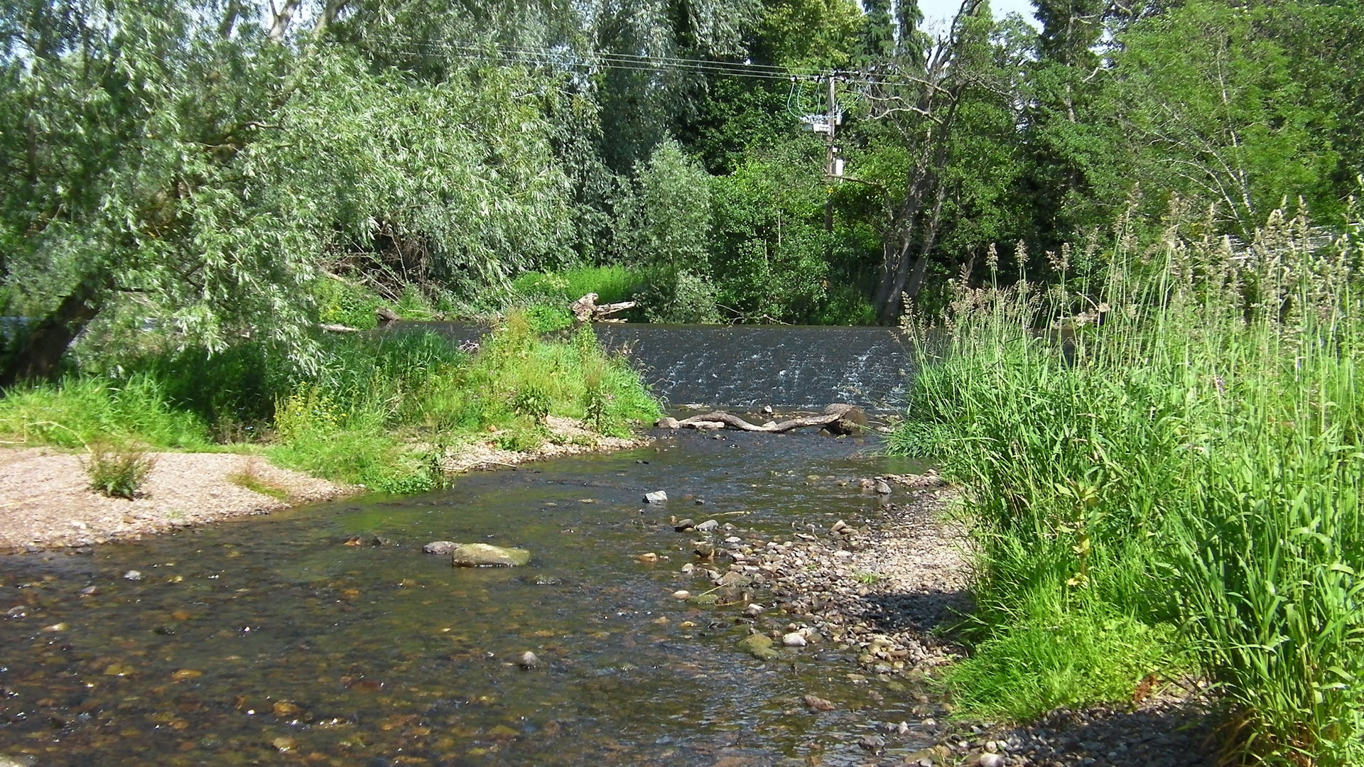
Overview
Directions
- From the A1, turn off for Haddington and continue through the town towards Sidegate and the B6369.
- At the end of Sidegate, turn towards Aubigny Sports Centre. Use permitted parking and check the current signs and time limits; the centre’s parking is not a guarantee of unrestricted parking for river visitors.
- Join the riverside path towards the white Stevenson footbridge and West Mills Weir. Use the bridge to cross the river, and keep to safe dry paths and banks. The council’s Haddington Paths leaflet shows the walking network.
- Locality reference: NT 51477 73526. This identifies the collecting reach, not a parking space or a safe river crossing.
Location photographs
Swipe to browse · Select a photograph to enlarge


Fossil Hunting
The interest here lies in comparing loose fossil-bearing stones with the shell-rich rocks recorded in the river bed. The original collecting photographs show mixed, rounded and subrounded pebbles and cobbles, with fossiliferous pieces among smoother quartz, chert and volcanic-looking stones. On accessible dry ground, examine naturally weathered surfaces with a hand lens rather than breaking rocks at random. Slight differences in colour and relief can reveal a shell edge or a cluster of crinoid fragments. Obtain the relevant owner’s permission before taking any material.
Crinoid remains are among the most recognisable reported finds. Their stems commonly break into small disc-like ossicles, seen as round or ring-shaped sections on a worn limestone surface; several crowded together can make a rock look speckled. The original photographs include disarticulated crinoid material. These fragments are useful evidence of marine life, but they do not by themselves identify the limestone from which a pebble came.
Brachiopods reported in the guide include productid and spiriferid forms. Look for ribbed shells or shell moulds rather than expecting complete, free-standing specimens: river abrasion may expose only part of a shell within the rock. Colonial corals, previously reported as Lithostrotion, and gastropods are also recorded by collectors. Repeated coral tubes and their internal partitions differ from the curved or coiled outline of a gastropod. These broad recognition clues are more reliable than assigning a species to a worn fragment.
The earlier guide also reported rare small trilobites as Paladin mucronatus. That species identification has not been corroborated for this exact reach by a documented specimen in the sources reviewed, so treat it as a historical collector report rather than an expected find. Photograph any possible trilobite clearly, retain its precise find information and seek specialist identification before preparing it.
About 45 m downstream of the white Stevenson footbridge, the previous guide recorded a bivalve-rich river-bed ledge. Its close-up photographs show many pale, curved shell sections in dark rock, giving a different appearance from the scattered fragments in river pebbles. View it only where visible from a safe dry bank; algae, water level and renewed sediment cover may obscure it. Neither its present exposure nor a safe route onto it is assured. Do not prise slabs from the ledge.
Plant-bearing material has also been reported upstream, including remains identified by earlier collectors as Stigmaria. Rounded surface markings on a weathered stone are not enough on their own to confirm that identification. Record the whole specimen as well as close-ups, and distinguish a loose transported find from rock genuinely attached to an exposure. The plant-fragment photographs are retained without assigning new species.
A much older scientific record comes from the Tyne bank opposite Haddington’s former distillery, between Haddington and Lennoxlove. The 1910 Geological Survey memoir lists plant remains, a bivalve and fish remains there. This nearby historical river-bank record enriches the locality’s story, but it is not proof that all those fossils occur in today’s photographed ledge or gravel. The detailed geology below preserves the historical names and the limits of the comparison.
Fossil photographs
Swipe to browse · Select a photograph to enlarge


Discoveries and milestones
A chronological record of fossil documentation and geological mapping around Haddington’s West Mill reach.
1860–1866 – First district geological mapping
The first geological map of Sheet 33 appeared in 1860, following work by H. H. Howell and A. Geikie; the East Lothian memoir followed in 1866. These established the district framework around Haddington, rather than documenting a fossil discovery at West Mill.
1910 – Fossil-rich bed recorded opposite the distillery
Following the 1902–1904 resurvey, the second East Lothian memoir described a conspicuous bivalve-rich band on the Tyne bank between Haddington and Lennoxlove and listed plants, bivalves and fish from the opposite-distillery locality. It correlated the band with the Lennoxlove borehole and other outcrops. This is a publication milestone: neither its first finder nor an exact discovery date is established, and the old exposure has not been proved identical to the modern bridge-side ledge.
1961–1962 – Haddington sheet resurveyed
M. F. Howells surveyed six-inch sheet NT 57 SW, which contains the West Mill collecting reach. This was a local mapping revision, not a documented new fossil discovery.
1978–1985 – Revised district maps and memoir
The Haddington district drift map appeared in 1978, the solid-geology map in 1983 and the accompanying memoir by A. D. McAdam and W. Tulloch in 1985. Together they provide the district context for the Carboniferous rocks and younger Tyne deposits; the memoir does not give a measured West Mill section.
Geology
Haddington brings together two very different geological records. Carboniferous rocks preserve shells, crinoids and plants from ancient environments, whereas the River Tyne has much more recently eroded, transported and redeposited pieces of those rocks. A fossil-bearing pebble is therefore older than the river gravel containing it. Its rounded form and its present position do not identify its original bed.
At the guide reference, current BGS 1:50,000 mapping shows alluvium over bedrock of the Aberlady Formation, within the Strathclyde Group. The formation is Asbian to Brigantian in age, within the Viséan of the Mississippian, or Lower Carboniferous. Regionally it contains sandstone, siltstone and mudstone with lesser coal, seatrock, carbonate and ironstone. Rivers and deltas supplied sediment to lakes and marine embayments, and repeated incursions of the sea produced marine fossil-bearing horizons. These are formation-wide characteristics, not a claim that every rock type is exposed beside the weir.
The river’s alluvium and patchy rock exposures can coexist: sediment covers much of the valley floor while erosion uncovers bedrock locally. The shell-rich ledge described by earlier visitors is an individual observation within this setting. It has not been assigned securely to a named member, limestone or marine band, and no complete measured succession is available for this exact stop. The older account of a “mussel-band” opposite the distillery is a useful comparison, not a demonstrated bed-for-bed match.
The loose marine fossils may have travelled from several Carboniferous limestone horizons upstream. Blackhall Limestone was the main source proposed in the old guide, but neither a dominant Blackhall contribution nor that limestone as the local bedrock is established. Other shelly and crinoidal limestones occur in the catchment. Keeping transported stones separate from the mapped Aberlady bedrock explains why a varied assemblage can occur in one gravel patch without representing one intact fossil bed.

Detailed geology and bed-by-bed succession
Detailed geology: river cover, Aberlady Formation, the historical shell bed and possible sources of transported fossils.
This account distinguishes mapped cover and bedrock, observed fossil-bearing material and possible upstream sources. It is not a measured vertical section. The 1:50,000 map supports a formation-level interpretation at NT 51477 73526; it cannot determine the bed in an individual ledge, the thickness of river sediment or the source of every loose stone.
Alluvium and active river gravel
Alluvium is mapped at the locality. In the wider Haddington–Stevenson valley, the district memoir describes fine sand and silt on the low floodplain, with sand and gravel in higher terraces. The active channel also contains mixed pebbles and cobbles, including fossiliferous rocks. Floods redistribute this material and alter exposed gravel patches. No local sediment thickness or fixed extent of the photographed bars is established. The contributions from fresh bank erosion, older terraces and other reworked deposits have not been quantified.
STRATHCLYDE GROUP
The Strathclyde Group is the formal parent of the Aberlady Formation mapped beneath the river deposits here. Its regional sedimentary succession records changing terrestrial, lake and marginal-marine environments. Only the formation supported at the guide point is described as local bedrock below; the wider district’s other formations are not a West Mill exposure sequence.
Aberlady Formation
Age, rocks and depositional setting
The formation spans the Asbian and Brigantian substages of the Viséan, Mississippian. Sandstone, siltstone and mudstone predominate, with subordinate coal, seatrock, carbonates and ironstone. The formal framework interprets a fluviodeltaic setting with lakes and marine embayments, punctuated by marine incursions. Sand records sediment carried by river systems; finer sediment accumulated in quieter water, while coal and seatrock elsewhere in the formation record vegetated surfaces. The formation-wide age and range of facies do not establish a finer age or environment for the photographed bivalve ledge.
Formal boundaries and thickness
The base is defined at the lowest Macgregor Marine Band, represented by the Saltoun Marine Band in the type section. The top is the base of the Upper Longcraig Limestone, the local equivalent of the Hurlet Limestone. Neither boundary is demonstrated as exposed at West Mill. Reference thicknesses of 134 m at Spilmersford and 139 m at Skateraw describe other sections; they are not the thickness exposed or penetrated here. No local thickness or securely assigned member is available.
The bivalve-rich river-bed exposure
The earlier guide places a shell-rich ledge about 45 m downstream of the white Stevenson footbridge. Photographs show numerous pale curved shell sections in dark rock, and wider views record the river-bed setting. The close-ups alone cannot identify the shells to species or prove that every photographed slab is fixed bedrock. It is best retained as an unnamed bivalve-rich exposure. Its precise position within the mapped formation, its contacts and its thickness remain unresolved; it should not be renamed Blackhall Limestone, Sandersdean Limestone or a marine band.
The historical distillery “mussel-band”
The 1910 memoir describes an easily recognised band containing abundant bivalves on the Tyne bank opposite the distillery between Haddington and Lennoxlove. It relates that occurrence to a mussel-band in a diamond bore at the old Lennoxlove limestone quarry and to separate surface occurrences near Stevenson House and between Sandersdean and Rentonhall. Stevenson House is a different locality from the white Stevenson footbridge. The historical distillery position is close enough to be relevant to this reach, but has not been fixed precisely enough to equate it with the present guide’s ledge.
The 1910 bed discussion says the characteristic bivalve was insufficiently preserved for accurate determination. Its palaeontological appendix nevertheless records the following under “R. Tyne, opposite the Distillery, Haddington”: Lepidodendron veltheimi Sternb.; Lepidostrobus sp.; Carpolites sp.; Naiadites obesa (R. Eth., jun.), with the historical note [Anthracoptera auct.]; and Elonichthys sp. These are historical identifications of plant, bivalve and fish material, not modern reidentifications of the photographed specimens. The list does not demonstrate that all five entries came from one measured lamina, and fish remains should not be presented as an expected modern find.
Plant-bearing material
Plant fragments are recorded in the original photographs, and the guide reports upstream finds identified as Stigmaria. No named plant bed or in-situ rooting horizon has been established at this stop. A marked surface on a loose rock does not demonstrate that the plant grew at the point where the stone was found. The older distillery plant records independently support plant preservation in this river reach, but do not confirm the modern Stigmaria identification.
Historical correlations and terminology
The 1910 account discusses a Sandersdean marine limestone, a separate planty limestone containing Platyostomella and the mussel-band. Their inferred ordering relies on discontinuous and locally faulted exposures and the Lennoxlove borehole. A marine calcareous sandstone below the borehole mussel-band was considered probably equivalent to Sandersdean Limestone. These are historical regional correlations, not three beds demonstrated at West Mill. In particular, the 7-inch mussel-band in the borehole is not a measured thickness for the river-bank band.
Aberlady Formation was introduced in 1989, replacing older Upper Lothian Group usage for this interval. Earlier memoirs describe relevant rocks within the broader Calciferous Sandstone Measures or Series; that older umbrella term is not a one-to-one synonym for Aberlady Formation. The detailed Spilmersford succession, including Tyneholm Beds, Winton Marine Band and Spilmersford Beds, is a separate reference section and cannot be transferred to this river stop.
Possible sources of transported marine limestone
The loose crinoidal, brachiopod-bearing and coral-bearing rocks need not all come from the mapped bedrock immediately beneath the weir. More than one fossiliferous limestone occurs in the drainage area. The following named units explain possible sources and regional relationships only; they are not additional beds measured in an exposed West Mill stack.
Blackhall Limestone and Skateraw terminology
Blackhall Limestone is a Brigantian named limestone within the Lower Limestone Formation of the Clackmannan Group. It is commonly crinoidal, bioclastic marine limestone, varying from hard to earthy and locally associated with calcareous mudstone. The modern Lexicon connects the older Middle and Upper Skateraw names with Blackhall. The district memoir describes the Skateraw outcrop belt upstream around Spilmersford, Glenkinchie, Lampland, Peaston, Dodridge, Hope and Magazine, including hard crinoidal limestone and finer calcareous beds. This makes it a plausible contributor to river stones, but neither its dominance nor the source of an individual specimen is proven. The Neilson Shell Bed lies above Blackhall regionally; an unverified trilobite report does not demonstrate that bed at this site.
Lower and Middle Longcraig limestones
Other possible carbonate sources occur within the upper Aberlady succession. At Belvidere Quarry near Lennoxlove, about 1.3 km south of the guide point, Lower Longcraig Limestone is described as crinoidal and shelly, with calcareous mudstone partings; the 1910 quarry attribution was qualified. That quarry’s assemblage is separate from the distillery list. Middle Longcraig Limestone occurs farther upstream on the Tyne below Herdmanston Mains and in the Birns Water west of East Saltoun, with shelly and crinoidal material, corals and brachiopods. Neither unit is established as the modern West Mill ledge or the source of any particular photographed pebble.
Limits of the local section
No complete measured succession, bed-level correlation or precise local structural measurement has been established for the collecting reach. The Lennoxlove borehole, Spilmersford type succession and Clerkington Weir investigations describe different sites. Their bed thicknesses, marine mudstones and rockhead estimates must not be used to fill gaps here. The most defensible picture is young river cover above mapped Aberlady Formation, with an observed shell-rich ledge and transported fossil-bearing stones of incompletely known origin.
References
British Geological Survey, Detailed Geology 1:50,000 map service, bedrock and superficial layers at NT 51477 73526, checked 14 October 2026.
BGS Lexicon: Aberlady Formation; Blackhall Limestone.
McAdam, A. D. and Tulloch, W. (1985), Geology of the Haddington district, BGS memoir, Sheet 33 W; Carboniferous and freshwater-alluvium accounts.
Clough and others (1910), The geology of East Lothian, second edition, pp. 54–57 and 209.
Browne and others (1999), A lithostratigraphical framework for the Carboniferous rocks of the Midland Valley of Scotland, BGS Research Report RR/99/07, section 5.10.
Dean and others (2011), A lithostratigraphical framework for the Carboniferous successions of northern Great Britain (onshore), BGS Research Report RR/10/07, section 4.3.16.
Safety
The principal hazards are the river, weir and slippery or undercut banks. Visit only in low, settled conditions after checking SEPA flood information and the weather upstream as well as locally. Keep well back from the weir edge, its drop and fast water. Apparently shallow water can conceal slippery rocks, holes and strong currents; gravel islands can be cut off.
Stay on safe dry paths and banks. Do not wade to the island, cross the weir or climb onto its structures; use the footbridge. Supervise children closely and keep them away from the water’s edge. Leave if the river rises or turns turbid, and avoid boggy or unstable bank margins after rain. In an inland water emergency, call 999 and ask for Fire and Rescue; do not enter the water to attempt a rescue.
Equipment
Wear sturdy footwear with good grip for the riverside paths. A hand lens, camera, notebook or phone and a small scale for photographs are the most useful tools. If you have permission to collect, carry labels, wrapping and a rigid box for fragile pieces. A hammer is unnecessary for examining river-worn surfaces, and this guide gives no authority to damage ledges or banks. Wellies do not make a river crossing safe. Cover cuts and clean your hands after handling wet river stones.
Cleaning And Treating
For lawfully collected material, record the find location and whether it was loose or attached before cleaning. Let wet specimens dry slowly at room temperature, then begin with a soft dry brush. Test any gentle water cleaning on a small area only if the matrix is stable: fine-grained, laminated or plant-bearing pieces may soften or split. Preserve both faces of a shell-rich slab and any useful surrounding matrix.
Calcitic shells and crinoids can break with the surrounding limestone, so avoid forcing hard matrix away. Fine mechanical work should be undertaken cautiously under magnification by someone with suitable experience. Do not use household acids, bleach or routine varnish. Consolidation is only for genuinely friable specimens; seek advice on a reversible conservation adhesive such as Paraloid B-72 when needed. Leave potentially significant fish, trilobite or plant material unprepared until it has been assessed.
Identify Your Finds
Need help identifying a fossil? Share clear photos, where you found it and its size with the community.
Further Reading
Geology of the Haddington district: BGS district memoir
Aberlady Formation: BGS Lexicon
The geology of East Lothian (1910): historical distillery record, pp. 55 and 209
Haddington Paths: council walking-route leaflet
Scottish Fossil Code
Access Rights
The riverside walk is shown in the council’s published path network, but a right to walk does not grant permission to remove fossils. Obtain the relevant landowner’s permission before collecting; no collecting permission is conveyed by this guide. Without it, enjoy observation and photography from safe public paths and dry banks. Respect signs, other visitors, wildlife and any temporary access restrictions.
No mapped SSSI or Geological Conservation Review site overlaps the checked West Mill reach in the official datasets reviewed on 14 October 2026. This does not remove the need for permission or responsible collecting, and it is not a statement about more distant upstream sites.

Scotland’s fossil resource needs responsible care. Read and follow the Scottish Fossil Code at all Scottish localities: collect lawfully, minimise damage and record important finds.
It is important to follow our Code of Conduct when collecting fossils or visiting any site. Please also read our Terms and Conditions.
Links
♦ Fossil Discussions
♦ Fossil Articles
♦ Buy Fossils, Tools and Equipment
♦ Buy Crystals, Meteorites, and Artefacts
♦ Join Fossil Hunts
♦ UK Fossils Network


