The Oligocene beds exposed along the coastline at Hamstead Cliff are exceptionally rich in fossils, particularly remains of mammals, crocodiles, turtles, fish and crustaceans. In addition, a wide variety of molluscs, plant material and fossil seeds can often be found scattered across the foreshore. This stretch of coast is widely regarded as one of the most productive fossil locations on the Isle of Wight, offering a remarkable diversity of finds for those willing to search carefully.


DIRECTIONS
FIND FREQUENCY: ♦♦♦♦♦ – The beds at this location are highly fossiliferous and rich in many types of fossils. These are also of very good quality, with superb preservation. This is a fantastic location to visit and the best on the island.
CHILDREN: ♦♦ – This location would be a perfect location for families, but access is a long walk down to the shore,
ACCESS: ♦♦ – Parking is via Nunney’s Wood car park, please note the roads leading to the coastal path are private and no parking is permitted. It’s a long walk to the shore, 3.5km, and when walking along the shore will be a looped 7.5km walk.
TYPE: – All of the fossils are found on the foreshore. You just pick them up.
♦ Park at the free Nunny’s Wood Car Park, accessed via Hamstead Drive. Although this is a private road, access is permitted as far as the car park. Do not attempt to park elsewhere on the road or drive beyond the car park, as this may block access and could result in enforcement action.
♦ From the car park, follow Hamstead Drive on foot all the way to the end. You will pass over a bridge crossing the creek, followed by a long walk up to the top of the road. At the top, you will reach a junction where the footpath splits—take the path heading north-west.
♦ The path will then split again, heading north-east and west. Both routes eventually lead to the coast, but we recommend taking the western path, then following the next footpath heading north. This route takes you through woodland and brings you out near the centre of the bay.
♦ From here, you can access the foreshore and walk along the beach towards Hamstead Ledge. It is possible to return via the alternative coastal path, which loops back inland and reconnects with the footpath network near Hamstead Farm.
♦ Due to the distance and tidal conditions, it is essential to allow enough time to return safely before the tide turns. The walk is approximately 3.5km to the shore, and around 7–8km in total if completing the full loop via Hamstead Ledge.
♦ Postcode to Nunny’s Wood Car Park; PO41 0YA. Google Map Link.
♦ What3Words to the shore entrance at the middle of the bay: ///proudest.liability.sharp
♦ What3Words to Hamstead Ledge (Second access point, or return path); ///outboard.padding.echo
DOWNLOAD THE UKF BOOKLET TO FOSSIL HUNTING AT BOULDNOR TO HAMSTEAD

A FIELD GUIDE TO COLLECTING BRITISH CENOZOIC FOSSILS
by Steve Snowball & Alister Cruickshanks
£21.99 (PAPERBACK)
FULL COLOUR – 190 PAGES
Available worldwide exclusively through Amazon
- Fossil identification plates
- Stunning locality and fossil photos
- Up-to-date geological & site information
- Best fossil-bearing sites in southern and eastern Britain described in detail
- Illustrations of life in deep time by Andreas Kurpisz
VIDEO FILM
FOSSIL HUNTING
The coastline around Hamstead Cliff represents one of the richest late Eocene to early Oligocene fossil localities in the UK, preserving an exceptional range of life from ancient freshwater and estuarine environments. Unlike fully marine sites, the sediments here record rivers, lagoons and coastal wetlands, offering a unique insight into ecosystems that existed around 33–37 million years ago.
Fossils are most easily collected along the foreshore, where erosion constantly releases material from the cliffs. Among the most frequently encountered finds are crocodile and turtle remains, including teeth, scutes and shell fragments. The crocodile Diplocynodon is particularly common, with its distinctive teeth often found scattered amongst shingle and clay. Turtle fossils are also regularly encountered, including soft-shelled forms such as Trionyx and hard-shelled turtles such as Emys, typically preserved as broken shell plates.
Fish remains are widespread and include small teeth, vertebrae and scales, often requiring careful searching due to their size. Occasional crustacean fragments can also be found, although these are generally less common and often incomplete.


One of the defining features of this location is the abundance of plant material and fossil seeds within the Hamstead Formation. The well-known seed Stratiotes websterii is particularly common, although usually only recovered through sieving due to its small size. Other plant remains, including fossil wood and stems, reflect the dense vegetation that once surrounded these ancient waterways.
At the base of the cliffs, the Bembridge Marls are exposed and are especially rich in molluscan fossils. Bivalves such as Corbicula, Polymesoda, Mytilopsis and Ostrea can be found, sometimes forming concentrated layers. Gastropods including Potamides, Melanoides, Viviparus and Hydrobia are also abundant, representing a mix of freshwater and brackish conditions.
The Hamstead Member itself yields large numbers of freshwater molluscs, with Viviparus and Unio being particularly common. These can often be found loose on the foreshore or weathering out of softer sediments, sometimes in considerable quantities.
Although rarer, mammal remains are among the most significant discoveries from this site. These include isolated teeth and bone fragments from early mammals such as Palaeotherium and Anoplotherium, along with other small ungulates. These finds are often subtle and require close inspection to identify.
Careful, methodical searching is key to success. The most productive areas are typically found along the tideline and at the base of the cliffs, where recently eroded material accumulates. Many of the best finds are made by searching slowly and closely, often at ground level.
Sieving is highly recommended at Hamstead. By collecting sediment and processing it through a fine mesh sieve, it is possible to recover a wide range of small fossils, including seeds, teeth and micro-remains. Drying and sorting material at home can reveal an impressive diversity of specimens that would otherwise be overlooked.
Some of the most significant fossil discoveries from Bouldnor and Hamstead Cliffs include classic Oligocene mammal finds, important reptile and bird records, type specimens of mammals, and one of the most important late Palaeogene plant floras in Britain.
1856 – Edward Forbes described the Bembridge Oyster Bed and the fossil-rich Bouldnor–Hamstead succession
Edward Forbes was one of the earliest workers to document the fossil-bearing beds at Bouldnor and Hamstead. His work helped establish the importance of the succession, including the oyster-rich horizons and the fossiliferous marls and clays that later became famous for mammals, reptiles and plants.
1925 – Cooper’s classic work on anthracotheres confirmed Bouldnor as a major site for large Oligocene mammals
By the early twentieth century, Bouldnor Cliff had already become known as a classic British site for larger Paleogene mammals, especially anthracotheres. Cooper’s 1925 work is one of the key landmarks in that history and helped establish the site’s reputation for important mammal remains.
1927 – Dyspterna woodi named from Bouldnor Cliff
Bouldnor Cliff provided the type specimen of Dyspterna woodi, named by Hopwood in 1927. This makes the site the type locality for one of its characteristic fossil mammals and adds to its importance in British Palaeogene mammal studies.
1963–1978 – Chandler described the important Hamstead Member plant flora from Bouldnor material collected by G.W. Colenutt and R.L.E. Ford
The fossil flora of Bouldnor Cliff was described in a series of works by Marjorie Chandler, based largely on material collected by G.W. Colenutt and R.L.E. Ford. These studies helped show that Bouldnor preserves the youngest known Palaeogene plant macrofossils in southern Britain, including important conifers, aquatic plants and pyritised plant remains.
1972 – Butselia biveri recorded from the site
The presence of the insectivore Butselia biveri at Bouldnor/Hamstead was noted by Butler in 1972. This was one of the important smaller mammal records from the site and later became significant in discussion of faunal change across the Eocene–Oligocene transition.
1974 – Bosma described the rodent fauna from the Hamstead Member
Bosma’s work on the rodent fauna showed how important Bouldnor and Hamstead are for small mammal assemblages as well as large mammals. These faunas became central to later biostratigraphic work on the late Eocene to early Oligocene of the Isle of Wight.
1979 – Glamys fordi named from a Bouldnor Cliff type specimen
Bouldnor Cliff also provided the type specimen of Glamys fordi, described by Bosma and de Bruijn in 1979. This is one of the locality’s key named mammal species and confirms the site’s importance for Oligocene rodent evolution and biostratigraphy.
1979 – fossil birds from the vicinity of Bouldnor Cliff were described by Harrison and Walker
Bird fossils from the Bouldnor area were described by Harrison and Walker in 1979, adding avian remains to the already important record of mammals, reptiles and plants. This helped underline how diverse the Bouldnor/Hamstead fauna really is.
1980 – Hooker and Ward summarised the reptile fauna, and Moody detailed the turtles
By 1980 the reptile fauna of Bouldnor and Hamstead had been recognised as the best British Oligocene reptile assemblage, including turtles, snakes and crocodilians. Hooker and Ward summarised the fauna, while Moody provided further detail on the turtles, helping establish the site as internationally important for Oligocene reptiles.
1980s–1990s – plant macrofossil work showed Bouldnor to be the youngest Palaeogene flora in Britain
Further work by Collinson and others on the plant-bearing horizons demonstrated that Bouldnor Cliff preserves the youngest known Palaeogene plant macroflora in Britain. The site is also the type locality for Sequoia couttsiae and is especially important for aquatic plants, conifers, seeds, leaves and pyritised logs from the Hamstead Member.
2004 – Hooker and colleagues showed the Bouldnor succession documents the ‘Grande Coupure’ within the Hamstead Member
Intensive collecting and screenwashing demonstrated that the famous mammalian turnover known as the ‘Grande Coupure’ occurs within the Hamstead Member rather than at its base. This made Bouldnor Cliff uniquely important in Europe for showing a superposed succession of mammal faunas across that major faunal change.
GEOLOGY
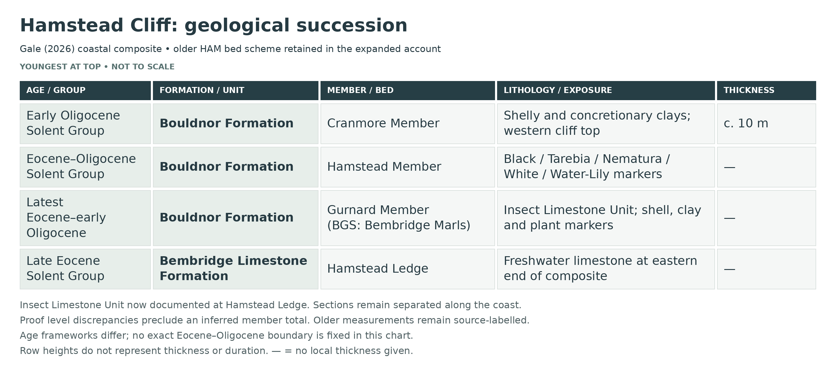
Hamstead Cliff belongs to the Bouldnor–Hamstead coastal succession of the Solent Group, spanning the latest Eocene and early Oligocene. Its principal units are the Bembridge Limestone Formation and the overlying Bouldnor Formation, whose members are the Gurnard (traditionally Bembridge Marls), Hamstead and Cranmore in Gale’s 2026 terminology.
The Bembridge Limestone and Bembridge Marls are best documented towards Hamstead Ledge at the eastern end of the tract. The marls comprise fine muddy sediments, shell seams and plant-bearing horizons deposited in quiet fresh to brackish water. Their basal oyster layer is thin. Gale (2026) documents an Insect Limestone Unit with micritic limestone lenses at Hamstead Ledge, updating older accounts that regarded it as absent here.
The Hamstead Member forms much of the cliff succession. Black Band, Nematura Bed, White Band and Water-Lily Bed are key markers within clay, silt, lignitic and shelly intervals. The mammal change associated with the Grande Coupure lies within this member; it is not simply the boundary between Bembridge Marls and Hamstead beds.
The younger Cranmore Member is documented at the cliff top near Cranmore Avenue, farther west. Its Cerithium and Corbula beds record renewed brackish and marine influence. It should not be described as merely late Eocene river sediment or assumed to overlie every currently accessible exposure.
The section follows a shallow synclinal structure and is repeatedly obscured or displaced by landslips. The detailed account retains the published bed framework, distinguishes Hamstead foreshore from the western cliff-top exposures, and identifies differing source measurements instead of presenting a single permanently exposed vertical log.

This is a detailed stratigraphic breakdown of the late Eocene to early Oligocene succession at Hamstead Cliff, Isle of Wight. The section exposes the top of the Bembridge Limestone Formation at Hamstead Ledge, the full Bembridge Marls Member on the foreshore, the Hamstead Member in the main cliff, and the Cranmore Member at the top of the western cliff, recording repeated shifts between freshwater, brackish, lagoonal, floodplain and more marine conditions.
New measured-section account: Gale (2026)
Gale (2026), following King (2016), uses the name Gurnard Member for the interval called Bembridge Marls Member in BGS (2015), here written as Gurnard Member. These are alternative names for the same part of the Bouldnor Formation, not two superposed units. The survey below uses Gale’s terminology and measured-section framework. The separately labelled older account retains the useful HAM bed numbers, fossils and historical measurements; its numerical divisions must not be spliced into the new survey.
The lower section is the Hamstead Ledge and adjacent foreshore succession; the middle and upper units include the Bouldnor landslip and western cliff-top exposures. These are correlated coastal sections, not all beds visible in one face. The following individual markers follow Figures 4–7 and the associated text.
SOLENT GROUP
Bouldnor Formation
Gurnard Member (Bembridge Marls Member in BGS 2015)
Basal oyster shell bed and eroded limestone contact
At Hamstead Ledge, the Gurnard Member rests on an eroded surface of the Bembridge Limestone. Its basal shell bed includes material reworked from that limestone and marks renewed transgression. This is a local shell-bearing horizon, not the thickness or sandy facies of the Oyster Bed at Whitecliff.
Insect Limestone Unit at Hamstead Ledge
Gale’s Figure 4 places this unit between 0.3 and 0.7 m in the Hamstead log. Dark laminated clays contain syneresis cracks, rare halite pseudomorphs and lenses of concretionary micritic limestone; Figure 6C shows the limestone lenses in place. This direct observation updates older statements that the Insect Limestone is absent from the Bouldnor–Hamstead tract. It does not demonstrate the same productive insect assemblage as at Gurnard or Saltmead.
T/P marker
Figure 4 distinguishes the T/P marker above the Insect Limestone Unit, within the lower succession of shell beds, silts and clays. The published abbreviated label is retained without expanding it into an unverified taxonomic or formal bed name.
Serpulid marker
A separate serpulid-bearing horizon lies above the T/P marker in Figure 4. It is one of several faunal markers used to correlate the lower Gurnard Member; it is not merged with the basal Oyster Bed.
Pc marker
The separately labelled Pc marker follows the serpulid horizon in Figure 4. Its published abbreviation is retained, and no independent thickness or unverified species identification is assigned.
Lower green marker
The lower conspicuously green clay marker is distinguished in Figure 4 and the Hamstead foreshore photograph, Figure 6A. It belongs to the lower rhythmic succession with shell-rich cycle bases and pedogenically modified clay tops.
Dark clay marker
The dark clay marker forms a distinct level between the lower green marker and the overlying green-clay interval. It is useful for local correlation rather than evidence for one uninterrupted dark bed throughout the member.
Middle green-clay marker
The separately illustrated green interval above the dark clay marker lies below the Potamomya marker. Across the lower member, mottling, local decalcification, desiccation cracks and rooted or slickensided cycle tops record repeated emergence and soil development.
Potamomya marker
This bivalve marker is individually labelled between the middle and upper green markers in Figure 4. Shell-bearing layers within this part of the member record short brackish-water incursions into the muddy coastal plain.
Upper green marker
The upper green marker in Figure 4 and Figure 6A is distinct from the lower and middle green intervals. Its separation preserves the published sequence of coloured-clay and shell-bed markers without treating every green clay as one correlatable bed.
Polymesoda obovata marker
A brackish shell bed rests on an omission surface penetrated by Thalassinoides burrows. This sharply based marker caps the lower marker-rich succession and is traced between northwestern sections and the more silty Howgate–Whitecliff succession.
Upper rooted clay cycles and organic-rich cycle bases
Above the lower markers, grey clays alternate with thin dark laminated organic-rich beds at cycle bases. Densely rooted cycle tops, siderite concretions and mineralised root traces are characteristic; local channel cutting is shown in Figure 4. These repeatedly soil-modified beds are not one homogeneous marl interval.
Nystia Bed
Gale describes a 2 cm brackish mollusc layer at 24.9 m in the Hamstead log. This is a distinct upper Gurnard Member marker, below the Black Band, and must not be confused with the separate Nystia-named horizons of older formations elsewhere on the island.
Silt marker immediately below the Black Band
Figure 4 distinguishes a silt horizon near the top of the Gurnard Member below the basal Hamstead Black Band. It is separate from the more conspicuous indurated silt higher in the lower Hamstead Member.
Hamstead Member
Black Band and basal rooted surface
The basal Hamstead marker is 0.7 m of dark grey laminated freshwater clay in Gale’s account, directly above a palaeosol with sideritic concretions. Older accounts give a thinner Black Band estimate; the new measurement is not silently substituted into the older HAM/GCR log.
Lower Hamstead scoured clays and Viviparus lenses
Clays above the Black Band contain silt-filled scours and lenses of Viviparus. Gale contrasts their lack of palaeosols with the repeatedly rooted clay cycles below the member boundary.
Indurated silt marker
A prominent indurated silt lies above the lower scoured clays and below the Tarebia Bed. Figure 6D shows its foreshore exposure, and Figure 15 correlates this marker northeastwards. Conflicting printed level ranges are not used to manufacture an exact thickness.
Tarebia Bed and desiccated upper surface
Small brackish gastropods pack this shell bed. Shell-filled Thalassinoides burrows extend 35 cm down into the underlying clay, while a desiccation-polygon surface immediately above records a subsequent exposed phase.
Rooted pale grey clay below the Log Bed
About 1 m of pale grey clay separates the Tarebia interval from the Log Bed. A sharp upper surface bears dense fine rootlets descending about 0.4 m into the clay.
Log Bed at Hamstead–Bouldnor
The log-bearing clay occupies 37.1–37.4 m in Gale’s Figure 4 and is laminated at its base. Large conifer trunks characterise this bed immediately below the Nematura Bed. Gale restricts this particular Log Bed to the Hamstead–Bouldnor section; logs also occur within the Nematura Bed, so wood alone does not identify a unique level.
Nematura Bed
Dark shelly clays above the Log Bed contain densely packed lenses of the brackish bivalve Polymesoda convexa, often in convex-up orientation, and additional logs. The bed passes upward into laminated silt with partly decalcified bivalves and increasingly strong soil mottling. The new survey therefore preserves more than the older description as a gastropod-rich lignite.
Decalcified palaeosol cycles below the White Band
Between 43 and 47.4 m in the Hamstead log, rhythmic silts and clays are extensively decalcified. Yellow-brown mottling, slickensides and thin separating grey clay layers mark individual soil-modified cycles; concretions are absent from this particular interval.
White Band in the new Hamstead log
Gale places the White Band at 47.4–53.1 m. Green-grey clays contain mollusc-rich lenses and siderite concretions. Brackish shell lags, including bivalves in life position, pass up into freshwater-gastropod-bearing clay and rooted, slickensided palaeosols. This broader logged interval is distinguished from the 1.8 m White Band entry of the older GCR table.
Post-White Band silts, clays and red palaeosol
Approximately 4 m of soil-modified silts and clays above the White Band end in a conspicuous brick-red palaeosol, shown at 56.3 m in Figure 4. Gale correlates this marker towards Thorness, where the intervening succession is thinner.
Bouldnor slip interval formerly poorly exposed
The interval between the White Band and Water-Lily Bed includes red-mottled palaeosols, silt beds and green or partly laminated silty clays exposed in the Bouldnor slip. The nineteenth-century gap of about 18 m reflects poor exposure in the older account, not demonstrated absence of strata.
Fish-otolith-bearing silty clays
Gale records fish otoliths in the sublaminated silty clays at 65.7–67 m in the Bouldnor upper-succession log. This is a separately documented fossil-bearing interval below the leaf bed.
Water-Lily or leaf bed
At 73.8 m in Figure 5, the leaf bed is only 5–7 cm of dark laminated carbonaceous clay. It overlies pale grey clay with vertical roots, itself above pale blue-green clay with siderite nodules. The bed was found on the third landslip tier; this new thin-bed measurement is distinct from the older 0.6 m table entry.
Mottled clays above the leaf bed
About 8.5 m of brown-grey clay with palaeosol mottling overlies the Water-Lily Bed. It is retained as a distinct post-leaf-bed interval rather than being collapsed into an undifferentiated upper clay summary.
Pyritic clay and rooted silt interval
At 82.7 m in Figure 5, dark grey pyritic clay contains rooted silt beds and passes upward into pale grey clay rich in siderite nodules.
Pale blue unionid-bearing clays
The 87.7–89.6 m interval consists of bright pale blue clays with siderite nodules and abundant unionid bivalves, recording freshwater conditions high in the Hamstead Member.
Upper red palaeosol and turquoise clay
A conspicuous upper red palaeosol lies about 1.4 m below the Cranmore base. Bright turquoise clay immediately below that boundary provides a further lithological marker; neither colour should be confused with the older red marker above the White Band.
Cranmore Member
Sharp Cranmore basal contact
Gale gives approximately 10 m of Cranmore Member in the western Bouldnor cliff-top section. Its base, at about 95.2 m in Figure 5, rests sharply on turquoise clay. This is a western coastal composite observation, not a unit exposed above every Hamstead collecting spot.
Lower shelly and rooted clays: Cerithium interval
The lower Cranmore alternates grey-brown shelly clays with pale blue-grey rooted clays. Figure 5 identifies the Cerithium interval within this lower part, reflecting the renewed influence of saline water.
Lentidium horizon
Figure 5 separately identifies a Lentidium-bearing level below the prominent middle-member silt. It is retained as a named faunal horizon without inventing an individual bed thickness.
Cranmore silt at 98.8 m
A distinct silt at 98.8 m in the Bouldnor log separates the lower alternations from the overlying thicker grey-clay succession.
Cuma horizon
The Cuma label in Figure 5 lies above the silt marker, within the upper clay succession. It is kept as Gale’s faunal horizon label, without treating it as a formal member.
Upper concretionary clays and Corbula interval
Above the silt, about 5.5 m of grey clay contains spheroidal and septarian carbonate concretions. Figure 5 places the Corbula interval high in the member. In the uppermost metres aragonitic shells are absent, although occasional large oysters remain; loss of aragonitic fossils is not evidence that those beds were originally unfossiliferous.
Erosional top and younger cover
The preserved Palaeogene succession is truncated. Figure 5 shows younger gravel above the Cranmore; the contact is an unconformity, not a continuation of the Palaeogene member sequence.
Measurement and interpretation limits
The printed proof gives inconsistent numerical levels for the Gurnard–Hamstead boundary and some lower Hamstead markers. Their order is secure in the illustrated sections, but a corrected member total or precise height for an ambiguous marker is not inferred here. Metre levels below refer only to the explicitly named published log, not height above today’s beach.
The mammal turnover is placed within about 4 m above the Nematura base in Gale’s discussion. His interpretation questions a large hiatus associated with the Log Bed, while older mammal-based work proposed a substantial break. That disagreement is retained rather than converting either interpretation into a proven erosional gap. Gale also retracts his earlier C13n assignment for the basal normal-polarity interval in favour of King’s C15n interpretation.
Older GCR/HAM reference account
This is a published composite framework for the Bouldnor–Hamstead coastal tract, not a single upright cliff log. The Bembridge Limestone and HAM-numbered marl beds belong to the eastern Hamstead Ledge/foreshore part; Hamstead beds occur in scattered cliff sections, and Cranmore beds are documented near Cranmore Avenue farther west. These geographical limits are retained for each part rather than assigning the entire succession to every collecting spot. The HC labels below belong to the older reference account and are editorial guide divisions. Numerical bed estimates below follow GCR Table 3.6 (2005); older GCR 10 values differ and are not combined with them.
SOLENT GROUP
Bembridge Limestone Formation (Upper Eocene)
Hamstead Ledge Freshwater Limestones
Bed HC1 — Freshwater Limestones Of Hamstead Ledge
Three freshwater limestone beds are developed at Hamstead Ledge at the eastern end of the section. These hard pale limestones form the resistant ledge on the foreshore and represent shallow freshwater to slightly brackish pond or marsh deposits laid down before the marlier Bouldnor Formation succession. Freshwater gastropods and associated lime-mudstone partings are typical, and the ledge provides the foundation on which the overlying Bembridge Marls are best examined at low tide.
Bouldnor Formation (Upper Eocene To Lower Oligocene)
Bembridge Marls Member
Bed HC2 — HAM I–IV, including the basal oyster bed (whole interval c. 0.9 m in the older table)
Grey and black clays with shelly partings and a thin oyster shell bed at the base, resting on an omission surface above the Bembridge Limestone. This thin oyster-bearing cap is the local expression of the basal transgressive shell horizon, rather than the thick sandy Bembridge Oyster Bed of Whitecliff Bay and records the main transgressive phase at the base of the Bembridge Marls. The fauna is low-diversity and brackish-water in aspect, with considerable water movement indicated by shell concentrations and comminution.
Bed HC3 — HAM V (c. 0.3 m)
Greenish-grey clay containing bands with Melanoides acuta, Serpula sp. and Viviparus lentus. This thin but distinctive horizon records fluctuating salinity and a mixed brackish to freshwater lagoonal fauna.
Bed HC4 — HAM VI–X (c. 2.7 m)
Grey and blue-green laminated clays with brackish-water bivalves and gastropods. Fine lamination and the restricted fauna indicate quiet-water lagoonal conditions, and these beds are among the best examples at Hamstead of the varve-like clay-silt lamination characteristic of the Bembridge Marls.
Bed HC5 — HAM XI–XIV (3.6 m in GCR Table 3.6)
Mudstones and siltstones with a bivalve band. These beds remain mainly quiet-water lagoonal deposits but show slightly more silt input and local shell concentration. They are important in the cliff and foreshore because they mark the transition from the lower more strongly brackish beds into the more varied central part of the member.
Bed HC6 — HAM XV–XXII (combined middle Bembridge Marls interval)
This central interval includes black clay with gastropods, green mudstone with lignitic layers, green clays and white marls with bivalves, and freshwater clays and silts. It records repeated shifts between low-salinity lagoon, freshwater pond and floodplain-waterbody conditions. Beds in this part of the section may contain seeds, molluscs and shell bands, and it is one of the most environmentally variable parts of the Bembridge Marls at Hamstead.
HAM XV (0.2 m)
Black clay with gastropods.
HAM XVI–XVIII (1.8 m)
Green muds with a lignitic band.
HAM XIX (0.3 m)
Green clay and white marl containing bivalves.
HAM XX–XXII (2.0 m)
Freshwater clay and silt overlie the bivalve-bearing marl.
Bed HC7 — HAM XXIII–XXV (c. 2.0 m)
Lignite and clay rich in water-plant seeds, leaf fragments and gastropods. This is one of the most distinctive plant-rich horizons in the whole Hamstead succession. Monocotyledonous leaf fragments and the water-plant seeds Brasenia and Stratiotes occur in association with Viviparus and the pulmonate Galba, showing very shallow standing freshwater rich in aquatic vegetation.
Bed HC8 — HAM XXVI–XXIX And HAM XXX (upper plant-rich Bembridge Marls)
Clays with seeds and molluscs followed by a thin lignite with seeds and molluscs. These beds continue the upper freshwater trend of the Bembridge Marls and are especially important for plant macrofossils, seeds and freshwater molluscs. They represent quiet lacustrine or floodplain-pool sedimentation with periodic accumulation of plant matter.
HAM XXVI–XXIX (5.7 m)
Table 3.6 records clays containing seeds and molluscs; the GCR local log also identifies an ironstone marker towards the top of this interval.
HAM XXX (0.1 m)
A thin seed- and mollusc-bearing lignite completes this upper plant-rich package. These are the 2005 table values; older figures of about 5.0 m and 0.6 m refer to the preceding published tabulation.
Bed HC9 — HAM XXXI–XXXIV (1.8 m in GCR Table 3.6)
Green, red and mottled clays forming the top of the Bembridge Marls Member. These beds reflect increasingly terrestrial, floodplain and upper-lagoon conditions, with oxidation, mottling and intermittent emergence. Vertebrate material may occur toward the top, and the interval marks the approach to the palaeosol and omission surface below the Black Band.
Published Bembridge Marls Thickness: About 21.5 Metres At Hamstead Foreshore
Individual horizons in the older GCR Figure 5.40 scheme
The following numbered levels and P labels belong specifically to that graphical Hamstead-foreshore log. They supplement the older bed prose above and are not presented as a precise numerical crosswalk to either GCR Table 3.6 or Gale (2026).
P1 plant horizon in GCR Figure 5.40
The first labelled plant horizon lies at the shell-bearing level numbered 15, above the rooted top of the preceding clay. It is separate from the lignitic mud band higher in the log.
P2 lignitic mud band
P2 is the conspicuous dark lignitic mud band at level 17 in Figure 5.40. It lies between the lower plant horizon and the overlying Corbicula-bearing interval.
Corbicula Bed in the older graphical log
Figure 5.40 identifies the Corbicula shell marker at level 19. The historical fossil label is retained as printed; an automatic equivalence with Gale’s separately named marker beds is not asserted.
P3 plant horizon
P3 is separately labelled in the interval numbered 20, above the Corbicula Bed and below the shell-bearing level 21 in Figure 5.40. No independent thickness or exclusive species assemblage is supplied by that figure.
P4 plant horizon
P4 is distinguished immediately above P3 around the transition to level 21. It is retained as a separate plant concentration, without inventing a diagnostic lithology not given by the source.
P5 plant horizon
P5 occurs in the interval numbered 22, below the laminated upper part of that package and beneath the rooted level 23. Its position separates it from both P4 below and P6 above.
P6 rooted plant horizon
P6 is placed at level 23, where Figure 5.40 shows roots above the laminated interval. This adds the rooted contact detail lost when the older middle marls are described only as one clay unit.
P7 plant horizon
P7 is separately marked in the lower part of the level-25 package above the level-24 interval. The figure does not support assigning it a distinct modern Gale bed number or a unique flora.
P8 plant horizon
P8 is the upper separately marked plant concentration in the same level-25 part of the old log, below the higher clays numbered 26–27. P7 and P8 are not one undivided plant bed.
Ironstone Band in the older graphical log
The Ironstone Band is shown individually at level 28, above the thick clay package numbered 26–27 and below the Nystia Band.
Nystia Band in the older graphical log
The shell marker labelled Nystia Band occupies level 30 in Figure 5.40, above interval 29. The figure’s numbered horizons are retained in their own scheme rather than forced into the differing tabulated HAM subdivisions.
Rooted upper contact and P9 context
The older graphical log shows a laminated level near 32 and rooted upper clay at 33. The associated plant-bed discussion places P9 in the basal Hamstead Black Band, above the Bembridge Marls plant horizons. These contacts are retained without turning all P labels into independently measured beds.
Hamstead Member
Bed HC10 — Black Band (c. 0.5 m in the older GCR table)
A carbonaceous black clay or lignitic mud marking the base of the Hamstead Member. At Hamstead Cliff it occurs low in the cliffs about 200 m east of the old line of posts and is one of the most important marker beds in the Bouldnor succession. Freshwater gastropods such as Viviparus are common, and autochthonous root systems penetrate the underlying palaeosol surface, showing that the base of the member is an omission surface with soil formation before renewed deposition.
Bed HC11 — Lower Hamstead Green And Black Clays (c. 8.1 m)
Green and black clays with bivalves and gastropods forming the lower Hamstead Member. These beds represent low-energy lagoonal to freshwater deposition and preserve the lower Hamstead fauna. Mudflows commonly obscure this interval in the cliff, but where exposed it yields molluscs, plant remains and vertebrates, including mammals in the broader Hamstead fauna.
Bed HC12 — Log Bed And Associated Lower Hamstead Deformed Sands
The older BGS account, summarising Hooker and co-authors, describes thin clayey sand below the Nematura Bed with water-escape structures and large conifer logs. The inherited description includes ball-and-pillow and convolute deformation, consistent with soft, water-saturated sediment disturbed soon after deposition. Plant seeds and leaves are recorded from the associated lower Hamstead beds. Gale (2026) describes the local Log Bed as a 0.3 m clay interval, laminated at its base, with large conifer trunks; the differing descriptions are retained as source-specific observations, not asserted to be identical measured lithologies or proof of a large hiatus.
Bed HC13 — Nematura Bed (c. 0.9 m in the older GCR table)
A black lignitic clay full of gastropods and one of the key dividing horizons within the Hamstead Member. Unlike the Black Band below, the Nematura Bed contains a distinctive brackish-water molluscan fauna and records renewed salinity increase. It is an excellent marker bed for separating the lower and upper parts of the Hamstead succession.
Bed HC14 — Lower Upper-Hamstead Green Clays With Ironstone Nodule Band (c. 10.8 m)
Green clays and silts with an ironstone nodule band and locally shell-bearing intervals. These beds make up a large part of the upper Hamstead Member at Hamstead Cliff and indicate renewed low-energy deposition on a broad lagoonal-floodplain plain. The interval is much obscured in places by landslip and mudflow but is important because it contains upper Hamstead vertebrate horizons in the broader Bouldnor–Hamstead section.
Bed HC15 — White Band (c. 1.8 m in the older GCR table)
Green clays with pale white shell-marls forming a conspicuous marker within the upper Hamstead Member. It is one of the clearest light-coloured horizons in the cliff and indicates a return to shelly, somewhat more calcareous standing-water conditions. This bed is widely used as a field datum in the Hamstead cliff section.
Bed HC16 — Green And Red Marls (20.7 m in GCR Table 3.6)
A substantial, mostly obscured interval of green and red marls above the White Band. These beds are partly obscured in modern exposures but represent alternating oxidation and waterlogging on a floodplain or very shallow lagoon margin.
Bed HC17 — Water-Lily Bed (c. 0.6 m in the older GCR table)
Laminated lignite rich in seeds, palm leaves, water-lily leaves and molluscs. This is one of the most distinctive plant beds in the Hamstead Member and indicates a quiet freshwater or very low-salinity waterbody with abundant floating and emergent vegetation. It is a key palaeobotanical horizon documented in the western Bouldnor part of this coastal composite.
Bed HC18 — Upper Hamstead Green And Mottled Clays With Lignite Beds And Shell Beds (c. 25 m)
Green and mottled clays with shell beds and thin lignitic horizons form the uppermost Hamstead interval in the older table. These beds record repeated freshwater, brackish and floodplain conditions. The Eomys, crocodile, turtle, fish and mammal records discussed for the upper Hamstead belong to the broader member and are not all assigned to this highest interval.
Eomys Bed: a separate Bouldnor reference horizon
The neighbouring Bouldnor section contains the informal Eomys Bed, identified as Hooker’s UHB10 by Bosma, de Bruijn and Wessels (2023). It consists of bone-rich lenses only a few centimetres thick in green to green-grey upper Hamstead muds. This exact Bouldnor record is regional context for the Hamstead coastal composite; it does not locate an Eomys lens in every Hamstead exposure or within the highest clay package.
Hamstead Member Thickness: Published Composite Estimates Differ
Cranmore Member
Bed HC19 — Cerithium Beds (c. 3.4 m)
The lower part of the Cranmore Member, consisting of grey, blue and black fossiliferous clays with a more non-marine to brackish aspect. These beds are generally referred to as the Cerithium Beds and rest sharply on bright turquoise to greenish clay at the top of the Hamstead Member. The coloured clay lies immediately below the Cranmore contact, not within the basal Cranmore beds. They occur at the top of the cliff toward the west end of the Hamstead section.
Bed HC20 — Corbula Beds (c. 5.8 m)
The upper and more marine part of the Cranmore Member, with fossiliferous clays containing Corbula and other more marine molluscs. These beds show that salinity increased again toward the top of the Bouldnor Formation. They are capped by Plateau Gravel at the top of the western cliff and complete the youngest preserved Oligocene succession on the Isle of Wight.
Cranmore Member: About 9.2 Metres Preserved In The Cranmore Cliff-Top Section
Depositional Environment
The Hamstead Cliff succession records repeated environmental shifts across the late Eocene to early Oligocene transition. The Bembridge Limestone formed in shallow freshwater pools and lakes, the Bembridge Marls record estuarine to lagoonal conditions passing upward into fresher floodplain-waterbody settings, the Hamstead Member records lagoonal, lacustrine and floodplain environments including lignites, log beds, shell-marls and important mammal horizons, and the Cranmore Member marks a return to more brackish and then more marine conditions at the top of the Bouldnor Formation.
Composite Thickness And Exposure Limits
References
Daley, B. (1972, 1973) on the Bembridge Marls and Hamstead succession of the Isle of Wight.
Insole, A. & Daley, B. (1985). Revision of the late Eocene and early Oligocene lithostratigraphy of the Hampshire Basin.
Hooker, J.J. and co-authors on the Hamstead mammal faunas and the Grande Coupure.
British Geological Survey Lexicon: Bembridge Marls Member and Hamstead Member.
Geological Conservation Review accounts for Bouldnor and Hamstead Cliffs.
Thickness provenance and research limits
GCR 15 gives about 21.5m for the Bembridge Marls, about 78m for the Hamstead Member and about 9.2m preserved for Cranmore across the full coastal composite. BGS 2015 instead gives 58–69m for the Hamstead Member in its broader formation account, and the individually tabulated 2005 intervals are not identical to the 1999 estimate. These are differing published estimates and definitions, not a range of cliff heights or a complete section exposed at every point. The full Bouldnor Formation composite was estimated at nearly 110m by GCR 15; no new summed total is asserted here.
The named plant-bearing horizons P1–P8 in GCR Figure 5.40 lie within the Bembridge Marls at Hamstead foreshore, and P9 is the Black Band at the base of the Hamstead Member. They document multiple separate plant concentrations rather than one continuous plant bed. They are retained as that publication’s horizon scheme; the figure does not justify assigning a unique flora or independent thickness to every P label.
Checked sources: Hopson and Farrant (2015), Isle of Wight, Bouldnor Formation and members; Daley and Balson (1999), GCR 15: Bouldnor and Hamstead cliffs, Figures 5.39–5.40; Benton, Cook and Hooker (2005), GCR 32: Bouldnor Cliff, Table 3.6; Benton and Spencer (1995), GCR 10, chapter9: Bouldnor and Hamstead Cliffs; Cleal and colleagues (2001), GCR22: Bouldnor Cliff.
Additional source: Gale (2026), Bouldnor Formation stratigraphy, sections 2 and 6–8, Figures 4–7, 14–16 and 18.
Mammal-horizon source: Bosma, de Bruijn and Wessels (2023), Eomys antiquus from Bouldnor Cliff, locality description.
EQUIPMENT
Fossil collecting around Hamstead Cliff is primarily focused on the foreshore, where fossils are typically found loose within shingle, soft clay or along the tideline. In most cases, no heavy equipment is necessary, and success relies mainly on careful observation and patience.
That said, a few simple tools can be very useful. A small trowel, pick or flat tool such as a screwdriver can help gently loosen fossils from soft marl or clay without damaging them. Many of the best finds—particularly tiny teeth and fossil seeds—are easily overlooked without slow, methodical searching at ground level.
As collecting often involves crouching or kneeling for extended periods, knee pads are highly recommended for comfort. A pair of fine tweezers is also extremely helpful when handling small or delicate specimens that are difficult to pick up by hand.
If you plan to sieve material, bringing a fine mesh sieve (around 1–2mm) and a container for sediment can greatly increase the number and variety of finds. The Hamstead beds are especially rich in small fossils that are best recovered using this method.
It is important to carry wrapping materials such as tissue, newspaper or small containers, as many fossils—particularly shells and fragile bone fragments—can be easily damaged. A bag or backpack will help transport your finds safely across the beach.
The foreshore can be uneven, muddy and slippery, so sturdy waterproof footwear is strongly advised. Overall, this is a location where attention to detail is far more important than heavy tools, and careful searching will often yield the best results.
SAFETY
Common sense should always be used when collecting at this location, and checking tide times is essential. The tidal conditions here can be unpredictable, with double tides sometimes affecting the coast. It is very easy to become cut off, so always plan to return before the tide turns.
The cliffs are prone to slumping, and the foreshore can be difficult to navigate. In places, soft mud and clay can be very deep and “sinky”, with a risk of becoming stuck, especially after wet weather. Care should be taken when walking across these areas.
Fallen trees and debris along the foreshore can also create trip hazards, particularly when moving between access points. Take care when stepping over obstacles and avoid climbing on unstable ground or landslips.
CLEANING AND TREATING
Begin by removing any loose sediment very carefully using a soft toothbrush. Once cleaned, fossils should be desalinated by soaking them in fresh water for at least 24 hours to remove residual salt. After soaking, allow specimens to dry naturally at room temperature. Do not dry them on radiators or other heat sources, as rapid drying can cause cracking or long-term damage.
Once fully dry, we recommend sealing fossils with Paraloid B-72, dissolved in acetone. This is a museum-grade consolidant that is widely available in pre-mixed bottles. Paraloid B-72 is stable, long-lasting, and does not yellow or react chemically over time. Importantly, it is also fully reversible, making it suitable for scientifically important or display-quality specimens.
IDENTIFY YOUR FINDS
Need help identifying a fossil? Share clear photos, where you found it and its size with the community.
FURTHER READING
Deposits Magazine – Locations on the Isle of Wight: A personal view (Hamstead–Yarmouth section)
Deposits Magazine – Daily lives of fossil reptiles
GCR / GeoGuide – Bouldnor and Hamstead Cliffs and foreshore, Isle of Wight
British Geological Survey – Geology of the Isle of Wight (island-wide geological context)
ACCESS RIGHTS
This site is a site of special scientific interest (SSSI). This means you can visit the site, but hammering the bedrock is not permitted. For full information about the reasons for the status of the site and restrictions, download the PDF from Natural England.
It is important to follow our ‘Code of Conduct’ when collecting fossils or visiting any site. Please also read our ‘Terms and Conditions‘
LINKS
♦ Fossil Discussions
♦ Fossil Articles
♦ Buy Fossils, Tools and Equipment
♦ Buy Crystals, Meteorites, and Artefacts
♦ Join Fossil Hunts
♦ UK Fossils Network