Hengistbury Head preserves Eocene sands, clays and ironstone horizons beneath younger river gravels. The headland’s burrows, sparse marine fossils and scientifically recorded plant remains are best explored through geological observation and photography: reserve rules prohibit removing soil and stones.


FIND FREQUENCY: ♦♦♦ – A relatively fossil-poor headland with important scientific records; removal is prohibited under reserve rules.
CHILDREN: ♦♦♦ – Use reserve paths with supervision near cliffs and the shore; do not climb exposures.
ACCESS: ♦♦♦ – Signed reserve entrance and parking, with a short level route to the visitor centre.
TYPE: – Observation-only Eocene cliffs, ironstone and younger gravels.
DIRECTIONS
♦ Use the official BCP reserve entrance on Broadway, Southbourne, BH6 4EW, and the signed pay-and-display car park. The visitor centre is a short level walk from parking.
♦ Follow signed reserve paths to the coast and obey temporary diversions. The original geological grid reference is not a vehicle destination.
♦ Original geological locality reference: SZ 17429 90505. This is not a verified parking or descent point.
FOSSIL HUNTING
The headland is relatively fossil-poor, but scientifically recorded material includes molluscs, fish, plants and rare vertebrate remains. Foraminifera and dinoflagellates are important to its stratigraphic interpretation, although these require specialist methods and authorised sampling rather than casual beach collecting.
The exact-locality geological account reports body fossils absent from the Boscombe Sand, where burrows are more informative. Plant material is documented in the Barton beds. The older guide’s abundant-seed claims and photographs therefore need specimen-level provenance checks before being assigned to a particular horizon; no seed-rich Boscombe collecting bed is promised here.
Reserve rules prohibit taking soil and stones. Enjoy the visible geology through photographs, a hand lens and the visitor centre’s interpretation. Do not dig, sieve, bag sediment or remove apparently loose rock without explicit land-manager authorisation. The old fossil images are retained as historical collection records rather than instructions for renewed sampling.


A chronological record of geological research and discoveries associated with Hengistbury Head.
1827–1849 – A disputed geological correlation
Lyell placed the headland beds below the London Clay, but Prestwich argued in 1849 that part of the succession matched the Barton Clay farther east. The disagreement explains several misleading names in older accounts.
1913 – Fossils used to test the succession
Reed described local animal fossils, while Chapman investigated foraminifera. These studies helped establish the marine affinities of beds whose position remained disputed.
1942 – A diagnostic foraminifer
Curry recorded Nummulites prestwichianus above the base of the Hengistbury Beds. This tiny fossil strengthened their correlation with the lower Barton succession.
1960 – Plant remains documented
Chandler published a study of plant material from the Hengistbury and Barton beds. This is evidence for scientific plant records, not a claim that abundant seeds can be collected from every dark sandy exposure.
1976 – Microfossils resolve the correlation
Curry’s review and the dinoflagellate study by Costa and colleagues supported the assignment of the Hengistbury Beds to the lower Barton Clay.
1977 – A rare land-mammal record
Hooker described Lophiodon material from the Barton Clay at Hengistbury. It records an exceptional terrestrial contribution to the coastal marine deposits, rather than a realistic expectation for casual visitors.
1983 – Unusual organic cement investigated
Plint studied the Boscombe Sand channel deposits and their early organic cement, relating distinctive erosion, deformation and burrows to the unusual sediment properties.
1991 – The local section mapped in detail
The BGS Bournemouth memoir formalized Warren Hill Sand Member and illustrated the local sequence, including the ironstone markers and intervening sand-ball horizon.
GEOLOGY
The oldest exposed unit is the Boscombe Sand Formation, now placed by BGS in the Bracklesham Group. Its cross-bedded quartz sands and rounded flint gravel record tidally influenced coastal sedimentation. Older sources placed it in the Barton Group, but their useful observations do not require retaining that older grouping.
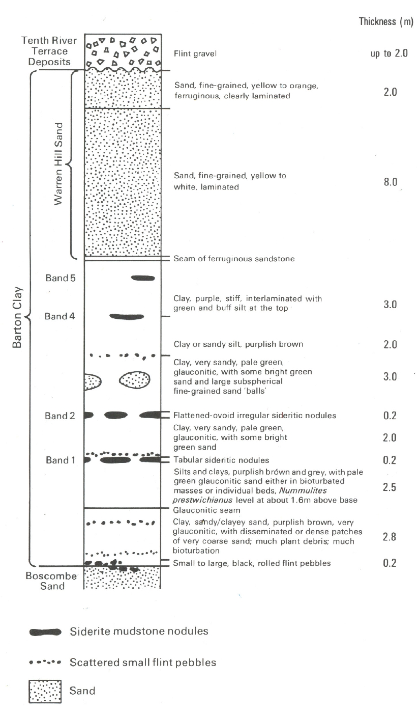
Above an erosion surface, the Barton Clay Formation is unusually sandy here. Its lower beds include sideritic ironstone horizons, while the Warren Hill Sand Member forms the upper sandy part. The section contains four sideritic horizons and a separate intervening sand-ball level, not five interchangeable ironstone seams.
Much younger river gravels cap the Eocene sequence. These deposits, cliff erosion and the legacy of ironstone working shape the modern headland. Hengistbury lies east of the Jurassic Coast World Heritage Site, although it has its own important nature-conservation and geological protections.

The detailed geological succession and important exposure limits at Hengistbury Head.
The headland records Eocene coastal sedimentation and much younger river gravels. Read this succession from oldest to youngest. Historical log thicknesses describe particular exposures, not current access or a continuous collecting face.
BRACKLESHAM GROUP
The lower exposed sands belong to the Bracklesham Group in the current BGS classification. Older memoirs and the GCR placed them within the Barton Group; their lithological observations remain useful, but that older grouping should not be reproduced.
Boscombe Sand Formation
Lutetian, middle Eocene. About 8 m is exposed locally, rather than the full regional formation thickness. Cross-bedded quartz sand and rounded flint gravel record a coastal, tidally influenced setting. Body fossils are reported absent from these sands at this locality; burrows are much more informative.
Age: Lutetian
Bituminous channel-margin sands
Sand containing plant-derived organic cement occurs beside a mud-filled channel; its locally deformed and eroded margins show that cementation began during deposition. The maximum reported development is 2.5 m. Unlined Thalassinoides pass into lined Ophiomorpha where the surrounding sand changes. These are sedimentary and trace-fossil observations, not evidence for an abundant seed bed.
Upper clean sand and T5 surface
The uppermost sand is clean and fine grained, locally above a pebble lag. The reported maximum is 1.25 m. T5 is a published sedimentary-cycle marker, not a formal member.
BARTON GROUP
The marine beds above the basal erosion surface belong to the Barton Group. The following lower sequence is a historical generalized section for the western end of Hengistbury, not a promise that each layer is continuously exposed today.
Barton Clay Formation
The local succession is unusually sandy compared with more offshore equivalents. Its lower part was formerly called the Hengistbury Beds, and is approximately 16 m thick; Warren Hill Sand is included within this formation. The formation-wide BGS age range is Lutetian–Bartonian. This does not date every local horizon individually.
Age: Middle Eocene; formation range Lutetian–Bartonian
Basal flint-pebble bed
Rounded black flints mark the boundary above Boscombe Sand. Thickness in the BGS generalized western section: 0.2 m.
Basal glauconitic sandy clay
Bioturbated, plant-bearing sandy mud with patches of coarser sand. A glauconitic seam marks its top. Thickness in the BGS generalized western section: 2.8 m.
Lower silt-and-clay interval
Brownish and grey muddy beds contain green glauconitic sand. The published Nummulites prestwichianus horizon lies about 1.6 m above the base of this interval, approximately 4.6 m above the formation base. Thickness in the BGS generalized western section: 2.5 m.
Nodule Band 1
Tabular sideritic concretions form the lowest labelled ironstone band. Thickness in the BGS generalized western section: 0.2 m.
Sandy clay above Band 1
Glauconitic pale-green sandy clay separates the two lower nodule bands. Thickness in the BGS generalized western section: 2.0 m.
Nodule Band 2
Flattened, irregular sideritic concretions form a second marker. Thickness in the BGS generalized western section: 0.2 m.
Sand-ball interval
Glauconitic sandy clay contains large rounded bodies of fine sand. These are soft-sediment structures rather than another ironstone bed. Thickness in the BGS generalized western section: 3.0 m.
Brown clay and sandy silt
A muddier interval overlies the sand-ball beds and precedes the upper stiff clays. Thickness in the BGS generalized western section: 2.0 m.
Upper clay with Bands 4 and 5
Stiff purple clay becomes interlaminated with green and buff silt upward. The generalized drawing places Band 4 near its base and Band 5 higher within it. These are marker labels in the historical log, not five continuous mineable ironstone seams. Thickness in the BGS generalized western section: 3.0 m.
Warren Hill Sand Member
Bartonian fine-grained sand, commonly laminated, forming the upper sandy part of the Barton Clay Formation. The formal type section is about 10 m thick; an older GCR summary gives 9 m. The BGS generalized log separates a lower 8 m pale sand from an upper 2 m more ferruginous sand. Neither value should be treated as a uniform headland-wide thickness.
Age: Bartonian
Basal ferruginous sandstone seam
A thin iron-cemented seam marks the transition into Warren Hill Sand in the generalized western log. No numerical thickness is supplied.
Lower laminated Warren Hill sand
Fine pale-yellow to white sand forms most of the member in the generalized western section.
Upper ferruginous Warren Hill sand
The upper portion is orange-yellow, iron-stained and laminated.
River-terrace gravel
An erosional surface separates much younger flint gravel from the Eocene succession. Figure 18 labels this Tenth River Terrace Deposits and shows up to 2 m, while another exact headland section records up to 3 m with a sand layer. Keep those different local measurements separate; the terrace label is the historical mapping terminology.
Age: Quaternary
References
Bcp Byelaws
Bcp Hengistbury
Bgs Barton Clay Lexicon
Bgs Boscombe Lexicon
Bgs Bournemouth
Bgs Hengistbury Figure18
Bgs Iow Modern
Bgs Warren Lexicon
Gcr Hengistbury
SAFETY
Keep clear of cliff faces and edges, avoid slippery rock armour and groynes, and check tide and weather before any beach approach. Never climb to a named layer or dig in sand faces. Use reserve paths where beach width is reduced. Check current local closures before visiting.
EQUIPMENT
Use a camera, hand lens and notebook. Hammers, sieves and sediment bags are unnecessary for an observation visit; any scientific sampling requires explicit land-manager authorisation.
CLEANING AND TREATING
For already lawfully held specimens, establish the horizon and source before cleaning. Do not wash fragile carbonaceous material or chemically treat siderite without specialist assessment. The old blanket seed-washing and airtight-storage recipe is not appropriate without knowing the preservation and deterioration mechanism.
IDENTIFY YOUR FINDS
Need help identifying a fossil? Share clear photos, where you found it and its size with the community.
FURTHER READING
Hengistbury Head GCR account
BGS Bournemouth memoir, local sections and Figure 18
BGS Boscombe Sand modern classification
BGS Barton Clay Formation
BGS Warren Hill Sand Member
BCP nature-reserve rules
BCP Hengistbury Head visitor information
ACCESS RIGHTS
The council’s published reserve rules prohibit taking plants, soil, stones and trees. Use the reserve for observation and photography. Obtain explicit land-manager authorisation for geological sampling; SSSI status or loose beach material does not create an automatic collecting right.
It is important to follow our ‘Code of Conduct’ when collecting fossils or visiting any site. Please also read our ‘Terms and Conditions’.
LINKS
♦ Fossil Discussions
♦ Fossil Articles
♦ Buy Fossils, Tools and Equipment
♦ Buy Crystals, Meteorites, and Artefacts
♦ Join Fossil Hunts
♦ UK Fossils Network