

Hope’s Nose and Daddy Hole reveal Devonian corals and stromatoporoid sponges in Torquay’s limestone coast. Their folded rocks record changing shallow-sea environments, while Hope’s Nose also preserves a much younger raised beach with fossil shells. Visit these two separate localities for observation and photography only, leaving fossils, rocks, minerals and living marine life in place. Steep ground, unstable cliffs and tidal ledges require careful planning and a safe viewpoint.
Hope’s Nose: locality photographs.


Daddy Hole: locality photographs.


FIND FREQUENCY: ♦♦♦ – Corals, stromatoporoids and other fossil structures can reward close observation of naturally exposed surfaces. This rating concerns visible features: all specimens are to remain in place.
CHILDREN: ♦ – The rocky fossil exposures are unsuitable as a children’s collecting area. Families should use suitable established paths and safer viewpoints, with close supervision near steep drops.
ACCESS: ♦♦ – Hope’s Nose involves a steep footpath from Ilsham Marine Drive. Daddy Hole has coastal-path viewpoints, but its shore and quarry exposures are separated by difficult, sometimes tidal terrain. Neither is an easy all-tide foreshore walk.
TYPE: Two separate protected coastal localities: cliffs, disused quarry exposures and rocky shore. Observe and photograph without removing specimens or altering the rock surface.
DIRECTIONS
♦ Hope’s Nose. Approach from Ilsham Marine Drive in Torquay and use the established footpath indicated by local signs. The council identifies this as the land access to the headland. Check parking restrictions and leave access clear. The descent and return climb are steep; the rocky shore is more demanding than the upper path.
♦ Daddy Hole. Approach the Meadfoot side of Torquay via Meadfoot Sea Road. The council’s Meadfoot Beach car park is on Daddyhole Road; check its current conditions. Daddyhole Plain also gives access to the signed Coast Path above the cliffs. From Torquay Harbour, reach the Coast Path via Parkhill Road.
♦ Triangle Point lies beside Daddyhole Cove towards Meadfoot Beach. Published shore exposures are separated by rough ground and tidal rocks. Use only an open, established approach with a clear return route. Do not climb over large boulders or descend an unstable slope simply because an old photograph or scientific log records an exposure there.
♦ Treat the localities as separate visits. Travel between them using roads and signed public paths, rather than attempting a continuous intertidal traverse. Stay with coastal-path viewpoints if the shore conditions are unsuitable.
♦ Locality coordinates: Hope’s Nose, 50.46347°N, 3.48159°W; Daddy Hole, 50.45556°N, 3.51283°W. These identify the geological localities, not car-park or footpath entrances. Check current maps, signs and notices before visiting.
FOSSIL HUNTING
Observation and photography only. Daddy Hole and Hope’s Nose are places to read fossils in the rock and build a photographic record. Leave fossils, loose stones, sediment, minerals and attached marine life where they are. Use already exposed surfaces, without hammering, levering, scraping, brushing, washing or enlarging an exposure. A close photograph paired with a wider view of its bed is more useful than an isolated close-up.
Daddy Hole: start with the limestone textures. In the old workings around Triangle Point, the pale-weathered surfaces reveal different kinds of coral-rich limestone. Branching tabulate corals such as Thamnopora appear as groups of narrow tubes or broken twig-like sections; solitary rugose corals may show a circular or oval section with radiating internal partitions. Crinoidal limestone contains abundant small skeletal discs and fragments. These fossils are embedded in hard limestone, and a visible section rarely preserves every feature needed for a species identification.
Daddyhole Cove: the basal shell-and-coral beds. The transition from shale to limestone is particularly important scientifically. Thin crinoidal limestones alternate with fossil-bearing shale containing branching bryozoan debris and the distinctive slipper-shaped rugose coral Calceola sandalina. Its local record belongs to the basal transition and immediately succeeding crinoidal beds, so it should not be expected in every quarry face. These are historical measured-section records, not an invitation to approach unstable faces or open fresh shale.
Triangle Point: contrasting coral communities. The lower part of the logged succession contains several thin Thamnopora-rich concentrations. Higher, some relatively coral-poor limestones give way to thicker fossil concentrations and to beds rich in Remesia and Scoliopora. Grypophyllum denckmanni is a recorded component of the prominent biostrome around 28 m above the base of the published Triangle Point log. A biostrome is a bed containing a concentration of organisms; many local colonies were toppled or broken, so a dense fossil layer need not be an intact reef.
Stromatoporoids are sponges, not corals. The rounded or bun-shaped masses on some bedding surfaces are stromatoporoids, extinct calcareous sponges. Naturally exposed sections can show closely spaced internal growth layers. At Triangle Point some have little tubes of Syringopora intergrown through them, while other fossils carry successive encrusting organisms. Photograph the whole mass as well as the fine structure: a colony’s shape, its orientation and the surrounding sediment all help explain how it grew and was buried.
Parson’s Hole and the Knoll are different records. The scientific section at Parson’s Hole includes Remesia-rich beds and higher laminar Planocoenites, Alveolites and stromatoporoid growths. The Knoll instead preserves a substantial shale interval with sparse crinoids, brachiopods and bryozoans. Some of the Parson’s Hole section was inaccessible even when logged. These records explain the locality’s variety; they do not imply that every recorded bed is safely visible on a visit.
Hope’s Nose: the northern quarry limestone. The old quarry contains more massive coral-and-stromatoporoid limestone. Published observations identify Mesophyllum, Acanthophyllum, Cyathophyllum, Heliolites, Alveolites and Thamnopora, together with bun-shaped stromatoporoids, some overturned during deposition. Treat these as the documented assemblage rather than a checklist that every visit will reveal. The thinner, folded limestone below the southern raised beach is a separate exposure and should be photographed and labelled separately.
Hope’s Nose: a much younger fossil beach. The cemented sands above the Devonian bedrock contain Pleistocene marine shells. Broad, irregular oyster valves of Ostrea edulis are especially characteristic, with periwinkles, limpets and other gastropods recorded in scientific samples. These shells are enormously younger than the Devonian corals beneath them. Sand deposited by wind above the beach also contains reworked marine shell debris, so a marine shell on its own does not demonstrate that its enclosing layer formed under the sea. Inspect only naturally exposed material from a safe position; the section must not be sampled or cleaned.
Tiny fossils and historic specimens. The raised-beach study also recovered minute foraminifera and two ostracod valves, while the dune sand yielded four specimens of the land snail Pupilla muscorum. Such laboratory records are not a promise of recognisable fossils in casual photographs. Hope’s Nose also has a historic brachiopod type specimen catalogued as Renssellaeria striatissima in the Sedgwick Museum; its exact bed is not recorded. Keep any photographic identification no more precise than the evidence permits.
Separate fossils, minerals and living animals. Calcite veins can cut across the Devonian bedding and belong to a later mineralisation history. They are not coral branches, and their scientifically important mineral contents should be left untouched. The Devonshire cup coral, Caryophyllia smithii, is a living marine animal rather than a Devonian fossil. Do not disturb living colonies, shells or rock-pool communities while photographing the geology.
Hope’s Nose: fossil photographs.


Daddy Hole: fossil photographs.


A chronological record of fossil discoveries, geological research and conservation milestones at Hope’s Nose and Daddy Hole.
1834–1835 – Hope’s Nose raised beach enters the scientific record
Robert Austen, later known as Godwin-Austen, presented an account of the raised beach in November 1834; it was published in 1835. Recognition of marine shell-bearing deposits above the present shore made the site an early reference point for investigating former sea levels.
1874 – Daddy Hole’s fold and basal coral beds described
Arthur Champernowne described the repeated limestone and shale succession around Daddy Hole, using the matching beds and occurrences of Calceola sandalina to investigate the contorted structure. The work established the importance of the shale–limestone passage and its fossils long before the modern measured logs.
1882 – A Hope’s Nose brachiopod enters the type record
Thomas Davidson’s brachiopod work figured the Hope’s Nose specimen now catalogued as the holotype of Renssellaeria striatissima, held in the Sedgwick Museum as H 4342. The museum record associates it with G. F. Whidborne, but gives no collector or exact fossil bed; the publication year is not a verified date of discovery.
1888 – A new ostracod from Daddyhole Knoll
T. Rupert Jones described the new ostracod genus and species Kyamodes whidbornei, with a geological note by G. F. Whidborne. The material came from a thin limestone band in the quarry on Daddyhole Knoll, associated with Athyris concentrica and a doubtful gastropod identification. Its historical bed cannot safely be equated with a numbered horizon in the later logs.
1892 – Microscopy reveals contrasting limestone fabrics
E. Wethered examined limestones from Daddy Hole and Hope’s Nose, recognising the contribution of coral debris and other skeletal material. At Hope’s Nose his thin sections distinguished massive bioclastic rock, coral-rich intervals, dark beds with crinoids and ostracods, and finer crystalline upper beds, adding a microscopic view to the visible quarry sections.
1903 – Detailed Survey sections compare the two headlands
W. A. E. Ussher documented the Daddy Hole shale–limestone passages and the massive and thin-bedded limestones at Hope’s Nose, illustrating folds, faults and volcanic tuffs. His discussion shows how uncertain early interpretations of the irregular limestone contact were; later studies revised the stratigraphic framework rather than simply reproducing a uniform succession.
1922 – Native gold reported at Hope’s Nose
W. T. Gordon reported native gold in calcite veins cutting the Devonian limestone. The occurrence began a separate strand of research into the headland’s younger mineralisation, distinct from its coral-rich marine beds and Pleistocene shell deposits.
1929 – Gold-bearing veins described in detail
Arthur Russell published a detailed account of the gold-bearing calcite veins and their delicate branching gold. This established the character of the unusual occurrence and provided a basis for later analytical studies of its precious-metal minerals.
1933 – Raised-beach shell records consolidated
Wilfred Lloyd brought together earlier shell records in the revised geological account of the Torquay district. The Hope’s Nose list became an important comparison for later sampling, which distinguished historic records from specimens newly recovered and revised the interpretation of the former marine environment.
1977 – Daddyhole limestone placed in a formal local succession
Colin Scrutton’s study established named units for the Torquay limestone succession and examined their changing coral faunas and environments. Daddyhole became the basal named limestone division, with its type passage defined at Daddyhole Cove; modern usage gives it member rank within the Torquay Limestone Formation.
1982 – Palladium-bearing minerals recognised
Analytical work by A. M. Clark and A. J. Criddle identified palladium-bearing gold and isomertieite at Hope’s Nose. Associated material was tentatively compared with mertieite-II. Further work on the carbonate veins investigated their textures and saline, relatively low-temperature mineralising fluids.
1984 – Daddy Hole coral communities and measured sections analysed
Kevin Goodger, Anthony Buglass and Colin Scrutton published separate logs for Daddyhole Cove, Triangle Point, the Knoll and Parson’s Hole, correlated cautiously with Dyer’s Quarry. Their analysis linked changing coral and stromatoporoid associations with carbonate shoals, intermittently exposed surfaces, restricted shallow water and more open-marine conditions. The Knoll shale and its tuff provided an important, though tentative, correlation with Parson’s Hole.
1986 – Hope’s Nose protected within an enlarged SSSI
Hope’s Nose to Walls Hill was notified under the Wildlife and Countryside Act, amending an earlier site by extension and deletion. Its cited geological interests include the Devonian limestone facies, mineralised veins, raised-beach fossils and major fold-and-thrust structures. The designation had an earlier partial origin in 1952.
1987 – An eleven-unit raised-beach history established
D. N. Mottershead, D. D. Gilbertson and D. H. Keen distinguished eleven sediment units at Hope’s Nose and reassessed the marine and terrestrial fossils. Their work separated beach, dune, weathered sand and slope deposits, questioned simple correlations based on height alone, and supported an older interglacial age for the Hope’s Nose beach than for Thatcher Rock.
1988 – Daddyhole designated for its geology and wildlife
Daddyhole was notified as a new Site of Special Scientific Interest. Its type limestone section, coral fauna, desiccation cracks, shale–limestone facies and large recumbent fold were central geological reasons for protection.
1990 – An unusual selenide assemblage documented
C. J. Stanley, A. J. Criddle and D. Lloyd described precious- and base-metal selenides in the Hope’s Nose carbonate veins. The assemblage expanded the scientific significance of the locality beyond native gold and showed that its mineral history involved a distinctive association of selenium and metals.
1998 – Chrisstanleyite described from Hope’s Nose
Werner Paar and colleagues described chrisstanleyite, a new silver–palladium selenide, from Hope’s Nose material obtained for study in 1995. The holotype was deposited in Salzburg and cotype polished sections in the Natural History Museum, London. Its description made Hope’s Nose the type locality for a newly recognised mineral.
1998 – Raised-beach significance consolidated for conservation
The geological conservation account presented Hope’s Nose as a key record of Pleistocene environmental and sea-level change. It related the marine beach to an older interglacial episode and distinguished the later dune and head deposits, while stressing the value of the fossil assemblages and sedimentary relationships.
2003 – Revised mapping adopts the modern limestone hierarchy
The geological account of the Torquay district used Daddyhole Member within the Torquay Limestone Formation and described the headland’s massive-to-thin-bedded facies changes, local tuffs and conodont age evidence. It also placed the folds, thrusts, raised beach and mineralised veins within a wider geological framework.
2021 – Geoconservation review highlights contrasting exposures
Malcolm Hart and Christopher Smart illustrated the coral- and stromatoporoid-bearing limestone at Triangle Point and the northern Hope’s Nose quarry, alongside the folded, ash-bearing beds below the southern raised beach. Their account emphasised how fossil growth, sedimentary disturbance and later deformation all contribute to the features visible today.
GEOLOGY
The two headlands preserve complementary parts of Torquay’s geological history. Their coral-rich bedrock belongs to the Eifelian Stage of the Middle Devonian and is assigned to the Daddyhole Member of the Torquay Limestone Formation, within the Tamar Group. It records the early development of a shallow carbonate platform on the Torquay High. Crinoids, tabulate and rugose corals, stromatoporoids and other animals supplied much of the carbonate sediment, but their distribution changed markedly between environments and through time.
At Daddy Hole, the change from muddy seabed to carbonate platform is preserved in the shale–limestone transition of Daddyhole Cove. Crinoid-rich grainstones were followed by limestones rich in tiny rounded carbonate grains, called peloids, and then by mixed peloidal and skeletal packstones. Desiccation cracks at several levels show that parts of the platform became exposed to air. Thin coral-rich beds interrupt the succession, and the fossils include both colonies that grew locally and material disturbed or redistributed before burial.
The later history differs across the Daddy Hole exposures. At the Knoll, a tongue of shale interrupted carbonate accumulation, probably following local subsidence near the platform margin. Parson’s Hole preserves limestone at a broadly comparable level and then increasingly important laminar coral and stromatoporoid growth. Their large size and intergrowths have been interpreted as a possible local mound, but its original relief cannot be demonstrated from the available exposure. The often-quoted 125 m type succession is a composite that also includes Dyer’s Quarry; it is not a single continuous thickness visible at Daddy Hole.
At Hope’s Nose, more massive limestone in the northern old quarry contrasts with the thinner beds below the southern raised beach. The massive and thin-bedded facies have complicated, locally erosional relationships, rather than forming a uniform layer-cake succession. Thin graded volcanic-ash beds occur among the southern limestones. Mudstones historically called the Eifelian Shales or Nordon Formation and the older, undivided Meadfoot Group also occur in the promontory’s faulted blocks. The modern Saltash Formation embraces the historical Nordon terminology, but its broad regional age range cannot be applied to one local exposure.
Later Variscan compression folded, cleaved and faulted the Devonian rocks. Daddyhole Cove lies in the softer shale core of a recumbent fold, with limestone on its upright and overturned limbs. Hope’s Nose likewise shows strongly folded limestone and a low-angle thrust; beds may be inverted, and repeating rock types do not necessarily represent successive episodes of deposition. Mineralised fractures at Hope’s Nose were filled later by carbonate-rich fluids, producing calcite and dolomite veins with an unusual gold, palladium and selenium association. Their age and fluid source remain interpretations rather than directly observed depositional facts.
An immense time gap separates the Devonian rocks from the Pleistocene raised beach at Hope’s Nose. Waves cut a platform and cliff into the older limestone; angular debris, beach boulders, shelly sand and wind-blown sand then accumulated against this relief, followed by further slope deposits. Amino-acid studies have traditionally correlated the marine beach with Marine Isotope Stage 7, approximately 200,000 years ago. The overlying dune and head deposits belong to a more complex later history. Their contacts, weathering and reworked fossils matter as much as their height above today’s sea, and the eleven-unit measured log is more informative than treating the entire exposure as one raised-beach layer.

Hope’s Nose: geology photograph.

Daddy Hole: geology photograph.
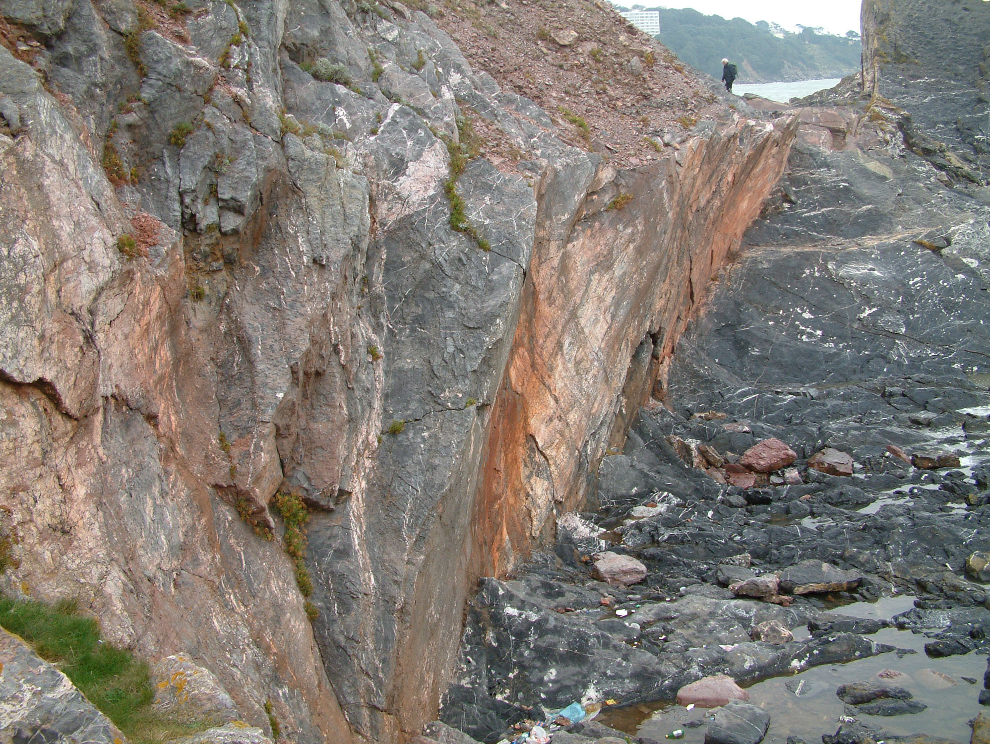
Detailed geology of Hope’s Nose and Daddy Hole, with separate Devonian sections and the Hope’s Nose raised-beach succession.
How to read these sections. The Devonian local sections below are described upwards, using the individual bases of the published logs. Daddyhole Cove, Triangle Point, the Knoll and Parson’s Hole are separate exposures; no continuous 125 m stack is implied. The Hope’s Nose Quaternary units are then described from the rock platform upwards using the eleven-unit 1987 scheme. Faults, lateral changes and inaccessible intervals prevent a neat bed-for-bed join between every exposure.
MEADFOOT GROUP
Hope’s Nose: older clastic rocks, undivided. Fault-bounded Lower Devonian rocks occur in the promontory. The Torquay succession is described as grey to dark-grey silty mudstone with sandstone layers and occasional thin bioclastic limestone; shelly fossils support an Emsian age. These are older than the coral-rich limestones. The group has not been reliably divided into formations in Torquay, and a Staddon Formation assignment is not demonstrated here. No regional sandstone thickness or fossil list is used as a measured Hope’s Nose bed.
Hope’s Nose quarry fault: historical fossiliferous clastic bands. Near the faulted junction of dark slate and quarry limestone, decomposed fossil-bearing bands and siliceous limestone yielded fossils listed as Pleurodictyum problematicum, Zaphrentis, Homalonotus roemeri ?, Spirifera primaeva and Strophomena rhomboidalis var. analoga. Ussher placed this record under the Meadfoot Beds while warning that the regional distinction from the old Staddon grits was often uncertain. This exact fault-adjacent record is separate from the lists for Hope Farm, the New Drive and other nearby exposures.
TAMAR GROUP
Saltash Formation
Hope’s Nose: historical Nordon Formation / Eifelian Shales. The local muddy succession above the undivided Meadfoot rocks was mapped as the Nordon Formation. Grey mudstone weathers grey-green or buff; fine siltstone laminae and thin beds are more frequent low in the succession, and reddish-grey muddy limestone lenses occur towards its top. An Eifelian age was inferred from its shelly fauna, historically including Spirifer speciosus. The current Saltash Formation entry includes Nordon among its former names. This naming change does not make the whole regional Saltash age range or its north-Cornwall thickness applicable to Hope’s Nose.
Daddyhole Cove: shales beneath the limestone. Grey Eifelian shales lie in the core of the recumbent anticline and are more readily eroded than the surrounding limestone, helping to form the cove. They contain crinoidal remains, brachiopods and bryozoans; reddening near the limestone is prominent in historical descriptions. The base of the Daddyhole carbonate unit is taken at the first of the limestone–shale transition beds described below, rather than at an invented sharp change from entirely unfossiliferous mudstone.
Torquay Limestone Formation
Daddyhole Member
Age, historical rank and composite limits. The Daddyhole Member is Eifelian. Older works used “Daddyhole Limestone Formation” within a “Torquay Limestone Group”; these are historical ranks for the limestone discussed here. The detailed 1984 study assembled an approximately 125 m composite using the Daddy Hole exposures and Dyer’s Quarry farther west, with tentative links between some logs. Its whole-composite coral totals and youngest Dyer’s Quarry beds must not be treated as a record from this guide’s Daddy Hole exposures alone.
Daddyhole Cove: basal transition, about 5 m. On the western side of the cove, limestone beds 50–150 mm thick alternate with shale. The limestones are coarse crinoidal packstones, while the shale carries conspicuous bryozoan fragments and scattered corals, especially Calceola sandalina. Many of these slipper-shaped corals lie flat-face-down, interpreted as approximately their growth orientation. Alveolites also occurs in the shale interbeds and underlying shale. The intercalation records carbonate debris spreading into an area where mud had previously accumulated.
Daddyhole Cove: succeeding crinoidal limestone. Well-bedded crinoidal grainstones overlie the transition. The same lower part of the limestone succession is repeated on the overturned fold limb, where roughly 45 m was examined around the Knoll and Triangle Point. That structural repetition does not double the true stratigraphic thickness, and the first beds at Triangle Point are not a complete duplicate of the cove transition.
Triangle Point: basal omission and correlation. Triangle Point is faulted against the Knoll. Erosion has removed the basal 5 m of limestone–shale interbeds at its western end. Even over this short distance, individual biostromes cannot all be matched confidently with those in Knoll Quarry, and some die out along strike. The published Triangle Point succession has three broad facies packages: crinoidal grainstone, peloidal grainstone and peloidal–bioclastic packstone. They are descriptive divisions, not separately named formal members.
Triangle Point: crinoidal grainstones and six coral-rich horizons. The lower package consists predominantly of grainstone made from crinoid debris. Six biostromes in its middle and upper parts are dominated by broken branches of Thamnopora, with sparse solitary rugose corals and, at some levels, tabular or domal stromatoporoids. Alveolites and Cladopora accompany the association, with Striatopora tenuis concentrated at one horizon. The paper does not assign these six beds a usable numbered bed scheme, so their positions are not converted into invented bed numbers.
Daddyhole Cove and Triangle Point: solitary-coral association. A ptenophyllid association extends from Daddyhole Cove to about 35 m above the Triangle Point log base. It contains Acanthophyllum and/or Grypophyllum, with Lekanophyllum, Cystiphylloides and Digonophyllum varying between horizons. Below about 17 m on Triangle Point, these solitary corals are sparse and mainly associated with thin Thamnopora biostromes. Grypophyllum becomes the leading rugose element higher in the section, with G. denckmanni particularly prominent in the figured biostrome near 28 m. These are overlapping fossil ranges within the limestone packages, not additional beds.
Triangle Point: desiccated surface at about 7.5 m. A cracked surface within the crinoidal succession records temporary emergence. The surrounding grainstones were interpreted as shoal deposits accumulated at or above normal wave base, with intervals of local coral colonisation and some transported skeletal material. This early cracked horizon is distinct from the two higher cracked levels in the packstones.
Triangle Point: peloidal grainstones. The middle package is dominated by small rounded carbonate grains. Thin beds commonly fine upwards from crinoidal bases; occasional channel-shaped bases indicate local erosion and redistribution. Corals are scarce through much of this interval. Gastropods, bivalves, ostracods and some brachiopods were interpreted as the resident fauna, while peloids may include faecal pellets. The setting was very shallow subtidal to intertidal.
Triangle Point: possible charophytes near 23 m. Small objects at about 23 m above the published section base were tentatively identified as charophyte oogonia. Their interpretation remains uncertain; if correct, they may have been washed from a nearby brackish lagoon. They are not a demonstrated freshwater plant bed, nor evidence that the whole limestone was deposited in fresh water.
Triangle Point: upper 2 m of the peloidal grainstones. Auloporid coral fragments become conspicuous near the top of the otherwise coral-poor grainstone package. Above, intraclasts and occasional low-angle cross-bedding indicate shallow channel activity. Scattered Remesia colonies and other coral debris record changing conditions before the prominent biostromes of the overlying packstones.
Triangle Point: lower of the paired thick biostromes, about 1 m. At the base of the peloidal packstones is the lower of two prominent coral-and-stromatoporoid beds. Its fauna resembles the earlier Thamnopora association. Colonies are commonly disoriented, but some fragile branched material remained large, suggesting that much of it was not carried far. Extensive encrustation indicates intervals of limited net sediment accumulation before final burial.
Triangle Point: intervening packstone, about 0.70 m. A short packstone interval separates the two approximately metre-thick biostromes. Its presence matters: the pair should not be collapsed into a single 2 m fossil bed. The study gives this separation but does not supply an independently named bed or a distinct diagnostic fossil assemblage for it.
Triangle Point: upper thick biostrome, about 1 m. The lower part retains the earlier coral association, whereas the upper part contains more Scoliopora and locally abundant Remesia, fewer rugose corals, and many stromatoporoids intergrown with Syringopora. These faunal changes were interpreted as a shift towards somewhat more restricted conditions, followed by disruption and burial, possibly during storms.
Triangle Point: figured biostrome at about 28 m. The study’s photographs specifically locate a roughly metre-thick biostrome at about 28 m above the Triangle Point section base, with encrusted Thamnopora and conspicuous Grypophyllum denckmanni. This figured record belongs to the prominent biostrome interval already described; it is not an additional bed to add to its thickness.
Triangle Point: overlying packstones, about 2.5 m. Peloidal packstones contain small burrows, fenestrae, high-spired gastropods, ostracods, and nodular or encrusting algae. Two distinct desiccation-cracked levels occur in this interval. Their association with a restricted, non-coralline fauna supports intermittent intertidal exposure after the burial of the thick biostromes. The individual cracked surfaces were not given separate measured thicknesses or formal bed names.
Triangle Point: higher bioclastic packstones and thin biostromes. Remesia debris, partly intact colonies and occasional whole colonies are conspicuous in the upper part of the section, often accompanied by Scoliopora and less commonly Thamnopora. Several thinner biostromes occur. One forms a prominent bedding surface at the eastern end, bearing globular stromatoporoids up to about 600 mm across, many with Syringopora intergrowths. The 600 mm measurement is a fossil diameter, not bed thickness.
Triangle Point: stromatoporoid-bearing interval, approximately 12–35 m. Domal to vertically discoidal stromatoporoids characterise several rudstones and floatstones in this height range, mostly disoriented. Tabular forms occur in the lower 12 m; Syringopora intergrowths are particularly associated with the higher Scoliopora assemblage. The digitate stromatoporoid Stachyodes is usually occasional but becomes prominent in the thick rudstone–floatstone near 30 m. These overlapping fossil ranges describe beds already included above, rather than extra units to add to the log.
Triangle Point: upper limestone–shale transition. The top of the logged succession alternates peloidal and bioclastic packstone with thin shale partings. This introduces the transition towards the more substantial shale interval exposed at the Knoll. Lateral changes and the intervening fault prevent a precise matching of every bed.
Triangle Point: the 2021 account of coral mounds. A later geoconservation account describes small, separated coral mounds on the old quarry floor, with skeletal debris between them, rather than a continuous barrier comparable with a large modern coral reef. It lists Mesophyllum, Acanthophyllum, Calceola, Thamnopora and Alveolites. This is a general site description, not a revised bed-by-bed distribution; the detailed basal provenance of Calceola in the measured sections remains distinct.
Triangle Point: dark rudstones and shell-rich interbeds. The same account distinguishes dark rudstones interpreted as debris flows from higher parts of the carbonate build-up. Interbedded limestone contains concentrations of brachiopods or turreted gastropods. These observations add information about disturbed skeletal sediment and shell-bearing beds without supplying a new measured thickness or a replacement numbering scheme.
Triangle Point: stromatoporoids on the prominent bedding plane. The 2021 description records numerous bun-shaped stromatoporoids less than 40 cm across on the prominent exposed plane, some intergrown with narrow-tubed Syringopora. This is a separately reported set of observations. It does not replace the 1984 report of examples up to 600 mm, and the two measurements are not combined into a new universal size limit.
Triangle Point: intervening auloporid and brachiopod limestone. Intervening limestone beds are described as rich in Aulopora and brachiopods, some showing geopetal structures. Such partly filled cavities preserve evidence of the original direction of gravity in the sediment and are useful when interpreting subsequently tilted or overturned limestone. The description is retained separately from the measured-log Remesia and Scoliopora assemblages.
The Knoll: lower mixed packstones. Bioclastic packstones alternate with reddened peloidal packstones. These are distinct from the subsequent fine bivalve-bearing limestone and from the overlying dark shale. Similar facies occur at the top of Triangle Point, but the source’s correlation is approximate.
The Knoll: fine bivalve-bearing packstone, about 3 m. This comparatively fine limestone unit succeeds the interbedded packstones and precedes the main shale interval. Bivalves are its specified fossil component. It must not be absorbed into the shale thickness or replaced by a general coral-limestone description.
The Knoll: historical “Knoll Shale”, about 25 m. Dark-grey shale contains sparse crinoid ossicles, brachiopods and bryozoans. It forms the slope above Triangle Point and was named the Knoll Shale Member in the 1984 study. Here that name denotes the authors’ local shale interval, not a second modern member nested within the Daddyhole Member. The shale was interpreted as renewed muddy deposition at a locally subsiding carbonate-platform margin. It is absent on the western upright limb of the anticline.
The Knoll: tuff about 20 m above the shale base, 200 mm thick. A thin volcanic-ash layer occurs within the shale, leaving roughly 5 m of the quoted shale interval above it. The tuff was tentatively correlated with a similarly thick bed low in the Parson’s Hole section. The proposed equivalence is not a proven time line, and contrasting compaction and sedimentation rates complicate matching limestone with shale.
Parson’s Hole: lower packstones, approximately 10 m. Interbedded bioclastic and peloidal packstones contain conspicuous Remesia, with high-spired gastropods in some beds. Thin shale partings occur below the tuff. The facies resemble the upper Triangle Point limestone, but their individual section bases differ. Lower Parson’s Hole also contains Scoliopora and increasingly abundant Thamnopora; solitary rugose corals are generally sparse.
Parson’s Hole: tuff near 9 m, 200 mm thick. This volcanic bed lies about 9 m above the base of the western Parson’s Hole log. It is only a tentative counterpart of the tuff within the Knoll shale. No 25 m shale package is inserted here, because the measured Parson’s Hole section is predominantly limestone at the proposed equivalent level.
Parson’s Hole: upper approximately 5 m of the lower coral-bearing interval. The original description singles out an upper, roughly 5 m portion containing unbroken Remesia on bedding planes, levels rich in Thamnopora and Scoliopora, and scattered stromatoporoids, some encrusting tabulate corals. Its precise bounds are uncertain in the text and figure, so this subdivision is not assigned a fixed 5–10 m height range or added as another 5 m to the section. The independently located photographed examples are given below.
Parson’s Hole: coral concentrations around 10–11 m. Photographed examples locate a Thamnopora reticulata branch-fragment biostrome at about 10 m and Remesia tubaeformis colonies at 10.5 and 11 m above the local log base. Bedding surfaces also carry unbroken colonies, Scoliopora and scattered stromatoporoids, including examples encrusting tabulate corals. These specific figured records are kept separate from a claim that every coral species in the composite study occurs at this level.
Parson’s Hole: grainstone unit, about 2 m. A grainstone interval separates the lower coral-bearing packstones from the thick, less clearly bedded sequence above. It is a distinct lithological break in the local succession. Minor faulting and shearing higher in the section make absolute thickness measurements less secure.
Parson’s Hole: lower laminar bindstones. Alveolites and then Planocoenites become prominent in the partly inaccessible higher limestone. Near 22–24 m, figured material shows thin Planocoenites gradatus layers with Cladopora vermicularis branches, bryozoan debris, interleaved tabular stromatoporoids and an Alveolites cap. Stringophyllum first appears at about 22 m; the study identifies S. buechelense, chiefly associated with Lekanophyllum cylindricum, in this broader association.
Parson’s Hole: upper stromatoporoid–coral bindstones. Tabular stromatoporoids become more important upwards, with Alveolites and a reddish, partly dolomitised skeletal wackestone–packstone matrix. Individual stromatoporoid skeletons reach at least 2 m in diameter. The Alveolites association includes A. minutus, Planocoenites gradatus and Cladopora vermicularis, with occasional Thamnopora; scattered Heliolites porosus is also recorded at Parson’s Hole. These comparatively open-marine, less turbid conditions may have supported a local mound, but its relief and a complete thickness cannot be established from the exposure.
Separate historical logs: Ussher’s Daddy Hole sections (1903). The early Survey account describes two descending successions, reproduced here in their original top-to-bottom order. They record named parts of the locality, but their individual beds have not been securely matched to the later measured logs. Their shale-to-limestone schemes cross the modern formation/member boundary; the old slate intervals are not all part of the Daddyhole Member. Historical fossil names and feet are retained where significant; they do not establish current species identifications or additional strata to append to the 1984 succession.
Daddy Hole: Champernowne’s historical fossil comparisons. The 1874 description records Atrypa reticularis in the cove shale and Cystiphyllum with Calceola sandalina in the passage towards limestone. Comparisons of limestone exposures on the two sides of the cove used the historical names Murchisoniae, Favosites and Syringopora, including observations at Triangle Point. These are nineteenth-century identifications. The detailed 1984 study specifically reported no Favosites in its Daddyhole limestone material, so the older name cannot simply be carried into a modern confirmed checklist.
Under Daddyhole Plain: historical bed 1. Thick-bedded grey limestone forms the upper part of this descending section. No separate thickness is supplied for it in the historical log.
Under Daddyhole Plain: historical bed 2, about 15 feet. Irregular, thin-bedded grey limestone is locally slaty or shaly and contains buff earthy material. The quoted 15 feet is the thickness of this historical package, not a revised thickness for a particular Goodger bed.
Under Daddyhole Plain: historical bed 3. Dark-grey slate, weathering greenish, contains limestone lenses and fragments of corals and crinoids. This transitional package precedes the lowest slate interval in the original descending account.
Under Daddyhole Plain: historical bed 4. Dark-grey slate, weathering greenish and cut by calcite veins, is locally very fossiliferous, particularly at approximately 30 feet below the limestone. In part of Daddyhole Cove the slate was described as reddened through roughly 40 vertical feet over a breadth of about 20 yards. These figures refer to a fossil position and an area of colour alteration, not separately measured sediment-bed thicknesses.
Daddyhole Cove: separately dated 1888 fossil record. Ussher recorded that Frech obtained Monticulipora allied to M. fibrosa, Calceola sandalina, Pentamerus galeatus and Cyrtia whidbornei in Daddyhole Cove in 1888. The affinity qualifier for Monticulipora is retained. The record is a historical local assemblage, not a demonstrated species list for one of the later numbered horizons.
East side of Daddyhole Knoll: historical bed 1. The top of this separate descending section is thick-bedded bluish-grey limestone. It is followed by thinner and more irregular limestone beds.
East side of Daddyhole Knoll: historical bed 2. Rather thin, irregularly bedded dark-grey limestone lies below the thick-bedded upper unit. Its thickness is not stated.
East side of Daddyhole Knoll: historical bed 3. Red shaly limestone and partly calcareous shale contain Calceola sandalina, with fossils listed historically as Phacops, Atrypa, Leptaena, Orthis, Spirifera and Fenestella. These old generic identifications are not a modern re-identification of the specimens.
East side of Daddyhole Knoll: historical bed 4. Dark-grey shale contains occasional limestone beds and small limestone lenses. The fossils were recorded as Spirifera resembling S. speciosa and Fenestella. The resemblance qualifier is retained.
East side of Daddyhole Knoll: historical bed 5. Dark-grey and greenish shales and slaty beds contain calcareous patches. Lower in the succession the slates become very dark grey or blackish, with harder mudstone bands and lenses and signs of paler, slightly coarser interlamination. No complete thickness is established by this description.
Daddyhole Knoll: historical ostracod-bearing limestone band. The 1888 account summarised by Ussher places numerous Kyamodes whidbornei in a thin limestone band within a limestone–shale alternation below thick-bedded grey limestone in the Knoll quarry. Athyris concentrica and a doubtful Vermetus were reported from the same bed. The small fossil-bearing band remains a separate historical provenance record; it has not been securely equated with the later 3 m bivalve-bearing packstone or another numbered horizon.
Hope’s Nose: more massive northern limestone. The northern quarry and adjacent rocky platform expose thick or massive, locally lenticular limestone rich in corals and stromatoporoids. The documented northern-quarry genera include Mesophyllum, Acanthophyllum, Cyathophyllum, Heliolites, Alveolites and Thamnopora. Some bedding surfaces carry disturbed, bun-shaped stromatoporoids up to about 65 cm across. This diameter describes individual fossils; it is not a bed thickness.
Hope’s Nose: irregular transition to thinner limestone. Massive limestone passes laterally and upwards into thinner, darker and locally shaly beds across an irregular discontinuity, described as disconformable in the geological accounts. Erosion close to the time of deposition is an important feature of the old quarry. Folding and faulting complicate the present geometry, and the contrast between massive and thin-bedded facies should not be converted into a single continuous modern measured log.
Hope’s Nose: southern thin-bedded limestone. Below the raised-beach area, limestone beds are strongly folded and cleaved. Calcareous mudstone and thin tuffs occur within the Daddyhole succession. A published conodont assignment to the early Eifelian Polygnathus costatus partitus Zone provides a biostratigraphic constraint, but it is not a licence to give every photographed limestone surface an exact zonal position. The large overturned fold is displaced by a low-angle thrust.
Hope’s Nose: graded volcanic-ash beds. The southern thin-bedded limestones include a small number of graded, water-laid ash beds up to about 12–15 cm thick. Their grading records settling of volcanic material through water. Historical work also described two tuff bands separated by about 2 feet, but that older observation is not used to assert that every ash bed in the modern exposure belongs to a single precisely correlated pair.
Hope’s Nose: historical shale section (1903). Ussher estimated about 180 feet of “Eifelian slates” above the Lower Devonian rocks, conditional on the succession not being partly removed by thrust faults. Low in the section were blackish slates or shales with mudstone bands and lenses and occasional dark limestone. Higher beds were partly calcareous, locally fossiliferous and capped by buff-weathering slaty limestone. This conditional historical estimate is not a modern measured thickness for the Saltash Formation.
Hope’s Nose quarry: historical massive limestone exposure. Massive or thick-bedded, pale-grey and locally pinkish limestone was exposed through about 30 feet in the old quarry. Ussher listed Stromatopora, Heliolites porosus, simple Cyathophylla and Cystiphyllum vesiculosum, and discussed the limestone’s interpretation as a reef. These are the historical identifications, without an asserted modern synonymy. The quoted depth is the exposure then seen, not the total thickness of the member or a guarantee of its present visibility.
Hope’s Nose quarry: historical thin-bedded cover, about 12–20 feet. Thin, dark-grey limestone lay irregularly above the massive quarry limestone and continued towards the raised-beach area as thin or slaty beds. The uneven junction was debated as either a depositional relationship over an irregular reef surface or a feature influenced by deformation and inversion. Later descriptions of erosional facies changes and structural complication do not turn this old range into a uniquely correlated modern bed.
Hope’s Nose: historical pair of volcanic tuffs. In folded slaty limestone below a thrust, the early Survey account described two tuff bands, respectively about 8 and 6 inches thick, separated by about 2 feet and traceable for roughly 60–70 yards. These are the dimensions of that historical pair, with the last value representing lateral extent. They are preserved separately from the modern description of graded ash beds up to 12–15 cm thick; no exact bed-for-bed equivalence is assumed.
Hope’s Nose: historical shaly-limestone coral and bryozoan list. For the partly decalcified, fossiliferous shaly or slaty limestone, the early Survey account listed Cyathophyllum heterophyllum, Heliolites porosus, Fenestella arthritica, Hemitrypa oculata and Rhabdomeson ? similis. The question mark belongs to the historical identification and is preserved. These names are reported as the older identifications, without a modern species revision.
Hope’s Nose: historical shaly-limestone brachiopod list. The same account records Athyris concentrica ?, A. rugata, Atrypa aspera, A. desquamata, A. reticularis, Bifida lepida, Kayseria lens, Leptaena interstrialis, Orthis arcuata, Pentamerus galeatus, Productus pustulosus ?, P. subaculeatus, Rhynchonella parallelopipeda, R. procuboides, Spirifera curvata (described as the typical shape), S. speciosa and Streptorhynchus umbraculum. Doubtful determinations remain doubtful. This list combines material identified by different workers and does not establish that every species came from one bed.
Hope’s Nose: historical gastropods and separate shale reports. Two gastropods in the shaly-limestone list were named Platystoma sigmoidale and Scoliostoma (Turbo) texatus, retaining the published spelling. A separate statement says that Phacops latifrons was reported abundant in shale above the limestone; it is not a newly verified abundance estimate. The same survey reported no Calceola sandalina from the Hope’s Nose slates or limestones it examined. That historical non-record is not proof that the coral could never occur there.
Hope’s Nose quarry: historical petrographic observations (1892). Microscopic work reported by E. Wethered and reproduced in the 1903 memoir distinguished several parts of the old quarry. These descriptions are retained as an older petrographic record; their positions have not been tied securely to each later logged bed. Wethered also examined Daddy Hole material and recognised the importance of accumulated coral debris at both localities.
Historical quarry base: massive skeletal limestone. Thin sections from the massive limestone at the quarry base showed broken calcareous fragments whose original biological structure had largely been lost. This is evidence of both skeletal debris and later alteration, rather than a demonstrated mass of wholly intact colonies.
Historical higher quarry beds: coral-rich debris. Limestone described from higher in the quarry contained abundant coral fragments, bryozoans and stromatoporoids. The old petrographic account does not assign a measured thickness or species-level list to this package.
Historical middle quarry beds: very dark limestone. A dark, nearly structureless groundmass enclosed crinoid ossicles, ostracod valves and a few shell fragments. Calcite-filled features were tentatively compared with tubes of plant origin, but this was an early interpretation, not a confirmed flora. The dark residue was regarded as carbonaceous. These microscopic observations must not be conflated with Triangle Point’s separately reported possible charophytes.
Historical quarry top: finely crystalline thin beds. Upper thin-bedded limestone showed a finely crystalline, light-grey groundmass cut by calcite-filled fissures, with iron-rich patches and small rhombohedral crystals interpreted tentatively as dolomite. The petrographic description records alteration as well as original sediment; the possible dolomite identification remains qualified.
Later mineralised fractures at Hope’s Nose. Calcite- and dolomite-bearing veins cut the Devonian limestone and locally have reddened wall rock. Scientific studies document native and palladium-bearing gold, isomertieite and an unusual selenide association. A later vein assemblage supplied the new mineral chrisstanleyite. Fluid-inclusion work indicates relatively low-temperature saline fluids; post-Variscan, probably Permo-Triassic mineralisation has been proposed, although the fluid source and precipitation mechanism remain debated. These cross-cutting veins are not sedimentary beds and must not be inserted into the Devonian succession as a formation or fossil horizon.
Hope’s Nose: Pleistocene deposits above an erosional surface. The raised-beach section rests on eroded, folded Devonian limestone and backs against a buried cliff. The 1987 study logged a cross-shore exposure about 12 m long and distinguished eleven sediment units. Thicknesses below are that study’s local measurements or maxima; deposits change laterally and interdigitate, so their maxima must not be added as one uniformly exposed modern total. These superficial deposits are not members of the Devonian formations.
Unit 0: the rock platform. Waves cut a platform across Devonian limestone, producing the substrate for the younger deposits. It is an erosional surface and landform, not an additional sediment layer. Its relationship to the buried cliff and later deposits records more than a single moment of beach accumulation.
Landform elevations measured in the 1987 survey. The highest preserved beach sediment was measured at 12.1 m above Ordnance Datum, the beach base/platform at 9.1–10.8 m, the abrasion notch at 10.6 m and the lowest observed platform at 9.1 m. These are elevations of different features in a historical survey. They are neither sediment thicknesses nor four independent estimates of former mean sea level, and do not establish that every part of the platform formed during the same event.
Unit 1: lower angular limestone head, about 1 m. Angular limestone blocks occur in a yellowish silty matrix close to the fossil cliff. The deposit interdigitates with basal beach sediment. Either the head and beach accumulated contemporaneously, or the sea eroded an older head deposit and incorporated material that slumped from it. The available relationships do not prove which alternative operated throughout the exposure.
Unit 2: basal boulder deposit, about 0.2 m. Angular to subangular boulders, chiefly limestone and up to about 0.3 m in size, merge downwards with fractured bedrock. The sediment fines upwards and interdigitates with Unit 1. The boulder size must not be mistaken for the bed thickness. This is the coarse beginning of the shallow-marine and beach succession.
Unit 3: cemented oyster-bearing sand, about 1 m. Flat-bedded, gritty buff sand includes rounded flint and shale pebbles. It is cemented and contains an oyster concentration dominated by Ostrea edulis. Both shell concentration and sedimentary structure are important: this bed is distinct from the basal boulders and from the sandy intervals above.
Unit 4: shell-bearing buff sand, about 1 m. Coarse, flat-bedded buff sand contains small pebbles and boulders, with abundant scattered shell fragments. It forms part of the marine/beach sequence. Shell fragmentation records the history of transport and deposition, not simply poor fossil abundance.
Unit 5: very shelly coarse sand, up to 0.2 m. Very coarse buff gritty sand is rich in shell fragments and interrupted by finer, shell-free sand partings. The alternation distinguishes this thin interval from the more evenly dispersed shelly sand below. Its maximum thickness is local rather than a uniform value across the whole raised beach.
Unit 6: reddened sand, about 0.15 m. Coarse sand mixed with clay and silt forms a distinct but irregular reddish zone, particularly near boulders. Microscopic examination found fresh skeletal grains and structureless clay aggregates without convincing soil-forming features. The authors favoured addition of reddish sediment from elsewhere rather than an intact soil developed in place. Red colour alone is therefore insufficient evidence of a separate interglacial soil.
Unit 7: platy-boulder layer, about 0.5 m. Large flat limestone blocks, some up to 1 m long, form a coarse layer dipping gently parallel to the surface of the sand below. The 1 m measurement is clast length. This boulder interval must remain separate from the finer reddened layer beneath and the dune-bedded sand above.
Unit 8: wind-blown sand, up to 1 m. Coarse sand has dune bedding, with angular cobbles and boulders concentrated near the fossil cliff and smaller stones elsewhere. It contains plentiful reworked marine shell debris. Four Pupilla muscorum from a separate 1 kg sample support a terrestrial setting; most were broken apices or apertures, with one complete shell. Their form was compared with interglacial rather than tall cold-stage examples. The marine fossils in this unit were inherited from older sediment.
Unit 9: upper reddened sand, about 0.2–0.5 m. Sand with clay and silt is strongly reddened and follows the irregular base of the overlying head, locally extending into it. Small clay lumps and weathered shale fragments occur within it. Some mineral grains show weathering, but no intact soil fabric was demonstrated in thin section. Later disturbance by head movement may have obscured earlier structures, so neither a fully preserved palaeosol nor entirely unweathered imported sediment is established.
Unit 10: coarse upper limestone debris, about 3 m. Closely packed angular limestone fragments, up to about 0.5 m long, sit in reddish-brown loam. Their relatively disordered orientation differs from more regularly arranged solifluction deposits. Although described within the “Main Head”, the authors favoured derivation by slumping from the adjacent fossil cliff. It should not be described unequivocally as a uniform regional solifluction sheet.
Unit 11: silty upper head, about 1 m. Reddish-brown silty loam with scattered small stones extends over both the coarse head and parts of the dune sand. It was interpreted as the local equivalent of the “Upper Head”. Its relatively high silt content was compared with regional deposits containing wind-blown dust, but no independent numerical date was established for this individual bed.
Shell sample SW: published gastropod record. The 1987 study counted 158 gastropod shells or apices in sample SW: Patella vulgata (2), Patella aspersa (26), Littorina littorea (86), Littorina saxatilis (16), Littorina littoralis (7), Turritella communis (18) and Clathrus clathrus (3). Names are retained as published. The sample label SW is not expanded here and is not treated as a numbered bed. Numerous detached lower-whorl fragments of Turritella were not represented by an equivalent number of counted apices.
Shell sample SW: published bivalve record. The same sample yielded 36 counted valves or umbones: Mytilus edulis (2), uncertain Mytilus or Modiolus (12), Ostrea edulis (14), Chlamys varia (1), Arctica islandica (1), Parvicardium scabrum (1) and Hiatella arctica (5). Poor preservation made some determinations tentative. These values are counts of diagnostic shell parts, not 36 complete animals, and the uncertain mussel identification must remain unresolved.
Shell samples S4 and S5: presence records. Both samples record Littorina littorea, Littorina littoralis, Ostrea edulis and Cerastoderma edule; S4 also records Tellina sp. The table uses presence signs rather than numerical counts for these samples. Their labels are not Unit 4 and Unit 5, and their records cannot be added to SW as if all came from a single fully counted bed.
Microfossils and other remains. Hope’s Nose SW contains the foraminifera published as Ammonia batavus, Elphidium crispum, Elphidium clavatum and Quinqueloculina seminulum. The blown-sand sample contains the first three, without a recorded Q. seminulum. These tiny tests were worn during transport and some were filled by secondary calcite; the study discusses uncertainty within the Ammonia and Elphidium species groups. Two SW ostracod valves were identified as Hemicythere villosa. Barnacle fragments, bryozoans, echinoid debris and unidentified mammal-bone fragments are also recorded from SW. The bones could not be assigned to a marine or terrestrial mammal.
Earlier shell records are a separate historical dataset. The 1987 table also marks earlier Hope’s Nose records compiled by Lloyd in 1933. The marked taxa are Patella vulgata, Calliostoma zizyphinum, Littorina littorea, L. saxatilis, L. littoralis, Turritella communis, Nucella lapillus, Ocenebra erinacea, Mytilus edulis, Ostrea edulis, Chlamys varia, Arctica islandica, Acanthocardia tuberculata, Cerastoderma edule and Venerupis decussata. Pecten maximus is separately listed among earlier records not recovered in the new work. The earlier collection’s whereabouts were unknown to the authors, and historic identifications were not rechecked against surviving specimens.
Age and environmental interpretation of the raised beach. The marine molluscs and microfauna support conditions broadly comparable with a temperate Channel coast; the small Hope’s Nose assemblage is less decisive than the larger neighbouring datasets. Amino-acid evidence places the marine beach in an older group than the Thatcher Rock beach and has been correlated with Marine Isotope Stage 7, conventionally around 180,000–220,000 years ago in these studies. The 1998 synthesis attributes the overlying dune episode to Stage 5 and the upper head broadly to the Devensian. These are correlations with uncertainties, not precise dates measured for every unit; marine shells reworked into dune sand need particular care.
A later conflicting age interpretation. A 2021 regional review instead invokes the Hope’s Nose raised beach as evidence for high sea level during Marine Isotope Stage 5.5, approximately 125,000 years ago. This differs from the older marine-beach correlation based on the detailed amino-acid studies. The two ages are not interchangeable, so the Stage 7 interpretation is retained here as the classic correlation rather than presented as an age on which every later account agrees.
Later summaries: distinct observational schemes. The later conservation account reduces the Hope’s Nose succession to four packages, while the geological sheet description gives three approximate packages. Their thicknesses, subdivisions and exposure scope differ from the original eleven-unit log. The separate descriptions below retain their useful lithology without replacing the original unit measurements or assembling a hybrid section.
GCR summary unit 1: basal boulders, about 0.3 m. A boulder bed rests on Devonian limestone and interdigitates with about 1 m of angular head beside the fossil cliff. These are the dimensions and grouping used by the later four-unit summary; they do not amend the 1987 Unit 2 thickness.
GCR summary unit 2: shelly marine sand, about 2.85 m. Coarse sand contains intermittent boulders towards its top and silt interbeds lower down. Shells occur throughout, with oyster-rich bedding planes in the lower part. The sediment generally fines upwards and is well cemented by calcium carbonate. Most shells are broken, although whole examples occur. This package combines finer divisions separated in the original log.
GCR summary unit 3: dune sand, about 1.5 m. Dune-bedded sand contains occasional limestone cobbles and passes gradationally into the overlying head. It includes sparse Pupilla muscorum, reworked marine shell debris and foraminifera. Both this sand and the beach deposit below show weathering and iron-oxide staining. The summary thickness has a different scope from the original Unit 8 maximum.
GCR summary unit 4: head, about 4 m. Coarse limestone debris lies in a loamy matrix. Much dune sand is mixed into the basal metre; higher parts contain angular limestone fragments up to about 0.5 m long within silt and sand. The later summary groups deposits that were distinguished as separate upper units in the original study.
BGS summary: cemented beach sediment, about 4 m. Carbonate-cemented sand occurs in thin to medium beds with scattered pebbles and pebble layers. Its basal boulder-and-cobble layer is mainly limestone but also contains slate and vein-quartz fragments in coarse sand. Whole and broken shells are locally abundant, especially Ostrea. The base was described at approximately 9 m above Ordnance Datum; that elevation is not a bed thickness.
BGS summary: possible wind-blown sand, up to 1.2 m. Unconsolidated fine-grained sand overlies the cemented beach sequence. The sheet account qualifies its interpretation as possibly blown sand; this wording is preserved rather than converted into a new precise date or a replacement for the earlier dune-unit measurement.
BGS summary: local head remnant, about 2 m. Silty sand with rock fragments overlies the unconsolidated sand. This is described as the remnant of a local head deposit. Its approximate surviving thickness is kept distinct from the larger head package of the conservation summary and the separately measured original upper units.
References. Goodger, K. B., Buglass, A. & Scrutton, C. T. (1984). Sequence of coralline faunas and depositional environments in the Middle Devonian Daddyhole Limestone Formation stratotype section, Torquay, Devon. Proceedings of the Ussher Society 6, 13–24.
Mottershead, D. N., Gilbertson, D. D. & Keen, D. H. (1987). The raised beaches and shore platforms of Tor Bay: a re-evaluation. Proceedings of the Geologists’ Association 98, 241–257.
Leveridge, B. E., Scrivener, R. C., Goode, A. J. J. & Merriman, R. J. (2003). Geology of the Torquay district. British Geological Survey, Sheet 350.
Hart, M. B. & Smart, C. W. (2021). The Coral-rich Devonian Limestones of the English Riviera UNESCO Global Geopark. Geoconservation Research 4, 170–195.
Keen, D. H. (1998). Hope’s Nose and Thatcher Rock. In Quaternary of South-West England, Geological Conservation Review 14.
Bevins, R. E. and colleagues (2010). Hope’s Nose, Devon. Mineralization of England and Wales, Geological Conservation Review 36.
British Geological Survey Lexicon: Daddyhole Member.
British Geological Survey Lexicon: Torquay Limestone Formation.
British Geological Survey Lexicon: Saltash Formation.
Ussher, W. A. E. (1903). The geology of the country around Torquay. Memoirs of the Geological Survey, England and Wales; especially pp.33,44–45,47–53.
Paar, W. H., Roberts, A. C., Criddle, A. J. & Topa, D. (1998). A new mineral, chrisstanleyite, from Hope’s Nose, Torquay, Devon, England. Mineralogical Magazine 62, 257–264.
SAFETY
Both sites have steep cliffs, uneven ground, slippery rock and potentially unstable blocks. Keep away from cliff feet and overhangs; never climb a face or enter a cave to reach a fossil. A measured section or grid reference in a scientific paper is not a promise of safe public access.
Check tide times, weather and sea conditions before visiting the shore. Ledges and cove margins may be cut off, while swell can overtop rocks even near low water. Keep a clear route back to the established path and turn back before waves or the rising tide narrow it. There is no recommended low-tide through-route between these two sites.
Use safer established viewpoints with children and supervise them closely near drops. Wear footwear with good grip, carry a charged phone and tell someone your plans. If somebody is cut off or in danger at the coast, call 999 or 112 and ask for the Coastguard.
EQUIPMENT
Take a camera or phone, hand lens, small scale, notebook, current tide information, water and suitable footwear. A zoom lens or binoculars can help inspect distant features from a safe position.
Place a scale beside a feature only where it can be done safely and without damage. Record both a close view and a wider view showing the bed or rock surface. Leave hammers, chisels, collecting bags and preparation tools at home.
CLEANING AND TREATING
Leave fossils and rock surfaces uncleaned. Do not scrape, brush off lichens, wash, acid-treat or clear vegetation to expose a specimen for a photograph. The fossils and their surrounding rock are part of the protected geological record.
Use natural light and, where safe, photograph from several angles. Keep the images with notes identifying which locality, shore sector and surface they show. Do not label a loose object as coming from a particular bed unless its origin is genuinely established; all loose material is to remain on site.
IDENTIFY YOUR FINDS
Need help identifying a fossil? Share clear photos, where you found it and its size with the community.
FURTHER READING
BGS: Geology of the Torquay district (2003)
Goodger, Buglass and Scrutton (1984): Daddyhole corals and depositional environments
Mottershead, Gilbertson and Keen (1987): the raised beaches of Tor Bay
Torbay Council: Hope’s Nose Public Spaces Protection Order and map
Devon County Council: Daddyhole Plain geology and access
South West Coast Path: Daddyhole Plain walk
Natural England: Hope’s Nose to Walls Hill SSSI
Natural England: Daddyhole SSSI
ACCESS RIGHTS
This guide is for observing and photographing fossils. Leave all fossils, rocks and minerals where they are. Do not hammer, chisel, drill, prise out specimens, dig into sediment or remove loose material. Living marine organisms, including modern cup corals, must also remain undisturbed.
Daddyhole SSSI and Hope’s Nose to Walls Hill SSSI protect different combinations of geological and biological features. Designation does not itself grant public access or collecting permission. Respect landowner signs, barriers, wildlife and temporary closures; stay on established approaches and leave lichens and plants intact.
At Hope’s Nose, Torbay Council’s current Public Spaces Protection Order applies within the red boundary on its official page and map. It prohibits removal, damage or interference with minerals or rock from the rock platforms and structures, alongside restrictions on camping, fires and littering. Its published term runs from 1 April 2025 to 31 March 2028; check the council’s page for the current order before a later visit.
Natural England’s linked management statements are conservation guidance, not consent to undertake a damaging operation. Historical sampling described in scientific papers is not an activity for visitors to repeat. Fossils and mineral veins left in their geological setting preserve information that a removed specimen loses.
For the correct designation documents, use the official records for Daddyhole and Hope’s Nose to Walls Hill. The wider Hope’s Nose designation includes other localities; their different rocks and fossil records should not be treated as one continuous section here.
It is important to follow our ‘Code of Conduct’ when collecting fossils or visiting any site. Please also read our ‘Terms and Conditions‘
LINKS
♦ Fossil Discussions
♦ Fossil Articles
♦ Buy Fossils, Tools and Equipment
♦ Buy Crystals, Meteorites, and Artefacts
♦ Join Fossil Hunts
♦ UK Fossils Network


