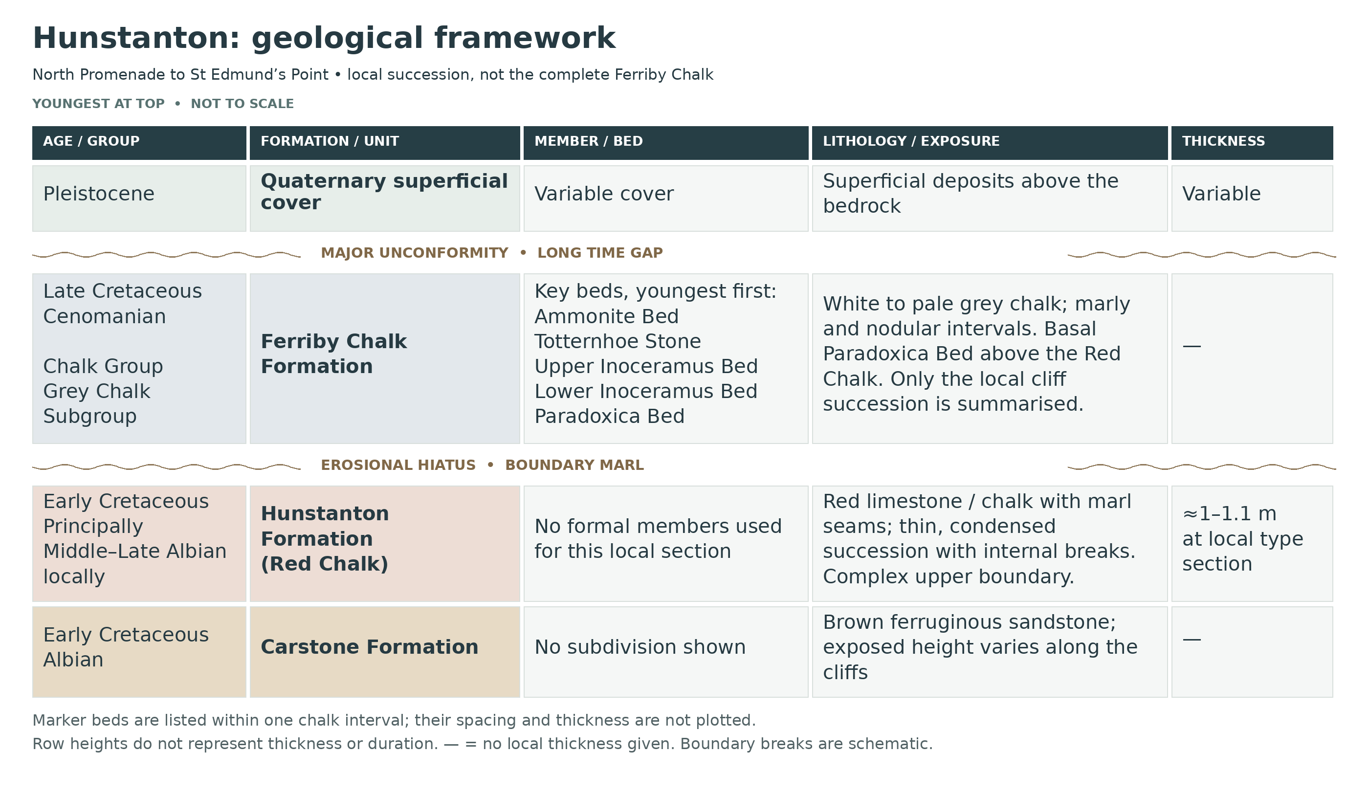
Hunstanton’s striped Cretaceous cliffs offer a clear introduction to Norfolk’s marine fossils. Brown Carstone, the thin Red Chalk and pale Ferriby Chalk form contrasting layers, with belemnites, brachiopods, bivalves and occasional ammonites preserved in their rocks. Weathered material on the beach gives collectors a chance to examine fossils without approaching the cliff face, while the harder beds reward patient observation rather than force. The sequence also records missing intervals of geological time, so its colours tell only part of the story. Plan your visit around low tide and keep well clear of unstable cliffs and recent falls.


FIND FREQUENCY: ♦♦♦♦♦ – A varied established fossil locality, although complete specimens require patience and suitable beach conditions.
CHILDREN: ♦♦♦♦♦ – Families can explore the open beach; close supervision and a wide clearance from cliffs are essential.
ACCESS: ♦♦♦♦ – Parking and established shore access are available nearby; the collecting beach is uneven and tidal.
TYPE: Cliff geology and loose foreshore material.
DIRECTIONS
♦ Approach Hunstanton on the A149 and follow signs towards the north end of the resort and Old Hunstanton. The council’s Cliff car park is on Lighthouse Close, PE36 6EL; use the signed public paths to an established beach access rather than attempting to descend the cliff. The geological section lies between North Promenade and St Edmund’s Point. Check access notices, tides and the car park’s current entrance hours before setting out.
♦ What3Words collecting area: ///excavated.dairies.hoped
FOSSIL HUNTING
Begin with loose, sea-washed material on the open beach. Identify the matrix before naming the fossil: rusty sandstone is Carstone, brick-red limestone is the Hunstanton Formation, and pale or grey chalk belongs to the overlying Ferriby Chalk. This simple distinction prevents fossils from different ages being mixed in one unlabelled collection. Search weathered surfaces and small loose fragments rather than unstable piles beneath the cliff.
The Red Chalk commonly yields the bullet-shaped guards of Neohibolites minimus, brachiopods recorded as Moutonithyris dutempleana, and inoceramid bivalves. These robust remains are more realistic targets than the rarer ammonites. Exact-locality records include Hoplites canavarii and Hoplites canavariiformis; strongly ribbed Actinoceramus sulcatus occurs in the condensed succession. Many attractive museum specimens represent decades of collecting, not the likely result of a single visit.
Pale chalk adds different fossils. The shelly Lower Inoceramus Bed contains Inoceramus crippsi, the oyster Rastellum colubrinum and small echinoids such as Holaster bischoffi. Higher fossiliferous chalk includes brachiopods, scallop-like bivalves and serpulid tubes. Branching Thalassinoides burrows in the very hard Paradoxica Bed are trace fossils left by animals living in the seabed; their network should not be mistaken for a branching sponge.
Ammonites reworked into the basal Carstone can occur in phosphatic material, but these are uncommon and the productive basal horizon is not a dependable everyday exposure. Finding an older fossil inside younger sediment does not mean that the two are the same age. Photograph unusual specimens with their matrix, record the precise find position and keep associated fragments together. Do not climb fallen blocks or enter the cliff’s fall zone to reach a named bed.


A chronological record of geological research and significant scientific milestones at Hunstanton Cliffs.
1815–1819 – The red and white rocks enter early geological mapping
William Smith included the two distinctive chalk units in his stratigraphical work and mapped them in Norfolk, establishing Hunstanton as a recognisable reference section.
1823–1836 – Early descriptions of the cliffs
Accounts by Richard Taylor, Samuel Woodward and William Henry Fitton helped document the exposed succession and its fossils during the early development of British stratigraphy.
1859–1864 – The Red Chalk is divided into beds
Thomas Wiltshire and Harry Seeley distinguished three limestone beds separated by two marly seams. That practical subdivision remains recognisable in the local section.
1980 – Early seabed cementation investigated
Christopher Jeans examined the hardgrounds, burrows and complex junction between the red and pale chalks, showing why the contact requires more than a simple colour-based description.
1994 – A detailed modern survey account
The geological survey memoir assembled the Hunstanton section, measured beds and fossil records into a detailed account of the local Cretaceous succession.
1995 – Carstone and Red Chalk ages revised
Hugh Owen’s study of the upper Carstone and Red Chalk refined their Albian stratigraphy and the interpretation of breaks within the condensed succession.
2012 – Fossils used to investigate seawater temperatures
Gregory Price and Elizabeth Harwood analysed belemnites and brachiopods collected from fallen Red Chalk blocks, assessing shell preservation before using their chemistry to study the Albian marine environment.
2014–2015 – Microbial crusts and iron staining reassessed
Research by Julian Andrews, Alan Kendall and A. Hall, published online in 2014 and in a 2015 journal volume, distinguished a possible Frutexites microbial crust from iron-stained nodules. The projecting nodules were not accepted as evidence of an intertidal stromatolite setting.
GEOLOGY
The main cliff succession passes upwards from the Carstone Formation through the Hunstanton Formation into the Ferriby Chalk Formation. Carstone is an iron-rich marine sandstone; its brown weathered colour contrasts with the red limestone above. The Red Chalk is only about a metre thick at its type locality, yet spans a substantial part of the Albian and contains several breaks in deposition. Its red pigment is finely distributed iron oxide.
The pale Cenomanian rocks above belong to the Ferriby Chalk Formation, within the Grey Chalk Subgroup of the Chalk Group. “Lower Chalk” is the familiar historical name, but it should not be confused with the younger, flinty White Chalk exposed elsewhere on the Norfolk coast. Ferriby Chalk here includes marly chalk, hard seabed surfaces and concentrated shell beds; the conspicuous Totternhoe Stone lies higher in the section.
The red-to-white junction is not simply a gradual colour change. Erosion and interrupted sedimentation removed part of the record, while burrowing and early cementation complicated the boundary. The beds dip gently eastwards, bringing their lower contacts closer to shore level towards St Edmund’s Point. Much younger superficial deposits cap parts of the cliffs and must be kept separate from the Cretaceous marine succession.

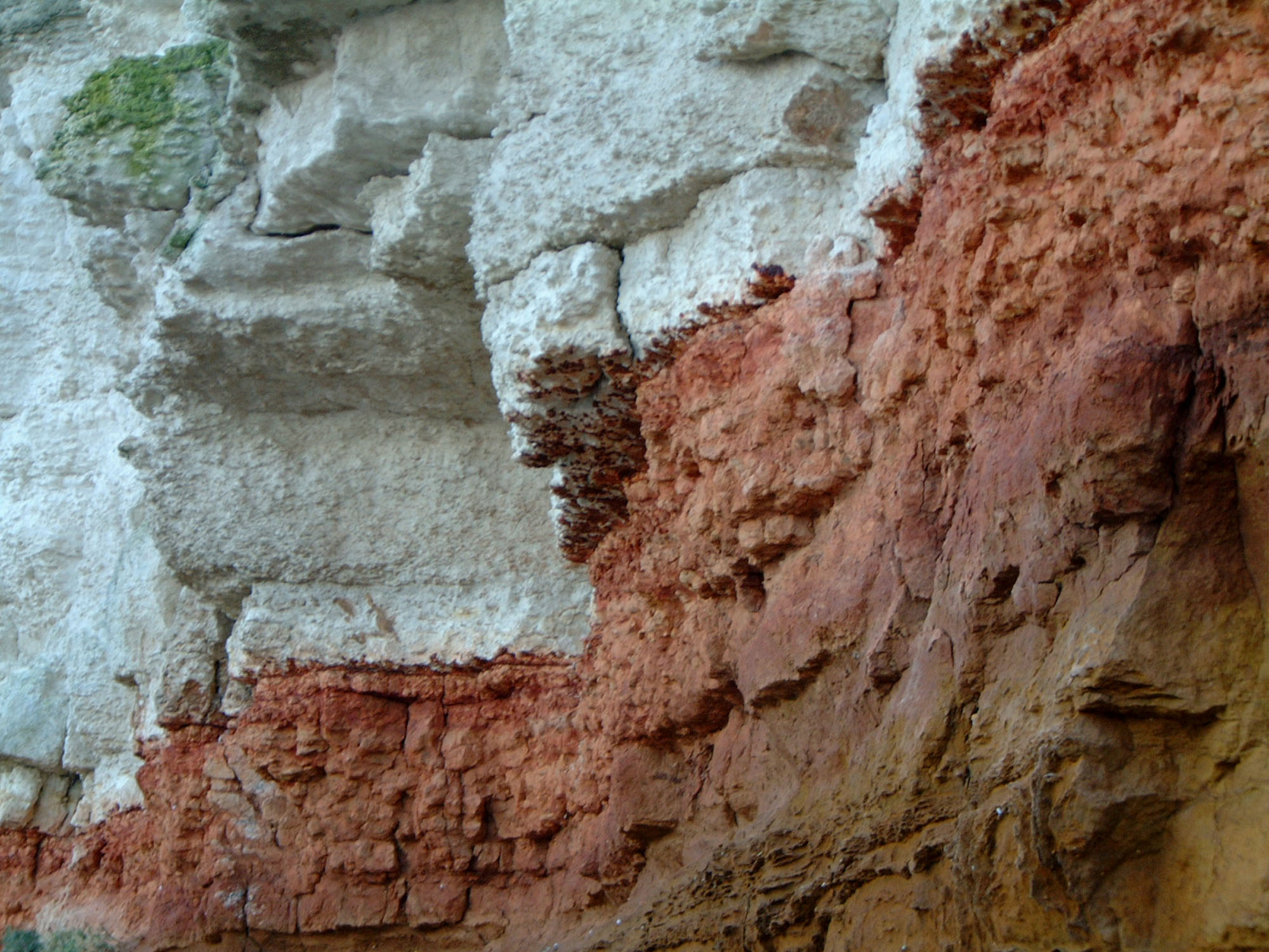
Detailed geology and stratigraphy of the Hunstanton cliff section.
The units below are described from youngest to oldest. They represent the cliff and shore between North Promenade and St Edmund’s Point, not a complete regional Chalk column. Bed boundaries include non-sequences, and exposures change as the beach and cliff retreat.
Quaternary superficial cover
Glacial and other superficial material locally overlies the Cretaceous rocks across a very large time gap. It is not a member of the Chalk. This cap is omitted from any scaled bedrock measurement because its thickness and exposure vary along the cliff.
CHALK GROUP
GREY CHALK SUBGROUP
Ferriby Chalk Formation
The Cenomanian succession is predominantly flint-free marly chalk with harder, shelly intervals. The cliffs expose only part of the formation; thicknesses quoted for the full formation elsewhere should not be applied to this exposure. From higher to lower in the accessible published succession, important markers are the Ammonite Bed, Totternhoe Stone, intervening marly and nodular chalk, Upper and Lower Inoceramus beds, and basal Paradoxica Bed.
Local measured sections and thicknesses. The following descriptions use the lighthouse composite section in Gallois (1994), supplemented by the later Geological Conservation Review account. These are published measurements of particular beds, not measurements of the present cliff or a complete Ferriby Chalk thickness. The memoir’s overview and its detailed lighthouse log give different thicknesses for some named beds; those differences are retained rather than silently selecting a universal value.
Chalk above the Ammonite Bed
The lighthouse log records, from top down, about 1.50 m of weathered, frost-disturbed chalk; 1.02 m of thin-bedded chalk with a concentration of marl wisps; 0.18 m of clay-rich chalk with closely spaced marl laminae; 0.41 m of softer thin-bedded chalk; a 0.10 m chalk–marl alternation; and 0.46 m of harder chalk with sparse marl streaks. These distinguishable lithological intervals are left unnamed: no regional marl name is imposed without a demonstrated correlation. The uppermost part is modified by weathering and cryoturbation. Higher markers such as the Nettleton Stone and Plenus Marls occur in the wider district and borehole record, but are not added as visible beds in this cliff guide.
Ammonite Bed and Upper Orbirhynchia Band
Immediately above the Totternhoe Stone lies a hard white chalkstone, represented by a 0.30 m very hard grey-white interval in the lighthouse log. Large, relatively uncrushed ammonites include Parapuzosia (Austiniceras) austeni. Its Orbirhynchia mantelliana fauna links it with the Upper Orbirhynchia Band, rather than with the lower brachiopod-rich level beneath the Totternhoe Stone. The GCR interpretation places this interval towards the top of the Turrilites costatus Subzone. Fossil-bed correlation does not imply that every ammonite-bearing loose block can be assigned to it.
Totternhoe Stone
A grey, gritty and strongly burrowed chalk rests on an erosional surface. Its lower part contains glauconitised and phosphatised chalk pebbles, some bored, and a concentration of shell debris. The detailed lighthouse log measures 0.48 m, whereas the memoir’s general account gives about 0.7 m at Hunstanton. Burrows filled with the darker gritty sediment descend into the underlying paler chalk, reaching 0.6 m in the measured lighthouse section. Fossils documented by the GCR include abundant Entolium orbiculare and Oxytoma seminudum, the serpulid Glandifera rustica, brachiopods including Grasirhynchia martini and Modestella geinitizi, and the belemnites Praeactinocamax primus and Belemnocamax boweri. Ammonites are commonly flattened or imperfect moulds. The bed is Middle Cenomanian; the basal erosion surface omits part of the Lower–Middle Cenomanian transition, including evidence of the basal Middle Cenomanian Cunningtoniceras inerme Zone.
Lower Orbirhynchia Band and underlying marly chalk
Below the Totternhoe Stone, brachiopod-rich marly chalk contains Orbirhynchia mantelliana, distinguishing the Lower Orbirhynchia Band. Beneath it are nodular and marly chalks with Inoceramus of the virgatus group. These faunal levels constrain correlation within the Mantelliceras dixoni Zone. The lighthouse log subdivides the interval below the Totternhoe Stone, downward, into 0.59 m of soft chalk penetrated by burrows from above, 0.13 m of chalk and marl, 0.61 m of chalk with few marl wisps, a 0.05 m marl-wispy interval, 1.07 m of chalk with scattered marl, and a further 0.15–0.23 m marl-wispy interval above the Upper Inoceramus Bed. These are measured lithological subdivisions, not six newly named formal beds.
Upper Inoceramus Bed and Turrilitoid Plane
This is the upper of two shell-debris-rich chalk intervals. The lighthouse log gives 1.12–1.14 m; the memoir’s general description gives 1.07 m. A conspicuous internal bedding plane occurs roughly half a metre above its base. The lower part contains a glauconitised surface, called the Turrilitoid Plane, associated with large poorly preserved heteromorph ammonites assigned to Hypoturrilites and/or Mariella. Thin-shelled inoceramids are prominent. The GCR places the renewed coarse shelly sedimentation near the base of the Mantelliceras dixoni Zone, revising the older memoir’s tentative correlation with the saxbii Subzone. The discrepancy concerns interpretation, not a second bed.
Chalk separating the two Inoceramus beds
The named shell-rich intervals are separated by 0.37–0.46 m of hard off-white chalk in the lighthouse log. Marl wisps form weak partings. Keeping this intervening chalk separate matters: the Upper and Lower Inoceramus beds are not a single uninterrupted shell bank.
Lower Inoceramus Bed
Grey gritty chalk with abundant complete and broken inoceramid shells overlies a hard irregular surface. A basal concentration of glauconitised and phosphatised chalk pebbles records erosion and reworking. The detailed lighthouse composite gives 0.92–0.95 m, while the memoir’s general text quotes 0.46 m; these cannot be treated as an unqualified single locality thickness. The GCR documents Inoceramus crippsi, Rastellum colubrinum, small Holaster bischoffi, rare Neohibolites ultimus and ammonites including Schloenbachia. Its later biostratigraphical interpretation assigns the bed to the Sharpeiceras schlueteri Subzone of the Mantelliceras mantelli Zone.
Paradoxica Bed: upper and lower divisions
The lowest Ferriby Chalk is exceptionally hard, burrowed chalkstone, 0.43 m thick in the lighthouse log. Its branching Thalassinoides paradoxicus network was historically mistaken for a sponge. Several closely spaced hardgrounds and green-stained surfaces record interrupted deposition and early seabed cementation. A prominent internal erosion surface separates lower and upper divisions. The upper division is retained in much of the southern and central section but dwindles to patches or disappears near St Edmund’s Point. The lower division contains Aucellina bivalves and Neohibolites ultimus; larger terebratulid brachiopods and inoceramids occur above. The GCR correlates the lower fauna with the ultimus/Aucellina event and the Neostlingoceras carcitanense Subzone, while noting that the index ammonite itself has not been recorded here.
Red boundary marl and the Albian–Cenomanian hiatus
A thin, laterally variable, dark-red marl occupies hollows above the eroded Red Chalk and below the Paradoxica Bed. Historical authors assigned it differently: it has been included at the top of the Red Chalk or treated separately at the base of the younger succession. Fossils include small terebratulids and Neohibolites ultimus. Comparison with more complete sections shows missing time beneath the Cenomanian chalk. The red colour therefore does not establish an Albian age by itself. Andrews and colleagues distinguish a possible Frutexites crust from projecting iron-stained nodules, rejecting those nodules as proof of an intertidal stromatolite environment.
Totternhoe Stone and adjacent chalk. The gritty Totternhoe Stone rests on an eroded and burrowed surface. Its fossils include Entolium orbiculare, Oxytoma seminudum and serpulid tubes. The overlying Ammonite Bed contains large ammonites assigned to Parapuzosia (Austiniceras) austeni. These are stratigraphical records, not a promise of readily accessible specimens.
Inoceramus beds and Paradoxica Bed. Shell-rich chalk records concentrated inoceramid debris and complete valves. At the base, welded hardgrounds and branching burrows give the Paradoxica Bed its distinctive appearance. The sedimentary record is interrupted both within this lower chalk and at its junction with the red beds.
Separate underlying formation: not part of the Chalk Group.
Hunstanton Formation: the Red Chalk
This is a separate formation rather than the lower member of the Ferriby Chalk in the current BGS Lexicon. At Hunstanton it comprises approximately 1–1.1 m of red to pink, partly sandy limestone and marly seams. Three main limestones with two separating marls form the traditional local subdivision. The five named members defined at Speeton belong to that Yorkshire succession and are not imported into this guide.
The main limestone sequence is Middle to Late Albian. Fossils and erosion surfaces show that it is strongly condensed, with intervals missing inside it as well as at its upper boundary. A thin, locally variable red marl at the top has been treated differently in historical accounts; the boundary should not be placed from colour alone. Research on the iron-stained structures distinguishes a possible microbial crust from non-microbial nodules, so an intertidal origin is not assumed.
Local subdivision. The five numbered units below are the lighthouse-section beds of Gallois (1994), listed from top down. Beds 5, 3 and 1 are the three principal limestones traditionally lettered A, B and C; beds 4 and 2 are their intervening marly seams. Those letters and numbers belong to this local scheme and must not be confused with the later HC numbering used for other Red Chalk sections.
Bed 5: upper limestone, divisions 5b and 5a
This 0.38–0.43 m bed is hard pink-to-red, fine-grained limestone, strongly mottled by burrows and nodular when weathered. An irregular purple-red surface in its upper part separates 5b from 5a. Sand and small angular pebbles increase downwards. Fossils recorded from 5b include Aucellina and Neohibolites praeultimus; 5a contains brachiopods, belemnites and inoceramids, including Inoceramus lissa in its upper part. Modern regional synthesis recognises successive Late Albian intervals and breaks within this condensed limestone; it should not be drawn as an uninterrupted record of every intervening ammonite zone.
Bed 4: upper red marly seam
A dark-red to reddish-brown, earthy, highly calcareous muddy seam is locally up to 30 mm thick. Sand grains, tiny quartz and ironstone pebbles and worn belemnites are conspicuous. Its irregular basal contact has been affected by local shearing, so the seam may be reduced or missing. The published fauna includes Moutonithyris dutempleana, Kingena spinulosa and several Neohibolites forms.
Bed 3: middle nodular limestone
The middle limestone is 0.41–0.43 m thick in the lighthouse section. Sandy, burrow-mottled pink and red chalky limestone contains clay-rich linings and pressure-solution seams and weathers into a rubbly nodular layer. Belemnites and brachiopods occur through it. The modern Albian interpretation recognises a major interruption within the middle limestone: an older basal component and younger Late Albian material cannot be treated as a single smoothly accumulated interval. The strongly ribbed inoceramid Actinoceramus sulcatus is associated with the condensed nodular succession in the regional synthesis.
Bed 2: lower red marly seam
The lower separating seam is dark-red, sandy calcareous clay, locally up to 20 mm thick. In places shearing has removed the clay, leaving an irregular iron-stained surface. It is a real local lithological marker, but its absence in one exposure does not demonstrate that the limestones on either side are the same bed.
Bed 1: basal sandy limestone
The basal 0.23–0.28 m is softer and much sandier than the higher Red Chalk. Downwards it changes, through strong burrowing, into pink and brown calcareous sand. Its lower contact is a sharp, approximately planar but burrowed surface on the Carstone. Recorded fossils include Moutonithyris dutempleana, inoceramid bivalves and Neohibolites minimus. Ammonites in the traditional lower limestone include Hoplites and support a Middle Albian age.
Separate underlying formation: not part of the Chalk Group.
Carstone Formation
The underlying marine sandstone contains iron-rich grains, quartz and pebbles. Its upper beds pass towards the more calcareous red succession, with burrowing across the transition. Older ammonites incorporated into basal phosphatic material are reworked fossils. The nearby Hunstanton Borehole proves 18.9 m of Carstone, but that is a borehole thickness, not the visible height of sandstone in the cliffs.
Detailed coastal subdivision. The BGS Albian compilation numbers five Carstone units C-HC1 to C-HC5 for Hunstanton Cliff and foreshore. The following top-down account retains those published identifiers. It is a composite coastal succession, not a claim that the whole thickness is visible above the beach at any one place or tide.
C-HC5: upper bioturbated sand, 0.13–0.42 m
Fine orange-brown ferruginous sand is soft and earthy, with sparse phosphatic nodules below and burrow fillings of red or pink mud brought down from the overlying beds. Its base is transitional. This interval combines Owen’s uppermost subdivisions 2ii–2iv of his Upper Carstone Member: a lower red sand with a nodule seam, an overlying olive-brown loamy sand and a thin clayey yellow-red sand at the top.
C-HC4: pebbly upper sandstone, about 0.80 m
Fine- to medium-grained orange-brown sandstone contains small phosphate nodules and pebbles. Burrowing is shown by partly phosphatised sandy fillings. It corresponds to Owen’s Upper Carstone bed 2i; the combination with C-HC5 should not erase the lithological contrast between the firmer lower sandstone and softer upper sands.
C-HC3: ferruginous sand above an erosion surface, 2.00–2.50 m
Brown to yellow pebbly sand contains mud drapes and occasional phosphate nodules towards its top. It passes down into a basal pebble concentration on an uneven eroded surface. Owen treated this as bed 1 of the Upper Carstone Member.
C-HC2: massive lower sandstone and basal phosphate bed, about 13.90 m
This thicker interval is dark-brown, massive, pebbly and locally gritty, with iron-rich ooids. At its base is a phosphate-pebble bed containing reworked Aptian ammonites, including Cheloniceras, Dufrenoyia, Prodeshayesites and Tropaeum. These older fossils date their source rocks rather than the enclosing Albian sandstone.
C-HC1: basal sandy clay, about 1.30 m
The lowest coastal Carstone unit is pebbly, ooidal clay with sandy parts and sparse large rounded nodules of fossiliferous phosphatic ironstone near its top. Its base is sharply irregular and burrowed against the older Roach. The Roach contact belongs to the lowest part of the composite coastal record and should not be represented as a normally conspicuous bed in the three-coloured cliff face.
References
BGS, The holostratigraphy of the Albian Stage, section 6.2.5: Hunstanton Cliff Carstone log
BGS, East Anglia regional geology: revised Red Chalk biostratigraphy
BGS Lexicon: Hunstanton Formation
BGS Lexicon: Ferriby Chalk Formation
BGS Lexicon: Carstone Formation
Mortimore, Wood and Gallois, British Upper Cretaceous Stratigraphy: Hunstanton Cliffs
SAFETY
Rock falls occur along the cliff frontage, including away from visibly fresh scars. Keep well out from the base and never sit, shelter or search beneath overhangs. A hard hat does not make the fall zone safe. Do not climb cliff-fall material, use ladders against the cliff or approach the edge from above.
Visit on a falling tide with time to return by your chosen access. The sea can narrow the beach against the cliffs, and wet rock and seaweed are slippery. Avoid rough weather and swell, keep children on the open beach, and turn back before the route becomes restricted.
EQUIPMENT
Bring sturdy footwear, tide information, a hand lens, a camera and small rigid boxes with wrapping material. A notebook or phone record should distinguish the find position and red, white or sandstone matrix. A heavy hammer is not essential for a useful visit. Do not use tools on the cliff or attached beds; seek site-specific permission before any sampling beyond loose material.
CLEANING AND TREATING
Start with a soft dry brush and inspect the specimen under magnification. The Red Chalk is hard and can fracture through a shell rather than separate from it; retain protective matrix rather than levering it away. Pale chalk can be softer, but thin shells, spines and tubes are easily lost. Use brief gentle rinsing only on sound, stable specimens, then dry slowly at room temperature.
Do not use acids to remove carbonate matrix: they can also destroy calcitic shells and belemnites. Avoid bleach, wire brushes, oil and varnish. If a specimen is genuinely friable, obtain advice before applying a reversible consolidant such as Paraloid B-72. Leave unusual fossils unprepared until they have been assessed, keeping all fragments and locality notes.
Identify your finds
Need help identifying a fossil? Share clear photos, where you found it and its size with the community.
FURTHER READING
Deposits: Locations in the Norfolk area, including Hunstanton
Geological Conservation Review: Hunstanton Cliffs
BGS: Geology of King’s Lynn and The Wash
BGS Lexicon: Hunstanton Formation
BGS Lexicon: Ferriby Chalk Formation
Belemnites, brachiopods and Hunstanton’s Albian sea temperatures
Research on microbial crusts and iron staining at the red–white chalk boundary
ACCESS RIGHTS
Hunstanton Cliffs is a Site of Special Scientific Interest, protected for its geology and associated natural interest. Public beach access does not confer unrestricted permission to excavate or damage the exposure. The beaches at Hunstanton are privately owned, so even collecting loose fossils may require the landowner’s permission. Check current local rules and obtain permission where required before collecting. Observe signs and landowner guidance, leave the cliff and attached beds intact, and ask the landowner or site manager before any organised sampling. The protected-site designation alone should not be read as a universal rule applying identically at every SSSI.
It is important to follow our ‘Code of Conduct’ when collecting fossils or visiting any site. Please also read our ‘Terms and Conditions‘
LINKS
♦ Fossil Discussions
♦ Fossil Articles
♦ Buy Fossils, Tools and Equipment
♦ Buy Crystals, Meteorites, and Artefacts
♦ Join Fossil Hunts
♦ UK Fossils Network