
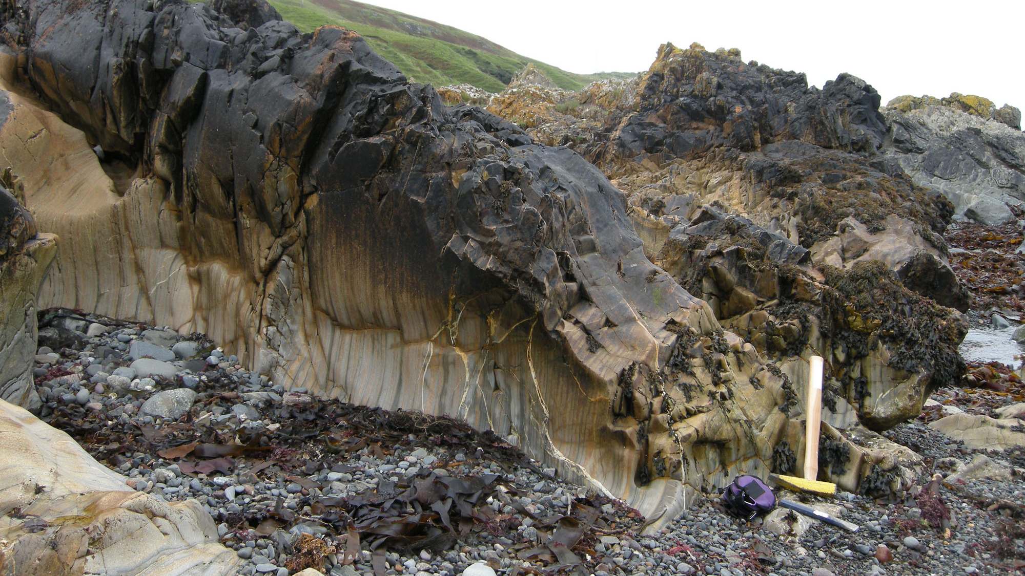
Overview
Directions
- From Girvan, follow the A77 south past Ardwell towards Kennedy’s Pass, the coastal bend marked on Ordnance Survey maps.
- The original guide places the Pass just under 2 km beyond Ardwell. Historic accounts describe nearby lay-bys, but disagree about which side of the road to use; current parking availability and restrictions need checking before travel.
- Do not treat the old cliff descent as a verified access route. Establish a safe, lawful approach without climbing the cliff or stopping in an unsafe roadside position; turn back if none is available.
- Locality reference: 55.19768°N, 4.91166°W. This identifies the locality, not a parking space or safe descent.
Location photographs
Swipe to browse · Select a photograph to enlarge


Fossil Hunting
The main fossil interest lies in the finer Bellmoor Member beneath the Kilranny Conglomerate Member. The formal Kennedy’s Pass field account records occasional brachiopods and trilobites in these former “infra-Kilranny” beds, including the exposure in the cutting inland of the road. That record establishes their presence in the local section, rather than a fossil-bearing layer that can always be reached on the beach. Road cuttings are geological reference exposures, not an invitation to search beside moving traffic.
A published Bellmoor Member assemblage from the Kennedy’s Pass area includes the brachiopod genera Dolerorthis, Eoplectodonta, Leptellina, Lingulella, Sulevorthis and Rostricellula. The published assemblage is not tied to a single intertidal bed: these names should not be used as a checklist of finds expected in freshly scoured shore rock or in the coarse Kilranny conglomerate. No species names or named local trilobites are established here.
Where finer rock is already exposed and can be examined safely, look closely at naturally weathered surfaces rather than judging the whole shore by its conspicuous pebbles. Brachiopod shell impressions and trilobite fragments may be subtle against the grey matrix. A hand lens and oblique light help distinguish repeated shell ribs or segmented surfaces from cracks and mineral markings. Photograph a possible fossil with a scale and its surrounding rock before attempting an identification; rounded pebbles and unusual rock shapes alone are not evidence of fossils.
The original observations describe finer foreshore material becoming visible when mobile beach cover is removed. Such exposure is temporary, and storm scouring is not a reason to visit in rough weather. The coarse conglomerate is more rewarding for studying clasts, bedding and sediment transport than for a reliable fossil search. Until the necessary collecting arrangements are clear, observe and photograph; the access section explains the ownership and conservation requirements.
Discoveries and milestones
Significant discoveries and scientific milestones at Kennedy’s Pass.
1851 – Early scientific description
Roderick Murchison’s published account discussed the conspicuous conglomerate at Kennedy’s Pass within an early interpretation of the regional succession. The nineteenth-century term “Silurian” included rocks now assigned to the Ordovician; this was geological description, not a documented new fossil discovery.
1882 – Lapworth maps the faulted Pass
Charles Lapworth published a detailed plan of Kennedy’s Pass and described the numerous faults in its road cutting and cliffs. His assignment of the main conglomerate to Benan was subsequently revised.
1899 – Geological Survey records the shore structures
Ben Peach and John Horne documented the faulted shore contact, its basalt dyke and the varied conglomerate clasts. Their interpretation of the conglomerate and exclusively local clast sources has been superseded by later work.
1932–1935 – Henderson investigates the upper contact
S. M. K. Henderson drew attention to the conglomerate–Ardwell junction during the 1932 Geologists’ Association visit and studied it in his 1935 thesis and paper. The contact became known as Henderson’s unconformity, although its original interpretation was later reconsidered.
1962 – Williams separates the conglomerates
Alwyn Williams distinguished the Kilranny Conglomerate and underlying infra-Kilranny greywackes in the lower Ardmillan succession and documented brachiopod assemblages from the Kennedy’s Pass area. This work helped establish that the headland conglomerate is distinct from the older Benan unit.
1978 – A submarine channel replaces the unconformity interpretation
John Keith Ingham interpreted the irregular top of the Kilranny Conglomerate as an erosional channel filled by finer Ardwell sediment. The local contact consequently ceased to be straightforward evidence of a major uplift and emergence event.
1988 – BGS details the lower coastal succession
Peter Stone and John Smellie illustrated the lower Balclatchie section south of Kennedy’s Pass, showing fine beds above Benan Conglomerate, a channelled sandstone packet and the transition into Kilranny conglomerate.
2014 – The brachiopod assemblage is reappraised
Yves Candela and David Harper retained a distinct Bellmoor Member assemblage from the Kennedy’s Pass area in their revised brachiopod synthesis, separating it from the Shiel Hill fauna and placing it within an upper Sandbian framework.
Geology
The fossil-bearing rocks belong to the Balclatchie Formation of the Ardwell Subgroup, within the Ardmillan Group. They are Late Ordovician, upper Sandbian in age. The formation records changing marine sediment supply near the active margin of Laurentia: laminated fine sediment and sand alternated before much coarser sediment entered submarine channels. The often-quoted thickness of about 300 m applies to the formation in the Girvan district, not to the height of the roadside cliff.
The lower Bellmoor Member, formerly the infra-Kilranny Greywackes, contains repeated siltstone and sandstone beds. Its southern coastal section includes an uneven contact above the older Benan Conglomerate, a coarsening and thickening sandstone packet, and upper sandy pebble-conglomerate layers. The Benan belongs to the Barr Group; it is not an alternative modern name for the Kilranny Conglomerate at the headland. These intervening finer beds are important both for reconstructing the succession and for understanding its fossil records.
The Kilranny Conglomerate Member contains grey-green to blue-grey coarse sandstone, pebbles, cobbles and scattered boulders. Some parts are held together mainly by sandy matrix, others by a close framework of clasts. Pink granite and other igneous clasts reveal erosion of older rocks, while scour surfaces, imbrication and occasional cross-bedding record powerful sediment movement. The deposit represents submarine coarse sediment delivery by mass flows and moving currents, rather than an ancient beach shingle bank.
On the north side of the headland, younger fine sediment of the Ardwell Farm Formation fills an irregular hollow cut into the top of the Kilranny Member. This is the contact historically called Henderson’s unconformity, now interpreted as submarine channelling. Faults complicate the present exposures, so the locality is not a single uninterrupted stack. The younger folded Ardwell foreshore continues north-east beyond this short guide’s central exposure; the whole Girvan coastal succession should not be read into the small cliff.

Detailed geology and bed-by-bed succession
Detailed geology and stratigraphy of the Kennedy’s Pass section.
The account below runs from older to younger rocks and combines the southern coastal section, the headland and its northern contact. Stone and Smellie’s diagrammatic Figure 29 supplies the approximate Bellmoor heights, measured above the Benan top in that source. They are not cliff elevations, a continuous roadside log or a guarantee of current exposure. Descriptive packet labels are used because no formal named or numbered fossil beds have been established.
Underlying substrate: Benan Conglomerate Formation, Barr Group. In the southern coastal log, the first fine Balclatchie laminae mantle an irregular Benan surface and lap onto exposed cobbles and boulders. This contact separates the older conglomerate from the overlying finer succession. No local Benan thickness is assigned here; at the central headland stop, faulting removes parts of the underlying succession from view.
ARDMILLAN GROUP
ARDWELL SUBGROUP
The local formations lie within the Ardwell Subgroup. They record marine sedimentation at the Laurentian margin, with repeated turbidity currents, channel erosion and coarse mass-flow deposition. Later deformation and faulting disrupt the original relationships.
Balclatchie Formation
Upper Sandbian, Late Ordovician. The BGS formation-wide thickness of about 300 m is a Girvan-district figure. The local coastal development comprises Bellmoor Member below Kilranny Conglomerate Member; the different member succession farther south-east in the Penwhapple–Stinchar belt is not inserted here.
Bellmoor Member
Formerly the infra-Kilranny Greywackes. BGS gives a member thickness range of 90–140 m; the diagrammatic southern coastal section shows approximately 90 m between Benan below and the main Kilranny conglomerate above. Occasional brachiopods and trilobites are documented in the finer Kennedy’s Pass beds, but neither the field account nor the published area assemblage assigns taxa to the following individual packets.
Basal contact and lower alternations, approximately 0–40 m. Fine laminae drape the uneven Benan surface. Laminated siltstone alternates with repeated sandstone beds, and a subordinate small conglomeratic lens is shown low in the interval. The member is therefore not a uniform mudstone sheet; the lower alternations retain evidence of repeated sand delivery.
Channelled sandstone packet, approximately 40–55 m. A channelled base near the 40 m level contains ripped-up siltstone clasts. The sandstone above becomes coarser and its beds thicken upwards. Its roughly 15 m span is read from the diagram, not a separately measured exact thickness or a formal bed designation.
Upper alternations and coarse transition, approximately 55–90 m. Laminated siltstone and repeated sandstone interbeds resume. Sandy pebble-conglomerate layers with erosional bases enter towards the top, and repeated channelling accompanies the transition into the main coarse unit. The source’s individual thin sandstone marks cannot be converted into named beds or precise layer thicknesses.
Kilranny Conglomerate Member
Basal scour and variable transition. In the east-side road quarry, the basal conglomerate cuts approximately 4 m into fine laminated beds. This is local erosional relief, not the thickness of the member. In the southern coastal section, sandy conglomeratic interbeds thicken and merge into the main coarse succession. These laterally variable relationships should not be conflated with the younger erosional contact at the member’s top.
Main coarse succession. Coarse grey-green to blue-grey sandstone contains pebbles and scattered larger cobbles and boulders, passing into conglomerate with both matrix-supported and clast-supported fabrics. Bedding is often crude, becoming clearer locally higher in the unit. Imbricated clasts, rare cross-bedding and local reverse grading near the base are recorded. Volcanic and intrusive clasts include conspicuous pink granite; regional interpretations favour a northern source and an eroded igneous arc, rather than assigning every clast to the adjacent Ballantrae outcrops. Stone and Smellie describe about 120 m in the coarse coastward succession; the BGS member maximum is 150 m, with neighbouring hill exposures contributing to wider estimates. These are not present cliff heights.
Upper erosional contact: Henderson’s unconformity. Near NX 1490 9330, on the northern side of the headland, the conglomerate top is irregular and scoured. Fine Ardwell sediment fills the channel and recesses locally overhung by conglomerate. The historical name does not demonstrate major subaerial emergence or a region-wide angular unconformity: modern accounts describe submarine erosion. Such local channelling is compatible with an overall conformable formation relationship.
Ardwell Farm Formation
Local basal channel fill. Dark green-grey siltstone and silty mudstone carry millimetre-scale pale fine-sandstone laminae, with less frequent medium sandstone beds and local graded coarse-sandstone or pebble-conglomerate lenses. Flaggy beds fill irregularities in the Kilranny surface; small faults with injected sandstone are described at this basal exposure. These features are not separately named members. The formation extends from upper Sandbian into lower Katian; its regional thickness, about 1,000 m in the BGS Lexicon, must not be mistaken for what is visible at Kennedy’s Pass.
Adjacent Ardwell foreshore context. North-east of the headland, a longer succession shows thin sandstone–siltstone alternations, graded bedding, slumping and conspicuous cascade folds. Their origin has been debated, with soft-sediment slumping favoured in several later accounts. Uncommon graptolites and orthocone nautiloids are recorded from the younger Ardwell succession, including the quarry near Ardwell Farm; these are not records from the Bellmoor fossil beds. This extended shore and its historical subdivisions are outside the local log above.
Names and limits. Older references use Ardwell Flags or Ardwell Formation for the younger rocks. The older volcanic Kennedy’s Pass Formation belongs to the Balcreuchan Group and is a different, fault-adjacent unit, not part of this fossil-bearing stack. “Caradoc” in older sources is a regional age term, not an exact synonym for Sandbian. No precise numerical age has been demonstrated for an individual local fossil bed.
References
Stone, P. & Smellie, J. L. (1988), The Ballantrae area, Chapter 5 and Figure 29.
Ingham, J. K. (1992), Girvan Foreshore, Excursion 30, localities 1–2.
Rushton and colleagues (1999), British Cambrian to Ordovician Stratigraphy, Girvan Foreshore, pp. 336–341.
Candela, Y. & Harper, D. A. T. (2014), Synoptic revision of the Ordovician brachiopods of the Barr and Lower Ardmillan groups, pp. 63–64.
BGS Lexicon: Ardmillan Group; Ardwell Subgroup; Balclatchie Formation; Bellmoor Member; Kilranny Conglomerate Member; Ardwell Farm Formation.
Safety
Plan any shore visit around low tide and settled weather, checking local tides and current road or access notices immediately beforehand. The sea can reach the cliff base and cut off the shore; neither the old guide nor the historic geological excursions establish all-tide access. Keep a clear return route and leave well before the tide threatens it. Avoid rough seas, wet slabs, unstable blocks and the foot of loose cliffs.
The busy A77 and hazardous cliff approaches are as important as the tide. Do not collect in roadside cuttings, climb barriers or improvise a cliff descent. A low cliff is not necessarily a safe cliff. Stout footwear and a companion are advisable, and this locality is unsuitable for visitors needing an easy or step-free approach unless a current assessment establishes one.
Equipment
Take a hand lens, camera, scale, notebook and suitable footwear for close observation. Carry a charged phone and check the weather and tide forecast before setting out. If collection of particular loose material has been authorised, bring labels, padding and a small container so its precise source can be recorded. A heavy hammer and splitting chisel are not routine essentials here; do not work the outcrop or clear its cover without the necessary arrangements.
Cleaning And Treating
For material lawfully collected under the agreed conditions, record the locality and host rock before cleaning. Start with a soft dry brush and photograph fragile impressions before disturbing them. Thin silty or laminated pieces can split along bedding, so avoid prolonged soaking or forceful scrubbing. Do not use acids or indiscriminate chemical treatments. Leave difficult preparation until the specimen and matrix have been assessed, retaining both counterparts and a little surrounding rock where available.
Identify Your Finds
Need help identifying a fossil? Share clear photos, where you found it and its size with the community.
Further Reading
BGS: The Ballantrae area, including the Kennedy’s Pass coastal section
Geological Society of Glasgow: Girvan Foreshore excursion
BGS: Girvan and Ballantrae excursion
Candela and Harper: Girvan Ordovician brachiopods
NatureScot: Girvan to Ballantrae Coast Section SSSI
Access Rights
Kennedy’s Pass lies within the Girvan to Ballantrae Coast Section SSSI. Its management statement supports responsible, code-compliant collecting while protecting vulnerable fossil-bearing outcrops. No current landowner permission, applicable collecting consent or closure has been established for this guide. Treat it as an observation-first visit until the appropriate arrangements are clear.
Responsible access to land does not confer ownership of fossils. Before removing material, establish permission with the relevant mineral-rights holder, who may differ from the landowner, and any landowner or occupier permission required. Separately, activities affecting the protected features may require NatureScot consent arranged through the owner or occupier. The site’s listed operations include mineral extraction and modification of outcrops or clearance of loose rock; this is a consent framework, not evidence that every small loose find is prohibited. It is equally not an unrestricted collecting licence. If the applicable arrangements are uncertain, do not collect.

Follow the Scottish Fossil Code at this and every Scottish locality. Avoid damage to bedrock and fossil-bearing exposures, and report a potentially important find with its location and photographs rather than attempting an unplanned extraction.
It is important to follow our Code of Conduct when collecting fossils or visiting any site. Please also read our Terms and Conditions.
Links
♦ Fossil Discussions
♦ Fossil Articles
♦ Buy Fossils, Tools and Equipment
♦ Buy Crystals, Meteorites, and Artefacts
♦ Join Fossil Hunts
♦ UK Fossils Network


