
Overview
Directions
- Kilmarie lies on the B8083 between Torrin and Elgol. From the Torrin direction, turn left onto the minor road through Kilmarie towards the shore of Loch Slapin.
- The established walking-route start is the small parking area beside Kilmarie burial ground, near Kilmarie House (NG554172). Keep the lane, gates and access to the house clear, and follow any current signs or requests on site; the old instruction simply to park beside the house should not be treated as permission.
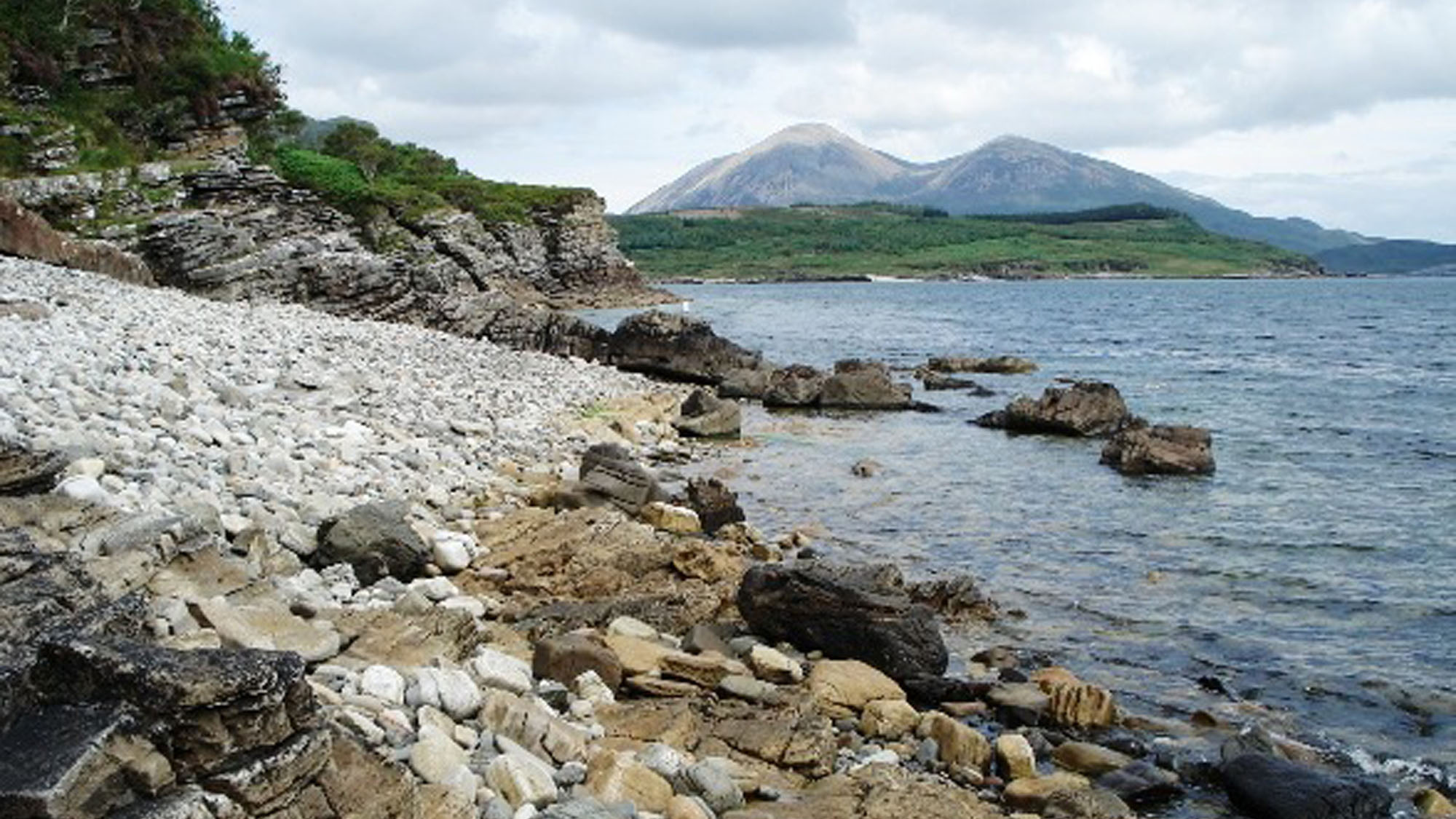
- Approach the shore and explore southwards along the beach, checking that the return remains open. The original collecting guide stops at the headland pierced by a large hole; beyond it the shore is harder to negotiate and more affected by the tide.
- Original guide reference: 57.18270°N, 6.05603°W. This is a locality reference, not a guarantee of a parking space or an accessible shore at every state of tide.
Location photographs
Swipe to browse · Select a photograph to enlarge


Fossil Hunting
The useful search area is the rocky shore south of the Kilmarie approach, along the western side of Loch Slapin. Work through the beach pebbles and cobbles as well as the already exposed surfaces of the low ledges. The established guide records finds throughout this stretch, rather than a single particularly productive patch. Its practical southern limit is the headland pierced by a large hole; there is no need to continue beyond it to look for the characteristic fossils.
Belemnites are the main target and are often seen in section through a stone, rather than as complete loose specimens. These were squid-like marine animals, and the hard part commonly preserved is their calcite guard, or rostrum. A lengthwise cut can look like a tapering finger or spindle; a cross-section is more rounded or oval. Under a hand lens, a well-preserved section may show fine calcite fibres radiating towards the outside and concentric growth lines. Shape and internal structure are more useful than a pale patch alone when deciding whether a mark is a belemnite.
Kilmarie also yields blocks with bivalves and brachiopods. Look for curved shell sections, ribs and repeated shell outlines within the matrix. Some specimens show only fragments, while the existing locality photographs include a block with more recognisable shells. Bivalves and brachiopods are different animal groups despite both having two valves; worn fragments may not retain the features needed to tell them apart. It is better to record an uncertain shell honestly than give a species name to an incomplete cross-section.
The locality photographs also record crinoid-rich debris. Crinoids are echinoderms whose skeletons break into many small pieces after death, so the useful clue here is an accumulation of pale skeletal fragments within a sedimentary rock. Do not expect an intact sea-lily crown from every crinoidal pebble. Shell-rich, calcareous rock can contain a mixture of recognisable fossils and much finer broken debris, making a hand lens worthwhile even when a stone initially looks unpromising.
Take time to distinguish sedimentary cobbles from the abundant igneous stones on the beach. Crystals and mineral-filled patches can resemble fossil sections. Compare several features together: a coherent shell or guard outline, repeated biological structure and the surrounding rock texture. The photographs below are useful examples of how Kilmarie material appears on weathered and broken surfaces. Inspect existing surfaces before considering any collection; a photograph with a scale can preserve details that are hard to see in an overall view.
For any permitted loose find, record where it was found and that it came from beach material. A wave-rounded cobble has lost its original bed position, even if a similar rock is exposed nearby. Keep in-situ fossils in place and photograph their relationship to the surrounding strata. The hard matrix can break through a fossil rather than release it cleanly, so indiscriminate splitting is unlikely to improve a specimen. Follow the Scottish Fossil Code and the current access and collecting guidance below.
Fossil photographs
Swipe to browse · Select a photograph to enlarge


Discoveries and milestones
Published geological milestones for Kilmarie’s fossil-bearing coastal rocks.
1910 – Geological Survey documents the calcareous coastal succession
The published district memoir described the alternation of calcareous flags, grits and more massive sandstone along eastern Strathaird, including the coast at Kilmarie. It also recorded belemnites and young oysters in calcareous concretions near the descent to the coast. These observations established a useful early account of the rocks and marine fossils encountered around the locality; the separate shell-rich bed in the inland river was recorded as a different exposure.
1981 – Kilmarie’s coastal calcareous facies is identified in a published excursion
The Edinburgh Geological Society’s Skye excursion itinerary explicitly included the coast of Loch Slapin at Kilmarie and identified its rocks as the calcareous facies of the Bearreraig Sandstone. Published later that year, this is a clear locality-specific record linking the visitor shore to the formation and its carbonate-rich character. It documents geological interpretation and teaching at the shore, rather than the discovery of a new fossil species.
Geology
The fossil-bearing coast southeast of Kilmarie is part of the calcareous development of the Bearreraig Sandstone Formation. Bedrock mapping assigns the shore south of the river mouth to the Druim An Fhurain Sandstone Member, also spelt Druim an Fhuarain in geological literature. This is a marine sandstone and sandy-limestone succession, distinct from the younger Elgol Sandstone Formation. The name “sandstone” does not mean that every bed is a pure quartz sand: calcium carbonate and broken skeletal material are important components of these rocks.
The Strathaird succession belongs principally to the Aalenian and Bajocian stages of the Middle Jurassic. Across its wider outcrop, the Bearreraig Sandstone Formation extends back into the latest Toarcian, in the Early Jurassic. Those regional limits do not date each Kilmarie ledge or loose cobble precisely. An ammonite zone has not been securely established here for every part of the visitor shore, so a single numerical age would suggest more precision than the evidence provides.
These sediments accumulated in a sea supplied with sand from nearby land. Currents redistributed the sand together with debris from marine organisms. Cross-bedding, where inclined layers lie within a bed, records the movement of sedimentary bedforms. Studies of the Strathaird sandstones interpret strong tidal influence; at Kilmarie, published observations include cross-bedding in both northerly and southerly directions. Broken shells and other skeletal grains form part of the sediment itself, whereas larger belemnite guards can remain conspicuous within it.
The coast shows the practical consequences of this mixture of sand and carbonate. Historical descriptions of eastern Strathaird distinguish thin-bedded, calcareous flags and grits from more massive sandstone beds, with large calcareous concretions in places. Fresh rock was described as blue-grey, becoming pale, white or yellow on weathering. These varied textures help explain why one loose stone may show only small shell fragments while another reveals larger belemnite sections. They are variations within the sandstone succession, rather than evidence that each fossiliferous cobble belongs to a separate formation.
The present shore is much younger than its Jurassic bedrock. Waves expose ledges, remove weathered material and round fragments into beach stones. Igneous rocks are mixed into the shingle, while the older Survey account describes dykes interrupting the sedimentary cliffs along eastern Strathaird. Erosion along these intrusions contributes to the broken character of that coastline. Loose beach material therefore needs to be distinguished from the intact strata: it is excellent for seeing fossil sections, but less useful for reconstructing a precise vertical sequence.
The detailed section below describes the rock types and evidence relevant to this shore. It does not transfer the separate inland Kilmarie river sections, or the successions at Elgol and Bearreraig Bay, onto the beach. In particular, the Dun Caan Shale Member is a separate subdivision of the Bearreraig Sandstone Formation, not a former name for the Druim An Fhurain Sandstone Member.

Detailed geology and bed-by-bed succession
Detailed geology of the Kilmarie shore, its calcareous sandstone facies and the limits of the documented succession.
This account covers the fossil-bearing shore southeast of Kilmarie, south of the river mouth on Loch Slapin. The evidence combines bedrock mapping with published coastal observations. It is a framework for the exposures and loose fossiliferous material, not a measured bed-by-bed log of the walking route.
Bearreraig Sandstone Formation
The formation has no parent group in the BGS stratigraphical framework. It is a predominantly marine sandstone succession with important calcareous components. Its full regional age range is latest Toarcian to Bajocian, but its development in Strathaird differs considerably from the type succession in north-east Skye. The older expression “Inferior Oolite” was used for these rocks before modern lithostratigraphical nomenclature was introduced; it should not be read as a statement that the Kilmarie shore is built of the English Inferior Oolite limestones.
Druim An Fhurain Sandstone Member
BGS 1:50,000-scale mapping identifies this member along the shore south of the Kilmarie river mouth. It forms the thick sandstone-and-limestone part of the Bearreraig Sandstone Formation in Strathaird. Cross-bedded sandstone, sandy limestone and massive sandstone vary laterally and vertically. The coastal calcareous facies at Kilmarie was also specifically identified in a published geological excursion account. No separate formal bed or named fossil horizon has been securely tied to the complete visitor stretch.
Calcareous flags, grits and sandy limestone
The early Survey description of eastern Strathaird records blue calcareous and gritty flags, alternating with thin, current-bedded calcareous sandstones. Carbonate-rich skeletal debris is a significant part of this rock type. The formation’s regional fauna includes crinoids, bivalves, brachiopods, bryozoans and belemnites, but the directly documented Kilmarie collecting material should be restricted to the groups shown or reported from the shore: belemnites, bivalves, brachiopods and crinoid debris. This distinction avoids turning the member-wide fossil list into a promise of particular beach finds.
More massive sandstone beds
The same coastal account describes more massive sandstone interspersed with the thinner-bedded rocks, weathering white or yellow; occasional small-pebble seams were also recorded along eastern Strathaird. These are lithological observations for the coastal succession, not numbered beds with established boundaries at Kilmarie. Differences in bedding and weathering are useful features to record beside a fossil, but colour alone cannot establish either its exact horizon or its geological age.
Calcareous concretions and fossil concentrations
Large calcareous concretions, historically called doggers, were recorded in the east-coast sandstones. The Survey also reported belemnites and young oysters in concretions near the middle of the sandy succession, below the road bend on its descent towards the coast near Kilmarie. That is a useful historical record of the local fossil-bearing facies, not a newly verified collecting spot or a bed that can be traced continuously across the beach. Loose blocks may contain several guards or shells together, as the locality photographs illustrate.
Depositional setting and lateral change
The sediment combines land-derived sand with marine skeletal material. Modern sedimentological work interprets strong tidal influence, and the published Kilmarie succession includes cross-bedding directed both north and south. The alternation of current-worked material and more massive sandstone forms part of a laterally changing Strathaird succession. It is not appropriate to assign the three coarsening-upward cycles or all the named members of the Bearreraig Bay type section to this coast.
Thickness and contacts
A modern synthesis gives 336 m for the sandstone succession at Kilmarie within its regional comparison of Strathaird sections. That figure is not the height of the shore cliffs, the exposed thickness along the walking route or the thickness of any individual fossil bed. At the scale of Strathaird, basal limestone lies above the older ironstone/shale succession and the sandstone is succeeded by the Garantiana Mudstone Member. Neither boundary is asserted here as an identified contact on the visitor shore. The chart therefore leaves the local exposed thickness unmeasured.
Nearby sections kept separate
The shell bed described in the river north-west of Kilmarie Lodge and the inland “Cyrena limestone” exposure belong to separately located sections. Their measured beds and named fossils are not transferred to the beach. Likewise, the Elgol Sandstone Formation belongs to the younger Great Estuarine Group and is not an alternative name for the fossiliferous calcareous shore sandstone. The old guide’s claim that Dun Caan Shale became part of the Druim An Fhurain Sandstone Member is not supported by modern BGS nomenclature.
Present-day beach material
Pebbles, cobbles and larger detached blocks rest on or beside the bedrock. Their mixture includes sedimentary and igneous rocks. They are modern beach material, not a further member of the Jurassic formation. Their fossils retain information about ancient marine life, but a loose stone does not by itself preserve its original position in the succession.
References
Peach, B. N. and colleagues (1910). The geology of Glenelg, Lochalsh and south-east part of Skye. Memoirs of the Geological Survey, explanation of one-inch map 71, especially pp. 115–118 and 188.
British Geological Survey. Druim An Fhurain Sandstone Member, Lexicon of Named Rock Units; and BGS Geology 50K, Broadford sheet area, bedrock mapping consulted October 2026.
British Geological Survey (2011). Stratigraphical framework for the Middle Jurassic strata of Great Britain and the adjoining continental shelf, Research Report RR/11/06, section 8.1.1.
The Edinburgh Geologist, No. 10 (Autumn 1981), Skye excursion itinerary, p. 11.
Morton, N., Smith, M., Dodd, T., Panciroli, E. and Randles, T. (2024). Jurassic: Pangaea break-up and birth of the Atlantic Ocean. In The Geology of Scotland, 5th edition, pp. 379–412.
Safety
Plan this remote shore visit around the tide and weather. Give yourself enough time to return before water closes the route around rocky projections, and turn back before any section becomes doubtful. Do not rely on being able to climb inland to escape a rising tide. Avoid the shore in strong winds, rough water or poor visibility.
Wet ledges, seaweed and rounded cobbles can be very slippery. Keep children close and away from the water and cliff edges; clear-looking water is not evidence of safe paddling. Keep clear of loose or undercut rock, and never work underneath another person. The pierced headland marks the limit of the original guide, not an invitation to pass through or climb it.
Visit with a companion, tell someone your route and expected return time, and carry navigation and basic emergency supplies. Mobile reception may be unreliable. Watch your footing while examining fossils and choose a secure place to stop rather than reading a rock surface while walking.
Equipment
Wear sturdy footwear with good grip and bring waterproofs, a hand lens, a camera and a small scale for recording fossils in place. Carry a map, tide information, a charged phone and a first-aid kit. Wet seaweed and uneven cobbles make secure footing important even where the walk looks straightforward.
For permitted loose finds, bring labels, padding and rigid boxes. A heavy hammer is not essential for a worthwhile visit: weathered surfaces already reveal belemnite sections and shell fragments. Do not break bedrock or large shore blocks merely to search for a better specimen.
Cleaning And Treating
For lawfully collected loose specimens, start with gentle dry brushing. Allow wet material to dry slowly, and keep shell fragments and matching pieces together. Record the exact shore position and whether the fossil was found loose or observed in place; an isolated beach cobble cannot automatically be assigned to the bed beside it.
Belemnite guards and shell material can break with the hard sandstone or calcareous matrix around them. Avoid forceful splitting, household acids, bleach and routine varnish. Stop if preparation would remove useful fossil surfaces or geological context, and seek specialist advice before working on a significant or unusual specimen.
Identify Your Finds
Need help identifying a fossil? Share clear photos, where you found it and its size with the community.
Further Reading
Deposits Magazine: Concretions in sandstones of the Inner Hebrides – regional background to calcareous concretions, not a Kilmarie field log.
BGS: Belemnites – the animal, its guard and features useful for identification.
BGS Lexicon: Druim An Fhurain Sandstone Member – formal terminology and regional rock characteristics.
BGS: Middle Jurassic stratigraphical framework – see section 8.1.1 for Bearreraig Sandstone nomenclature.
The Geology of Scotland: Jurassic synthesis – modern context for Strathaird and the Kilmarie sandstone succession.
Access Rights
Follow the Scottish Fossil Code and the Scottish Outdoor Access Code. Responsible access to land does not itself give permission to extract and take away fossils. Seek the relevant owner’s permission for collecting, leave rock faces and platforms intact, and record the position and context of any specimen collected.
NatureScot’s mapped SSSI and Nature Conservation Order boundaries checked for this Kilmarie shore do not place it within the nearby Elgol Coast protected area. This is not a general permission to collect: check NatureScot SiteLink and current notices before a visit, especially if extending your route elsewhere on Skye.
Some other parts of Skye have additional protection for vertebrate fossils under the Skye Nature Conservation Order 2019. Read NatureScot’s guidance on Skye’s fossil heritage. Leave any unusual bone, tooth or possible footprint in place, photograph it with a scale and record its precise position, then seek expert advice. Do not attempt to expose or remove a potentially important find.

It is important to follow our Code of Conduct when collecting fossils or visiting any site. Please also read our Terms and Conditions.
Links
♦ Fossil Discussions
♦ Fossil Articles
♦ Buy Fossils, Tools and Equipment
♦ Buy Crystals, Meteorites, and Artefacts
♦ Join Fossil Hunts
♦ UK Fossils Network


