
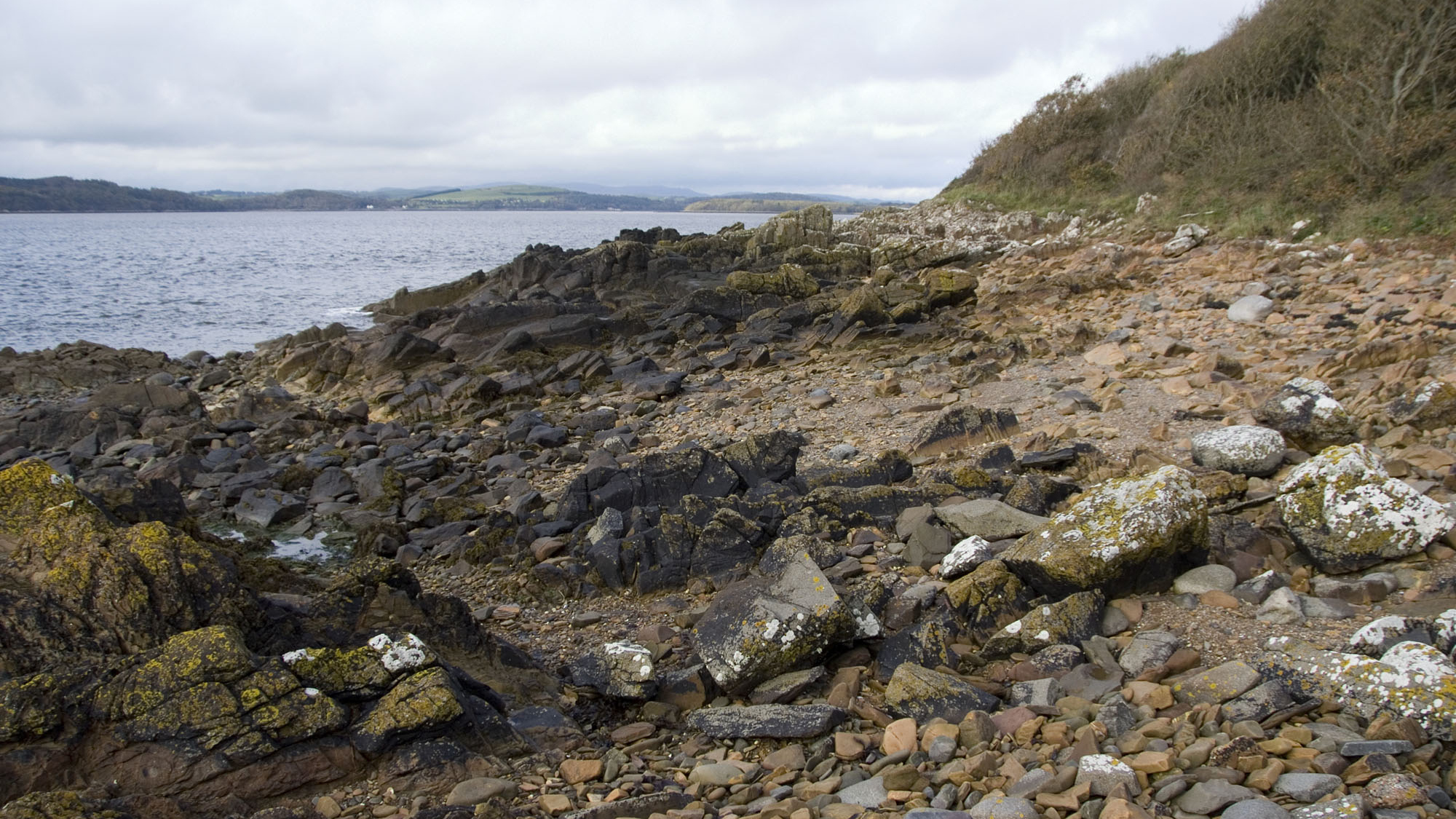
Overview
Directions
- From Kirkcudbright follow the A711 south to Mutehill. Where the main road bends east, take the minor road continuing south beside the estuary. Follow the coastal approach towards the lifeboat station, taking the right-hand fork described in the Council walk route.
- The Kirkcudbright Bay Paths guide records limited layby parking at NX 682476 for its shorter, approximately 5-mile walk. Use only lawful available spaces; this is not a guarantee of parking. A longer walk starts in Kirkcudbright, with Harbour Square identified in the Council route.
- Continue on foot along the lifeboat-station track. Do not park on or obstruct this private track: emergency vehicles need access at all times. Beyond the station, the original guide describes a small bay followed by the larger Long Robin bay.
- Return to the coastal path and follow the woodland and grassy route towards Torrs Point. Use the established paths and assess safe shore access locally; a bay-side path does not guarantee an escape from every ledge at rising tide.
- Original approach reference: 54.80421°N, 4.05377°W. This marks the approach, not a specific fossil bed or a guaranteed parking place.
Location photographs
Swipe to browse · Select a photograph to enlarge


Fossil Hunting
This guide covers Long Robin, the shore towards Witchwife’s Haven and Torrs Point. The main interest is graptolites in dark, finely laminated siltstone and mudstone between sandstone beds. Graptolites were colonial animals; their flattened remains can look like small black or silvery lines, curved strokes or saw-edged branches on a bedding surface. A hand lens and light held at a low angle are more useful than judging a wet, freshly broken surface at a glance.
At Long Robin, concentrate observation on naturally exposed fine-grained layers and loose pieces whose surfaces can be examined without damage. The sandstone and shale alternate repeatedly, and only some fine beds carry recognisable fossils. Do not assume every dark seam is fossiliferous, or that a loose slab came from the nearest exposed seam. Photograph the rock, its natural surface and the wider position before interpreting a find; extraction or retention needs the permissions described below.
Published Long Robin samples include Monograptus priodon, Monograptus minimus cautleyensis, monoclimacid graptolites and retiolitids. The fine, net-like framework of a retiolitid may be much less obvious than a solid-looking monograptid fragment. Records include Retiolites geinitzianus angustidens and Retiolites geinitzianus geinitzianus, using the determinations in the published study. A rare specimen compared with Cyrtograptus centrifugus was recorded as Cyrtograptus cf. centrifugus; this does not promise that a visitor will find a complete diagnostic index fossil.
Between Long Robin and Witchwife’s Haven, separate laminated horizons contain the Monograptus riccartonensis assemblages used to date the shore. Some are middle and others upper parts of the biozone, repeated by geological structure rather than forming an easy north-to-south staircase. Monograptus firmus sedberghensis is documented in this sector, while the nearby Torrs samples contain material recorded only as Monograptus cf. firmus sedberghensis. Identification often depends on details of the small cups along a branch and on an associated assemblage, so a curved fragment alone is not a secure species identification.
Historic descriptions record fragmentary straight-shelled, or orthoconic, cephalopods at Witchwife’s Haven and Torrs Point. These are a secondary research interest rather than an assurance of regular finds. A trace fossil, Protovirgularia, is also recorded in grey-green laminated mudstone about 300 m north of Torrs Point. A trace records activity in sediment and should not be labelled as a crustacean body fossil or attributed confidently to a particular animal from its name alone.
Microscopic acritarchs and recycled older microfossils reported by laboratory studies are discussed in the detailed geology; they are not a realistic hand-lens collecting target. Balmae Ha’en, Howwell Bay and Mullock Bay are separate military-estate localities farther south-east. Do not extend this route into their shore exposures without advance agreement on safe access and collection.
Discoveries and milestones
A chronological record of geological research and fossil documentation on the Long Robin–Torrs Point shore.
1853 – The east-bay structure is described
Robert Harkness published a detailed coastal section extending from Netherlaw Point through Balmae and north along the east side of Kirkcudbright Bay to Cutters Pool. His account documented inclined and vertical strata and repeated folds across a section encompassing this shore. Later work revised his explanations of how the rocks formed and were folded.
1899 – Graptolite bands and cephalopods are documented
Benjamin Peach and John Horne described recurring graptolitic bands from Long Robin towards Balmae Burn, limestone nodules near Witchwife’s Haven and fragmentary orthoconic cephalopods at Witchwife’s Haven and Torrs Point. This publication preserves local fossil and horizon records; it is not a date for the first discovery of each fossil.
1967 – Current indicators in Torrs Point sandstone are investigated
Kevin Scott studied changes in sedimentary directional indicators between the undersides and interiors of individual turbidite beds, with Torrs Point among the sections examined. The work connected features visible in the sandstone with movement of sediment-laden water.
1975 – The Ross Formation is formally named
C. M. Clarkson, G. Y. Craig and E. K. Walton formally defined the Ross Formation during their study of the rocks bordering Kirkcudbright Bay. The name remains applicable to Long Robin and Torrs Point, although later research revised aspects of the wider age and structural framework.
1982 – A local trace-fossil record enters a systematic review
Michael Benton’s Southern Uplands study listed Protovirgularia from grey-green laminated mudstone north of Torrs Point, drawing on the older locality record. The study placed the occurrence within a wider account of traces left in ancient ocean-floor sediments.
1985 – The Long Robin facies and east-bay structure are examined in detail
Alan Kemp’s research included a measured Ross Formation log at Long Robin, showing thin sandstone, siltstone and mudstone alternations with hemipelagite interbeds. Related work with Dennis White used new fossil ages and remapping to revise the organisation of the east-bay tectonic blocks.
1991–1992 – Graptolite and microfossil ages are refined
Dennis White, Hugh Barron, Robert Barnes and Byron Lintern published georeferenced fossil records that helped distinguish repeated tectonic slices along the coast. Their work documented Long Robin graptolites and acritarchs, together with older microfossils recycled into Torrs Point sediment. The paper belongs to the 1991 journal volume and is commonly cited as 1992.
1993 and 2000 – Modern mapping and a district synthesis bring the evidence together
The Geological Survey’s solid-geology editions of the Kirkcudbright and Dalbeattie sheets appeared in 1993. Byron Lintern and James Floyd’s 2000 district memoir integrated that mapping with the fossil coordinates and structural evidence, explaining why the east-bay exposures cannot be read as one simple upright succession.
Geology
The Long Robin–Torrs Point shore exposes the Ross Formation of the Hawick Group. These Silurian rocks record deposition close to the Llandovery–Wenlock transition and during the early Wenlock. Older local accounts called the Long Robin graptolite assemblages basal Wenlock; modern correlation of the formal boundary is more nuanced, so the detailed fossil zones are more informative than assigning one precise numerical age to the whole shore.
Much of the rock is greywacke sandstone, deposited by sediment-laden density currents moving across a deep marine floor. Finer silt and mud accumulated between the sandier events. Thin-bedded packages alternate with larger sandstone bodies, while particularly fine laminated hemipelagites preserve some of the graptolite evidence. This is why the locality is better understood as alternating event deposits and background sediment than as an undivided thickness of fossil-bearing shale.
After burial, the succession was tightly folded, sheared and repeated in thrust slices during development of the Southern Uplands. Steep or near-vertical bedding is a conspicuous result, but a walk along the shore is not a simple journey upwards through successively younger beds. Repeated fossil zones and disrupted intervals separate more coherent packets of strata; distances along the coast cannot be converted into a reliable formation thickness.
Long Robin is especially useful for understanding thin turbidites and their fine interbeds, while the sandstones at Torrs Point preserve structures used to investigate ancient currents. Sand-volcano features south of Long Robin record water escaping from sediment, whereas nearby folds and shear fabrics record later deformation. Keeping those processes separate helps explain why similar-looking irregularities in an outcrop can have very different origins.
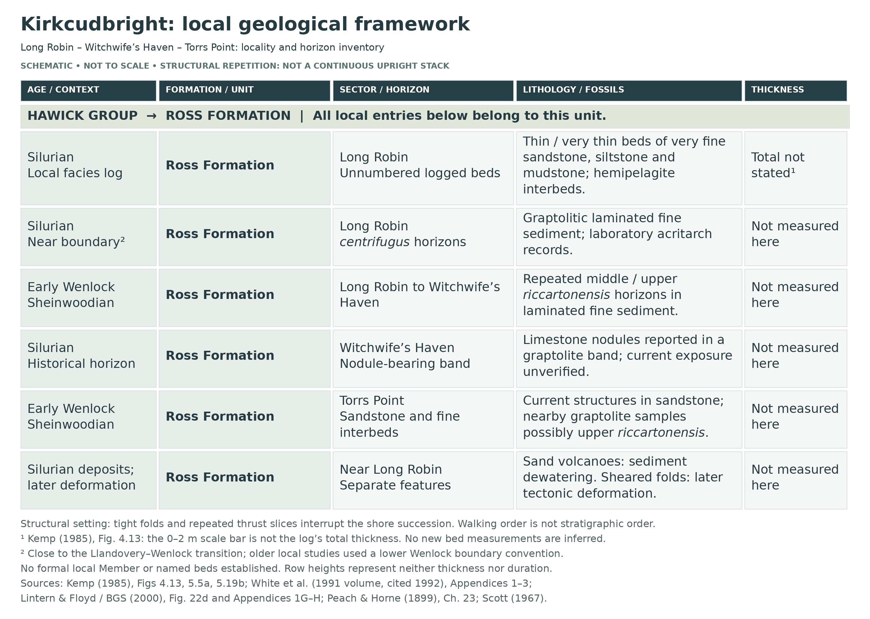
Detailed geology and bed-by-bed succession
Detailed Ross Formation horizons, the Long Robin log and the structural repetition of the Kirkcudbright shore.
The following account distinguishes observed local beds, fossil-sample horizons and wider formation context. It is not one continuous measured vertical section. Published sample numbers identify collecting localities, not numbered beds; no formal member subdivision is established for this guide’s shore.
HAWICK GROUP
The current British Geological Survey hierarchy places the Ross Formation in the Hawick Group. Earlier publications used Riccarton Group or informal tectonostratigraphic blocks, including Kemp’s Long Robin Block and Ross Block. These historical labels are useful in following the research but are not additional formal members.
Ross Formation
Greywacke sandstone alternates with siltstone, mudstone and graptolitic laminated hemipelagite. The local fossil sequence includes the Cyrtograptus centrifugus and Monograptus riccartonensis biozones. Ross Formation hemipelagite interbeds are reported more widely as commonly 0.1–1.5 m thick, with laminae of 0.1–10 cm; these are formation-wide facies ranges, not measurements of the individual visitor-site beds. Regional package thicknesses and estimates for the whole formation must likewise not be substituted for a measured Long Robin–Torrs thickness.
Long Robin logged section, NX 6734 4587. Kemp’s 1985 Figure 4.13 is an actual local sedimentary log. It shows unnumbered thin to very thin alternations of very fine sandstone, siltstone and mudstone, with larger individual sandstone bodies alternating with packets of much thinner beds. In the drawn section, a lower sandier portion passes into a finely alternating package; a conspicuous pair of larger sandstone bodies interrupts that finer succession, followed by another thin-bedded package. These are descriptive positions within the illustrated log, not newly named units or a claim that the whole coastal succession has this simple order.
Two explicitly hatched hemipelagite interbeds appear in the log, one within the middle thin-bedded package and another within the upper package. They represent finer background sediment between density-flow deposits. The figure gives a 0–2 m scale bar, not a 2 m total section thickness, and prints no individual bed thicknesses or formal internal bed names. No particular fossil sample is assigned to either hatched bed. The local log documents meaningful facies variation without establishing the full formation thickness or an uninterrupted Llandovery–Wenlock boundary section.
Long Robin centrifugus-biozone horizons. White and colleagues’ localities 16–22 extend from NX 6735 4586 to NX 6732 4565, with six zonally assigned samples and one uncertain assignment. Fossils occur in laminated fine sediment rather than in a single formally named bed. Records include Monograptus priodon, Monograptus minimus cautleyensis, Monoclimacis vomerina sensu lato and its named subspecies, Cyrtograptus species and retiolitids. Retiolites geinitzianus angustidens occurs at locality 17 (NX 6733 4586), and Retiolites geinitzianus geinitzianus at locality 20 (NX 6731 4569). The source records Cyrtograptus aff. insectus at locality 17, with an uncertain further record at 16; Cyrtograptus cf. centrifugus and Monograptus remotus occur at locality 22. The same study records Monograptus aff. priodon at localities 17–19. Its monoclimacid determinations distinguish Monoclimacis vomerina vomerina at 17 from Monoclimacis vomerina basilica at 18 and 22, with cf. records of the latter at 17, 20 and 21. Monoclimacis vomerina sensu lato occurs at 16, 18 and 20–22. These comparison and broad-sense qualifiers remain part of the published identifications.
The zonal conclusion rests on the fossil assemblage, not on an unequivocal complete index specimen in every sample. Although the original local studies called this interval basal Wenlock, modern boundary correlation places the formal Wenlock base near the upper centrifugus to lower murchisoni interval. The older Long Robin horizons are therefore best described as close to the Llandovery–Wenlock transition. This qualification does not erase their observed biozone, and the local study did not firmly establish a murchisoni Biozone on this shore.
Repeated middle and upper riccartonensis horizons. Between Long Robin and Witchwife’s Haven, hemipelagic laminated siltstone and mudstone yielded White localities 23–31. Their geographic sequence includes uncertain or undivided assignments, an upper interval, a middle interval and another possibly upper interval. Locality 24 at NX 6729 4549 is upper riccartonensis; localities 25–29, from NX 6731 4542 to NX 6731 4526, belong to its middle part. Locality 31 at NX 6729 4521 is qualified as possibly upper in the relevant discussion. This pattern reflects structural repetition, not a single ascending stack or a succession of formal members.
Monograptus riccartonensis is recorded at localities 24–29, with a cf. identification at 23. Monograptus firmus sedberghensis occurs at 24, with a ? record at 23 and a cf. record at 31. Monoclimacis vomerina basilica is recorded at 29 and 31, with a cf. record at 25; Monoclimacis vomerina sensu lato occurs at 25 and 30. Other records include Pristiograptus cf. meneghini at 24, Monograptus cf. radotinensis inclinatus at 27 and the Pristiograptus dubius group at 30. These are published locality-specific determinations, not identifications of the guide photographs. Figured specimens from this shore are not automatically type specimens.
Witchwife’s Haven nodule-bearing graptolitic band. Peach and Horne’s 1899 account records limestone nodules in a graptolite band near Witchwife’s Haven. This historical horizon deserves separate recognition, but its exact present exposure, thickness, contacts and correlation to an individual later fossil sample are not established. It must not be merged with the shelly limestone and conglomeratic deposits farther south at Little Balmae and Gipsy Point. Their account also records fragmentary orthoconic cephalopods at Witchwife’s Haven and Torrs Point, without supporting a confident modern species list for those remains.
Torrs Point sandstone beds and fine interbeds. The core reference point is NX 6727 4490. Sandstone structures here were investigated for evidence of currents, including the relationship between basal sole marks and structures higher within individual beds. Cleavage-related grain alignment can complicate interpretation, so published multi-site current-rotation statistics should not be treated as a measurement for one Torrs bed. Fine interbeds carry the age evidence. Nearby graptolite localities 32 (NX 6730 4486) and 33 (NX 6740 4474) are assigned possibly upper riccartonensis and contain Monograptus cf. firmus sedberghensis. The latter point is near the military-estate boundary and is a historical research locality, not an unrestricted collecting instruction.
Dewatering and later deformation south of Long Robin. Kemp documents sand-volcano structures about 150 m south of Long Robin. These record the escape of water and sediment during dewatering. A sheared zone about 50 m south contains steeply plunging, sinistrally verging folds: those belong to later deformation. No supported bed number, measured thickness or one-to-one correlation with White’s fossil samples attaches to either occurrence. Observe these structures without damaging their surfaces.
Structural repetition and formation boundaries. Tightly folded beds and repeated thrust slices form the east-bay section, with coherent bedding packets alternating with disrupted zones. The BGS structural section places Torrs Point well within the Ross Formation and locates the Ross–Raeberry Castle boundary farther south-east, beyond Torrs Cove Bay and Balmae Haven in its coastal sequence. Carghidown Formation occurs farther north around the approach through Bathinghouse Bay; it is not another fossil layer inserted into the Long Robin log. Neither the across-bay Ross type section nor the Raeberry Castle members should be imported into this local succession.
Laboratory microfossils, kept separate from visible finds. Long Robin samples yielded the acritarchs Ammonidium wychense and Tylotopalla caelamenicutis at locality 16, and Ammonidium microcladum and Visbysphaera dilatispinosa at locality 21. At Torrs Point, sample 120 (NX 6727 4490) contains recycled early to middle Ordovician Stelliferidium; that older microfossil does not make the enclosing Ross Formation Ordovician. A single Ambitisporites spore was recorded at locality 33, the boundary-sensitive south-eastern point. These are microscopic laboratory records, not visible fossils promised to a casual collector; published spore illustrations from Mullock Bay and Big Raeberry must not be relabelled as Torrs specimens.
Historical “crustacean” records. The old Aptychopsis record immediately south of Torrs Cove Bay lies beyond the main guide footprint. Later studies associate aptychopsid plates with cephalopods, discussing jaw or protective-operculum interpretations. The historical label therefore does not establish a crustacean fauna at Long Robin or Torrs Point, and there is no basis here to assert a newly revised species identification for the individual old specimen.
References
Lintern, B. C. & Floyd, J. D. (2000), Geology of the Kirkcudbright–Dalbeattie district, chapters 4–5 and fossil appendices.
Kemp, A. E. S. (1985), Later (Silurian) sedimentary and tectonic evolution of the Southern Uplands accretionary terrain, especially Figure 4.13 and deformation/dewatering figures.
White, D. E., Barron, H. F., Barnes, R. P. & Lintern, B. C. (1991 volume, commonly cited 1992), Biostratigraphy of late Llandovery and Wenlock turbiditic sequences.
Peach, B. N. & Horne, J. (1899), The Silurian Rocks of Britain, Scotland, chapter 23.
Benton, M. J. (1982), Trace fossils from Lower Palaeozoic ocean-floor sediments of the Southern Uplands.
Scott, K. M. (1967), Intra-bed palaeocurrent variations in a Silurian flysch sequence.
BGS Lexicon: Ross Formation; Geological Society: Hughley Brook boundary correlation.
Stridsberg, S. (1984), Aptychopsid plates: jaw elements or protective operculum.
Safety
Plan the foreshore part for low water, check tide times and weather, and leave a generous return margin. Wet, steeply dipping sandstone and shale can be extremely slippery; avoid exposed edges, unstable blocks and routes below cliffs where escape is uncertain. Do not assume any part of the shore is safe from tidal cut-off. Wear grippy footwear, travel with company where possible and tell someone your route.
The main Long Robin–Torrs shore and lifeboat approach lie outside the military boundary shown on the latest MOD leaflet, but the south-eastern end is boundary-sensitive. Do not use the printed map to judge a precise boundary on the ground. Within the military estate, follow only the agreed mapped routes and all current signs: red flags or lamps mean no entry. Never touch military debris, and never take absent flags as permission to leave an approved route. Current access information is in the MOD leaflet updated in August 2026; its 24-hour contacts are Range Control 07717 542336 and Guard Room 07977 402291.
Equipment
Take sturdy boots with good grip, a hand lens, a camera, a small scale and a notebook or offline map for recording observations. Waterproof clothing and a charged phone are sensible on this exposed shore. A splitting pick is not part of an unrestricted visit: any sampling tools and quantities must be agreed in advance. If retaining material is authorised, carry soft wrapping and rigid containers to protect thin slabs and keep matching pieces together.
Cleaning And Treating
Graptolites may survive as delicate films on fine bedding surfaces. Do not scrub, wire-brush, varnish or acid-treat them, and avoid trying to open a protected bed to improve a photograph. Keep any authorised specimen and its counterpart together, with the precise locality, date and whether it came from a loose block or an observed horizon. Photograph fragile surfaces before handling further. Seek specialist preparation advice for important material rather than using a general treatment intended for robust shells in limestone.
Identify Your Finds
Need help identifying a fossil? Share clear photos, where you found it and its size with the community.
Further Reading
BGS: Geology of the Kirkcudbright–Dalbeattie district
Kemp: local sedimentary logs and structure
White and colleagues: graptolite and microfossil biostratigraphy
Peach and Horne: historical east-bay observations
GCR: British Silurian Stratigraphy, including the wider Balmae Coast
MOD: current Kirkcudbright access route and safety leaflet
NatureScot: Scottish Fossil Code
Access Rights
The Long Robin–Torrs shore lies within Torrs to Mason’s Walk Site of Special Scientific Interest, and forms part of the wider Balmae Coast geological conservation locality. Seek the landowner’s permission before extracting, collecting or retaining fossils; where mineral or fossil rights are separately held, obtain the relevant rights holder’s permission too. Walking access does not itself confer a right to remove fossils. No general collecting consent for this shore has been established.
Agree any proposed sampling with the landowner and establish the NatureScot consent required before work starts. Bedrock collection within an SSSI requires NatureScot consent, and in some circumstances loose material does too. Until the permissions for your activity are clear, observe and photograph exposed fossils and examine loose material without taking it. The Scottish Fossil Code supports responsible collecting; protected-site safeguards should not be confused with a blanket ban on fossil collecting throughout Scotland.
Military access is a separate requirement from fossil-collecting permission. The main approach and shore must not be treated as closed merely because the range lies nearby, but Balmae Ha’en, Howwell Bay and Mullock Bay are within the estate. The latest leaflet permits access on agreed mapped routes only when flags and lamps allow; it does not open the fossil bays as unrestricted shore detours. Obtain advance agreement for any visit beyond those routes and for any collection, and follow current Range Control instructions.

Read and follow the Scottish Fossil Code for all Scottish sites. Leave important structures intact, record any significant find and seek advice before attempting extraction.
It is important to follow our Code of Conduct when collecting fossils or visiting any site. Please also read our Terms and Conditions.
Links
♦ Fossil Discussions
♦ Fossil Articles
♦ Buy Fossils, Tools and Equipment
♦ Buy Crystals, Meteorites, and Artefacts
♦ Join Fossil Hunts
♦ UK Fossils Network


