
Overview
Directions
- Use the signed Lulworth Cove visitor car park and established road down to the shore. The visitor-centre area provides the main orientation; check current facilities and parking notices.
- View Stair Hole from maintained public paths. The Fossil Forest is a separate walk east along the signed coast path and down designated steps, only when MOD public-opening notices and local access permit.
- Check current range notices, gates, signs and flags. Do not rely on the old telephone number or historic Sunday and holiday opening pattern, and do not attempt to reach the Forest along the beach around the entrance cliffs.
- Original geological locality reference: 50.61866°N, 2.24977°W. This is not a verified parking or descent point.
Location photographs
Swipe to browse · Select a photograph to enlarge


Fossil Hunting
Fossils are less readily available at Lulworth than at many western Dorset beaches. The Purbeck beds record oysters, freshwater bivalves, gastropod-rich limestone and ostracods, with occasional fish material. Younger marine units contain shells, echinoids and ammonites, but nineteenth-century species lists require modern verification.
The softer Wealden ground is commonly slipped and is not a reliable easy source of fossils. Hard limestone at the cove entrance also should not be broken. Observe naturally visible surfaces from safe positions and keep records from the cove, Stair Hole and Fossil Forest distinct.
At the Fossil Forest, tree moulds and microbial limestone structures record vegetation followed by flooding and carbonate growth. Leave all features intact. It is a separately accessed, range-controlled locality, not a beach walk around the entrance cliffs.
Follow Lulworth Estate’s code: leave rocks and stones on the beach, do not hammer the cliffs and report important finds at the Visitor Centre. Regional Durlston mammals, Swanage reptiles and the 2014 quarry cone discovery should not be attributed to this cove. Photographs and accurate location notes are the useful outcome of a visit.
Fossil photographs
Swipe to browse · Select a photograph to enlarge


Discoveries and milestones
A chronological record of geological research and discoveries associated with Lulworth Cove.
Before 1880 – Silicified trees collected
The BGS memoir records exquisitely preserved silicified tree remains from the Lulworth Fossil Forest before 1880. Today the conspicuous structures are mostly hollow moulds and microbial carbonate around former trunks; this history explains why the site is not a source of freely removable fossil trees.
1884 – An influential cove section
Damon’s account, drawing on Bristow’s measurements, helped establish the traditional local Purbeck succession. Its bed names remain useful, but some thicknesses and ranks were subsequently revised.
1964–1975 – Evaporites and deformation investigated
West’s investigations identified evidence of former evaporite minerals in the Broken Beds and explored the roles of replacement and deformation. These studies helped explain why the breccia is more complex than an ordinary limestone rubble layer.
1996 – Modern Purbeck hierarchy formalized
Westhead and Mather’s framework separated the Lulworth and Durlston formations into five mapped members. It places the Cinder Bed in the Stair Hole Member of the Durlston Formation and retains traditional smaller divisions as beds.
2015–2020 – Fossil Forest access repaired
A 2015 rockfall damaged the access steps. Repairs were documented in 2019, and the Dorset landscape partnership announced reopening from 21 March 2020. Present access still depends on MOD public-opening notices and current local conditions.
Geology
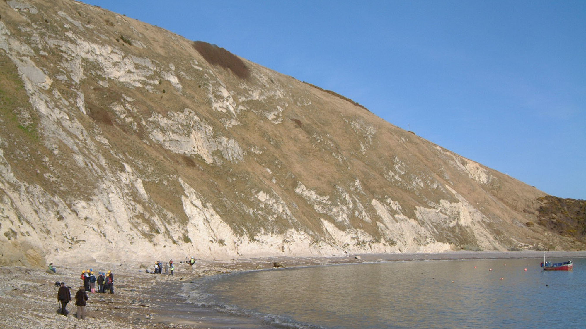
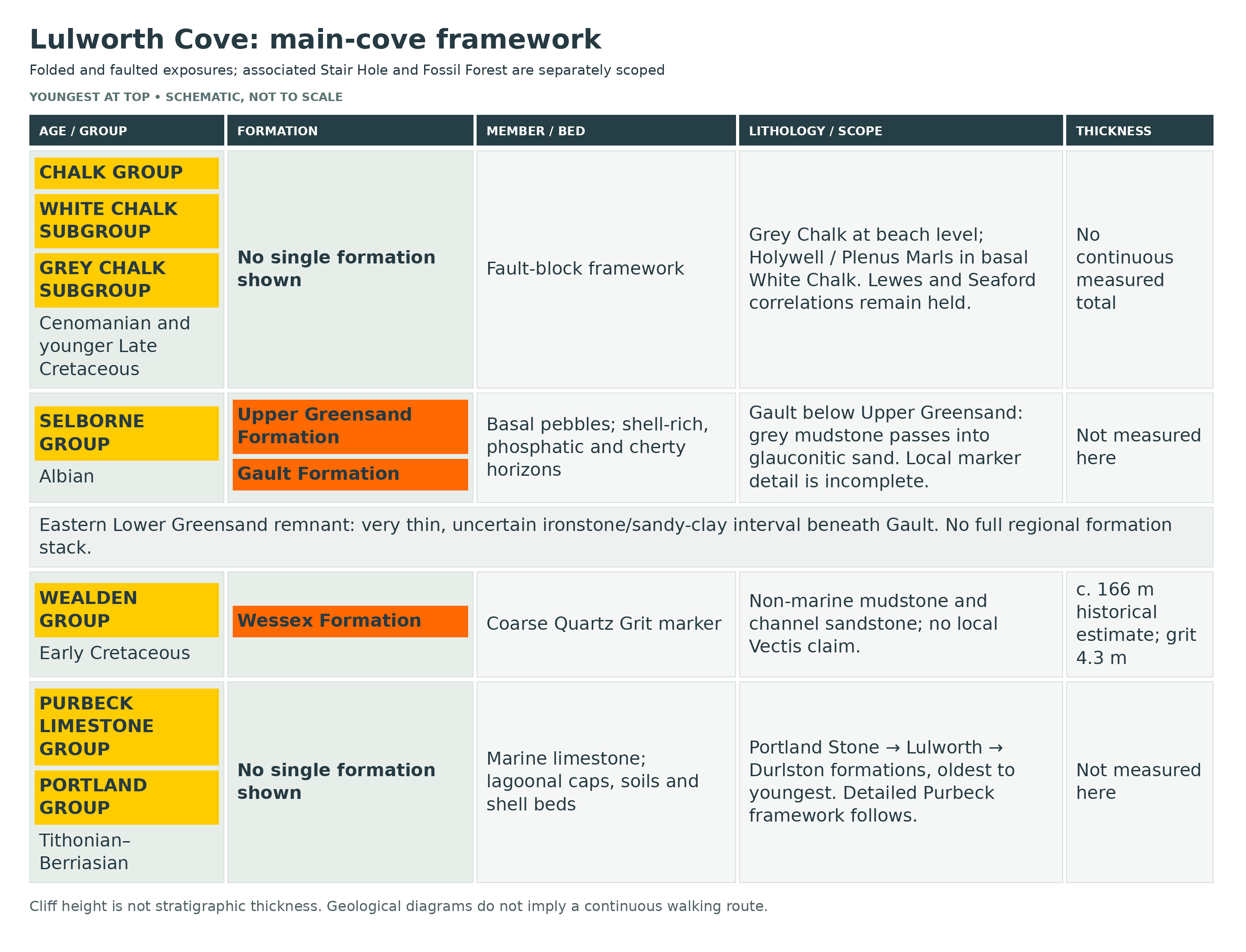
The sea breached a resistant Portland limestone barrier and eroded the softer rocks behind it, producing the cove’s narrow entrance and broad interior. Portland Stone forms the entrance horns; Purbeck and Wealden rocks, followed by Gault and Upper Greensand, occupy the intervening ground before the Chalk at the back.
The Purbeck Limestone Group records saline lagoons, freshwater conditions, emergence and renewed marine influence. Modern formations and members organise the traditional local bed names below. The oyster-rich Cinder Bed marks the base of the Durlston Formation, not part of the Lulworth Formation as the original guide stated.
Stair Hole, the east-cove historical section and the separately accessed Fossil Forest are related but distinct exposures. Historical measurements and conflicting totals are retained with their limitations rather than combined into a falsely precise column. The Fossil Forest’s rooted surfaces and microbial structures belong to the basal cap-and-soil succession.
Steep bedding, faults and locally overturned Chalk complicate the back cliffs. Plenus Marls belongs in the basal Holywell/White Chalk framework; faults can remove or repeat it. Neither a regional Chalk thickness nor the complete neighbouring Dungy Head log should be substituted for the cove’s disturbed section.

Detailed geology and bed-by-bed succession
The detailed geological succession and important exposure limits at Lulworth Cove.
The narrow limestone entrance, softer inner succession and faulted Chalk explain the cove’s form. Traditional Purbeck bed names are retained beneath the modern BGS hierarchy. Historical local measurements are labelled, inconsistencies are preserved and adjacent-section measurements are excluded.
PORTLAND GROUP
Late Jurassic shallow-marine limestone forms the resistant entrance horns of the cove. Exposure positions, not the apparent vertical height of the folded cliffs, determine stratigraphical order.
Age: Tithonian
Portland Stone Formation
The marine limestone barrier is breached at the narrow mouth. Chert-bearing and upper building-stone lithologies are distinguishable, but the complete neighbouring Dungy Head or Portland logs are not copied into this cove.
Portland Chert Member
The lower limestone member is part of the entrance succession. Named Dungy Head/Puffin Ledge details belong to the adjacent headland section and require a specific cove correlation before inclusion here.
Portland Freestone Member
Upper marine limestone beneath the basal Purbeck beds records shallow carbonate-sand deposition. Locally weathered and eroded upper surfaces precede the soils and lagoonal caps.
PURBECK LIMESTONE GROUP
The succession records saline lagoons, exposed soils, freshwater lakes and repeated marine influence. BGS uses two formations and five mapped members; the many traditional names below are beds or informal intervals, despite being called members on older web pages.
Age: Latest Tithonian–Berriasian
Lulworth Formation
The lower formation extends from basal cap-and-soil beds to the top of the Cherty Freshwater Beds. It ends below the Cinder Bed. Measurements below come from West’s historical east-cove synthesis unless separately labelled; they are not all new modern measurements.
Mupe Member
Caps, dirt beds, Broken Beds and the lower part of the Cypris Freestones belong here. The Fossil Forest is a separately accessed associated exposure of the basal interval. Its beds must not be confused with the cliff-top quarry caps on Portland.
Lower Dirt Bed and Hard Cap
West’s local historical section groups these as 1.37 m. The thin soil is overlain by laminated and locally oolitic microbial limestone; polygonal tepee structures and evidence of former evaporites record episodes of emergence and saline-water deposition.
Great Dirt Bed
A thin pebbly carbonate-rich palaeosol supported trees. The Fossil Forest moulds record trunks rooted at this level; many actual woody remains were removed or lost long ago. Thickness is variable, approximately 0.15 m in the old local section.
Soft Cap, lower microbial division
Microbial carbonate grew around inundated tree remains, preserving the familiar ring-shaped moulds. Use microbial growth rather than assuming every structure is a solid petrified trunk or a purely freshwater deposit.
Soft Cap, upper evaporitic division
The upper division preserves evidence of former anhydrite/gypsum and lamination. The two Soft Cap divisions total 1.52 m in the historical local account.
Lower Broken Beds
Angular limestone fragments lie in a porous calcitized evaporite matrix. Dissolution, replacement and deformation all complicate its history; no single mechanism fully explains the breccia.
Upper Broken Beds
Angular ripple-laminated limestone blocks have much less matrix than the lower division. The combined breccia is about 3 m but strongly variable in the local historical description.
Lower Cypris Freestones
Ripple-laminated, ostracod-rich limestone succeeds the breccia. The traditional interval spans more than one modern member, so its whole reported thickness extends beyond the Mupe Member.
Ridgeway Member
Mudstone and micritic limestone above the Mupe limestones correspond to the upper Cypris Freestones/Lower Insect Beds in the BGS correlation. The exact cove boundary cannot be recovered from the old undivided thickness alone.
Upper Cypris Freestones and Lower Insect interval
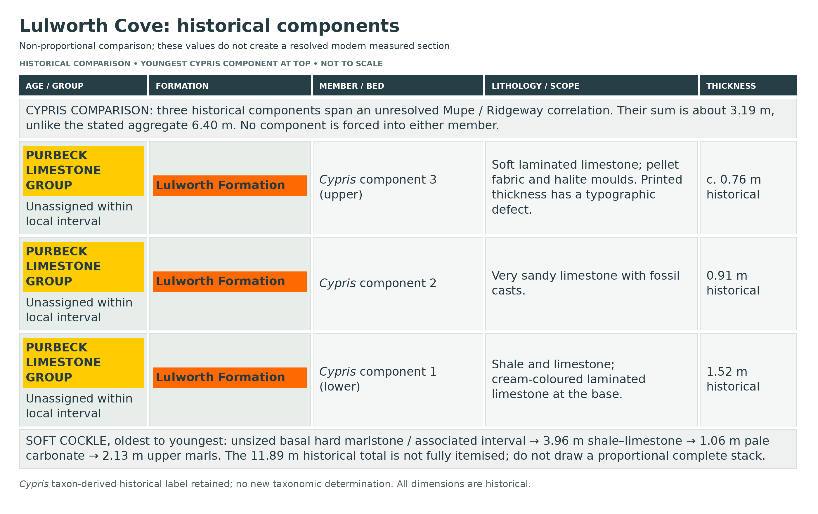
These traditional names are correlation aids rather than evidence that regional isopod, insect or gastropod species occur in this exact cove bed. West’s aggregate Cypris total and listed subunits do not fully reconcile, so a reliable numerical sub-bed succession remains unresolved. The separately listed historical components sum to about 3.19 m, unlike the stated 6.40 m aggregate; their incomplete correlation is preserved and none is forced across the Mupe/Ridgeway boundary.
Historical Cypris component 1: lower shale and limestone
West lists shale and limestone with cream-coloured laminated limestone at the base, 1.52 m. These components are an incompletely reconciled historical interval, not individually assigned across the Mupe/Ridgeway boundary.
Historical Cypris component 2: sandy limestone
Very sandy limestone with fossil casts is listed as 0.91 m. Its precise modern member correlation remains unverified.
Historical Cypris component 3: upper laminated limestone
Soft laminated limestone has pellet fabric, halite moulds and reported ostracods and gastropods. The defective printed value “).76 m” is read approximately as 0.76 m, not silently treated as an exact modern measurement.
Worbarrow Tout Member
The formal member begins with the Hard Cockle Beds and ends at the top of the Cherty Freshwater Beds. The local beds reflect changing lagoon salinity and repeated emergence.
Age: Berriasian
Hard Cockle: basal sandy shale
A 0.60 m sandy shale forms the lowest division in the historical east-cove list. Sand lenses record small-scale bedforms.
Hard Cockle: shelly limestone
The overlying 1.83 m contains abundant cockle-shell debris, historically assigned to Protocardia purbeckensis.
Hard Cockle: yellow sandy limestone
A conspicuous yellow-weathering, ripple-marked 0.60 m limestone occurs above the shell-rich beds.
Hard Cockle: upper fissile limestone
The upper division contains fissile and locally honeycombed limestone with a shale parting. Its listed 1.21 m and the other components sum to 4.24 m, whereas the source gives 4.26 m overall; the minor historical rounding discrepancy remains unresolved.
Soft Cockle Beds
Soft marl, shale and limestone with salt-crystal moulds record saline lagoon conditions. The old local total is 11.89 m, but the detailed components are incomplete. The substantial gypsum bed recorded at Worbarrow/Durlston is absent from the thinned Lulworth section, as West explicitly notes.
Soft Cockle basal hard marlstone and unsized interval
The lowest hard marlstone contains cavities lined with silica and calcite, interpreted as relics of evaporites. Associated hard and soft marl, grey shale and limestone are described without a separate thickness. This unsized interval prevents a complete proportional reconstruction.
Soft Cockle lower shale–limestone interval
A 3.96 m division includes shale, limestone, mudclast-bearing material and salt pseudomorphs. These listed components do not cover the entire interval and do not constitute a complete measured log.
Soft Cockle pale limestone/dolomite interval
A 1.06 m pale carbonate interval with shale partings contains halite moulds; the precise mineralogy at this cove was not established in the field account.
Soft Cockle upper marls
The old list distinguishes about 2.13 m of harder and softer marls near the top.
Marly Freshwater Beds
Grey shale, marlstone and argillaceous limestone include a pale variegated carbonate bed historically reported as 0.76 m with fish remains and small gastropods. The local total is 3.81 m; the famous Durlston Mammal Bed is not a demonstrated Lulworth fossil horizon.
Cherty Freshwater Beds and Flint Bed
Freshwater-associated carbonate and shale include a conspicuous pale blocky cherty limestone. The historical local total is 1.75 m. The separately quoted 0.68 m Flint Bed thickness is specifically Stair Hole and does not establish its thickness in the east-cove section.
Cherty Freshwater upper dark sandy shales
West separately describes approximately 0.60 m of dark sandy shale at the top of this historical interval. This is distinct from the 0.68 m Flint Bed measurement explicitly taken at Stair Hole.
Durlston Formation
This formation begins at the base of the oyster-rich Cinder Bed. The original guide incorrectly assigns that bed to the Lulworth Formation.
Age: Berriasian
Stair Hole Member
The member encompasses the Cinder, Intermarine, Scallop, Corbula and Chief Beef beds in the modern BGS scheme. Traditional finer subdivisions are not parallel formal members.
Hard Cinder
The lower, harder oyster-rich limestone is 0.76 m in the historical local synthesis. The oyster is conventionally recorded as Praeexogyra distorta; echinoid remains support increased marine influence.
Soft Cinder
A more argillaceous oyster-rich upper division is 0.46 m, giving 1.22 m for the two local Cinder divisions. This is an Early Cretaceous marine-influenced horizon, not the modern Jurassic–Cretaceous boundary.
Intermarine Beds
Shell-debris limestone and pyritic shale, locally with fibrous calcite, reflect brackish-water deposition. The historical local total is 2.29 m and includes approximately a metre of central shale. Regional dinosaur footprints are not assigned here without a local specimen record.
Scallop Beds
A 0.59 m shelly limestone contains scallops and records a renewed interval of stronger marine influence.
Corbula Beds
Limestone and shale total 4.57 m in the local historical account. It mentions a 0.53 m hard fish-spine-bearing limestone, but the exact modern taxonomic identification of those remains is not independently checked here.
Chief Beef Beds
Dark shale with shell-limestone bands and fibrous calcite veins totals 2.51 m in the historical list. “Beef” is a diagenetic calcite fabric, not a fossil.
Peveril Point Member
The upper Purbeck member begins with Broken Shell Limestone and continues through freshwater shell-rich limestone and carbonaceous mudstone to the last substantial limestone below the Wealden.
Broken Shell Limestone
Coarse shell-debris limestone at the member base is 1.06 m in the historical cove account, with fish remains and small gastropods reported.
Unio interval
Greenish glauconitic shell-rich strata overlie Broken Shell Limestone. West says the local interval is less than one metre while retaining a historical 1.14 m figure in the table; the discrepancy remains unresolved.
Upper Ostracod Shales and Purbeck Marble horizons
The upper succession contains carbonaceous shale, thin gastropod limestone and freshwater bivalves. West’s local aggregate is 4.8 m, but its illustration of marble is from Peveril Point; do not miscaption that image as Lulworth.
WEALDEN GROUP
The former “Wealden Formation” map unit is now treated at group rank in the modern framework. The cove’s non-marine succession is much thinner than at Swanage.
Wessex Formation
Variegated mudstone and channel sandstone are poorly fossiliferous and commonly slipped. A historical local estimate is about 166 m; it is not a bed-perfect modern total. Vectis is not independently demonstrated here.
Age: Early Cretaceous
Coarse Quartz Grit
A 4.3 m coarse sandstone marker is described near the middle of the local Wealden succession. It is a useful field reference without importing a Swanage bed number.
LOWER GREENSAND GROUP: THIN EASTERN REMNANT
A very thin uncertain ironstone/sandy-clay interval occurs below the Gault on the east side. The BGS memoir estimates about 0.5 m locally and notes the modern group rank; a full local succession of Atherfield, Ferruginous and Sandrock units is not established.
Age: Aptian context; exact thin remnant poorly constrained
Impersistent fossiliferous ironstone
West describes a roughly 0.15 m impersistent band about 0.30 m below the basal Gault pebble bed, with poorly preserved shells. The assignment of some underlying clay and sand is uncertain. This is not a rich or complete Lower Greensand section.
SELBORNE GROUP
The marine Gault and Upper Greensand belong to the Selborne Group.
Gault Formation
Weathered grey marine mudstone with a basal pebble bed passes upward into sandier strata. The section is structurally reduced and prone to slipping; no regional fossil list is converted to guaranteed local finds.
Age: Albian
Basal Gault pebble bed
Rounded quartz and dark chert pebbles identify the marine transgression. This marker is distinct from the younger phosphatic Chalk basement.
Upper Greensand Formation
Glauconitic sandstone and siltstone include shell-rich, phosphatic and cherty horizons. The approximately 40 m figure in West is for the local area rather than a new exact cove measurement.
Age: Predominantly Albian locally
Exogyra Rock
The conspicuous shell-rich sandstone contains oysters historically called Exogyra obliquata or E. conica. West gives approximately one metre in the Lulworth area; do not substitute the thicker development elsewhere.
Three argillaceous beds above Exogyra Rock
West records three softer beds, each approximately one metre. The middle includes large nautiloids; the top is the Ammonite Bed. The source does not supply a complete modern measured sub-bed log.
Ammonite Bed
The upper of those three argillaceous horizons contains ammonites, commonly affected by phosphatization or weathering. Old species lists require exact collection provenance before expansion.
Upper chert beds and terminal boulder bed
Chert-bearing sandstone is capped by a distinctive concentration of glauconite-coated clasts, recording condensation and erosion near the top of the Greensand succession.
CHALK GROUP
Chalk forms the back of the cove, with steep bedding, faults and overturned upper strata. It is a structural section, not an uninterrupted pile inferred from cliff height.
Age: Late Cretaceous
GREY CHALK SUBGROUP
Cenomanian marly/purer chalk cycles and a phosphatic basal horizon are present at beach level. West reports only about 10 m surviving locally through faulting; do not substitute the regional 57 m total or assume every lower Chalk formation is complete.
Age: Cenomanian
Basal Chalk phosphatic horizon
Glauconite and brown phosphatic nodules, including reworked fossil material, occur at the base. Ammonite age cannot be inferred from a beach-worn specimen without matrix and provenance.
WHITE CHALK SUBGROUP
Higher nodular and flinty chalk occurs above and across faults. The local bed-level correlations remain insufficiently verified.
Holywell Nodular Chalk Formation
The original geological account identifies this basal White Chalk unit and notes fault truncation around the Plenus Marls. Plenus Marls belong within the basal White Chalk/Holywell framework, not automatically to Grey Chalk because older literature called them the top of Lower Chalk. The exact thickness preserved locally remains unverified.
Age: Latest Cenomanian–early Turonian
Plenus Marls Member
This basal Holywell unit is recognized at cove beach level in the original guide but is locally cut out or disturbed by faults. A complete eight-bed local succession and its thickness have not been established.
Age: Latest Cenomanian
Lewes Nodular Chalk Formation
The original guide identifies a higher faulted slice in the back cliffs. Its independent correlation and the thicknesses of the intervening formations remain unverified.
Age: Turonian–Coniacian regional formation range
Seaford Chalk Formation
Higher flinty chalk is identified in the original back-cliff description. The bed-level boundary and retained local thickness remain to be checked independently.
Age: Coniacian–Santonian regional formation range
References
Bgs Chalk Framework
Bgs Dorset Memoir
Bgs Lulworth Lexicon
Bgs Mupe
Bgs Peveril
Bgs Portland Chert
Bgs Portland Freestone
Bgs Portland Stone
Bgs Ridgeway
Bgs Selborne
Bgs Stairhole
Bgs Wessex Lexicon
Bgs Worbarrow Tout
Cinder 2026
Forest Reopen
Forest Repairs
Gov Lulworth
Lulworth Collecting
Lulworth Firing
Lulworth Forest
Lulworth Geology
West Lulworth Strata
Safety
Stay clear of cliff bases, overhangs and recent falls, including the dangerous eastern Purbeck overhang. Do not climb fixed rocks to reach a marker bed or enter caves. Tide, wind and swell affect safe retreat; a fixed three-hour rule cannot guarantee access. Supervise children on the main beach and assess the longer stepped Forest walk separately. Never enter a firing area or pass closed barriers.
Equipment
Bring a camera, scale and notebook, with suitable footwear and current access information. Leave collecting tools at home. Assess supplies and the return climb separately for the longer Fossil Forest walk.
Cleaning And Treating
Record important finds in place and tell the Visitor Centre. For legally held material from earlier collections, retain labels and supporting matrix and seek specialist preparation advice. Do not use strong acids or power tools on site, and never prepare or damage the fixed Fossil Forest structures.
Identify Your Finds
Need help identifying a fossil? Share clear photos, where you found it and its size with the community.
Further Reading
Ian West: detailed Lulworth strata
BGS South Dorset memoir
BGS Lulworth Formation
BGS Stair Hole Member
Lulworth Estate fossil code
Lulworth Estate Fossil Forest access
MOD current Lulworth firing notices
Dorset landscape partnership: 2020 Forest reopening
DIO: 2019 access repairs
Radley and Coram 2026 Cinder reef paper, abstract-only research lead
Access Rights
Follow the Lulworth Estate code: stay away from cliffs, do not hammer them, leave rocks and stones on the beach and report scientifically important finds at the Visitor Centre. At the Fossil Forest do not remove or damage any feature. MOD range access is governed by current public-opening notices, gates, signs and flags; remain on marked paths and do not touch suspicious objects. Use the current schedule for the day of your visit rather than relying on an older opening pattern.
Protected-site information: SSSI Information – South Dorset.
It is important to follow our ‘Code of Conduct’ when collecting fossils or visiting any site. Please also read our ‘Terms and Conditions’.
Links
♦ Fossil Discussions
♦ Fossil Articles
♦ Buy Fossils, Tools and Equipment
♦ Buy Crystals, Meteorites, and Artefacts
♦ Join Fossil Hunts
♦ UK Fossils Network


