

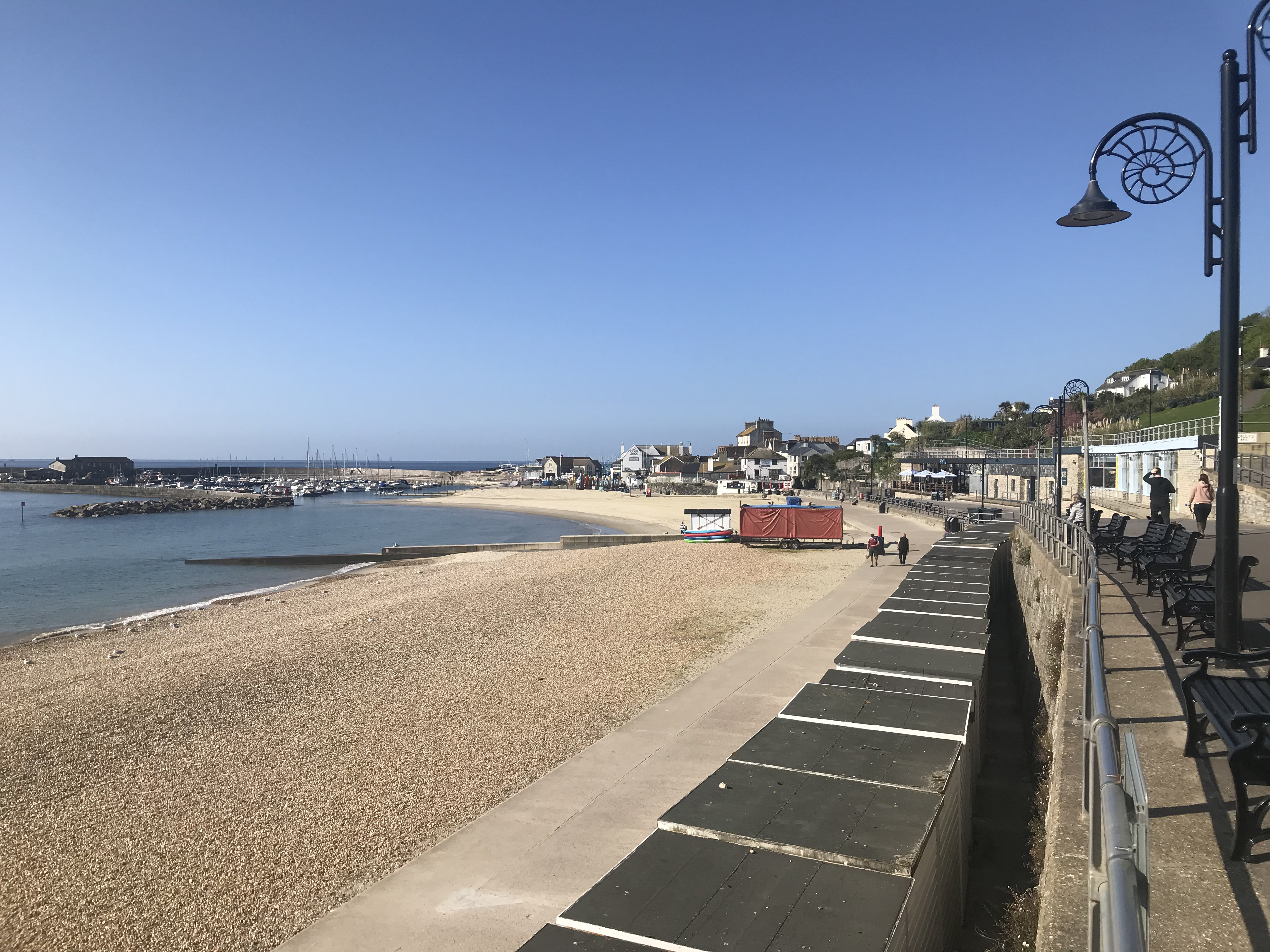
The eastern shore of Lyme Regis exposes Early Jurassic limestone and shale at Church Cliffs, East Cliff and Broad Ledge. Ammonites, belemnites and shells are the familiar fossils, while named limestone ledges and dark mudstones reveal a detailed marine succession with a long history of scientific study.




FIND FREQUENCY: ♦♦♦ – Ammonites, belemnites and shells are more realistic finds than rare vertebrate material.
CHILDREN: ♦♦♦♦ – A guided walk and safe permitted beach area are preferable; keep children away from cliffs, mudflows and ledges.
ACCESS: ♦♦♦♦♦ – Town seafront access is convenient, but steps and uneven natural shore limit accessibility.
TYPE: – Loose beach fossils and observation of limestone ledges and shale.
DIRECTIONS
♦ Use the signed town seafront access to the eastern seawall or Dorset Council’s Charmouth Road car park, DT7 3DR. Follow signed public paths and steps; steps and uneven ledges limit accessibility.
♦ The original harbour approach and seafront views remain useful orientation, but walking from Charmouth is not an unconditional alternative. Tides, mudflows and closures can prevent passage.
♦ Original geological locality reference: 50.72957°N, 2.92715°W. This is not a verified parking or descent point.
DOWNLOAD THE UKF BOOKLET TO FOSSIL HUNTING AT LYME REGIS
FOSSIL HUNTING
The eastern Lyme shore rewards two different kinds of fossil hunting: spotting large fossils in limestone surfaces, and searching naturally loose beach material for smaller specimens. Ammonites, belemnites and bivalves are the realistic starting points. A worn ammonite may show only an arc of ribs or a section through successive chambers; turn a loose stone over and inspect its edges before dismissing it. A complete exposed spiral is much less usual than a fragment or a fossil still partly enclosed in rock.
The large, strongly ribbed ammonites of the upper Blue Lias include Arietites, with examples historically described as Coroniceras bucklandi now referred to as Arietites bucklandi. The eastern-shore field account particularly associates these with Top Tape, Bed 29. Early cementation protected shells in this limestone from flattening, whereas ammonites in neighbouring mudstone can be crushed. Ribbing and the outer edge help distinguish an ammonite from an irregular calcite patch, but a worn section alone rarely justifies a species name. Photograph specimens fixed in the ledges rather than attempting extraction.
Smaller ammonites such as Promicroceras are also recorded on the beach east of town by the Geological Society’s Lyme account. Treat this as an eastern-beach occurrence, not a reason to label every small ammonite as a Church Cliffs Blue Lias fossil: loose material and landslides can mix sources. Search permitted loose shingle and naturally exposed fragment surfaces patiently. Pyritised fossils may have a metallic appearance, while calcite-filled shells can contrast with darker matrix; mineral colour alone does not identify the ammonite or its bed.
The curved, thick lower valve of Gryphaea arcuata, the “devil’s toenail” oyster, is another distinctive local fossil. It is documented in limestone at Church Cliffs and in Third Quick, Bed 31, at Broad Ledge. Other finds include belemnite guards and small crinoid stem pieces. Shells and their fragments are more likely discoveries than fish or marine-reptile remains; the latter may be scientifically important even when incomplete.
Keep matrix with a find and record the location and collection date. The Fish Bed continuation west of town, Black Ven’s insect-bearing flatstones and celebrated reptiles from the wider Lyme district are regional context, not automatic Church Cliffs records. Beginners benefit from a museum-guided walk. Follow the current West Dorset code and local ownership conditions; do not dig cliffs, split reef beds or damage sea defences. Photograph potentially important bone or associated material before disturbing it and contact Charmouth Heritage Coast Centre for advice.
A chronological record of geological research and discoveries associated with Lyme Regis.
1811–1812 – The Anning ichthyosaur discovery
Joseph Anning found the skull and Mary helped recover the associated skeleton that brought Lyme fossils to scientific attention. Museum research considers Church Cliffs the probable source, but the exact findspot and early accounts are uncertain; it should not be presented as a proven bed-level discovery.
1914 – The eastern Blue Lias numbered
Lang documented the upper Blue Lias at Church Cliffs and related exposures. The bed numbers allow later scientists and coastal engineers to compare the same limestone and mudstone horizons.
1995 – The formation boundary clarified
Hesselbo and Jenkyns placed the top of Blue Lias above Bed 49 on lithological grounds, below the traditional Table Ledge boundary. The modern local engineering framework follows this placement.
2008 – A major Spittles failure
A large landslide on 6 May moved Shales-with-Beef toward the shore. It changed local exposure and illustrates the coast’s instability; the event predates the later article describing it.
2009 – The local boundary succession compared
Gallois and Paul documented thinning and eastward discontinuity of Grey Ledge at Church/East Cliff, burrowing in the upper Blue Lias, and an additional upper Fish Bed in the eastern weathered section. Their work clarified lateral variation without transferring The Slabs succession into Lyme.
2011 – Unusual remains recovered from the Spittles
Nigel Larkin noticed fossil-bearing material below the slip, and local collectors subsequently found additional pieces. The find was recorded and donated to Lyme Regis Museum. Its uncertain identity is part of the scientific story, so no unsupported species name is supplied.
2013–2014 – Coastal works recorded fossil-bearing strata
The new seawall footings exposed short-lived sections that were geologically logged. Paddy Howe examined spoil and recovered around 150 specimens for scientific assessment, including fish and marine-reptile material. These were controlled construction exposures, not present-day collecting sites.
2023 – Collecting code revised
The revised West Dorset code retained the importance of permission, responsible collecting and recording scientifically significant finds. It applies through specified ownership arrangements, not as unrestricted permission across the whole coast.
GEOLOGY
The core eastern-town section exposes the upper Blue Lias Formation and the lower Charmouth Mudstone Formation of the Lias Group. Pale limestone bands alternate with darker mudstone and shale, recording changing marine sedimentation and subsequent carbonate cementation. The resistant limestones project as ledges while the softer layers wear back. This also helps explain the fossils: early-hardened carbonate could support an ammonite shell during burial, while shells in less-cemented mud were more readily flattened. The full Lyme-area Blue Lias is approximately 26–28 m thick, but this shore does not expose its entire lower western succession.
Lang’s numbered beds provide a way to distinguish similar-looking ledges and compare the cliff with the foreshore. In the modern local framework the Blue Lias ends at the top of Grey Ledge, Bed 49. Table Ledge, Bed 53, lies above this boundary within the Shales-with-Beef Member of the Charmouth Mudstone Formation; its use as the top of the Blue Lias belongs to older classifications. Best Bed 41 and Second Bed 39 are separate horizons, and their intervening mudstones are part of the record rather than gaps to omit.
The Shales-with-Beef contains dark marine mudstone cut by conspicuous fibrous calcite seams. “Beef” describes this mineral growth, not fossil tissue. Limestone markers continue within the muddier succession, so a hard ledge alone does not identify the formation. Gentle folding and faults repeat or offset beds across Broad Ledge, while landslides can mix rock from higher levels into beach material. Follow the numbered succession below when comparing exposures; a loose fossil’s position on the beach cannot establish its original horizon.

The detailed geological succession and important exposure limits at Lyme Regis.
The eastern town coast exposes the upper Blue Lias and basal Charmouth Mudstone, with faults, folds and landslides interrupting the apparent succession. The named markers below are source-supported; lower western beds and a full Charmouth log have not been imported. The historical graphic is a synthesis with approximate scale and lateral variation; this qualification applies to all entries attributed to that graphic below. Explicit thickness limits, uncertain correlations and historical fossil identifications remain stated beside the affected beds.
LIAS GROUP
Early Jurassic marine strata underpin the eastern Lyme shore. The core section here is Church Cliffs, East Cliff and Broad Ledge, with the western Spittles landslide as nearby context.
Blue Lias Formation
Alternating limestone and mudstone reflect changing sediment conditions and subsequent early carbonate cementation. The full Lyme-area formation is about 26–28 m, but the eastern shore exposes its upper half, Lang Beds 1–49. The upper boundary is above Bed 49, not Table Ledge. No lower western H-bed log is transferred here.
Age: Upper local part: late Hettangian–early Sinemurian
Brick Ledge — Bed 1
The lowest named limestone in the upper eastern sequence is Brick Ledge. Beds 1–2 have rarely been exposed in recent observations; the bed’s presence in a log does not guarantee access at beach level.
Soft Bed / Pig’s Dirt — Bed 3
The historical graphic names this horizon and notes Plagiostoma. No measured thickness is supplied.
Lower Venty — Bed 5
Named in the graphic log; no separate lithological description or measured thickness is supplied.
Lower Skulls — Bed 7
The graphic describes a wavy limestone above Brick Ledge, with large Plagiostoma on its upper surface. Its approximate vertical position is not a measured bed thickness.
Under White Bed — Bed 9
Named limestone marker in the historical graphic; no separate measured thickness is given.
Under Copper — Bed 11
The historical log notes an irregular upper surface and records Plagiostoma and Calcirhynchia.
Iron Ledge — Bed 13
A named limestone marker within the upper Blue Lias. Geological mapping beneath the older wall traced this horizon near its north-eastern end.
Upper Skulls — Bed 15
Two limestone layers can merge laterally into a single nodular limestone; historical ammonite records include Schlotheimia.
Third Tape / Upper White Bed — Bed 17
The graphic identifies Thalassinoides burrows. No separate measured thickness is given.
Specketty — Bed 19
A strong, regular limestone with a relatively flat top is shown in the historical synthesis; its fossil labels include Calcirhynchia and Plagiostoma.
Second / Lower Mongrel — Bed 21
The alternative names refer to the same numbered horizon. The graphic notes lignite and historical Liogryphaea obliquata and Arietites records.
Mongrel Shales — Bed 22
This mudstone interval contains recorded crinoid material, with a published occurrence in sub-bed 22d. This historical attribution is specific to sub-bed 22d rather than every shale between the limestones.
Mongrel — Bed 23
The named limestone is an important field marker in the eastern anticlines. Broad Ledge mapping includes Bed 23 and higher beds, repeated or offset by small faults.
Top Copper — Bed 25
Historical quarrying at the foot of Church Cliffs used this limestone. Its old economic name should not be interpreted as evidence for copper ore.
Second Tape — Bed 27
Named in the historical graphic between Top Copper and Top Tape; no separate lithological detail is inferred.
Top Tape — Bed 29
The local field guide records large three-dimensional ammonites and Thalassinoides in this limestone, contrasting with flattened ammonites in adjacent mudstone. The identification of one photographed crinoid-rich surface as Top Tape is only tentative.
Third Quick Shales — Bed 30
Mudstone bordering the Third Quick limestone has historical bivalve, ammonite and crinoid records; sub-bed 30a is specifically cited for crinoid ossicles. Do not confuse loose shales with the harder ledge above.
Third Quick — Bed 31
A persistent muddy limestone about 0.3 m thick forms much of mapped Broad Ledge. Fossil oysters include Gryphaea arcuata. Its surface may be obscured by modern marine growth or submerged; no bedrock extraction is proposed.
Gumption Shales — Bed 32
The mudstone package includes laterally variable limestone development and recorded crinoids in sub-bed 32g. Engineering work showed why these variable beds were less reliable foundations than the more persistent limestones.
Gumption — Bed 33
A thin, persistent limestone in the historical graphic, with fish remains reported. No thickness is measured from the approximate diagram scale.
Second Quick — Bed 35
The graphic names this limestone and lists Pentacrinus. The nearby small Gumption ledge helps distinguish it from Third Quick.
Rattle Shales — Bed 36
The shale interval below Rattle is named in the graphic; historical fossils include Arietites and Arnioceratoides.
Rattle — Bed 37
An irregular, laterally impersistent limestone in the historical graphic.
Second Bed Shales — Bed 38
The graphic names the shale interval and records historical Nautilus and Ostrea irregularis. These names are retained as historical determinations.
Second Bed — Bed 39
The graphic and modern primary framework distinguish Second Bed 39 from Best Bed 41. The graphic records crinoids and brachiopods and places an old plant occurrence near this level, not at a precisely verified sub-bed.
Best Bed — Bed 41
Both the West graphic and the modern primary framework identify Bed 41 as Best Bed. West’s isolated prose calling it Second Bed is an inconsistency, not an equally supported alternative.
Venty Shales — Bed 42
Alternating marl and bituminous shale are described in the historical graphic. Historical ammonite and marine-reptile labels are not proof of an exact modern specimen identification.
Venty — Bed 43
A named limestone with historical fish-spine records. The 2009 Church Cliffs description documents burrowing through beds 43–49.
Top Quick Shales — Bed 44
The intervening shale horizon is named in the graphic; no separate measured thickness is supplied.
Top Quick — Bed 45
A named limestone marker, with historical Arietites bucklandi, Plagiostoma and saurian-bone records in the synthesis.
Glass Bottle Shales — Bed 46
The graphic names this shale interval and correlates it with Wright’s W6 horizon; no unsupported thickness is inferred.
Glass Bottle — Bed 47
A strong limestone with large ammonites on its underside. Where Grey Ledge is missing it can appear to be the highest strong limestone. The primary Church/East Cliff study records Arenicolites in this bed.
Grey Ledge Shales — Bed 48
The graphic names the mudstone interval immediately beneath Grey Ledge; no separate measured thickness is given.
Grey Ledge — Bed 49
This is the highest limestone within the modern Blue Lias boundary used in the local engineering study. Above it begins the Charmouth Mudstone succession. Gallois and Paul (2009) measured 0.1–0.2 m at Church/East Cliff and found it becoming discontinuous eastward, locally lenticular and possibly filling scours. Beds 43–49 include Planolites, Chondrites and Arenicolites burrows.
Charmouth Mudstone Formation
The lower part succeeds Grey Ledge at eastern Lyme. The full regional formation continues toward Charmouth, but its complete measured log belongs to that separate locality.
Shales-with-Beef Member
Organic-rich and calcareous mudstone contains conspicuous fibrous calcite seams. “Beef” describes mineral veins, not fossil tissue. East Cliff exposes up to about 10 m of the lower member, Lang Beds 50–55, above the Blue Lias. Higher beds occur inland and in disturbed landslides.
Age: Sinemurian
Fish Bed Shales — Bed 50
Shale beneath Fish Bed has historical fish remains near its top. West’s prose gives 0.76 m; this is an attributed historical measurement, not a uniform thickness along the shore.
Fish Bed — Bed 51
The marker is shown above the modern Blue Lias boundary in Gallois’ local framework. Fish remains are scientifically important but complete fish are exceptional, not routine family finds.
Saurian Shales — Bed 52
The historical graphic describes shale containing fibrous calcite “beef”, with fish, ammonite and marine-reptile records. West’s prose gives 2.92 m; lateral variation and old specimen identifications remain relevant.
Additional upper Fish Bed
Gallois and Paul document an additional upper Fish Bed between Fish Bed and Table Ledge in the deeply weathered eastern East Cliff section. No Lang number, precise thickness or The Slabs bed equivalent is assigned.
Table Ledge — Bed 53
Table Ledge lies within Shales-with-Beef under the modern boundary placement. Older guides used it as the top of the Blue Lias; that historical convention should be explained rather than repeated as current classification. West’s local prose gives a historical thickness of 0.30 m; this does not imply constancy along the coast.
Higher Shales-with-Beef markers
Devonshire Head Limestone (Bed 72), Spittles Limestone (Bed 74) and Birchi Tabular (Bed 76) appear in the regional local framework. These help interpret nearby Spittles material, but are not a claim that all three can be followed in a safe continuous Church Cliffs exposure.
Spittles landslide material and younger cover
Slides can mix Jurassic mudstone with younger weathered sediment and material derived from the Upper Greensand. The 2008 failure chiefly involved Shales-with-Beef. A fossil’s beach position alone does not prove its original bed.
Black Ven Marl and Belemnite Marl: subsurface limit
Phase IV boreholes proved higher Charmouth Mudstone units inland, but these are not a complete open Church Cliffs section. The detailed Black Ven and Charmouth succession is therefore excluded from this guide’s measured inventory.
References
Council Lyme Parking
Deposits Bones
Deposits Spittles
Lyme Gallois 2016
Lyme Museum First Ichthyosaur
Lyme Museum Mary
Review Lyme Gallois 2009
Review Lyme West Log
West Code 2023
West Lyme East
SAFETY
Consult tides, weather and local advice before entering the shore. Keep clear of cliff bases, mudflows and new falls, and leave ample time to return without crossing submerged ledges. Never climb the Spittles or use ropes to reach fossil beds. Guided museum walks are a better first introduction than attempting a long independent coastal traverse.
EQUIPMENT
Wear sturdy footwear for uneven ledges and carry tide information, a phone, notebook, wrapping and small protective boxes. A hand lens helps with small shells and fragments. A guided walk is a useful first visit; do not take tools as a reason to split reef beds or uncertain material.
CLEANING AND TREATING
Keep fragile fossils and their matrix together, support matching fragments and retain exact collection notes. Pyritised material needs dry, stable storage and monitoring for deterioration; blanket soaking or sealing is inappropriate. Seek specialist advice for unusual bone, fish or a fossil that begins to powder.
IDENTIFY YOUR FINDS
Need help identifying a fossil? Share clear photos, where you found it and its size with the community.
FURTHER READING
The Spittles landslip, Lyme Regis
Baffling bones from Lyme Regis
Gallois 2016: geology and coastal engineering at eastern Lyme
Lyme Regis to Charmouth field guide: use exact eastern Lyme passages
Museum account of the first ichthyosaur and uncertain findspot
West Dorset Fossil Collecting Code 2023
Dorset Council Charmouth Road parking
Gallois and Paul 2009: local boundary variation
ACCESS RIGHTS
Follow the current West Dorset Fossil Collecting Code and the relevant owner’s conditions. Beginners should look only for loose fossils in permitted safe beach areas, without digging, hammering reefs or damaging sea defences. Important finds should be recorded through Charmouth Heritage Coast Centre; cliff excavation requires permission and specialist arrangements. The code itself identifies ownership limits, so check the exact shore sector rather than assuming all Lyme land is covered.
Protected-site information: SSSI Information – West Dorset.
It is important to follow our ‘Code of Conduct’ when collecting fossils or visiting any site. Please also read our ‘Terms and Conditions’.
LINKS
♦ Fossil Discussions
♦ Fossil Articles
♦ Buy Fossils, Tools and Equipment
♦ Buy Crystals, Meteorites, and Artefacts
♦ Join Fossil Hunts
♦ UK Fossils Network


