

Overview
Directions
- Follow the A855 north from Portree towards Staffin. Rigg is around ten miles from Portree, where the road runs above the abandoned coastal settlement.
- The approach described here starts opposite a house on the inland side of a bend, overlooking a small valley. Use roadside space only where parking is lawful and safe; keep the track entrance, gates and passing places clear.
- Follow the valley downhill past the old settlement towards the coast, using gates or other suitable crossing points without damaging fences. Turn north across the coastal ground towards the wooded burn and the old salmon-station bothy. The route uses higher sheep tracks before descending near the bothy to the boulder shore; these are rough, exposed paths rather than a maintained visitor trail. Check the route on the ground and turn back if the burn or descent cannot be crossed safely.
- Published locality reference: NG 52070 56925. This is an orientation point, not a surveyed parking space or a guaranteed safe shoreline access point. Plan the visit around a falling tide, calm conditions and enough daylight to return by the same route.
Location photographs
Swipe to browse · Select a photograph to enlarge


Fossil Hunting
Ammonite moulds and belemnites are the main fossils to recognise on the Rigg shoreline. Look for coiled outlines and ribs on naturally weathered sandstone surfaces. An ammonite may survive as shell material, an impression where the shell has disappeared, or a solid internal mould: sediment that filled the shell and retained its shape. A large spiral exposed across a block does not necessarily represent a complete specimen, and its centre may be missing or obscured.
The ribbed ammonite Stephanoceras is recorded from the Rigg Sandstone succession on this coast. Species identification needs more than size and an outline: weathering, flattening and incomplete preservation can conceal important features. Keep a photograph-based identification at genus or broader level when the necessary details are absent, rather than assigning every large specimen to Stephanoceras humphriesianum.
Belemnites are remains of squid-like animals. Their robust, commonly pointed guards are easier to recognise than the more fragile chambered phragmocone. Guards can appear as elongated shapes along a rock surface or rounded sections where broken across; they are not teeth. The large Rigg specimen displayed at Staffin Museum includes the phragmocone, which is why its reported overall length must not be treated as the length of a guard.
Oysters and other bivalves occur in shell-bearing sandstone, and the existing site record also notes wood and crinoid fragments. Wood was transported from land into the marine setting, so it does not by itself identify a freshwater bed. Rounded concretions, often called doggers, are rock bodies rather than fossils in their own right. The circular worked stone in the gallery is a quernstone, an archaeological object; leave it and other archaeological material undisturbed.
Study safely accessible weathered surfaces and photograph finds with a scale. Record whether a fossil is in bedrock or in a loose block, together with its location and surrounding rock. Detached material has lost its original bed relationship and cannot establish the age of adjacent ledges. Leave suspected vertebrate remains in place and seek specialist advice.
Fossil photographs
Swipe to browse · Select a photograph to enlarge


Discoveries and milestones
A chronological record of documented geological work and a notable fossil find at Rigg.
1966 – Rigg Burn succession documented
A detailed geological account recorded the sandstone and shale succession in Rigg Burn, including individual beds and the overlying dolerite sill. Separate observations in its southern tributary showed thin sill leaves splitting and rejoining among fossiliferous shales and limestones.
1985 – Large belemnite collected at Rigg
Dugald Ross collected a large belemnite at Rigg that subsequently became a Staffin Museum exhibit. It was described as Megateuthis giganteus and approximately 80 cm long including its chambered phragmocone. This is a record of an individual specimen, not a typical size for finds on the shore.
Geology
Rigg’s fossil-bearing shore belongs to the marine Bearreraig Sandstone succession, with the Bajocian Rigg Sandstone Member representing part of the Middle Jurassic record. Calcareous sandstone is prominent: sand grains are cemented by calcium carbonate, and some layers approach sandy limestone. Muddier sandstone and subordinate mudstone provide softer intervals between the resistant beds. This contrast helps explain the ledged appearance of the shore and the recesses visible in the cliffs.
Ammonites and belemnites record marine animals, while shell-rich layers preserve bottom-dwelling molluscs. Plant fragments were carried into the sea from land. The sandstone therefore records a marine environment receiving sediment and organic debris from nearby land, rather than a separate freshwater deposit wherever wood is present. On this coast the younger parts of the succession come down towards sea level northwards, but cliffs, fallen blocks and changing exposure make bed-by-bed tracing difficult.
The formation name covers a much wider age range and succession elsewhere on Skye. At Rigg it is misleading to use that entire regional history as the age of every visible ledge. Likewise, the older list of Witchellia, Sauzei and Concavum zones cannot be treated as several established subzones at the precise collecting beach. The useful local distinction is between the Bajocian marine sandstone record and the younger lagoonal and deltaic rocks documented inland.
In Rigg Burn the older survey recorded a detailed sandstone–shale section using the names “White Sandstone” and “Estheria” Shales. Modern terminology relates these to the Elgol Sandstone and Lealt Shale formations of the Great Estuarine Group. However, the old and modern published thicknesses at Rigg differ substantially, so their individual beds cannot be equated automatically. The full historical log is retained separately in the expanded account, with its original scope and the unresolved correlation made clear.
Dolerite intrusions cut into the younger sedimentary succession. The burn observations include thin sill leaves that divide and rejoin, an important warning against reading every dark band as another sedimentary layer. Finally, modern erosion and rockfalls mix material on the shore: a loose fossil-bearing boulder may come from a higher bed than the rock platform on which it rests.
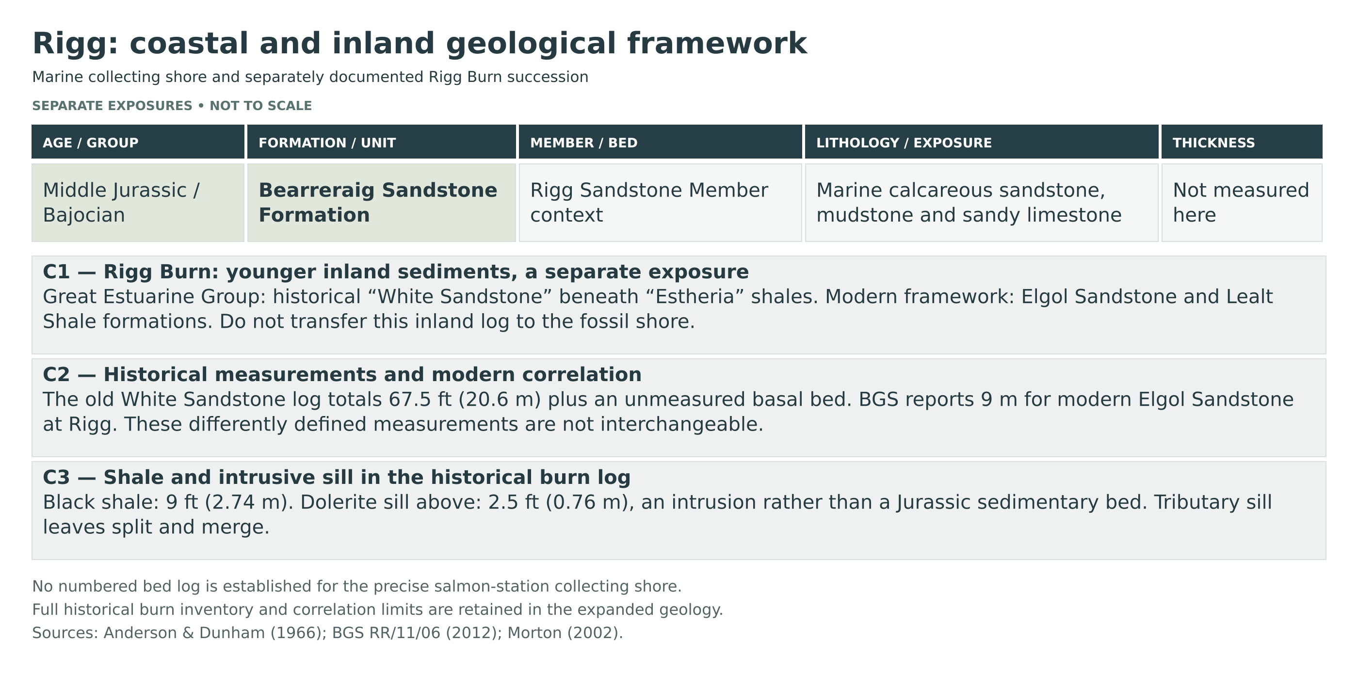
Detailed geology and bed-by-bed succession
Marine shoreline geology and the separately documented historical succession in Rigg Burn.
The collecting shore, the historical Rigg Burn section inland and the better-known Bearreraig Bay section are different exposures. The account below distinguishes them. It does not imply that the burn log is accessible today, or that every unit can be followed continuously to the beach.
Bearreraig Sandstone Formation
This formation has no formal parent group in the modern BGS framework. It represents marine sand, silt and mud deposition. The formation’s regional age range extends older than the Rigg member, and its total regional thickness is not a measurement of this beach.
Rigg Sandstone Member
In the established Trotternish succession this member contains alternating softer muddy sandstone and harder calcareous sandstone or sandy limestone. Large ammonites, belemnites, bivalves and transported wood occur in the member. The detailed bed thicknesses published for Bearreraig Bay are not measurements of the Rigg collecting shore.
Shoreline horizons and limits of correlation
The historical survey recorded brownish sandstone with large oysters, belemnites and a nautiloid approximately half a mile south of Rigg. The nautiloid was recorded as 19 inches across, about 48 cm. These fossils were observed in place, around or slightly above the ammonite-bearing level. This is a geographically specified southern record, not a fossil bed relocated to the salmon-station beach. The accessible sources do not provide a numbered, bed-by-bed log tied to the precise shore reached by this guide. Accordingly, no borrowed bed numbers, member thicknesses or lower Aalenian biozones are assigned to that shore.
GREAT ESTUARINE GROUP
Younger Jurassic strata were logged inland in Rigg Burn. These belong to the broader change from marine conditions to lagoonal and deltaic environments. The 1966 account used the names “White Sandstone” and “Estheria” Shales. The modern equivalents are the Elgol Sandstone and Lealt Shale formations, respectively, but the old logged intervals cannot all be correlated bed-for-bed merely by replacing the headings.
Elgol Sandstone Formation
The modern BGS framework reports 9 m at Rigg. In contrast, the 1966 Rigg Burn “White Sandstone” log contains 67.5 ft, approximately 20.6 m, of measured beds plus an unmeasured basal interval, and describes this as the upper part of the old unit. These are different published measurements or delimitations, not interchangeable thicknesses. The historical sequence is therefore retained under its original scope without forcing each bed into the modern 9 m formation.
Rigg Burn: historical “White Sandstone” log, bottom to top
The labels RB1–RB13 below are editorial identifiers, not published bed numbers. Metric values are rounded conversions of the original feet. No species or depositional interpretation is assigned to an individual bed unless the source supports it.
RB1 — Shaly sandstone with hard bands (thickness not recorded)
Basal entry; its thickness was not stated.
RB2 — Waterfall-forming sandstone (2 ft; approximately 0.61 m)
A resistant sandstone bed above the basal shaly interval.
RB3 — Black sandy calcareous shales (20 ft; approximately 6.10 m)
The thickest measured muddy interval in this historical log.
RB4 — Irregular ferruginous calcareous sandstone (2.5 ft; approximately 0.76 m)
An uneven, iron-stained sandstone above the black shales.
RB5 — Dark sandy calcareous shales (5 ft; approximately 1.52 m)
The lower of two similar shale intervals separated by thin hard sandstone.
RB6 — Hard ferruginous sandstone (1.5 ft; approximately 0.46 m)
The lower of two thin, resistant ferruginous sandstone beds.
RB7 — Dark sandy calcareous shale (5 ft; approximately 1.52 m)
A second muddy interval between the thin hard sandstones.
RB8 — Hard ferruginous sandstone (1.5 ft; approximately 0.46 m)
The upper thin ferruginous sandstone bed.
RB9 — Sandstone with doggers (10 ft; approximately 3.05 m)
Sandstone containing concretions; the source does not assign fossils to these doggers.
RB10 — Shaly sandstone (10 ft; approximately 3.05 m)
A shaly sandstone interval above the concretion-bearing sandstone.
RB11 — Soft sandstone (10 ft; approximately 3.05 m)
The highest sandstone entry, beneath the black shale.
Lealt Shale Formation
RB12 — Black shale: historical ‘Estheria’ Shales (9 ft; approximately 2.74 m)
The overlying shale belongs to the succession now termed Lealt Shale Formation; no bed-specific fauna was listed.
Southern tributary of Rigg Burn
A separate nearby exposure was recorded with about 3 ft (0.91 m) of shale below a 2 ft (0.61 m) sill, 1 ft 3 in (0.38 m) of shale and an upper sill 1 ft 9 in (0.53 m) thick. The two sill leaves merged approximately 20 yards farther north. Above the waterfall, intermittent black-shale exposures included thin limestones, some rich in Neomiodon, and fibrous calcite traditionally called “beef”. This is a separate observation, not additional beds appended to the main burn log.
Younger igneous intrusion: RB13 — dolerite sill (2.5 ft; approximately 0.76 m)
The top entry of the main burn log is a sill. Its position in the log records where magma intruded, not a further episode of Jurassic sedimentation. The tributary observations show that sill leaves can split and merge, complicating apparently simple layer-by-layer comparisons.
References
Lee, G. W. (1920), The Mesozoic Rocks of Applecross, Raasay and North-East Skye, pp. 50–51.
Anderson, F. W. and Dunham, K. C. (1966), The Geology of Northern Skye, Chapter 3.
Barron, A. J. M., Lott, G. K. and Riding, J. B. (2012), Stratigraphical framework for the Middle Jurassic strata of Great Britain, BGS RR/11/06.
Morton, N. (2002), Bearreraig Bay, in British Middle Jurassic Stratigraphy; used for regional member context, not as a Rigg beach log.
Safety
Rigg is a strenuous coastal outing for experienced walkers. Boggy slopes, exposed informal paths, stream crossings and an uneven boulder shore make it unsuitable for young children or anyone uncomfortable with difficult ground. Visit with a companion, carry a map and suitable footwear, and leave your route and expected return time with someone.
Check the tide times, wind and swell before setting out. Use the lower shore only when conditions allow a safe return; low tide alone does not make it safe. Wet rock, seaweed and loose blocks are slippery, while cliffs and overhangs can shed rock without warning. Keep clear of cliff bases, edges and fresh falls.
Turn back before gullies, burns or rising water block the route. Do not rely on informal side paths or the crossing nicknamed “Tarzan Waterfall” as escape routes, and never improvise a climb up the cliffs. Carry waterproofs, food, water, a first-aid kit and a charged phone, but do not rely on mobile reception beneath the cliffs. In a coastal emergency, call 999 or 112 and ask for the Coastguard.
Equipment
Wear sturdy walking boots with good grip and carry waterproofs, food, drinking water, a map and a means of checking tides. A hand lens, camera and small photographic scale are the most useful tools for examining shells and ammonites. Carry a charged phone, but do not rely on continuous reception along the cliffs.
Do not burden yourself with heavy tools or large blocks on this long, tiring route. Observation and photography are the appropriate starting point where collecting permission has not been established. If permission is granted for particular loose material, use only the methods and quantities agreed with the landowner; never work beneath unstable cliffs.
Cleaning And Treating
For specimens already lawfully collected, keep fragile shells and ammonites supported in their matrix. Begin with gentle dry brushing and examine the fossil under a hand lens before attempting to remove rock. The hard calcareous blocks may fracture through the fossil rather than around it, while shale can split or crumble unexpectedly.
Do not soak unknown shale specimens or use acids, bleach or varnish as a routine treatment. Avoid heat when drying damp material. Keep labels with the exact locality and, where known, the bed or rock type: the mixed shoreline material represents more than one geological age. Ask an experienced preparator before attempting work on a delicate or unusual fossil.
Identify Your Finds
Need help identifying a fossil? Share clear photos, where you found it and its size with the community.
Further Reading
Geology museums of Britain: Staffin (Dinosaur) Museum, Isle of Skye — an illustrated museum visit including the large belemnite found at Rigg in 1985.
The Geology of Northern Skye: Great Estuarine Series — the historical Rigg Burn log and neighbouring observations, using older geological names.
BGS Middle Jurassic stratigraphical framework — modern formation names and their relationship to historical terminology.
Access Rights
The Rigg locality described here, reached past the abandoned settlement towards the old salmon station, lies north of the mapped boundary of Rigg–Bile Site of Special Scientific Interest. The published locality reference and this northern shore are also outside the mapped Skye Nature Conservation Order area at Bearreraig. The protected coast farther south is a separate area with additional restrictions. Check the official boundaries before extending a visit.
Being outside those boundaries does not give permission to take fossils. Responsible walking access and permission to remove geological specimens are separate matters. Obtain the landowner or occupier’s permission, and the mineral owner’s permission where different, before collecting. No general collecting permission is established by this guide. Follow the Scottish Fossil Code; where permission is absent or uncertain, leave specimens in place and photograph them.
Do not excavate cliffs, hammer bedrock, damage fossil surfaces or disturb the settlement remains, walls or other archaeology. Record unusual fossils with photographs and their position, and seek expert advice before attempting removal. Suspected vertebrate bones or footprints should be left in place and reported to NatureScot or an appropriate museum. Within the separate Skye Nature Conservation Order areas, vertebrate fossils have additional legal protection, including loose fragments; collecting in an SSSI must also follow its consent requirements.
It is important to follow our Code of Conduct when collecting fossils or visiting any site. Please also read our Terms and Conditions.
Links
♦ Fossil Discussions
♦ Fossil Articles
♦ Buy Fossils, Tools and Equipment
♦ Buy Crystals, Meteorites, and Artefacts
♦ Join Fossil Hunts
♦ UK Fossils Network


