
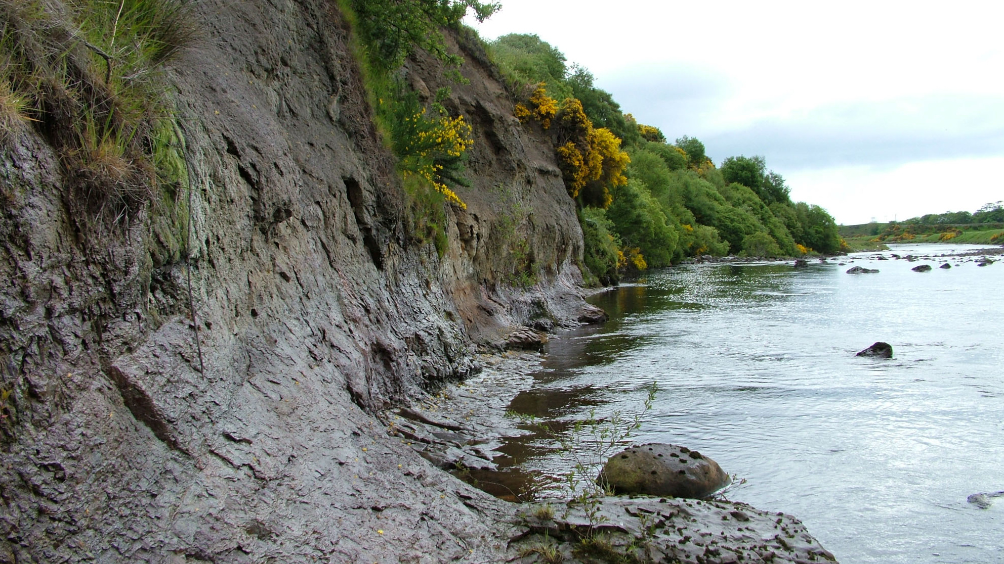
Overview
Directions
- From the north side of the A9 bridge in Brora, take the road west towards Gordonbush and Rogart. The recreation-ground car park is the starting point shown in Highland Council’s walking leaflet. Follow current signs and parking arrangements; the former farm-track parking advice is not relied on.
- Use the established paths and tracks towards Bruachrobie and Doll Bridge. Keep to safe paths for views of the river section; do not descend the historical cliff-top gate route or enter the river to reach the rocks. Respect gates, livestock, angling activity and temporary closures.
- Geological reference: 58.01116°N, 3.87982°W. The published Bruachrobie section is at grid reference NC 888 040. These identify the geological locality, not a parking place or a safe descent point.
Location photographs
Swipe to browse · Select a photograph to enlarge


Fossil Hunting
Belemnites are the most characteristic fossils of the Bruachrobie section. Their solid, elongated guards contrast with the much flatter preservation of ammonites in the muddy rocks. The measured section records Cylindroteuthis puzosiana, particularly in the Glauconitic Sandstone Member, where guards occur with wood fragments and rows of phosphatic nodules. The historical photographs also show ammonite impressions, but their species cannot be established from these images alone.
The fossil-bearing sandstone bands tell a different story from the dark shale between them. In the upper Brora Shale Member, sandy horizons contain plant fragments, belemnites and shallow-marine bivalves carried into a quieter, poorly oxygenated setting. In the lower Glauconitic Sandstone Member, repeated sandy bands concentrate belemnite guards and scattered pieces of wood. Recognising these alternating rock types in photographs or distant views is more useful than treating every ledge as equally fossiliferous.
The middle, silty division of the Glauconitic Sandstone has a sparse fauna, including the bivalve Meleagrinella braamburiensis and the brachiopod Lingula craniae. The basal Brora Brick Clay records Cylindroteuthis puzosiana and the bivalve Solemya woodwardiana. These are documented occurrences within the measured succession, rather than a promise that each can be recognised on a casual visit. Ammonite impressions can be fragile and incomplete; preservation and horizon are essential to an identification.
Burrows are another important part of the fossil record. Branching networks and other disturbed bedding surfaces record animals living in the sediment during better-oxygenated intervals. The section includes Thalassinoides, Diplocraterion and Chondrites; the measured log also records Planolites and Teichichnus. These trace fossils reveal changes in seabed conditions even where recognisable shells are scarce.
Phosphatic nodules should not automatically be mistaken for complete fossils. Some contain microscopic sponge spicules of Rhaxella, identified in thin section, rather than visible whole sponges. Nor does a nodule guarantee an uncrushed ammonite. For a useful observation record, photograph the overall bedding and then any naturally visible detail with a scale where this can be done safely, noting whether the material is sandstone, shale or a nodule. Use zoom or binoculars where the exposures cannot be approached safely.
This is an observation guide: collecting permission and any required protected-site consent have not been confirmed. Do not remove material, split nodules or work the exposures. The photographs record earlier visits and do not endorse the water-edge or cliff-foot access shown in some views. The access and safety sections below explain the present precautions.
Discoveries and milestones
A chronological record of significant stratigraphic research at Bruachrobie and the separately identified downstream River Brora sections.
1975 – River reference sections formalised
R. M. Sykes defined the local Callovian–Oxfordian succession, including the north-bank Glauconitic Sandstone and basal Brora Brick Clay reference exposures at Bruachrobie. Downstream river sections also supplied sandstone stratotypes, establishing the scientific importance of distinct stretches of the river.
1980 – Downstream ammonite reference sections proposed
J. H. Callomon and R. M. Sykes proposed River Brora sections as reference sections for the Henrici and Lamberti subzones. These were historical proposals concerning the younger downstream succession, not discoveries at the Bruachrobie cliff or a claim of present global stratotype status.
1993 – Bruachrobie measured section documented
The excursion guide edited by N. H. Trewin and A. Hurst documented the north-bank section, including the three divisions of the Glauconitic Sandstone, repeated sandy units and the basal Brora Brick Clay. This measured framework underpins interpretation of the river exposure.
2002 – Conservation review assesses the river sections
K. N. Page’s Callovian site account assessed the combined coastal and river succession, distinguishing the Bruachrobie lithostratigraphic type sections from the younger river reference sections downstream. This was a scientific conservation review, not the date of SSSI designation.
2009 – Updated guide records surviving exposures
The revised excursion guide described the surviving river sections and recorded that landscaping had already removed former brick-pit exposures around Fascally. It also documented the restricted extent of the Brora Brick Clay exposed at Bruachrobie; the loss of the pits was not dated to 2009.
2012 – Modern formation boundaries clarified
A revised British stratigraphic framework assigned the three Bruachrobie members to the Strathsteven Mudstone Formation and placed the Fascally Siltstone in the Clynekirkton Sandstone Formation. This separates the muddy Bruachrobie succession from the younger sandstone-dominated framework.
2014 – Onshore succession formally revised
A. J. M. Barron and J. B. Riding revised the Moray Firth onshore lithostratigraphy and the Sutherland Group. Their work retained the three Bruachrobie members within Strathsteven Mudstone and clarified why offshore correlations must not be used as onshore group names.
Geology
The Bruachrobie cliffs expose part of a Middle Jurassic, Callovian marine succession. In the modern scheme, the rocks belong to the Strathsteven Mudstone Formation of the Sutherland Group. The upper Brora Shale Member passes into the Glauconitic Sandstone Member and then the lower Brora Brick Clay Member. This is not a section chiefly through the Brora Coal Formation, and the offshore Fladen Group is not the appropriate group name for these onshore beds.
Dark, organic-rich muddy sediment accumulated when circulation and oxygen supply at the seabed were poor. At intervals, sand and shallow-water material were carried farther offshore, probably during episodes of stronger sediment delivery and storms. Glauconite grains, phosphatic nodules, plant fragments and belemnite guards help distinguish these sandy events. Burrowing organisms colonised the seabed during more oxygenated intervals, leaving a marked contrast between disturbed sandstones and less-burrowed shale.
The Glauconitic Sandstone contains a lower set of repeated sandy cycles, a quieter silty middle division and a cleaner upper sandstone division. The abrupt return to finer sediment at its top marks the Brora Brick Clay. Thin sandy beds within that clay-rich interval record smaller sediment-gravity flows bringing material from shallower water. These variations explain why fossils and traces are concentrated in particular bands rather than evenly distributed through the cliff.
An anticline exposes the upper Brora Shale in its core, about 80 m downstream from the western end of the cliff. On its eastern limb, the overlying sandstone and brick clay descend towards river level. Consequently, cliff height and distance along the bank are not simple measures of geological age. Vegetation and slippage interrupt the exposure, and only the lower part of the Brora Brick Clay is visible here.
Younger rocks at Fascally, Cawcrask and near the road bridge belong to separate downstream sections of the Clynekirkton Sandstone Formation. Their cleaner sandstones, shell moulds and cross-bedding record different parts of the marine succession. They are described separately below to avoid combining the whole River Brora into a single continuous column at Bruachrobie.

Detailed geology and bed-by-bed succession
Detailed geology of Bruachrobie, with separate downstream River Brora context and references.
The account below proceeds upwards through the Bruachrobie succession, then treats the separate downstream sections. Thicknesses distinguish exposed intervals from composite totals assembled from different outcrops. The published log does not give formal bed numbers or individual measurements for every repeated cycle; none are assigned here.
SUTHERLAND GROUP
The modern onshore group contains both formations described below. Correlations with offshore successions do not transfer the offshore Fladen Group name to these exposures.
Strathsteven Mudstone Formation
The formation has a composite thickness of about 55 m, comprising the Brora Shale, Glauconitic Sandstone and Brora Brick Clay members. Only part of this total is exposed at Bruachrobie. The historical Brora Argillaceous Formation also included the Fascally Siltstone, now assigned to Clynekirkton Sandstone, so the two formation names are not exact synonyms.
Brora Shale Member
Uppermost exposed interval: approximately 2 m
The top of the member is recorded in the anticlinal core about 80 m downstream from the western end of the north-bank cliff. Vegetation obscures the lower exposure. Sandy layers contain plant fragments, belemnites and phosphatic nodules, with glauconite and transported shallow-marine bivalves. They are interpreted as sediment-gravity-flow deposits carrying reworked shelf material into a more stagnant, deeper-water setting.
The sandy beds contain Thalassinoides, Diplocraterion and Chondrites, whereas the intervening shales lack this burrowing. This contrast reflects intermittent colonisation during better oxygenation against a poorly oxygenated background. The whole member is about 30 m thick in the composite record, including its basal Roof Bed, but that basal bed and the coastal ammonite fauna must not be transferred to this uppermost river exposure.
Glauconitic Sandstone Member
The three published divisions total approximately 10.1 m (4.15 m + 2 m + 3.9 m = 10.05 m before rounding). They are informal divisions within one formal member. The north-bank cliffs provide the reference exposure; weathering can obscure the fine sedimentary structures.
Basal contact and lower division: approximately 4.15 m
Rapid upward coarsening above the Brora Shale introduces a glauconitic, very fine-grained sandstone about 0.5 m thick. This basal bed is included in the lower division, not an additional unit. Eight small coarsening-upward sandstone–shale sequences are recognised. Muddy, glauconitic sandstone beds are separated by thin shale interbeds and contain centimetre-scale phosphatic nodule horizons, randomly orientated wood fragments and abundant guards of Cylindroteuthis puzosiana.
Some phosphate nodules contain microscopic Rhaxella sponge spicules. Intense bioturbation includes Thalassinoides, Diplocraterion and Chondrites at sandstone–shale boundaries; the measured log also records Planolites and Teichichnus. The glauconite was reworked from its place of formation, probably replacing pellets and small shell fragments before transport. Sand delivery and temporary seabed oxygenation alternated with bituminous muddy deposition that restricted the burrowing fauna.
Middle division: approximately 2 m
Grey siltstone is dark and apparently bituminous at its base, becoming siltier and less bituminous upwards. Fossils are sparse; the recorded fauna includes Meleagrinella braamburiensis and Lingula craniae. This interval represents a pause in the sandy progradation, followed by improving oxygenation as the organic-rich character diminishes upwards.
Upper division: approximately 3.9 m
Five coarsening-upward sandstone beds are recognised. They are cleaner and less glauconitic than those in the lower division, with more burrowing in the shaly interbeds. The uppermost bed is approximately 0.8 m thick. Prominent carbonate concretions, or doggers, occur about 2 m below the top of the member. Reworking and a better-oxygenated sediment source help explain the cleaner sand; these interpretations do not establish individually numbered beds or precise thicknesses for the other four cycles.
Brora Brick Clay Member
Basal contact and laminated interval: 1.7 m
The boundary is an abrupt reduction in grain size above the last Glauconitic Sandstone bed. Laminated, slightly burrowed muddy siltstone forms the basal 1.7 m. The sparse documented fauna includes Cylindroteuthis puzosiana and Solemya woodwardiana.
Overlying exposed rhythms: within the lowest approximately 5 m
Three thin silty, very fine-grained sandstone beds mark the bases of three fining-upward units near the top of the river exposure. They are interpreted as small sediment-gravity-flow deposits carrying glauconite and fauna from nearer-shore environments. Slippage and poor exposure limit the upper part; the riverbank shows only about 5 m of the approximately 15 m composite member.
Whole-member context, not an additional river exposure
The full composite member has five fining-upward rhythms and a row of limestone doggers near its middle. These whole-member features must not all be placed within the lowest 5 m visible at Bruachrobie. The historical brick-pit exposures around Fascally are separate; former working and landscaping do not imply current access to them.
Clynekirkton Sandstone Formation
Separate downstream sections. The following members occur around Fascally, Cawcrask and the road bridge, not in the Bruachrobie log above. The formation contains six members and reaches at least 500 m regionally; neither that total nor all six members is exposed at the guide pin. Ardassie Limestone is coastal and Achrimsdale Sandstone belongs to the wider northern/subsurface framework. They are not added to the river-pin succession.
Fascally Siltstone Member
Top of the member at Fascally
In the composite succession, the formation boundary beneath this member is conformable: bituminous sandy siltstone and mudstone of the Brora Brick Clay give way to coarse siltstone and silty fine-grained sandstone. This boundary is not exposed in the partial Bruachrobie log. The complete composite thickness is 33.5 m, largely based on the coastal type section. Only the upper part is exposed on the north bank near NC 899 040. A conspicuous calcareous-nodule horizon lies approximately 1 m below its top. The change to the overlying Fascally Sandstone is marked by the first intensely burrowed, fine-grained muddy sandstone. This siltstone was included in the old Brora Argillaceous Formation but is now the basal member of Clynekirkton Sandstone.
Fascally Sandstone Member
River type section and composite thickness: 6.5 m
The type section is on the north bank opposite excursion locality 5, near Fascally. Fine- to very fine-grained muddy sandstone is intensely burrowed, with upward-fining rhythms and sandy silt towards the top. Sub-horizontal burrow networks include Thalassinoides, and traces of wave-ripple lamination survive. Belemnites and bivalves, especially Chlamys, occur as iron-oxide-stained moulds after dissolution of the original shells. Ammonites are common in the composite record, but this does not establish equal abundance in every river exposure. Its boundary with the cleaner Clynelish Quarry Sandstone is sharp.
Clynelish Quarry Sandstone Member
The composite thickness is estimated at about 20 m, with uncertainty in thickness and correlation. Despite its name, the type exposures are on the south bank around Cawcrask and Fascally. The sandstone is pale yellow, fine-grained, well sorted and quartz-rich, with much less clay than the underlying Fascally Sandstone. At Cawcrask there is a slight overall coarsening upwards, although individual beds commonly fine upwards. Some beds are cross-bedded, individual sandstone units rarely exceed 1 m, and uneven or discontinuous bedding can make the section look deceptively massive. Shell fragments and finely dispersed plant remains occur; fossil and burrow preservation varies with cementation.
Cawcrask, locality 4: basal contact and mud-draped interval
The lower member boundary is exposed here. Approximately 1 m above the base, a laterally variable interval about 25–30 cm thick contains very fine sandstones and muddy lenses. Mud drapes cover sandstone units, with thin laminae commonly only 1–2 mm thick. Some lenses contain current ripples; erosive sandstone-filled surfaces interrupt the muddy layers. Cross-bedding records transport from WNW/NW, although alignment of the outcrop parallel to the depositional trend makes some structures hard to see. These are real sedimentary horizons rather than formally named beds. The sharp erosive base, mud drapes and current structures support a subtidal, tidally influenced interpretation, without requiring a shoreline immediately beside the deposit.
Fascally, locality 5: finer intervals above river level
A very fine-grained sandstone horizon with muddy laminae lies about 2 m above river level and may correlate with the interval about 1 m above the member base at Cawcrask. The correlation is tentative. Ripples in the fine interval indicate flow from ENE towards WSW, providing evidence for current reversal relative to the main cross-bedded sandstones. Above it, the exposed succession generally fines upwards; mud drapes are more common higher up, and shell debris lower down. Near the top is approximately 0.5 m of very fine-grained, bioturbated sandstone. These two localities describe different views of the same member, not extra beds to add to its composite thickness.
Brora Sandstone Member
Separate section near the road bridge
The excursion records about 5 m exposed near the A9 bridge, whereas the modern composite member estimate is at least 30 m. The described section coarsens upwards from the low terrace towards the cliff. Pebbly quartzose sandstone is predominantly planar cross-bedded, with leached shell debris locally concentrated as lags at foreset bases. Rounded quartz pebbles occur in lags and scattered through medium- to coarse-grained sand. Cross-beds indicate flow from approximately ENE, opposite to that reported for the Clynelish Quarry Sandstone. Unlike the finer intervals at Fascally, muddy horizons are absent from the described bridge section, consistent with a persistently energetic tidal sandbar setting. Its inferred lower Oxfordian age depends on correlation: Sykes did not record ammonites from this member. It must not be merged with the Callovian Bruachrobie cliff. The downstream bridge exposures are also affected by tides; their description is geological context, not a recommended river-edge route.
Structural and correlation limits
Gentle folds affect the downstream sections as well as Bruachrobie. At Cawcrask dips are less than 10° towards approximately ESE at the southern end; Fascally lies on the northern limb of a gentle south-east-plunging anticline, with dips around 15° towards SE considered probable. The bridge section has a very low apparent structural dip, less than 1°, but cross-bedding makes that difficult to measure. Changes in bank height, weathering, vegetation and river level are not stratigraphic boundaries. Older thickness estimates differ markedly, especially for the sandstone succession; composite values above are not a claim of uninterrupted exposure or precise correlation between every bank.
References
Hurst, A., in Trewin, N. H. and Hurst, A. (eds), 2009. Excursion Guide to the Geology of East Sutherland and Caithness, excursion 2, especially localities 4–7 and figures 2.10–2.12.
Page, K. N., 2002. Brora (Callovian), in Cox, B. M. and Sumbler, M. G., British Middle Jurassic Stratigraphy, Geological Conservation Review Series 26, pp. 372–376.
Barron, A. J. M., Lott, G. K. and Riding, J. B., 2012. Stratigraphical framework for the Middle Jurassic strata of Great Britain and the adjoining continental shelf, BGS Research Report RR/11/06, section 7.1.
Barron, A. J. M. and Riding, J. B., 2014. A revision of the Jurassic (Bathonian to Oxfordian) lithostratigraphy of the onshore Moray Firth Basin, north-east Scotland. Proceedings of the Geologists’ Association 125, 74–82.
BGS Lexicon: Strathsteven Mudstone Formation, Brora Shale Member, Brora Brick Clay Member and Clynekirkton Sandstone Formation. Historical Sykes descriptions are discussed here through the accessed excursion, conservation-review and revision accounts.
Safety
The main hazards are fast or rising water, slippery banks, steep drops and unstable cliffs. Rain upstream can change river conditions, and slippage may conceal the edge or undermine a seemingly firm bank. Do not wade, cross the river to reach beds, or stand beneath the cliff. A hard hat does not make a cliff-foot route safe. Turn back if the established path is flooded, unstable or obstructed.
The river-cliff exposures are unsuitable for children. Keep well back from the edge, allow enough time to return and check the weather before setting out. The SEPA Brora at Bruachrobie gauge can provide background information on river conditions, but a displayed level or normal-range reading is not proof that any bank, crossing or exposure is safe.
Equipment
For observation from paths, take sturdy walking footwear with good grip, weatherproof clothing, a camera with zoom or binoculars, and a notebook or phone for recording the section. Carry an appropriate map and enough charge for the return walk. Waders, extraction tools and heavy hammers are not appropriate equipment for this visit.
Cleaning And Treating
For material already held lawfully, preserve fragile ammonite impressions and their supporting matrix. Avoid soaking shale, forcing layers apart or scrubbing delicate surfaces. Begin with gentle dry brushing only if the specimen is stable; support flakes and keep any detached pieces together with the original label. Hard nodules should not be split simply in the hope of revealing an ammonite.
Do not use acids, bleach or routine varnish. If a specimen is crumbling, pyritic or potentially scientifically important, leave it unprepared and seek specialist advice before attempting consolidation. Keep locality and horizon information with the specimen; preparation should not remove the evidence that makes it useful.
Identify Your Finds
Need help identifying a fossil? Share clear photos, where you found it and its size with the community.
Further Reading
East Sutherland excursion guide: Brora coastal and river sections
Geological Conservation Review: Brora (Callovian)
BGS Lexicon: Strathsteven Mudstone Formation
Barron and Riding: modern Moray Firth lithostratigraphic revision
Highland Council: Paths around Brora
Access Rights
The Bruachrobie locality lies within Inverbrora SSSI. Use the established riverside paths for geological observation, respecting signs and temporary restrictions. Public access rights do not confer ownership of fossils or permission to remove them. Landowner agreement and any required NatureScot consent are separate matters; neither has been confirmed for collecting here. Accordingly, do not remove fossils, hammer bedrock or work the exposures. This precaution is not a claim that every loose fossil throughout the SSSI is subject to a blanket statutory collecting ban.

Help safeguard Scotland’s fossil resource by following the Scottish Fossil Code. The Inverbrora SSSI management statement explains the conservation interest of the coastal and inland compartments; coastal ownership information should not be assumed to apply to this riverbank.
It is important to follow our Code of Conduct when visiting any site. Please also read our Terms and Conditions.
Links
♦ Fossil Discussions
♦ Fossil Articles
♦ Buy Fossils, Tools and Equipment
♦ Buy Crystals, Meteorites, and Artefacts
♦ Join Fossil Hunts
♦ UK Fossils Network


