

Saltcom Bay in this guide is South Beach beside West Pier, immediately south of Whitehaven harbour. Historical finds include Carboniferous plant remains in mixed colliery spoil. Beach access was reported prohibited for safety in the 2020 Coastal Strategy, and reopening has not been verified. Do not plan a shore-collecting visit without current confirmation from the landowner or Cumberland Council; remain on open signed routes and respect all barriers.


FIND FREQUENCY: ♦♦♦♦♦ – The original guide rated historical finds highly. This is a record of mixed-spoil fossils, not a recommendation to enter the beach or a guarantee of accessible material.
CHILDREN: ♦ – Unstable spoil cliffs and uncertain shore access make this unsuitable for children’s collecting.
ACCESS: ♦ – The 2020 Coastal Strategy recorded prohibited beach access and closed cliff-top parking. Current reopening has not been verified; do not enter while signs, barriers or restrictions apply.
TYPE: – An artificial colliery-spoil cliff and reworked beach material, above separately mapped natural deposits. The fill is not an intact Carboniferous bed sequence.
DIRECTIONS
♦ The locality is beside Whitehaven’s South Harbour and West Pier, commonly called South Beach. Its original guide reference is NX 96700 18300, approximately 54.549372°N, 3.5985417°W. CA28 7LR is the original nearby postcode, not a confirmed parking or beach-entry point.
♦ Approach the harbour by open public streets and signed routes. Check current parking signs; do not rely on the old cliff-top parking area, which the 2020 coastal appraisal recorded as closed.
♦ Before planning any shore access, check the current position with the landowner or Cumberland Council. The published 2020 restriction and the absence of a verified reopening mean that this guide does not provide a collecting route onto the beach.
♦ Remain on open signed public routes. Do not pass no-access signs, squeeze around fences, use the harbour wall to bypass a closure or descend the spoil face. If access is closed or unclear, do not enter the shore.
♦ This harbour-side locality is separate from the geological conservation sections farther south in Saltom Bay. Their natural Carboniferous and Permian exposures, route descriptions and fossil lists do not describe South Beach.
FOSSIL HUNTING
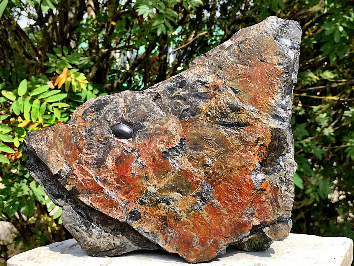
The original 2016 visit recorded plant fragments and root-like impressions in shale among the beach material. Its photographs preserve that historical collecting record. Because the rock came from tipped and wave-reworked spoil, a find’s position on the beach cannot identify its original coal seam or sedimentary bed.
The earlier guide used the names Calamites, Annularia, Asterophyllites and Neuropteris while referring to the wider Whitehaven flora. No independent catalogue of South Beach specimens has established that whole list here. Recognisable stems and foliage can be recorded cautiously, but an incomplete impression should not be forced into a genus or counted as another whole-plant species.
Bivalves, fish remains and corals were also reported in the original account. Their species, abundance and original source beds have not been independently resolved. A shell in Coal Measures material is not necessarily marine, and the mixed spoil cannot reconstruct an upright forest or a repeated natural sequence of leaves and roots.
The original bivalve photograph below is captioned as “marine shale”. That is the historical interpretation attached to the image; the marine or non-marine identity and exact provenance of these loose shells have not been independently confirmed.
Treat this material as a historical record while safe, permitted shore access remains unverified. The photographs and geological studies can be explored without entering the beach. Do not search at the cliff toe, dig into the tip or disturb a structure to obtain a fossil. Any future sampling would require verified safe access and the landowner’s agreement.

Significant discoveries, geological research and conservation milestones at Saltcom Bay.
1830–1838 – West Pier is built
Construction of West Pier helped establish the harbour-side setting beside the present South Beach. It is part of the local industrial landscape, rather than a fossil discovery.
Late 1830s–1840s – Wellington Pit is developed
Wellington coal pit was developed beside the shore during the late 1830s and 1840s. The Candlestick belongs to this colliery’s history; it is not a surviving steelworks chimney.
c.1920 – A photograph records spoil reaching the beach
A photograph of Wellington Pit shows mining waste extending down to the beach. It provides a historical view of how tipping created the artificial coastal ground.
1932 / 1930s – The colliery closes and the artificial coast retreats
Wellington Pit closed in 1932. After tipping ceased, marine erosion progressively cut into the artificial shoreline; an exact date for the last deposit of spoil is not established.
1–3 January 2007 – A fatal collapse prompts geological investigation
A fatal cliff collapse on 1 January was followed by a geological survey on 3 January. The investigation recorded four distinct spoil units and documented the instability of the artificial cliff.
2016–2017 – Coastal inspections document continuing change
Engineering appraisal and inspections recorded retreat of the spoil coast and a circular former mining structure revealed by erosion. These were observations of a changing industrial shoreline, not newly discovered fossil beds.
2020 – The coastal strategy records restricted access
The published coastal strategy recorded beach access prohibited for safety reasons and the cliff-top parking and access road closed. This is a dated historical record; it does not by itself establish whether the same restrictions remain in force today.
GEOLOGY
The low cliff at South Beach is largely artificial ground created by tipping colliery waste. It includes fragments of sandstone, shale and coal, together with industrial debris. These older rocks were mixed and moved by people, then reworked by erosion. The colour or position of a tipped layer does not identify a Carboniferous formation or a particular fossil horizon.
Following the fatal collapse on 1 January 2007, a British Geological Survey inspection on 3 January described four visible units of mine fill. From the top down, they comprised dark-grey gravelly material; loose buff to brown sandstone-rich debris; dark coal, shale and slag; and grey to greenish-grey shale-rich debris. Their textures and tipping patterns are described in the expanded section below.
The report gives clast sizes, including sandstone fragments up to 250–300 mm and coal-shale-slag fragments around 60–80 mm. These numbers describe pieces within the fill, not layer thicknesses. No numerical thickness was recorded for each of the four units, and the photographic section is not a scaled natural stratigraphic log.
BGS mapping places raised-beach deposits beneath the made ground, with Pennine Middle Coal Measures Formation bedrock below. Those natural units are substrate context, separate from the visibly described spoil. They do not establish that every fossil-bearing clast came from the underlying formation or that a complete natural section is exposed here.
The Candlestick belongs to the history of Wellington Pit and is associated with its ventilation works. Wellington was developed during the late 1830s and 1840s and closed in 1932. The artificial shoreline subsequently retreated after tipping ceased. The prominent structure should not be identified as an old steelworks chimney.
The original cliff photograph below retains its historical “Whitehaven Sandstone Series” caption. That attribution is not used for the revised geology: the visible cliff is mixed artificial fill, and individual spoil fragments have not been traced to a single formation, age or mine seam. The natural Saltom Bay sections farther south were not logged beneath these four spoil units.


South Beach’s four recorded colliery-spoil units, mapped substrate and limits of fossil provenance.
This guide’s Saltcom Bay locality is South Beach beside West Pier, immediately south of Whitehaven harbour. Its artificial cliffs were created by colliery spoil tipping. They are separate from the natural Carboniferous and Permian sections farther south in the larger Saltom Bay. The most detailed local geological record is the survey made after the January 2007 landslide; it records a historical exposure, not a safe route or a present-day inspection.
PENNINE COAL MEASURES GROUP
Pennine Middle Coal Measures Formation
Mapped natural bedrock. Geological mapping places Carboniferous mudstone, siltstone and sandstone of the Pennine Middle Coal Measures Formation beneath this locality. This is substrate information, not a complete measured bedrock section exposed for visitors at South Beach. It does not identify the source bed of each rock fragment in the overlying spoil.
Superficial deposits and artificial ground
Raised beach deposits. Mapping shows Quaternary raised-beach sediment beneath the made ground. The 2007 report uses the older Flandrian age term, broadly corresponding to the Holocene. No complete local measured exposure or fossil assemblage was established for these superficial deposits.
The artificial spoil cliff. Four distinguishable units were recorded during the 3 January 2007 survey. They are human-made tipping layers, not four Carboniferous beds. The descriptions below follow the report’s numbers from the top downward. Individual layer thicknesses were not measured and cannot be reliably estimated from the photograph.
Unit 1: upper dark-grey fill. Slightly layered material contains angular to partly rounded fragments reaching coarse-gravel size. It was classified as colliery mine fill used for land raising. Neither a fossil assemblage nor a numerical layer thickness was assigned to it.
Unit 2: sandstone-rich loose debris. Buff, pale-grey and brown sandstone fragments and other mine waste occur in a matrix of gravel, sand and clay. Some angular pieces measure about 250–300 mm, and lenses of the darker Unit 1 material occur within the slightly layered mass. The clast dimensions are not the thickness of the unit.
Unit 3: coal, shale and slag. Dark-grey to black material contains pieces of coal, shale and industrial slag approximately 60–80 mm across. Its condition varies from partly consolidated to loose. Slag is a product of industry, not a naturally deposited fossil-bearing rock layer.
Unit 4: lowest exposed fill. Loose shale fragments and other mine waste, reaching coarse-gravel size, are dark grey, greenish grey or pale grey. Tipped layers are uneven towards the south and more regular towards the north. This was the lowest visible artificial unit in the recorded cliff, not a demonstrated boundary between Carboniferous formations.
Modern loose beach material. Waves rework pebbles, cobbles and debris released from the artificial cliffs. A fossil-bearing stone in that mixture has lost its original stratigraphical position. Its height in the spoil or position on the beach cannot reveal the age or order of the original coalfield beds.
Plant remains in the mixed material. The earlier visit account and photographs record plant fragments and root-like remains in shale. Its names include Calamites, Annularia, Asterophyllites and Neuropteris, but no independent specimen-by-specimen catalogue from this exact beach has been established. These are historical identifications, not a confirmed modern species list or evidence that the plants grew where their fragments now lie.
Other reported fossils. Fish remains, bivalves and corals were also reported in the earlier guide’s mixed finds. Their species, source seams and original environments remain unresolved. In particular, the presence of a bivalve does not establish a marine origin for all the shells: non-marine bivalves also occur in Coal Measures rocks.
What the spoil cannot reconstruct. A complete 30-species flora or repeated in-situ forest floors cannot be inferred from tipped waste. No individual fill unit has been traced to Countess Pit Sandstone, a named coal seam or marine band, or to Bransty Cliff Sandstone or Millyeat members. The original sedimentary sequence and the later order of industrial tipping are different histories.
Separate natural sections farther south. The Saltom Bay Carboniferous conservation section near NX 962 165 and the Permian Barrowmouth exposures farther south have their own measured beds and fossil records. Those natural successions were not logged beneath the four numbered spoil units described at South Beach and are not a substitute for a local bedrock log.
A changing and unstable artificial coast. Wellington Pit and its tipping helped create the harbour-side shoreline. The Candlestick is associated with that coal mine, rather than an old steelworks. After tipping ended, erosion and collapse progressively cut back the artificial ground. The four-unit record helps explain that unstable material; it should not be read as an invitation to inspect cliff faces, enter a closed beach or descend through spoil.
References.
Jenkins and Hobbs (2007), BGS report IR/07/002, South Beach landslide, figure 6 and table 1.
Cumbria Coastal Strategy (2020), St Bees Head to Whitehaven, South Beach appraisal.
Environment Agency: Whitehaven South Beach shoreline-management unit.
National Trust: the history of Whitehaven Coast.
Whitehaven: Seeing History in the View (2012), Wellington Pit and West Pier.
SAFETY
The spoil cliff can fail without warning. The 2007 BGS investigation documented a fatal collapse close to the harbour wall, a further fall during the survey, undermined ground and tension cracks near the cliff top. Stay away from the cliff toe and edge, loose waste, overhangs and apparently stable blocks.
The 2020 Coastal Strategy recorded beach access prohibited for safety, with cliff-top parking and road access closed. This is a dated report, and a current reopening has not been verified. Follow current restrictions, check with the landowner or Cumberland Council before planning a visit, and do not enter when access is unclear.
Dry weather, summer beach levels or later landscaping do not demonstrate that the cliff or route is safe. Never use the South Harbour Wall, a gap in a fence or a descent down the spoil to bypass a restriction.
Even if a permitted route is confirmed open, tides, waves, slippery boulders and falling industrial waste remain hazards. Keep a clear return route and do not approach unstable cliffs. Avoid suspect debris, shafts, old mining structures and any restricted harbour works.
EQUIPMENT
For viewing from an open public route, a camera, binoculars, suitable footwear and weather protection are more useful than collecting tools. Stay well back from edges and do not seek a closer photograph from the spoil or cliff base.
No hammering or splitting visit is recommended while shore access remains unverified. For legally held historical finds, use a hand lens, labels, soft wrapping and a rigid tray to examine and support fragile shale without losing its provenance.
CLEANING AND TREATING
For an existing, legally collected specimen, begin with a soft dry brush and support thin shale slabs. Avoid soaking fragile mudstone or scrubbing dark plant films. Keep counterparts together and label the find as loose South Beach spoil unless a more precise origin is documented.
Do not use acids or aggressive preparation on mixed, unidentified material. Industrial debris may resemble rock or a fossil and should not be cut or ground without knowing what it is. Leave unusual or unstable specimens unprepared for specialist advice; avoid routine varnish or adhesive coatings.
IDENTIFY YOUR FINDS
Need help identifying a fossil? Share clear photos, where you found it and its size with the community.
FURTHER READING
Deposits: the West Cumberland Coalfield rainforest, regional background
Jenkins and Hobbs (2007): BGS South Beach landslide and spoil study
Cumbria Coastal Strategy (2020): St Bees Head to Whitehaven
National Trust: Wellington Pit and Whitehaven Coast history
Environment Agency: Whitehaven South Beach shoreline policy
ACCESS RIGHTS
Confirm the current access position with the landowner or Cumberland Council before planning shore access. The 2020 appraisal recorded a safety prohibition, and a reopening has not been verified. Use only open signed routes and respect every closure, fence and no-access sign.
Public walking access does not grant permission to collect, hammer or excavate. Any proposed collecting would need the landowner’s agreement as well as a confirmed safe, permitted route. Leave the spoil face, harbour structures, mine remains and coastal works undisturbed.
It is important to follow our ‘Code of Conduct’ when collecting fossils or visiting any site. Please also read our ‘Terms and Conditions‘
LINKS
♦ Fossil Discussions
♦ Fossil Articles
♦ Buy Fossils, Tools and Equipment
♦ Buy Crystals, Meteorites, and Artefacts
♦ Join Fossil Hunts
♦ UK Fossils Network


