
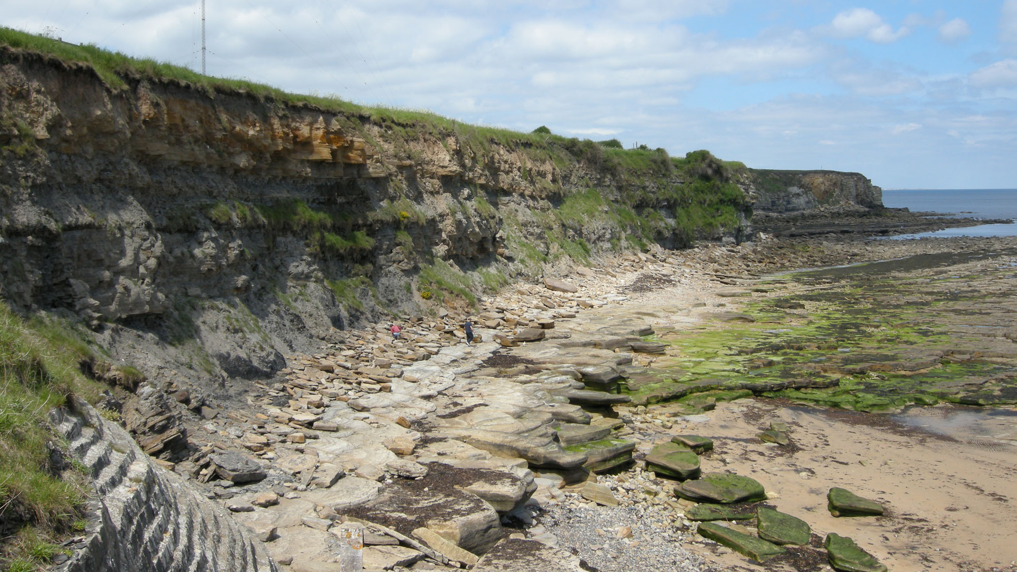
Overview
Directions
- Approach on the A193, north from Whitley Bay or south from Blyth, and follow the local roads to Old Hartley, just south of Seaton Sluice.
- Use Old Hartley car park and follow the coastal access to the steps down towards Hartley Bay. The council lists the car park as free in its September 2026 update; check the signs and any temporary access notices when you arrive.
- From Hartley, follow the foreshore north towards Crag Point when conditions allow. Collywell Bay, Charley’s Garden and the harbour Cut form a further northern continuation, not a single uninterrupted walk available at every tide. Use the safe public cliff-top route instead of rounding a headland when the foreshore is blocked.
- Plan the shore visit around a falling tide and a safe return well before the water reaches cliff bases. Do not descend closed or damaged steps, pass barriers or continue beneath unstable cliffs.
- Hartley starting-area reference: 55.07567°N, 1.46155°W. This locates the Hartley starting area; it is not the harbour Cut or a parking-space pin.
Location photographs
Swipe to browse · Select a photograph to enlarge


Fossil Hunting
The most useful way to explore this shore is to distinguish plant-bearing sandstone and rooted seat-earth from the finer mudstones that contain non-marine shells. Begin with naturally exposed surfaces in stable, accessible positions, observing and photographing the rocks in place. Coal seams and the rooted beds beneath them are part of the fossil landscape themselves. The protected cliffs and rock platforms should not be split, dug into or hammered to reproduce the sections described in older studies.
Plant fragments occur in grey mudstone and sandstone, and loose bark impressions have been recorded on the foreshore. Look for repeated surface patterns, branching root systems and leaf or stem outlines rather than relying on colour alone. Root traces occur in the Hartley seat-earth and sandstone succession. A root system extending through a bed records vegetation growing in that soil; a broken plant fragment lying along a bedding surface may have been transported with the sediment. Most fragments should remain conservatively identified unless diagnostic surface details survive.
At Hartley, the mudstone immediately above the thin Whitley coal is a particularly well-documented fossil horizon. The measured account records non-marine bivalves under historical names including Anthraconaia salteri, Anthracosia phrygiana, A. ovum, Anthracosphaerium forms and Naiadites quadratus, together with scales assigned to Megalichthys and Rhabdoderma. Shells can be flattened or poorly preserved, and isolated scales are specialist finds rather than a promise of complete fish. Ironstone bands and nodules accompany this mudstone; a nodule’s presence alone does not establish that it contains a fossil.
A separate shell-bearing band occurs close to the base of the silty mudstone above the Ellington seam horizon. Thin dark shale rests on ironstone there. Its recorded Anthracosia forms and Naiadites must be kept distinct from the Whitley roof assemblage. In another Hartley exposure, the roof of a 13 cm coal contains small ostracods and coiled encrusting tubes historically called Spirorbis. The tube name does not turn this into a marine coral bed. Orange or brown weathering of sandstone is also not evidence that a rock contains marine fossils.
The northern continuation has its own fossil horizons. At Collywell Bay, cannel coal above a carbonaceous shale has yielded fish debris, small crustacean remains historically called Estheria, and non-marine bivalves recorded as Anthraconaia pulchella, Anthracosia cf. caledonica and Naiadites productus. Farther north, between the Bentinck and Five-Quarter seams in the revised correlation, a thin band within pale mudstone contains many shells preserved in pyrite. These horizons are described separately below; they should not be advertised as though all were exposed beside the Hartley steps.
For useful records, photograph the whole bed or loose block, then the fossil with a scale, and note the exact position, rock type and whether it was in place. Do not assign loose material to a named seam simply because that seam occurs nearby. Historical species lists record specialist determinations and retain qualifiers such as cf. and aff.; the same precision is rarely possible from an incomplete beach fragment. Obtain the relevant permission before removing material, and leave unusual articulated remains, large plant structures and potentially important specimens undisturbed for specialist assessment.

Fossil photographs
Swipe to browse · Select a photograph to enlarge


Discoveries and milestones
Significant discoveries, geological research and conservation milestones at Seaton Sluice.
1761–1764 – The harbour Cut exposes a sandstone section
Thomas Delaval’s new harbour cut created the artificial channel beside Rocky Island. This northern exposure later became a useful place to examine the Seaton Sluice sandstone body and its internal sedimentary structures.
1926 – Coastal coal-seam correlations investigated
Absolom and Hopkins studied the coast between Tynemouth and Seaton Sluice. Their broader coastal work provided an early framework for relating the separated Coal Measures exposures, including those around Hartley and the northern end of the section.
1931 – A newly exposed coal investigated
W. Hopkins examined the identity and geological position of a coal seam exposed on the Seaton Sluice foreshore in the early autumn of 1930. His published study records a specific episode of changing coastal exposure and the continuing difficulty of correlating local seams.
1965 – First SSSI notification
The Tynemouth to Seaton Sluice coast was first notified as a Site of Special Scientific Interest. Its geological exposures became part of a formally recognised conservation site.
1967 – Sandstone bodies and coastal stratigraphy described
Jones distinguished sandstone bodies and coal horizons along the coast. Some of the seam names used in this interpretation were subsequently revised, so the historical labels require careful correlation when reading older accounts.
1970 – Heating beside the Hartley North Dyke documented
Jones and Cooper illustrated progressive contact metamorphism beside the Hartley North Dyke at Collywell Bay. The observations show how a younger intrusion altered the neighbouring sedimentary rocks.
1974 – Measured sections and coal correlations revised
D. H. Land published detailed Hartley, Crag Point and Seaton Sluice sections, together with their fossil horizons and revised seam correlations. The work separated the two Low Main seams and clarified the younger coastal coal sequence.
1980–1984 – Ancient river deposits examined
Haszeldine and Anderton, and later Haszeldine, investigated the deposition of the coastal sandstone bodies. Their work on channel deposits and braided-river bars helped explain the erosive contacts and cross-bedded sandstones exposed around Seaton Sluice.
26 May 1989 – SSSI boundaries revised
The protected Tynemouth to Seaton Sluice site was renotified with revised boundaries. Its recognised interests include the geological coast and the use of the shore by wintering birds.
Geology
The cliffs and foreshore expose the Pennine Middle Coal Measures Formation, within the Pennine Coal Measures Group. The local succession is Duckmantian, traditionally called Westphalian B, in the late Carboniferous. This is an older Coal Measures interval than the Asturian Halesowen Formation, to which the site was previously assigned. Sandstone, siltstone, mudstone, rooted seat-earth and coal form repeated cycles, but their expression changes along the shore and across faults.
The finer beds record low-energy water bodies on a vegetated coastal plain. Mud settled in lakes and related quiet-water settings, preserving non-marine bivalves, ostracods, plant fragments and occasional fish remains. Sand and silt entering these water bodies could build progressively shallower deposits. Rooted seat-earth records a surface colonised by vegetation, while coal represents accumulated plant material. These relationships explain why a coal seam, its underlying soil and its overlying shell-bearing mudstone tell different parts of the same environmental story.
The sandstone bodies add a record of moving water. Ripple lamination, cross-bedding and local erosion surfaces preserve the passage of currents and migrating bedforms. A small sandstone body in the Hartley cliff contains south-dipping lateral-accretion surfaces, interpreted as the growth of a bar in a meandering channel. Larger channel sandstones at Crag Point and the Cut contain coarser sediment and locally cut down into older beds. The direction of cross-bedding records ancient flow; it is not the present regional dip of the entire succession.
Faults make a shoreline walk very different from reading one continuous vertical section. Land’s measured Hartley section lies between the Hartley Steps and Crag Point faults and includes the two distinct Low Main coals. North of the Crag Point fault, younger sandstone appears beside older beds. The Seaton Sluice Sandstone has an erosive base that locally removes the Bensham interval and rests directly on the Table Rocks Sandstone. Their contact represents channel incision and missing strata, rather than a gradual change that can be followed everywhere.
Coal names also require care. Older authors used different correlations for several coastal seams, and “Five-Quarter” has been used both for the Durham Low Main and for a younger seam in Land’s revised scheme. The coal once called the coastal High Main is assigned to the Metal Seam in the revised interpretation; the true High Main is not exposed on this shore. The expanded account keeps the original measured sections and historical correlations separate so that these names do not create an invented stack of beds.
Younger igneous dykes cut the sedimentary sequence near Hartley, Collywell Bay and Seaton Sluice. Their heat locally baked the adjacent rocks and coked coal; altered pale igneous rock was historically termed white trap. These intrusions are a later event, not coal-bearing members or part of the Whin Sill. At the surface, waves exploit joints and softer beds to shape reefs, inlets and the Charley’s Garden stack. Erosion also continually changes exposure and leaves loose material whose original bed may no longer be evident.
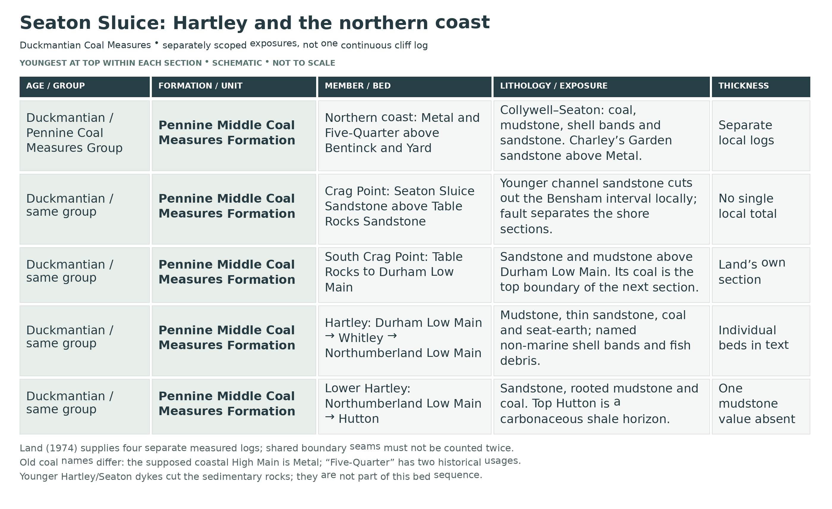
Detailed geology and bed-by-bed succession
Detailed geology: the separately measured Hartley, Crag Point and Seaton Sluice sections, their fossils and historical coal correlations.
This account follows the original Hartley starting area and the separately identified northern exposures at Crag Point, Collywell Bay and Seaton Sluice. Faults, channel erosion and changes in coal correlation prevent the whole coast from being drawn as one uninterrupted measured section. The logs below preserve their own coordinates and top-to-bottom order. Thicknesses in feet and inches are the original published measurements, not estimates of today’s exposure; 1 ft equals 0.3048 m.
PENNINE COAL MEASURES GROUP
Pennine Middle Coal Measures Formation
The local coal-bearing succession is Duckmantian (Westphalian B), late Carboniferous. It comprises repeated sandstone, siltstone, mudstone, seat-earth and coal intervals, with non-marine shell bands and plant remains. The named coals and sandstone bodies used below are individual seams or local units, not formally established members. The former Halesowen Formation / Warwickshire Group assignment is inappropriate for these exposures.
Coal correlations and historical names. Land’s revised scheme correlates Jones’s Bottom Yard with the Upper thin seam, Top Yard with the Yard, Bottom Grey or Stone with the Bentinck, Top Grey or Metal with the Five-Quarter, and High Main with the Metal. The Middle thin seam had no equivalent in that older sequence. In a different older Northumberland usage, “Five-Quarter” also means the Durham Low Main. These are alternative historical correlations, not extra coals inserted into the sequence. The true High Main is not exposed on this coast; an older “Plessey to High Main” summary therefore needs that qualification.
Hartley: the interval between the two Low Main seams. The following section was measured between the Hartley Steps and Crag Point faults, from NZ 3435 7610 to NZ 3455 7560. It is given youngest first, from the Durham Low Main down to the distinct Northumberland Low Main. Fossil names are the historical determinations; qualifiers are retained rather than silently converted into secure modern identifications.
Durham Low Main coal — 2.5 ft. The upper boundary coal of this measured interval. It is distinct from the Northumberland Low Main at the foot of the log.
Seat-earth mudstone — 1.5 ft. Pale grey mudstone immediately beneath the coal becomes carbonaceous at the top. The lower part is silty and contains ironstone nodules.
Fine sandstone — 5 ft. Micaceous, somewhat shaly sandstone shows small-scale cross-bedding. Two sandstone posts are separated by 2 ft of silty mudstone in the published description; that internal mudstone is not silently treated as an additional independently measured bed.
Silty mudstone and shell band — 5 ft. Grey silty mudstone contains, near its base, 2 in of dark shale resting on 2 in of ironstone. Recorded bivalves include Anthracosia cf. aquilina, A. cf. lateralis, A. aff. phrygiana, forms intermediate between aquilina and ovum and between lateralis and ovum, and Naiadites quadratus. The online table’s “quadrates” is a transcription variant; this is not a second species.
Ellington seam horizon. A stratigraphic position, rather than a measured coal thickness, separates the overlying shell-bearing mudstone from the next sandstone. No coal thickness should be inferred from the dash in the original log.
Fine sandstone — 0.75 ft. A thin sandstone directly beneath the Ellington horizon.
Grey silty mudstone — 5 ft. This finer interval separates the two adjacent thin sandstone beds.
Fine cross-bedded sandstone — 2.5 ft. Small-scale cross-bedding is recorded, and the sandstone thins towards the north. Its thickness is therefore not a constant along the whole bay.
Shaly micaceous sandstone — 2 ft. Grey, very shaly sandstone is divided by silty mudstone partings.
Silty micaceous mudstone — 5 ft. Grey mudstone contains thin sandy laminae, recording a finer-grained interval rather than a separate major sandstone body.
Whitley roof mudstone — 4 ft. Grey mudstone contains ironstone bands and some dolomite nodules with cone-in-cone structure. The historical fauna comprises Anthraconaia salteri, Anthracosia phrygiana, A. ovum, an Anthracosia form between aquilina and ovum, Anthracosphaerium aff. radiatum, A. aff. turgidum, and an unnamed form compared with A. propinquum, together with Naiadites quadratus. Fish remains are scales assigned to Megalichthys and Rhabdoderma. Anthracosia beaniana, documented at Whitley Bay, was explicitly not found in the Hartley assemblage.
Whitley coal — 0.5 ft. A thin coal beneath the fossil-bearing roof mudstone.
Whitley seat-earth — 0.5 ft. Grey seat-earth mudstone underlies the coal.
Thin-bedded sandstone — 10 ft. Fine sandstone shows small-scale cross-bedding directed towards the north-west. This direction describes the sedimentary structures in this bed.
Mussel-bearing mudstone — 4 ft. Grey mudstone yielded poorly preserved non-marine shells. The account does not support assigning them the complete fauna of the higher Whitley roof bed.
Black shale — 1.5 ft. Fish debris occurs in the dark shale immediately above the lower coal.
Northumberland Low Main coal — 5 ft. The lower boundary coal of the measured section. A later excursion account gives approximately 1.7 m for the Low Main exposure; preserve that as a separate description rather than rounding it into an identical measurement.
Hartley: Hutton to Northumberland Low Main. A fourth original section, around NZ 3450 7565 between the Hartley Steps and Crag Point faults, extends below the Northumberland Low Main. It is listed top to bottom and has its own measurements. The Northumberland Low Main at its top is the same named boundary seam at the base of the earlier Hartley log, not an additional coal.
Northumberland Low Main coal — 5 ft. The top coal of this lower interval.
Seat-earth mudstone — 1.5 ft. The seat-earth lies immediately beneath the coal.
Fine sandstone — 10 ft. Thin bedding, cross-bedding and thin shaly partings are recorded.
Grey silty mudstone — thickness not stated. Fine sandstone partings occur in its upper part. The thickness cell in the retained original table is blank; no value is inferred from adjacent rows.
Top Hutton horizon — 1.33 ft. Carbonaceous shale contains coal laminae. The six-inch geological map labels this interval Top Hutton; the published decimal thickness is retained as printed.
Rooted grey mudstone — 3 ft. Root traces and ironstone nodules occur in this mudstone.
Grey mudstone — 2 ft. The bed becomes silty downwards and contains some ironstone nodules.
Grey silty mudstone — 1.5 ft. The lower part is particularly silty.
Fine micaceous sandstone — 5 ft. The sandstone lies above the lower Hutton coal.
Hutton coal — 0.5 ft. The six-inch map calls this seam Bottom Hutton. It is distinct from the carbonaceous Top Hutton horizon higher in this local log.
Hartley: additional observable horizons. The following field observations are separately located features. They are not extra beds automatically appended to Land’s measured log.
Rooted substrate beneath the Low Main. Near the southern access steps, a pyritic seat-earth with roots overlies fine sandstone. Ripples, burrows, bioturbation and scours are recorded in this interval. Rooting structures record vegetation; no independent total thickness is supplied here.
Thin coal and its roof fauna. On the promontory north of the steps, a 13 cm coal has a roof mussel band containing ostracods and small coiled tubes historically called Spirorbis. A thin, convoluted sandstone occurs about 1 m below the coal. Its named-seam correlation is not established by this description and must not be assumed.
Small lateral-accretion sandstone. About halfway up the Hartley cliff, south-dipping internal surfaces record lateral growth in a meandering channel. These bar-accretion surfaces should be distinguished from the overall dip of the enclosing strata. No total thickness is assigned.
South side of the Crag Point fault: beds above the Durham Low Main. Land’s separate cliff section at NZ 3433 7607 is listed top to bottom. Its basal coal is the same named Durham Low Main that tops the Hartley log; it must not be counted twice as two successive seams.
Table Rocks Sandstone — 12 ft. Brown, micaceous, medium-grained sandstone with cross-bedding.
Pale grey mudstone — 8 ft. The fine-grained interval beneath the upper sandstone.
Micaceous sandstone — 10 ft. Fine sandstone contains silty shale partings.
Plant-bearing mudstone — 3 ft. Grey mudstone is silty in places and contains plant fragments.
Durham Low Main coal — 2.5 ft. The coal at the base of this separate measured section. The excursion account describes the seam as about 1 m in its own exposure account; that value is not substituted for Land’s measurement.
Crag Point sandstone bodies and channel incision. On the north, downthrown side of the fault, the lower, relatively fine Table Rocks Sandstone was historically called the Lower Crag Point Sandstone. Wedge- and trough-shaped cross-bedding occurs with ripple and horizontal lamination. It contrasts with the coarser sandstone above, rather than forming a simple continuation of every bed south of the fault.
Seaton Sluice Sandstone. This unit includes the historical Upper Crag Point and Upper Seaton Sluice sandstones and is also exposed at the Cut and Rocky Island. Its erosive base can remove the Bensham interval and rest directly on the Table Rocks Sandstone. Basal material includes quartz pebbles and clasts of coal, ironstone and mudstone; west-directed cross-bedding records the movement of the coarser channel sediment. Baryte cement occurs locally at Crag Point. The 12–14 m thickness in the conservation synthesis describes the outcrop unit, not a new measurement of the Hartley log.
Basal pebbles and contrasting sandstone facies. At Seaton Sluice, Land records a basal layer of calcite pebbles up to 2 in across, possibly produced by replacement of siderite; the illustrated sample is from NZ 3393 7677. In the Cut, the lower fine-grained, argillaceous sandstone has south-east-directed cross-bedding. Quartz and siderite pebbles, coal clasts and plant material occur above the erosive base of the coarser, more feldspathic upper sandstone, which has conspicuous garnet concentrations. The upper sandstone has sheet-like bedding and planar, with less common trough, cross-bedding. These local facies observations supplement the erosive contact; they are not new formal units.
Northern continuation: Collywell Bay to Seaton Sluice. The following coals and interseam beds belong to specified northern exposures. Their relationships use Land’s revised correlation; they are not all visible in one continuous cliff face.
Middle thin equivalent and cannel roof, Collywell Bay. At NZ 340 763, 2.5 ft of carbonaceous shale represents the Middle thin horizon, with 4 in of cannel at its roof. The fossil record includes Anthraconaia pulchella, Anthracosia cf. caledonica, Naiadites productus, crustacean material historically called Estheria, and fish debris. The spelling pulchella resolves the online memoir’s inconsistent OCR; it is not a new taxonomic revision.
Thin clay above the cannel. A clay layer 1 in thick lies 3 ft above the cannel at Collywell Bay. Illite, chlorite and authigenic baryte are recorded, with petrographic specimen E37830 illustrating the mineralogical evidence. This is a specific thin horizon, not a separate formation.
Upper thin seam. This named coal is recorded at Collywell Bay. The 11–20 in range in the memoir also includes Newsham and New Hartley observations; it is a multi-locality range, not a precise thickness established for one Collywell exposure.
Upper sandstone below the Yard. At NZ 3395 7668 on the Seaton Sluice foreshore, the sandstone is metamorphosed beside the Seaton Sluice Dyke. Towards the north-east it can merge with the lower named sandstone, although separate sandstone tongues occur elsewhere. No exact thickness for this spot is assigned.
Yard Seam. The coal is present at Collywell Bay and Seaton Sluice, with local coking against the Hartley North and Seaton Sluice dykes. Shingle cover and earlier working can obscure its outcrop. The memoir’s 30–40 in figure is regional; it is not an exact thickness recovered for this shore.
Yard to Bentinck: separate interseam section. Land described these beds south of the Seaton Sluice fault at NZ 3392 7668, with a similar exposure at Collywell Bay, NZ 3395 7636. The following paragraphs proceed upwards from the Yard; their individual measurements belong to this account rather than the earlier Hartley log.
Lower mudstone above the Yard — 5 ft. Grey mudstone contains silt partings.
Middle sandstone — 10 ft. Fine-grained sandstone shows cross-bedding.
Upper mudstone — 14 ft. Thin sandy interbeds occur centrally, with ironstone nodules near the top.
Bentinck Seam — about 1 ft. The coal above the mudstone is poorly exposed. It is the same named lower boundary coal in the next log, not an additional seam.
Seaton Sluice: Bentinck to the lower leaf of the Five-Quarter. The separate measured section at NZ 3389 7665 is given youngest first. “Five-Quarter” here is the younger seam in Land’s scheme, not the Durham Low Main under an older local name.
Five-Quarter bottom leaf — 0.75 ft. Shaly coal at the top of this measured interval.
Seat-earth mudstone — 1.5 ft. The rooted-soil interval beneath the shaly coal.
Grey mudstone — 6 ft. Thin sandstone partings interrupt the mudstone.
Fine micaceous sandstone — 4 ft. A sandstone between the two main mudstone intervals.
Fossiliferous pale mudstone — 10 ft. Thin sandstone partings and ironstone bands occur in mudstone that becomes silty at its top. About 5 ft above the base, a band only a few inches thick contains non-marine shells, mostly preserved in pyrite. The historical identifications are Spirorbis sp., Anthraconaia cf. pumila, Anthracosia aquilinoides, A. caledonica ?, A. cf. planitumida, A. simulans, Anthracosphaerium turgidum and Naiadites productus. Its precise equivalence with other named Bentinck roof bands is not settled here.
Poorly exposed shaly beds — about 3 ft. The source explicitly records limited exposure; no more detailed internal subdivision is justified.
Bentinck coal — about 1 ft. The lower boundary coal of this section, also recorded in the preceding interseam account.
Five-Quarter main seam. At NZ 3387 7663, the main coal is 2 ft thick; a lower 9 in leaf of shaly coal lies 3 ft beneath it. The lower leaf is the 0.75 ft coal at the top of the preceding log, not an extra seam to be added twice. This is the younger Five-Quarter of the revised correlation.
Metal Seam. The same Seaton Sluice locality has a poorly exposed coal about 4 ft thick, separated from the Five-Quarter by a few feet of mudstone. It is the coal formerly called High Main in the coastal correlation, not the true High Main of the wider coalfield.
Sandstone above the Metal: Charley’s Garden. Sandstone with silty partings and south-south-east to south-east cross-bedding forms the stack at NZ 3396 7657 and adjacent foreshore. Erosion along joints helps isolate the stack. The conservation synthesis gives approximately 22 m for the composite sandstone body; the memoir’s photograph describes a stack about 20 ft high. These are different quantities, and neither establishes one accessible present-day 22 m vertical face.
Younger intrusive dykes. Hartley South, Hartley North and Seaton Sluice dykes cut the sedimentary sequence. The Hartley North dyke is locally 5–9 ft wide and the Seaton Sluice dyke about 6 ft; pale white-trap alteration and baking or coking of neighbouring coal are recorded. They are later intrusions and do not belong among the sedimentary seams or constitute the Whin Sill.
References.
D. H. Land (1974), Geology of the Tynemouth district, Geological Survey memoir: Hartley and Seaton coastal sections, coal correlations and dykes.
B. R. Turner, Carboniferous and Permian rocks between Tynemouth and Seaton Sluice, excursion account, particularly localities 5–6.
Tynemouth to Seaton Sluice, British Upper Carboniferous Stratigraphy, Geological Conservation Review.
British Geological Survey, Pennine Middle Coal Measures Formation, modern stratigraphic framework.
Safety
The tide reaches the cliff bases and can cut off sections of foreshore. Check local tide times, swell and weather before setting out, keep an escape route in view and turn back before water closes it. A low predicted tide does not remove the danger from waves or a rising sea.
Crag Point and the surrounding cliffs include unstable faces, faults and fallen blocks. Stay well away from cliff bases and edges, do not shelter beneath overhangs, and never climb or hammer a face. Use only open steps and established public paths; recent falls or damaged access may make part of the old route unsuitable.
Wet sandstone, mudstone, algae and uneven reefs can be very slippery. Wear secure footwear, keep children close and avoid jumping between isolated rocks. The Cut and harbour margins have steep drops and water hazards; observe them from a safe lawful position rather than treating the harbour as a collecting excavation.
Equipment
Take sturdy boots with good grip, local tide information, a map, a charged phone, a hand lens and a camera with a small scale. A notebook is useful for separating observations at Hartley, Crag Point, Collywell Bay and the Cut.
If removal of a loose specimen has been expressly permitted, carry soft wrapping and a rigid box for fragile shale and plant impressions. A hammer or chisel is not a routine requirement for observing this protected coast, and this guide does not recommend splitting bedrock or excavating shell bands.
Cleaning And Treating
Photograph and label an authorised specimen before cleaning, retaining its precise find point and any known horizon. Support thin mudstone or shale slabs across their whole surface. Allow damp material to dry slowly at room temperature, then try a very soft dry brush on loose dirt, stopping immediately if the fossil surface or carbon film starts to lift.
Do not routinely soak, scrub or force shale apart. Some of the documented shell beds contain pyrite, so persistent damp storage and unnecessary wet cleaning are poor choices. Keep dry specimens in stable indoor conditions and seek conservation advice if a pyritic specimen develops cracking or powdery alteration. Avoid household acids, bleach, varnish and indiscriminate coatings. Leave delicate or potentially significant material unprepared until a specialist has examined it.
Identify Your Finds
Need help identifying a fossil? Share clear photos, where you found it and its size with the community.
Further Reading
Geologists’ Association / Yorkshire Geological Society excursion: Hartley and Seaton Sluice within the wider coastal route
D. H. Land (1974): Geology of the Tynemouth district, including Hartley and Seaton measured sections
Geological Conservation Review: Tynemouth to Seaton Sluice
BGS: Pennine Middle Coal Measures Formation
Natural England: Tynemouth to Seaton Sluice SSSI
Northumberland County Council: coastal car parks
Access Rights
The geological coast forms part of Tynemouth to Seaton Sluice SSSI, and the wider shore also has protected wintering-bird interests. Keep to lawful public access, follow current notices and avoid disturbing feeding or roosting birds. The existence of a path or steps does not confer a right to remove fossils.
Observe and photograph the in-situ features without damaging them. Before extracting or removing material, establish the landowner’s permission and any Natural England consent required for the proposed activity. The site’s listed potentially damaging operations include extraction, clearance of loose rock and alteration of geological features; they do not amount to a general visitor collecting licence. Consult the official site record and current local instructions.
It is important to follow our ‘Code of Conduct’ when collecting fossils or visiting any site. Please also read our ‘Terms and Conditions‘
Links
♦ Fossil Discussions
♦ Fossil Articles
♦ Buy Fossils, Tools and Equipment
♦ Buy Crystals, Meteorites, and Artefacts
♦ Join Fossil Hunts
♦ UK Fossils Network


