
Overview
Directions
- Approach Thurso on the A9 and follow the A836 towards the east side of the River Thurso. The locality is beyond Thurso Castle, on the eastern shore; do not head west towards Scrabster.
- From Thurso East, follow the coastal approach past the ruined castle and farm, then continue east towards the rocky shore. Keep to the established path, respect signs and avoid farm working areas and the castle ruins.
- The old guide used a farm track and parking area beyond the castle. Check local signs and permission before driving along that track or parking there; otherwise leave your vehicle in a lawful town parking place and approach on foot.
- Original locality reference: 58.59973°N, 3.50745°W. This marks the guide locality, rather than a parking space or a safe route across the shore. Plan the visit around a falling tide and keep a clear route back.
Location photographs
Swipe to browse · Select a photograph to enlarge


Fossil Hunting
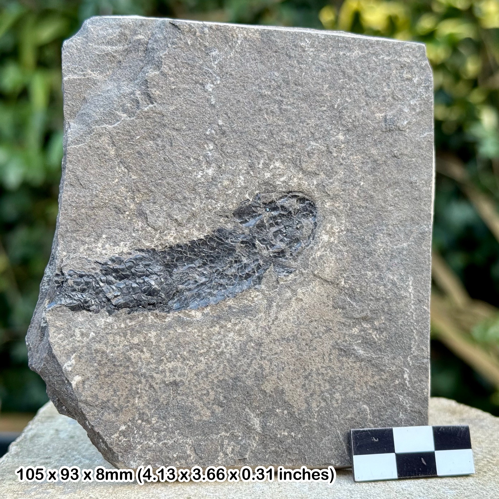
Start by looking closely at naturally exposed surfaces on loose slabs and accessible rock platforms. The useful material is usually a scattering of fish scales and broken bones rather than an outline of a complete animal. The original photographs show dark, contrasting fragments in grey flagstone, sometimes concentrated on a single surface. A hand lens and a little patience are more useful for recognising these remains than breaking large quantities of rock.
Look for repeated scale shapes, patterned surfaces and thin pieces of bony plate standing out against the fine-grained matrix. Some slabs contain several overlapping fragments; others show only an isolated patch. Photograph a promising surface with a scale, then record where the slab lay and whether it was loose or still part of a bed. A loose beach specimen may have moved, so its findspot alone does not establish the exact fossil-bearing layer. The gallery illustrates the variety of fragmentary material without assigning each photograph to a species.
Smooth, calcareous flagstones are an important fish-bearing rock type in the historical description of the coast. In the measured partial section about a mile east of Thurso, two separate blue calcareous intervals contain fish remains. These alternate with paler flags, mudstones, sandy layers and unusual beds containing pieces of sandstone. Fossils are therefore concentrated in particular parts of a repeated sequence; they are not equally abundant in every layer. The published log helps explain what to look for, but it is not a bed-by-bed route to the photographed specimens.
The early Survey account records Glyptolepis paucidens and Dipterus valenciennesi from smooth calcareous flags in its wider coastal discussion. These are historical regional-coastal records, not identifications of the fragments illustrated here. A more specifically eastern record is the small branchiopod originally called Estheria membranacea, treated in the later BGS regional account as Asmussia murchisoniana. It is a crustacean, not a fish. The old guide’s confident assignment of common armour to Homosteus milleri cannot be confirmed for every fragment, and differences between blue and black preservation do not by themselves identify different species.
Whole fish and well-preserved associated material deserve particular care. The wider Caithness flagstone succession includes exceptional complete specimens, but these should not be promised on this short stretch of shore. Nor should every rounded object be treated as a fish-bearing concretion: the conspicuous historical ‘nodule beds’ described here largely contain reworked sandstone pieces. Leave anything potentially important in place, photograph it and seek specialist advice before attempting removal. Search only where it is safe to do so, and obtain the appropriate permission before taking specimens.
Fossil photographs
Swipe to browse · Select a photograph to enlarge




Discoveries and milestones
A chronological record of fossil collecting and geological investigation on the shore east of Thurso.
8 April 1845 – Robert Dick describes the eastern shore
In a letter to Hugh Miller, Robert Dick described a geological walk past Thurso East Castle towards Murkle. He recorded fossil-rich calcareous rocks, fish scales and bones, together with changes in bedding and local disturbances. His account provides an early detailed record of the eastern shore, although the historical fossil names cannot simply be transferred to modern species.
21 July 1845 – Thurso East specimens sent to Hugh Miller
Dick sent Miller a parcel of fossils from several named Caithness localities, including bones and a substantial skull fragment specifically identified as Thurso East material. Keeping those locality labels separate matters: the whole parcel did not come from this beach, and it does not establish an exact site of origin for every famous large fish later associated with Thurso.
1914 – Repeated lake deposits documented in a measured section
C. B. Crampton and R. G. Carruthers documented a partial coastal section about one mile east of Thurso. Their 14-interval log included two separate fish-bearing calcareous flagstone beds, cracked mudstones, ripple-marked sandy layers and recurring sandstone-fragment beds. It remains a useful record of sedimentary repetition, provided its historical Mey Beds terminology is distinguished from the modern mapped formation.
Geology
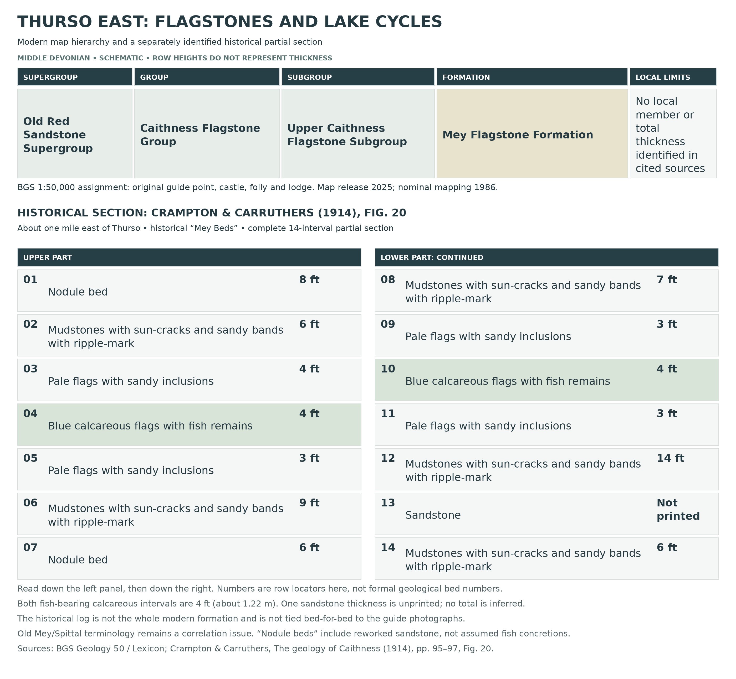
The Thurso East shore is built from Middle Devonian sedimentary rocks of the Old Red Sandstone succession. BGS’s current 1:50,000 bedrock mapping assigns the original guide locality and the area around Thurso Castle and Lady Janet’s Seat to the Mey Flagstone Formation. This belongs to the Upper Caithness Flagstone Subgroup, within the Caithness Flagstone Group. The mapped rock types are sandstone, siltstone and mudstone; calcareous flagstones and their fossils are described in the detailed historical coastal sections.
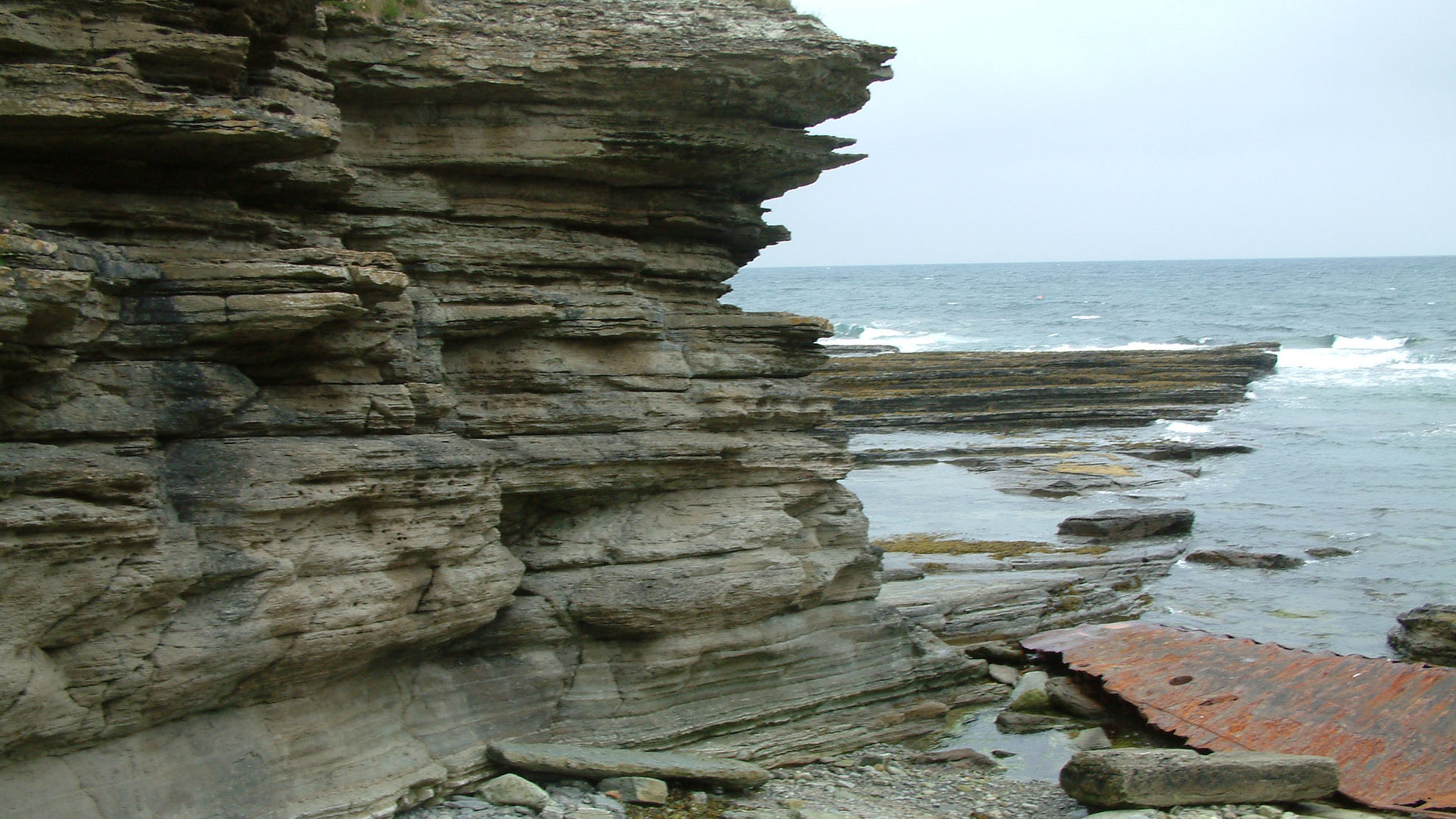
These rocks record repeated changes in a large lake system. Fine sediment and carbonate accumulated during quieter, deeper-water phases, producing smooth, fish-bearing flagstones. Shallower phases brought sandy material, ripples and muddy surfaces that dried and cracked. Repetition of these conditions built a layered succession rather than one continuous fish bed. The contrast between resistant beds and more readily weathered layers helps produce the stepped cliffs and broad platforms visible on the shore today.
Some of the most distinctive beds contain angular to rounded pieces of sandstone in a sandy mudstone matrix, together with crumpled sandstone layers. The 1914 Survey called these ‘nodule beds’. Their fragments were derived locally from sediment already present in the succession, rather than being a collection of foreign pebbles carried a long distance. The authors discussed movement of partly consolidated sediment and rewetting of dried lake-floor mud. That historical explanation should be distinguished from the observation itself: the beds preserve disruption and reworking within the lake sediments.
The historical names need care. ‘Mey Beds’ in the early memoir, later local references to ‘Spittal Beds’, and today’s mapped Mey Flagstone Formation are not interchangeable labels for an independently proven set of individual beds. The digital map release dates from 2025, but its Thurso and Wick source mapping has a nominal year of 1986; it is not evidence of a new field survey in 2025. The chart therefore separates the current mapped hierarchy from the complete historical partial section, rather than combining them into a falsely precise modern log.
Detailed geology and bed-by-bed succession
Explore the mapped geological hierarchy, lake-deposit cycles and historical measured section east of Thurso.
Scope and age. This account concerns the shore east of the River Thurso, around the original guide locality and the coast beyond Thurso Castle. The current mapped age is Middle Devonian. The mapped hierarchy and the historical measured log below answer different questions: the map identifies the rock unit at 1:50,000 scale, while the old log records a particular partial exposure about one mile east of Thurso. Their individual beds have not been correlated to every photograph or to a precisely surveyed modern route.
OLD RED SANDSTONE SUPERGROUP
The flagstones form part of the continental Old Red Sandstone succession. The local evidence is dominated by lake sedimentation, with repeated changes in water depth and periods of exposed muddy lake floor. The term Old Red Sandstone does not mean that every bed is red or that every layer is sandstone: the Thurso sequence includes grey calcareous flags, greenish mudstones and pale sandy beds.
CAITHNESS FLAGSTONE GROUP
The group provides the regional framework for the layered Devonian lake deposits of Caithness. Thin bedding and contrasts between mud-rich, sandy and carbonate-rich sediment account for the flaggy appearance. Disarticulated fish remains are particularly associated with some calcareous beds. Neither a regional formation list nor a regional fish assemblage should be read as a list of units or species proved on this short shore.
UPPER CAITHNESS FLAGSTONE SUBGROUP
This is a subdivision of the Caithness Flagstone Group in the mapped hierarchy, not an Upper Devonian age label. Its regional description includes laminated carbonate-rich siltstones and shales with subordinate thin fine-grained sandstones. The Lexicon gives a regional thickness of about 1,500 m and a Givetian age, but those figures do not establish either the thickness or a precisely resolved stage for the original guide exposure. The formation record and current local map give Middle Devonian; that broader age is retained here.
Mey Flagstone Formation
The current BGS 1:50,000 bedrock data assign the guide coordinate and independently located points at the castle, eastern folly and lodge to this formation. Its mapped lithology is sandstone, siltstone and mudstone. The Lexicon identifies Upper Caithness Flagstone Subgroup as its parent and lists Mey Subgroup as an obsolete name; it supplies no formation thickness or defined upper and lower boundary descriptions. No named member or measured complete modern formation section has been established for this guide.
Mapping and historical names. The current digital record is version 9.25, released on 31 March 2025, and cites Thurso and Wick mapping with a nominal year of 1986. The release date is not a field-resurvey date. Early accounts used Mey Beds as a lithological subdivision, while later local field accounts also used Spittal Beds for eastern exposures. Differences between regional subgroup schemes and map-sheet formations were discussed in the 2005 BGS biostratigraphical framework. A mapped Mey assignment does not by itself resolve those historical correlations or establish a particular fish zone.
Local structure and exposure. The early Survey describes low cliffs and shore reefs along the Thurso–Castletown coast, generally with a gentle north-north-westerly dip, together with local disturbances and joints. Its broader coastal observations should not be turned into exact fault positions on the present walking route. Around the eastern shore, resistant flagstone layers form extensive low platforms separated by steps and joints. Modern beach debris and displaced slabs lie on top of the bedrock and should be distinguished from an in-situ layer when recording a fossil.
The repeating sedimentary cycle. Crampton and Carruthers describe dark blue-grey calcareous flags with smooth bedding surfaces and abundant fish remains as the deeper-water part of their coastal sequence. These weather pale blue and can show yellow, pink and blue colours. Paler flags contain numerous small sandy inclusions, sometimes elongated, crossing or star-shaped, which stand proud of a weathered surface. Thin sandstone layers may carry similar raised networks on both surfaces. Some inclusions are calcareous or tubular, and small marcasite nodules were also recorded. Such mineral or sedimentary structures should not automatically be identified as fish remains.
Shallow water and drying. Pale to greenish mudstones have desiccation cracks and thin, ripple-marked sandstone bands. Successive ripple surfaces can have different orientations; the authors interpreted this as very shallow lake water stirred by winds from changing directions. Their broader coastal description records cracks commonly three to four inches wide and polygons reaching two feet or more across. Sandy crack-fill may connect with the overlying sand layer, while some cracks contain small curled fragments of calcareous mud. These are observations from the described coastal succession, not measurements of every bed on this visit.
Sandstone and “nodule beds”. Fine-grained pale yellowish, reddish or grey sandstone may have contorted bedding, ripple marks and fragmentary plant remains in the wider described cycle. Its place may be taken partly or wholly by “nodule beds”: crumpled sandstone layers or angular to rounded sandstone pieces in greenish sandy mudstone. The fragments match nearby sediment and no foreign stones were found in the described material; some beds pass laterally into sandstone. The 1914 authors considered earth creep or small movements of dried and rewetted lake-floor sediment a plausible explanation. This is a historical interpretation, and these intraformational fragment beds must not be confused with a demonstrated layer of fossil-bearing concretions.
Historical partial section, youngest at the top. Figure 20 of the 1914 memoir illustrates the following 14 intervals in the historical Mey Beds, at a coastal section described as about one mile east of Thurso. The positions below are reading aids, not formally named or numbered beds. Thicknesses retain the source’s feet. The sandstone near the base has no printed thickness, so no complete thickness is calculated. This is a partial measured section illustrating sedimentary repetition, not the full modern Mey Flagstone Formation.
Uppermost recorded interval: nodule bed, 8 ft. The top of the illustrated section is a sandstone-fragment bed overlying the upper cracked-mudstone and ripple-marked sandy interval. It belongs to the recurring intraformational “nodule bed” lithology described above; the figure does not assign it a fish fauna or a formal bed name.
Second interval: mudstones and sandy bands, 6 ft. Mudstones with sun-cracks and sandy bands with ripple marks underlie the upper nodule bed. Their paired structures record exposure and shallow-water movement within this part of the cycle, rather than a continuously deep-water fish-bearing deposit.
Third interval: pale flags, 4 ft. Pale flagstones with sandy inclusions separate the upper cracked-mudstone interval from the upper fish-bearing flags. The inclusions are a sedimentary characteristic of the pale flags; they are not an independently named fossil horizon.
Fourth interval: upper fish-bearing calcareous flags, 4 ft. Blue calcareous flags with fish remains form the upper of the two explicitly fish-bearing intervals in the diagram. It is about 1.22 m thick by conversion from the printed measurement. The figure does not identify the fish species in this individual interval.
Fifth interval: pale flags, 3 ft. Another pale, sandy-inclusion-bearing flagstone interval lies immediately below the upper fish flags and above the thicker cracked-mudstone interval. Its repetition above and below fish-bearing lithology is part of the cyclic arrangement, not evidence for a separate formation.
Sixth interval: mudstones and sandy bands, 9 ft. This thicker package contains sun-cracked mudstones and ripple-marked sandy bands. It separates the pale flags beneath the upper fish-bearing interval from the lower of the two nodule beds shown in the log.
Seventh interval: nodule bed, 6 ft. The second sandstone-fragment bed lies between two cracked-mudstone and sandy-band packages. Its recurrence at another level is important: the fragment-rich beds are repeated sedimentary features, not one unique horizon that can be followed from a photograph alone.
Eighth interval: mudstones and sandy bands, 7 ft. Sun-cracked mudstones with ripple-marked sandy bands occur below the lower nodule bed. This is the upper muddy-sandy part of the lower repeated sequence shown in the figure.
Ninth interval: pale flags, 3 ft. Pale flags with sandy inclusions separate that muddy-sandy package from the lower fish-bearing calcareous flags. No species or separate formal member is assigned to this interval in the measured figure.
Tenth interval: lower fish-bearing calcareous flags, 4 ft. Blue calcareous flags with fish remains repeat the lithology of the higher fish-bearing interval. This bed is also about 1.22 m thick. The two occurrences must both be retained; they should not be merged into a single “fish bed” or assumed to contain an identical named assemblage.
Eleventh interval: pale flags, 3 ft. Sandy-inclusion-bearing pale flags immediately underlie the lower fish-bearing interval. They form the transition to the thickest single mudstone-and-sandy-band package printed in the section.
Twelfth interval: mudstones and sandy bands, 14 ft. The lower cracked-mudstone and ripple-marked sandy package is the thickest interval with a stated measurement in the figure. It lies above the sandstone whose thickness is unprinted. The figure provides no additional internal bed-by-bed measurements for this package.
Thirteenth interval: sandstone, thickness not printed. A sandstone layer separates the 14-ft package from the basal recorded mudstones and sandy bands. Its drawn height is not a substitute for a numerical thickness, and no value has been inferred from the illustration.
Lowest recorded interval: mudstones and sandy bands, 6 ft. Sun-cracked mudstones and ripple-marked sandy bands form the bottom of the illustrated partial log. This is the lowest interval shown, not a demonstrated basal boundary of the modern formation.
Fossils and correlation limits. The memoir’s wider coastal discussion reports Glyptolepis paucidens and Dipterus valenciennesi from smooth calcareous flags, but does not place those species in each of the two measured fish intervals. The old eastern record of Estheria membranacea is treated by the later BGS regional synthesis as Asmussia murchisoniana, a branchiopod. Records separately attributed to Murkle Bay or the western shore have not been imported here. Modern formation mapping cannot alone identify the photographed fossils or settle the taxonomic and correlation issues noted in later BGS work.
References
Crampton, C. B. & Carruthers, R. G. (1914). The geology of Caithness, Memoirs of the Geological Survey, Scotland, pp. 66 and 94–97, Fig. 20.
British Geological Survey. Mey Flagstone Formation and Upper Caithness Flagstone Subgroup, Lexicon of Named Rock Units; BGS Geology 50 bedrock data, version 9.25, Thurso and Wick source mapping.
Johnstone, G. S. & Mykura, W. (1989). British Regional Geology: Northern Highlands of Scotland, fourth edition.
Newman, M. J. & Dean, M. T. (2005). A biostratigraphical framework for geological correlation of the Middle Devonian strata in the Moray-Ness Basin Project area, BGS IR/05/160.
Safety
Visit on a falling tide in calm conditions, check local tide times and allow a generous margin for the return. Water and breaking waves can reach the cliff foot and cover low platforms, cutting off an apparently easy way back. Do not rely on the tide table alone when a swell or onshore wind is driving water onto the shore. Turn back while your route is still clear.
Wet flagstone and seaweed can be extremely slippery. Gaps between slabs, loose blocks and sharp edges add to the difficulty, so wear footwear with a good grip and keep clear of cliff bases, overhangs and unstable faces. Do not climb to reach a fossil. The concrete folly at Lady Janet’s Seat and the castle ruins are landmarks, not shelters or safe climbing structures; rusted wreck material on the shore should also be avoided.
Equipment
Take sturdy footwear, warm waterproof clothing, tide information, a phone, a hand lens, a small ruler and a camera. A notebook or a location record is important because the relationship between a specimen and its bed can be more valuable than an isolated name. Where removal of a loose specimen has been permitted, use padding and a rigid box to protect thin slabs and fragile exposed surfaces.
These hard rocks can fracture unpredictably. Do not bring tools with the assumption that hammering the platforms, cliffs or attached slabs is acceptable. Any permitted preparation of loose material needs appropriate eye protection and controlled working conditions away from other visitors; large slabs and promising in-situ specimens are best left for specialist assessment.
Cleaning And Treating
For a lawfully collected specimen, begin with photographs and a record of its locality and original orientation. Let wet flagstone dry slowly at room temperature, supported flat, and remove loose grit with a soft dry brush. Thin layers can separate and fish surfaces can lift with the matrix, so avoid soaking, forceful scrubbing or trying to split a slab simply to make it thinner.
Do not use household acids, bleach, wire brushes or varnish. Hard calcareous matrix can be difficult to remove without damaging bone or scales; seek advice before mechanical preparation or consolidation. Keep matching pieces together, retain any counterpart and leave potentially important material unprepared until a specialist has examined it.
Identify Your Finds
Need help identifying a fossil? Share clear photos, where you found it and its size with the community.
Further Reading
BGS: Northern Highlands of Scotland, Devonian lake deposits (regional background)
The geology of Caithness (1914): eastern coastal section and Figure 20
BGS: Middle Devonian biostratigraphy and correlation
Robert Dick’s 1845 description of the eastern shore
NatureScot: Scottish Fossil Code
Access Rights

Follow the Scottish Fossil Code. Responsible pedestrian access does not give a right to remove fossils or rock. Establish permission from the relevant landowner or mineral-rights holder before collecting, respect any site conditions and avoid damaging rock exposures.
The original guide’s blanket SSSI statement should not be applied to this eastern locality. Pennylands SSSI is west of the river, and the original guide coordinate falls outside the SSSI polygons checked in NatureScot’s mapping. That point check does not certify the whole walk or exclude every other protection. Consult current maps and local notices for the part of the coast you intend to visit, and seek NatureScot advice where protected-site consent may be relevant.
Use the coastal approach considerately around the farm and keep gates as found. A walking route is not permission to drive along a private track, use a farm parking area or extract specimens. Leave the cliffs, rock platforms and attached beds undamaged, and report scientifically important finds with their exact locality and geological context.
It is important to follow our ‘Code of Conduct’ when collecting fossils or visiting any site. Please also read our ‘Terms and Conditions‘
Links
♦ Fossil Discussions
♦ Fossil Articles
♦ Buy Fossils, Tools and Equipment
♦ Buy Crystals, Meteorites, and Artefacts
♦ Join Fossil Hunts
♦ UK Fossils Network


