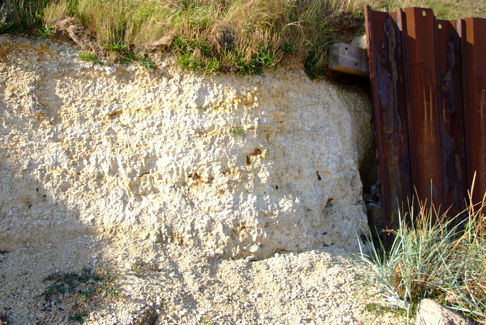
Trimingham is noted for some of the youngest Chalk exposed onshore in Britain, brought within reach when Ice Age glaciers displaced and folded large masses of bedrock. Near Little Marl Point, soft Lower Maastrichtian chalk contains small oysters, belemnites and other marine fossils, while more extensive foreshore sections appear only when beach conditions allow. The familiar oyster-rich beds are just one part of a much richer historical succession. Visit for careful loose-beach collecting and geological observation, rather than excavation of the fragile exposures. Access, sand cover, tides and active cliff movement can all change what is safely visible.


FIND FREQUENCY: ♦♦♦ Fossils occur in loose beach material, but shifting sand and recent erosion strongly affect what is exposed.
CHILDREN: ♦♦ A visit requires close supervision, careful tide planning and a wide clearance from actively slipping cliffs.
ACCESS: ♦♦ The established Vale Road gap is steep and narrow, with limited parking. Check its current condition and keep to signed public access.
TYPE: Cliff geology and loose foreshore material.
DIRECTIONS
♦ Take the small, unmarked road mapped as Vale Road from the coastal road between Trimingham and Mundesley. It leads towards the beach, with a small parking area above the shore. The nearby Trimingham Beach map listing gives NR11 8DT; use this as a nearby postcode, not a verified formal car-park postcode. Park only where permitted and follow current restrictions. The approach includes a narrow, steep descent; check current signs before driving down and be prepared to turn back if the route is closed or unsuitable for your vehicle.
♦ Parking at the shore approach is limited, rather than the large open parking area described in older guides. Do not obstruct the access or assume that cliff-edge ground is stable. No independently verified parking postcode is given here: use the named Vale Road access and current mapping rather than a nearby holiday park’s postcode.
♦ The historical Trimingham Chalk locality includes Little Marl Point at the eastern end of the beach and intermittent foreshore exposures towards the west. Current parish boundaries place the gap just beyond Trimingham, but the established geological locality name remains Trimingham. Stay within a short low-tide return route; do not extend the walk towards Sidestrand without a separate access and tide plan.
♦ What3Words collecting area: ///towers.mirroring.tuck
FOSSIL HUNTING
Oysters in soft white chalk. Small oysters are the most characteristic fossils of the Little Marl Point beds. The familiar historical name Ostrea lunata is generally presented in the modern geological literature as Agerostrea lunata. Some layers contain concentrations of these delicate shells. Look for loose pieces of fossiliferous chalk and naturally weathered specimens on the open shore; do not scrape a cliff face to reproduce a historic collection.
Belemnites and associated fossils. Published Trimingham collections include Belemnella obtusa in lower parts of the composite succession and Belemnella sumensis in higher beds. Species identification requires more than the general bullet shape of a worn guard. Brachiopods, echinoids, sponges and small bivalves also occur, but which groups are represented depends on the chalk interval that has been exposed or eroded.
The richer grey-chalk record. The intermittently exposed Beacon Hill Grey Chalk Member has yielded echinoids including Cardiaster granulosus, Gauthieria princeps and Echinocorys limburgica. Documented oysters include Gryphaeostrea canaliculata and large Pycnodonte vesiculare; brachiopods include Neoliothyrina obesa, Cretirhynchia limbata, Magas chitoniformis, Terebratulina gracilis and Trigonosemus pulchellus. These are scientific records from the broader Trimingham composite section, not a promise that the small oyster-bearing exposure beside the access yields them all.
A hand lens can reveal shell ornament, small encrusting organisms and sponge textures. Some specimens survive mainly as moulds. Keep loose flint fossils, chalk specimens and fossils in other erratic rock types separately labelled: glaciers and waves have mixed material from different sources.
Record the date, exact findspot, matrix and whether the specimen came from loose debris or a recognisable exposure. Do not break protected bedrock, clear a face or collect bulk chalk for microfossils without the relevant permissions. Leave substantial associated material intact and ask for advice before preparation.


A chronological record of fossil discoveries, geological research and conservation milestones at Trimingham.
1824 – Distinctive Trimingham Chalk recognised
Richard Cowling Taylor recognised that the Trimingham Chalk differed from the chalk around Norwich and occupied a higher part of the succession.
1882 – Unusual belemnites recorded
The Geological Survey memoir recorded belemnites from Trimingham that differed from the familiar Norwich forms. Their full significance for establishing a Maastrichtian age was understood only later.
1900–1908 – Brydone mapped the fossil succession
R. M. Brydone documented the fossils and changing chalk masses. His 1908 subdivision distinguished the Porosphaera Beds, Sponge Beds, white chalk below and within the oyster-rich interval, and the Grey Beds.
1949 – Exceptional foreshore exposures photographed
J. E. Sainty recorded folded chalk exposed on the foreshore. The photographs preserved evidence of structures and beds that would later be concealed or removed by erosion.
1951 – Maastrichtian belemnites identified
J. A. Jeletzky’s study of Trimingham collections recognised Belemnella and confirmed their Maastrichtian significance, replacing the assumption that the assemblage was simply the usual Campanian Belemnitella mucronata fauna.
1958 – European correlation refined
Jeletzky placed the Trimingham succession within a more detailed European belemnite framework and showed that it belonged to the Lower Maastrichtian, with the basal part of the stage missing from the historically studied sequence.
1976 – Highest grey chalk logged
A. A. Morter of the British Geological Survey logged and collected a favourable foreshore exposure of the Beacon Hill grey chalk in the western mass. The work captured detail from one of the youngest preserved onshore chalk intervals.
1990 – Named chalk members established
M. B. Johansen and Finn Surlyk revised the succession using brachiopods and lithology, introducing the local member framework that relates the Sponge Beds, Little Marl Point and Beacon Hill grey chalk.
1993 – Cliffs protected as a combined SSSI
Sidestrand and Trimingham Cliffs was notified under modern conservation legislation, recognising the Chalk, Pleistocene deposits, vertebrate fossils, landsliding and soft-cliff habitats.
2001 – Composite succession synthesised
A detailed geological conservation synthesis brought together the historical foreshore logs, the Little Marl Point exposure and fossil correlations, while explicitly recognising gaps and uncertainty between separate chalk masses.
GEOLOGY
A young part of the Chalk succession. The famous Trimingham rocks belong to the Lower Maastrichtian, late in the Cretaceous Period. Their soft white and grey chalk, flint bands, marl seams and shell-rich beds developed in a marine environment. The locality preserves a younger part of the onshore Chalk record than most familiar English collecting sites, but it does not extend to the end of the Cretaceous.
The composite succession is described using the Sidestrand Chalk, Trimingham Sponge Beds, Little Marl Point Chalk and Beacon Hill Grey Chalk members. These are local subdivisions within the White Chalk Subgroup. The BGS Lexicon treats “Trimingham Chalk” as an informal term rather than a fully established formation, so there is no need to invent a formal parent formation for the visitor guide.
Chalk transported by ice. The chalk appears in detached masses among much younger Pleistocene deposits. Ice moved, tilted and folded the slabs; erosion then cut through them at the modern coast. The small Little Marl Point section and occasional chalk on the beach are remnants of more extensive masses recorded by earlier geologists. Their present position does not represent a normal sequence of chalk deposited above glacial sediment.
Exposure changes the collecting experience. The Little Marl Point beds are oyster-rich, whereas the higher Beacon Hill grey chalk has a more diverse fossil assemblage. These intervals are not all permanently visible together. Sand, coastal defences, cliff falls and changing sea levels cover or reveal the shore, and nineteenth-century descriptions cannot be followed as a current map of accessible outcrops.

Detailed geology and stratigraphy of Trimingham.
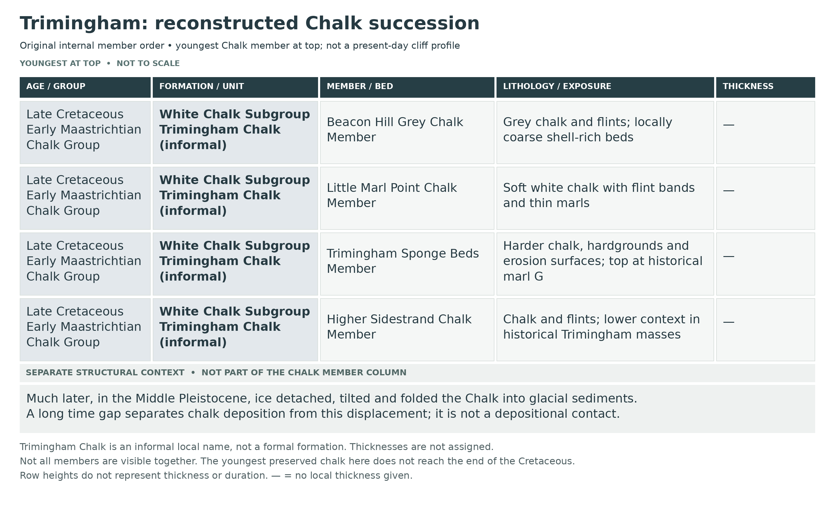
A reconstructed succession in separate chalk masses
The original stratigraphic order is described from lower to higher beds. Little Marl Point’s cliff section and the intermittent foreshore masses preserve different intervals. The letters identify flint or marl markers in published logs, not newly named formal beds; they are not reliable present-day waypoints.
Chalk Group
These Late Cretaceous marine rocks were detached and moved during the Pleistocene. Their fossils date chalk deposition, not the younger glacial host.
White Chalk Subgroup — informal Trimingham Chalk
BGS advises informal usage of Trimingham Chalk because its full distribution and formal attribution remain unresolved. The local member sequence is useful without inventing a Trimingham Chalk Formation. The preserved upper succession is Lower Maastrichtian, not end-Cretaceous.
Sidestrand Chalk Member: lower context
Only the higher part of this member was included in the historical Trimingham foreshore exposures. Fuller lower sections belong to the separate Sidestrand locality. This distinction prevents the whole regional composite from being presented as an accessible log at Little Marl Point.
Historical upper Porosphaera Beds
The 1961 composite explicitly includes the old Trimingham foreshore masses down through marker R. The following R–O interval therefore belongs to their historical record, although it is not a complete present-day section at Little Marl Point.
Flint R
A band of medium-sized cavernous flints marks the lowest part of the historically documented Trimingham interval included here.
Chalk between R and Q
Relatively soft whitish chalk contains few flints and abundant Belemnella in the historical composite.
Flint Q
Huge black tabular flints form a conspicuous marker above the softer chalk.
Chalk between Q and P
Nodular white chalk contains scattered branching flints and grey lenticular streaks or patches.
Flint P
Large black cavernous flints with white cavities lie below the hard chalk at the approach to the Sponge Beds.
Hard chalk between P and O
Whiter chalk passes upwards into very hard grey chalk containing Ventriculites and other fossils. The overlying O marker introduces green pebbles resting on marl.
Trimingham Sponge Beds Member
BGS’s reviewed scheme gives about 2.9 m of indurated chalk with green-coated pebbles, erosion surfaces and flints, bounded above by the “greasy” marl G. This is a published stratigraphic estimate, not a measured thickness of the present small outcrop.
Basal hardground O
The historical composite marks green-coated pebbles on marl at the transition into the Sponge Beds.
N rough grey chalk
The historical composite describes rough grey chalk with white patches above the O basal marker.
M patchy chalk and marl
Patchy grey and white chalk shows manganese on joint surfaces; green pebbles lie at its base above a strong marl band.
L white-chalk and manganese-stained interval
The log distinguishes a thin white-chalk band with green pebbles at its base on a marl seam. Beneath it is grey, crumbly, manganese-stained chalk grading down into white chalk with a marl band. These historical subdivisions are retained without presenting diagram measurements as current outcrop thicknesses.
K sponge-bearing hard chalk
The upper historical sponge sequence includes hard grey chalk, branching flints and conspicuous sponge remains.
Flint J
The lowest of three labelled medium-sized flint bands lies within rusty, hard, lumpy, sponge-bearing chalk.
Flint I
A separate middle flint band occurs in the same hard sponge-bearing interval; the flints have carious cavities.
Flint H
The highest of the three labelled flint bands lies below the strong greasy marl G.
Marl G — upper Sponge Beds boundary
This prominent marl defines the boundary used by the modern member scheme; historic shore-to-bluff correlation was not entirely certain.
Little Marl Point Chalk Member
The member combines the old white chalk without and with Ostrea lunata, now generally recorded as Agerostrea lunata. BGS summarises about 5–6 m of soft white chalk with four flint seams and two marls. The published bluff log contains additional upper flints not shown in the earliest diagram.
Lower oyster-poor chalk: G to F
Soft chalk above G lies below the main oyster-rich interval. A weaker marl occurs beneath the F flints.
Flint F and onset of the oyster-rich interval
F is an open double flint band in the historical log; the oyster was not recorded below this level.
Marl E
A separate marl occurs above F within the white-chalk succession.
Flint D
A higher flint horizon lies in chalk containing common oysters.
Flint C
Oysters also occur at this higher marker; old shore-to-bluff correlations become less secure above it.
Flint B
The revised GCR bluff log retains the earlier B flint but also records higher levels, warning against treating the early diagram as complete.
Higher oyster-rich interval: alpha and beta
The revised log distinguishes two higher labelled levels, alpha and beta, in chalk with abundant oysters. These are later local log labels, not a proven one-to-one replacement for the older A boundary; historical shore-to-bluff correlations above C remain uncertain.
Basal grey chalk — historical boundary A
The first soft grey beds define the base of the Beacon Hill Grey Chalk Member in the reviewed scheme. The letter is a local stratigraphic label, not a younger geological age.
Beacon Hill Grey Chalk Member
BGS describes at least 5 m of grey chalk with flint bands. The richer fauna includes echinoids, brachiopods and oysters. Its most informative detailed log came from a temporary foreshore exposure, so the entire interval must not be promised at the access point.
Lower large-Pycnodonte horizon
The historical Mass C log records large Pycnodonte near the base of the logged grey-chalk succession.
Sponge concentration
A separate sponge-rich level lies above the lower large-oyster horizon.
Lower diverse belemnite and brachiopod concentration
The next fossil concentration includes abundant Belemnella, together with Neoliothyrina, Cretirhynchia, Chatwinothyris, Magas and the echinoid Cardiaster.
Large-Belemnella and Chatwinothyris horizon
A higher, separately labelled concentration contains large Belemnella and Chatwinothyris.
Cretirhynchia retracta and oyster horizon
Above this, the log identifies Cretirhynchia retracta, Terebratulina, Magas, Chatwinothyris and oysters.
Higher Belemnella and Chatwinothyris horizon
Another belemnite–brachiopod concentration occurs higher in the flinty grey chalk. Repeated genera do not make these individually plotted horizons the same bed.
Rich fauna below Flint Z
The higher fossil-rich interval includes Neoliothyrina, large Galerites, Gauthieria, Pycnodonte and long plicate oysters.
Flint Z
The named upper flint marker lies above that rich assemblage and below the highest labelled echinoid–brachiopod horizon.
Echinocorys and large-Neoliothyrina horizon
The highest labelled fossil concentration contains Echinocorys and large Neoliothyrina. The preserved top terminates against Quaternary till; it is not a Cretaceous–Palaeogene boundary.
Fossil zones and numerical precision
The member scheme spans the Belemnella obtusa to Belemnella sumensis succession. Zone names are correlation tools, not additional lithological beds. Heights read approximately from a diagram have not been presented as exact field measurements.
Albion Glacigenic Group — much later host
The chalk slabs lie within younger glacial deposits. This separate framework describes emplacement and cover; it is not a continuation of Cretaceous deposition.
Sheringham Cliffs Formation: local glacial framework
The wider Trimingham coast contains folded glacial sands, silts, clays and till. The full regional formation inventory should not be transferred to the small Little Marl Point chalk face.
Bacton Green Till Member
The regional till is stratified stony diamicton with sorted sediment interbeds. Near Trimingham its upper boundary can pass into clay and sand members, while elsewhere it is truncated by later deposits. This variable geometry prevents a universal simple layer stack.
Marl Point basal glacitectonite — A4 structural horizon
Lee and colleagues describe a 0.3–0.5 m zone bounded by lower and upper detachments. Low-angle north-dipping thrusts cut thin slices of folded sand and clay. This measured structural horizon belongs to Marl Point, not the different A3 zone at Paston.
Marl Point overlying traction till
Massive, silty, strongly consolidated brown to brown-grey diamicton overlies the deformed basal zone. It is interpreted as till deposited beneath grounded ice.
Transition into stratified diamicton
The till grades upwards into layered diamicton with sand laminae and lenses, silt and clay beds, and occasional dropstones. The interpretation changes upwards from deposition beneath ice to sedimentation in water near the ice margin; this is a local transition, not an additional formal member.
Trimingham Clay Member
This clay-rich upper subdivision belongs to the glacial framework documented in the wider Trimingham sections. It must not be confused with marl G or the thin marl seams inside the much older chalk slabs.
Trimingham Sand Member
The separately named sand subdivision occurs in the wider glacial succession. The Bacton Green Till description records transitions into the Trimingham clay and sand members, but no complete local bed log or constant thickness is transferred to Little Marl Point.
Briton’s Lane Formation
Glacial outwash caps parts of the wider coastal succession. Its basal contact may be erosional or affected by thrusting.
Beacon Hill Sand and Gravel Member
Shelly sand with ripple and cross-bedding contains flint-gravel seams and local periglacial structures. Its distribution includes the Marl Point–Trimingham stretch, but the approximately 12 m thickness belongs to the Gimingham Quarry stratotype. This Pleistocene name must not be confused with the Cretaceous Beacon Hill Grey Chalk Member.
Glacial deformation and modern erosion
Later research recognises multiple detachments and deformation episodes along the Trimingham coast. Rafts, folds and shears can interrupt or repeat older sediments. Modern landslips then alter the face again; neither a historical photograph nor a reconstructed bed column guarantees safe or continuous present exposure.
References
BGS. Chalk stratigraphic framework RR/05/01: local member boundaries and scoped thicknesses.
BGS Lexicon. Informal Trimmingham Chalk.
Peake and Hancock (1961). The Upper Cretaceous of Norfolk, figure7 and accompanying Trimingham account.
Mortimore, Wood and Gallois (2001). Overstrand to Trimingham Cliffs, GCR23, especially figure4.36.
BGS. Mundesley and North Walsham district, sheets132/148.
BGS Lexicon. Beacon Hill Sand and Gravel Member.
Lee and colleagues (2017). Middle Pleistocene glacial evolution of northern East Anglia.
SAFETY
The access road is narrow and steep, with limited space to pass or turn. Check for closures and do not park close to an eroding edge or block the route. Avoid using informal cliff paths or landslips as shortcuts.
Visit on a falling tide and return well before water reaches the base of the cliffs or defences. Wooden revetments do not guarantee protection from cut-off, and damaged timber or exposed fastenings can be hazardous. Keep off the structures and rock armour.
Stay well clear of both the soft high cliffs and small chalk faces. Falls can occur without warning, and a hard hat does not make working beneath unstable material safe. Wet chalk, seaweed, loose flints and deep mud require care; children need close supervision and should remain on an open, safely accessible part of the shore.
EQUIPMENT
Bring tide information, a charged phone, grippy footwear, a hand lens, camera and small rigid boxes with soft padding. Fragile oysters need individual protection. Hammers, picks and tools for cleaning a cliff face are not appropriate for the recommended loose-beach visit.
CLEANING AND TREATING
The small oyster shells can separate or flake when soft chalk dries or is scrubbed. Photograph them first, retain a supporting margin of chalk and begin with a very soft brush. Do not try to release every shell from a dense shell bed. A small intact piece showing several oysters is often more informative and robust than loose broken valves.
Only sound specimens should receive gentle fresh-water cleaning; avoid prolonged soaking or repeated wetting and drying of friable chalk. Allow ordinary stable wet material to dry gradually. Do not use acids, bleach, wire brushes or routine varnish. Where a sponge has pyrite preservation, keep the assessed dry specimen away from damp and seek advice if powdering or staining develops. Leave unusual or scientifically important material unprepared until it has been examined.
Identify your finds
Need help identifying a fossil? Share clear photos, where you found it and its size with the community.
FURTHER READING
BGS: informal Trimingham Chalk
JNCC: Trimingham Chalk and its fossil succession
BGS: Mundesley and North Walsham district geology
BGS: the Chalk stratigraphic framework
Field guide: Little Marl Point and the Trimingham shore
Trimingham Village Hall Trust: 2026 beach observations
Norfolk Museums and council: responsible fossil collecting
ACCESS RIGHTS
The Trimingham collecting coast is within Sidestrand and Trimingham Cliffs SSSI. Its fossils, glacial structures and active cliff processes are protected scientific features. Follow signs and landowner requirements, collect only permitted loose beach material and obtain the appropriate permissions before excavating, clearing an exposure or taking bulk samples. Public access and the presence of an old collecting description do not give automatic permission to remove fossils from the face.
It is important to follow our ‘Code of Conduct’ when collecting fossils or visiting any site. Please also read our ‘Terms and Conditions‘
LINKS
♦ Fossil Discussions
♦ Fossil Articles
♦ Buy Fossils, Tools and Equipment
♦ Buy Crystals, Meteorites, and Artefacts
♦ Join Fossil Hunts
♦ UK Fossils Network