
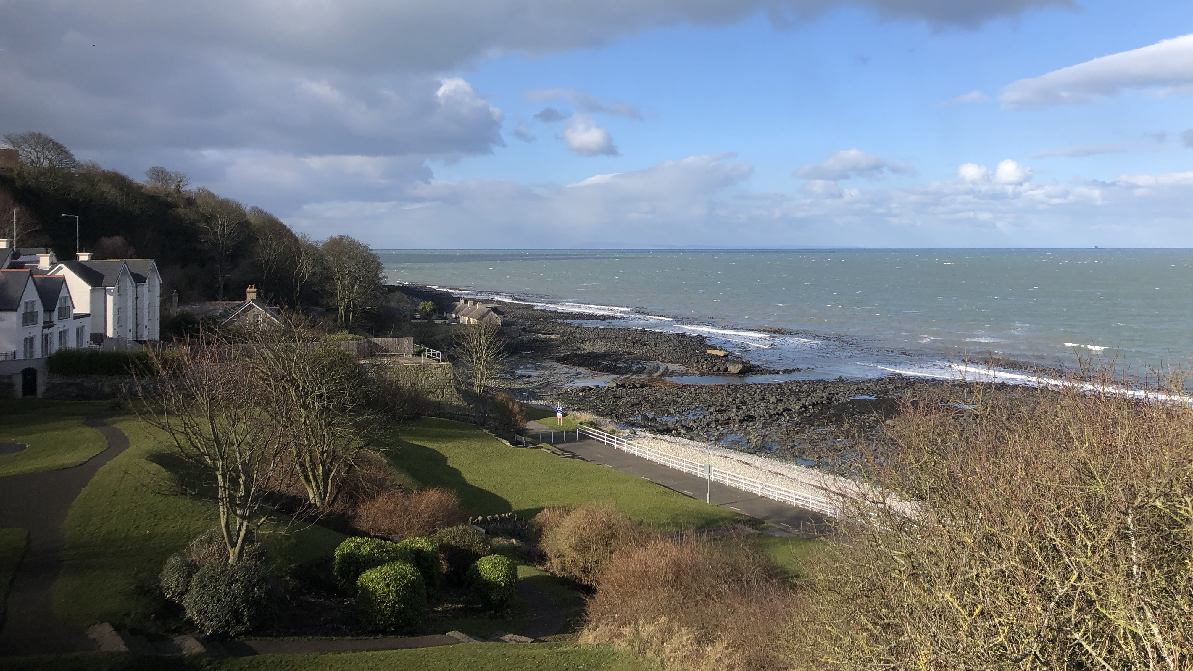
Overview
Directions
- Waterloo Bay lies just north of Larne harbour. From the A2 Glenarm Road, the Town Park approach leads by paved, sloping and stepped paths towards the bandstand and promenade. Follow the signed public paths and use the established shore steps.
- An alternative approach starts beside the leisure centre at the southern end of the promenade. University College Cork’s fossil-site guide gives the parking point as 54.8551, −5.80114; walk north along the coastal path to the shore steps at 54.8606, −5.80701.
- The promenade is approximately 1 km long and has geological interpretation panels. Plan the foreshore part of the visit around low tide and return before rising water restricts the route.
- The published Waterloo Bay reference point is 54°51′32.8″N, 5°48′29.0″W. The existing locality postcode is BT40 1DZ; use the named access points above rather than treating the postcode as a precise parking entrance.
Location photographs
Swipe to browse · Select a photograph to enlarge


Fossil Hunting
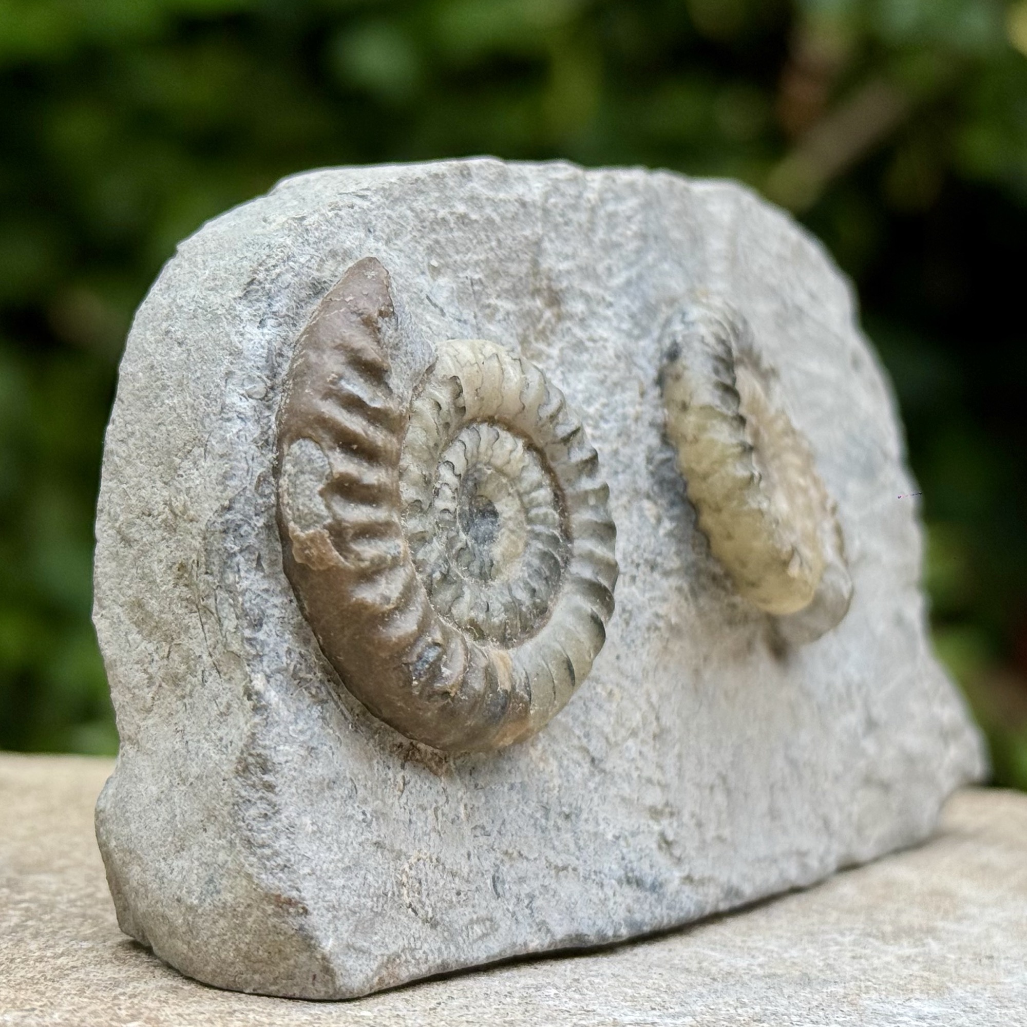
Begin by looking closely at the exposed surfaces of the dark grey mudstone ledges rather than trying to prise fossils from them. Coiled ammonites and pale bivalve shells can stand out against the darker rock. Low tide gives the most complete view; shingle, boulders and seaweed can cover much of the section at other times. The exposures near the northern shore access are in the Jurassic part of the succession, whereas a walk south towards the leisure centre takes you down through older rocks.
The earliest local ammonites include Psiloceras erugatum in Bed 24, followed by Neophyllites and, higher still, Psiloceras planorbis. Later forms include the weakly ribbed Psiloceras plicatulum and Caloceras. Some shells are flattened in mudstone, while pyrite or early carbonate cement can preserve others in relief. These named horizons come from detailed scientific logging; loose ammonites cannot normally be assigned to a bed simply by where they lie today. Photograph the whole coil and any ribs, include a scale, and record the surrounding rock when visible.
Bivalves are an equally useful part of the shore’s fossil record. Look for curved oyster shells, paired valves, isolated impressions and thin concentrations of broken shells. Gryphaea has the familiar strongly curved oyster form illustrated in the photographs here, but not every curved shell belongs to that genus. Detailed Waterloo sampling published in 2012 recorded mussel-like Modiolus minimus, robust Cardinia regularis and the large bivalve Plagiostoma giganteum, among other forms. These are research identifications, not a claim that every weathered shell can be named to species. Examine shell shape, ornament and matrix together; loose specimens may have travelled from their original bed.
The smaller fauna is worth noticing as well. Crinoid stem pieces are built from tiny repeated plates, and Waterloo material is now assigned to Isocrinus angulatus. Echinoid spines and plates include Diademopsis serialis; exceptionally, small articulated brittle-stars have been found. These are research records, not a claim that complete examples are common on the beach. A lens can help distinguish organised skeletal pieces from irregular mineral grains, while burrows and trails record animals that left no shell behind.
The older Penarth Group beds have a different character. Westbury Formation shales preserve thin shell concentrations and fish remains; the 2012 Waterloo samples include the characteristic bivalve Rhaetavicula contorta. Higher levels contain different bivalve associations and evidence of animals burrowing into the sea floor. The same study also documented small gastropods, including material identified as Pseudokatosira undulata, in the younger sampled succession. These smaller remains reward a hand lens and careful photographs. Changes in shells, burrowing and sediment colour reveal the changing environment, even where no large fossil is visible.
Marine reptile remains and unusually well-preserved small invertebrates make this a significant research locality, but they are exceptional discoveries rather than an expectation for an ordinary visit. If you notice possible bone, an articulated animal or an unusual fossil association, photograph it with a scale and record its position without disturbing the exposure. Seek advice from a museum or geologist before attempting removal or preparation. The ASSI protects the geological record as well as individual specimens: check the landowner’s permission and relevant NIEA consent requirements before removing material or using tools.
Fossil photographs
Swipe to browse · Select a photograph to enlarge


Discoveries and milestones
Significant fossil discoveries, geological research and conservation milestones at Waterloo Bay, Larne.
1864–1867 – Early published geological studies
Ralph Tate’s studies included the Larne coastal succession, placing these fossil-bearing beds within the developing understanding of the Lower Lias of north-east Ireland. The nineteenth-century work provided a foundation for later local stratigraphic investigations.
1961 – Rare fossil foliage documented
T. M. Harris, with geological notes by J. S. Jackson, described a frond identified as Otozamites bechei from Waterloo’s Rhaetian rocks. This rare plant record adds a land-derived component to the marine succession; its exact bed was not established.
1975 – The Rhaetian and Lower Jurassic succession reviewed
Howard Ivimey-Cook reviewed the eastern Antrim succession following drilling of the Larne borehole, including the Waterloo foreshore exposures. Later detailed studies built on this work, while introducing their own bed-numbering scheme rather than treating every numbered unit as directly interchangeable.
1995 – Waterloo ASSI declared
Waterloo was declared an Area of Special Scientific Interest on 17 July, recognising the value of its geological succession. This protects the exposed record for research and public understanding; it does not turn public access into a licence to collect.
1999 – The Larne Sea Dragon discovered
Brian McGee, a mature student at Queen’s University Belfast, spotted fossil bones on the shore. His tutor Alastair Ruffell alerted the Ulster Museum, and two blocks were excavated with Environment and Heritage Service assistance. Preparation by Andy Cowap revealed parts of an ichthyosaur’s backbone, ribs, limbs and jaw, with teeth, forming the most complete ichthyosaur reported from Northern Ireland.
2003 – Soft-sediment deformation investigated
Michael Simms examined the contorted Cotham Member sediments and compared them with disturbed beds elsewhere in Britain. The work drew attention to a widespread deformation event and raised an impact hypothesis; subsequent investigations have reassessed its cause, so an impact is not an established explanation.
2004 – Type section of the Waterloo Mudstone Formation
The Waterloo shore was designated the type section for the formation that encompasses Northern Ireland’s preserved Lias Group. This gives the exposure a formal role in describing and comparing the region’s Lower Jurassic rocks.
2006–2007 – Detailed logs and a proposed Jurassic boundary stratotype
Andrew Jeram and Michael Simms produced detailed sedimentological and fossil logs, followed by a proposal to use Waterloo as the global reference section for the base of the Jurassic. Their expanded ammonite succession made the site an important candidate. The global reference was subsequently ratified at Kuhjoch in Austria, rather than at Waterloo.
2012 – A sampled record of ecological change
Luis Felipe Opazo Mella analysed 36 samples from the Waterloo section for his study of extinction and recovery in marine invertebrate communities. The work recorded changes in the sampled fauna through the succession, extending the site’s importance beyond ammonite correlation to the ecology of the Triassic–Jurassic transition.
2021 – Formation boundaries and boundary correlations revised
Andrew Jeram, Michael Simms, Stephen Hesselbo and Robert Raine combined high-resolution carbon-isotope measurements with the fossil succession. They revised the local Langport and Waterloo Mudstone boundaries and set out competing correlations for the Triassic–Jurassic boundary, rather than assigning it to the first Psiloceras planorbis.
2021 – Echinoderm identifications reassessed
Michael Simms reassessed the Irish Triassic and Jurassic echinoderm record. Waterloo crinoids provisionally regarded as an unnamed species were assigned to Isocrinus angulatus, while small brittle-stars from the Johnstoni Subzone were compared cautiously with Aplocoma brevispina. The revision shows why historical provisional names should not be treated as settled species identifications.
Geology
Waterloo Bay exposes the change from a Late Triassic landscape influenced by arid conditions to the shallow seas of the Early Jurassic, around 201 million years ago. The beds dip north-west, so walking south along the coast generally takes you into older strata. Faults interrupt parts of the section, and the wide rock platform exposes different levels depending on the tide and beach cover. It is a geological succession to read across the shore, rather than a cliff in which every bed is stacked conveniently above the next.
The oldest mudstones belong to the Mercia Mudstone Group. Pale green silty beds of the Collin Glen Formation lie beneath the darker marine shales of the Westbury Formation, but later heating has altered the colour of a much thicker interval here, making the lower Collin Glen boundary difficult to identify. The Westbury beds record the arrival of the sea through dark mud, shell concentrations and fish debris. Storm waves intermittently reworked the sea floor, leaving shell-rich surfaces and sandstone structures; a fault removes some of the local Westbury record.
The succeeding Lilstock Formation records further changes in water depth and sediment supply. Its Cotham Member contains thinly alternating mud, silt and sand, ripples and conspicuous contortion produced before the sediment hardened. Some of the disruption is interpreted as earthquake-related, but a single impact or mega-tsunami is not established. Even the cracked surface once treated as straightforward evidence of drying has been reassessed: many cracks better resemble those formed within submerged sediment. Above, the Langport Member is mostly mudstone with silty and shelly horizons, rather than the thick white limestone seen at some southern British localities.
The Waterloo Mudstone Formation, within the Lias Group, records increasingly persistent marine conditions. Its lower part consists mainly of rhythmic mudstone, shale and calcareous mudstone; ammonites first appear well above its base, and limestone bands become more conspicuous higher up. Pyrite and early carbonate cement sometimes preserve fossils in relief, while shells in less-cemented mudstone can be flattened. Burrowing, shell concentrations and changing organic-carbon content reveal shifts in bottom-water conditions and the supply of sediment. Much later heat from an inferred buried intrusion hardened parts of the succession and impaired the preservation of some microscopic organic remains.
The site is scientifically valuable because its expanded sedimentary record can be compared with other sections across the Triassic–Jurassic transition. Modern work combines ammonites with carbon-isotope changes, rather than equating the first familiar ammonite with the start of a period. The precise boundary here remains uncertain between upper Langport beds and the lower Waterloo Mudstone succession. The formal Jurassic reference point is in Austria; Waterloo’s former candidacy and continuing research importance do not make it the ratified global boundary section.
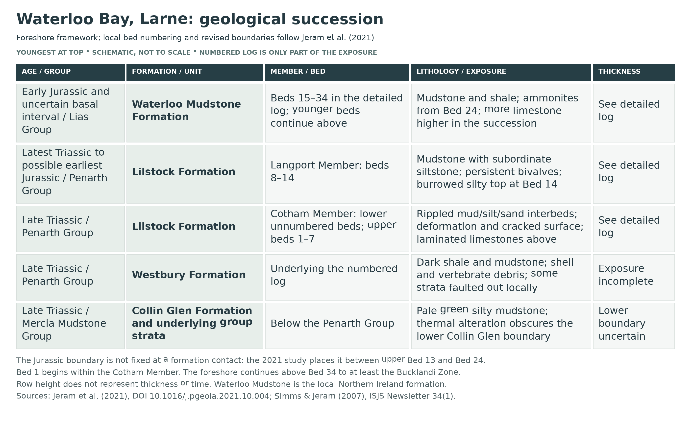
Detailed geology and bed-by-bed succession
The Waterloo Bay succession, its revised formation boundaries and individually documented beds.
How to read this succession. The account below runs from older to younger rocks. Beds 1–34, including lettered subdivisions, use the detailed Waterloo Bay scheme developed in 2006–2007; they are not interchangeable with the numbering in Ivimey-Cook’s 1975 account. The numbered log starts within the Cotham Member and covers only part of the foreshore succession. Formation boundaries follow the revision by Jeram and colleagues in 2021: upper Cotham beds 1–7, Langport beds 8–14 and Waterloo Mudstone from Bed 15 upwards.
The geological setting. The strata dip approximately 20–30° north-west and are cut by faults. They record deposition in the Larne Basin, with Waterloo closer to its centre than several better-known Islandmagee sections. Much of this foreshore succession has been hardened and thermally altered, probably by a buried Palaeogene intrusion. This affects colour, fissility and microfossil preservation; it also makes some lithological boundaries less obvious.
MERCIA MUDSTONE GROUP
The oldest part of the coastal section belongs to the predominantly non-marine mudstone succession beneath the Penarth Group. Red-bed sedimentation records an arid setting, but colour is not a reliable boundary marker at Waterloo: the upper approximately 50 m of normally red group strata are pale green here, probably because of thermal alteration. This is a geological interval described by the 2021 study, not a promise that 50 m of cliff face is continuously visible.
Collin Glen Formation
Pale green silty mudstone forms the uppermost Mercia Mudstone Group below the marine Westbury Formation. The lower boundary of the Collin Glen Formation is difficult to locate on this altered shore; a regional thickness of up to 10 m should not be treated as an exact local measurement. The transition records increasing marine influence before the main Penarth Group transgression. The regional name Blue Anchor Formation is a comparator, not an additional unit in this local succession.
PENARTH GROUP
Westbury Formation
Dark grey mudstones and shales, with subordinate sandstone, record the major change to shallow marine conditions. Shell concentrations, fish remains and sedimentary structures produced by storm waves are characteristic. The section is not wholly complete: the 2007 account reports approximately 7.5 m of Westbury strata missing through faulting at Larne. Beds known from other exposures and boreholes must not be inserted into that gap as though visible here.
Shell, vertebrate and storm horizons. Sandstone layers and winnowed shell lags preserve transported and concentrated material, while convex-up shell pavements reflect reworking on the sea floor. Disarticulated fish remains occur locally. Small brittle-stars from the Waterloo Westbury Formation are now identified cautiously as Aplocoma sp.; their preservation does not justify the older confident species assignment. Not every trace-fossil taxon recorded at neighbouring Cloghfin Port has been established individually at Waterloo.
Lilstock Formation
Cotham Member
Lower Cotham interval, below Bed 1. Thin alternating mudstone, siltstone and fine sandstone, with ripples and cross-lamination, record shallow-water deposition. Soft-sediment deformation is locally intense. At the base, contorted sandstone intrudes as much as 0.15 m into the underlying Westbury beds; higher interbeds show folding and disruption. These structures formed while sediment was still soft, rather than through later folding of solid rock.
Deformed beds and cracked surface. The cracked horizon beneath Bed 1 was formerly interpreted as evidence of emergence and drying. The 2021 examination instead emphasises low-angle, branching and curved cracks with unusual intersections, favouring subaqueous sedimentary cracking. Brief emergence may have helped make the surface cohesive, but is not established by an ordinary drying-mud pattern. The overlying thin sandstone has interference ripples. Supposed tsunami rip-up clasts in the deformed beds have also been reinterpreted as rafts of cohesive sediment that did not liquefy. Earthquake shaking remains an important interpretation; a single asteroid impact or catastrophic tsunami has not been demonstrated.
Bed 1.
This is the starting level of the numbered log above the cracked surface, not the base of the Cotham Member. Fine sand caps the surface and passes into thinly interbedded shallow-water sediment. The preliminary report described sand-filled cracks reaching 30 cm, whereas the later study says most are less than 10 cm deep and reassesses their origin; these are source-specific observations, not a single reconciled measurement.
Bed 2.
A separately numbered subdivision of the thinly laminated mud–silt–sand succession immediately above Bed 1. It belongs to the shallow-water upper Cotham interval; the available prose does not establish a separate fossil horizon or precise thickness for this individual bed.
Bed 3.
The next laminated subdivision in the same upper Cotham succession. Its significance is its position within the fine-grained, ripple-bearing alternations, rather than a demonstrated distinct fossil assemblage.
Bed 4.
The upper subdivision beneath the laminated limestone pair 5a–5b. The preliminary graphic log marks ripples around this level. The broader upper Cotham succession becomes finer upwards as water deepens again.
Bed 5a.
A laminated micritic limestone, one of the distinctive carbonate horizons near the top of the Cotham Member. The preliminary sedimentological account describes the laminated micrite facies as lacking body fossils and bioturbation; later work recognises microbial lamination in this upper Cotham carbonate interval.
Bed 5b.
Laminated, slightly clay-rich calcareous siltstone with a significant fine-silt component. Although discussed with the micritic limestone beds, it should not be represented as identical pure limestone. Together with 5a it was interpreted as part of a truncated coarsening-upward unit.
Bed 6.
The intervening fine-grained subdivision between the 5a–5b carbonate pair and Bed 7. It is retained as a distinct logged label; no separate species assemblage or numerical thickness is established for it in the detailed prose account.
Bed 7.
The highest of the distinctive laminated micritic limestone horizons. Its top marks the revised upper limit of the Cotham Member: the Langport Member begins beneath Bed 8. The local upper Cotham limestones are interpreted in the context of shallow-water microbial carbonate deposition and reworking.
Langport Member
The revised Langport Member consists of beds 8–14. Unlike the limestone-dominated White Lias facies of parts of southern Britain, it is mainly mudstone here, with subordinate siltstone and carbonate. Persistent marine bivalves appear at its base. This is a lithostratigraphic division based on rock character, not a guaranteed time-equivalent boundary across Britain.
Bed 8.
Calcareous, mud-rich siltstone containing abundant pyritised bivalves. Its upper part becomes finer and grades into the mudstone of Bed 9. The persistent bivalves and change above the highest upper Cotham laminated limestone help define the revised base of the Langport Member.
Bed 9.
Mudstone above the upward-fining Bed 8, with an increase in organic carbon documented by the 2021 study. The change is part of a variable marine mudstone succession, not evidence that the formal Jurassic boundary lies at this bed.
Bed 10.
Centimetre-scale alternations of mud and silt coarsen upwards, from a more mud-rich base to a siltier top. Convex-up bivalve pavements occur towards the upper surfaces of thicker silt laminae, showing concentration and reworking of shells.
Bed 11.
Another upward-coarsening mud–silt alternation with shell pavements. Small trace fossils return in the beds 11–12 interval; the 2007 account records a low-diversity assemblage including cautiously identified Diplocraterion, Arenicolites and Planolites. These beds are now assigned to the Langport Member rather than the upper Cotham.
Bed 12.
The logged horizon around which gutter casts are marked, above the shell-bearing heterolithic beds and below the thick mudstone interval of Bed 13. The erosion structures record local scour of soft sediment. Low-diversity burrowing in beds 11–12 forms part of the return of a benthic fauna.
Bed 13.
A mudstone-dominated interval with intermittent thin silt laminae, reported as less than 2 cm thick in the preliminary account, and gutter casts at some levels. The ichthyosaur came from the middle Langport succession; the preliminary log depicts it within this mudstone interval. Carbon-isotope changes in this bed are important for comparing Waterloo with other boundary sections; the top of the initial negative excursion lies in its upper part.
Bed 14.
Fine sandy, muddy siltstone with abundant disarticulated bivalves, small pyrite nodules reported at 1–4 cm, and conspicuous low-diversity burrowing. Very fine lamination and wispy mud partings survive locally despite the burrowing. The intensely burrowed, bivalve-rich top is the revised top of the Langport Member.
LIAS GROUP
Waterloo Mudstone Formation
This is the formal local formation; Blue Lias Formation is not substituted for it. Its revised base lies immediately beneath Bed 15, where organic-carbon values become persistently higher. Mudstone, shale and calcareous mudstone dominate the lower part, with fewer limestone beds than in many southern British sections. ‘Pre-planorbis beds’ is an informal term for strata below the first Psiloceras planorbis, not a formal member or a synonym for Triassic age.
Bed 15.
The basal numbered subdivision of the Waterloo Mudstone Formation under the 2021 revision. The formation boundary is drawn below it using the sustained increase in organic carbon above the Langport interval. It lies below the first locally recorded ammonites.
Bed 16.
A thin carbonate-marked horizon in the published log between beds 15 and 17. It belongs to the basal Waterloo Mudstone Formation in the revised scheme; its presence must not be used to restore the older, higher Langport boundary.
Bed 17.
Fine-grained sediment below the heterolithic Bed 18. This is part of the basal, pre-ammonite Waterloo Mudstone succession. A separate diagnostic fossil assemblage is not established for this numbered subdivision in the cited prose.
Bed 18.
The base contains low-angle cross-bedded calcareous siltstone with at least three fining-upward cycles. Above are mudstone, siltstone and six pale micritic limestone bands reported as 1–4 cm thick. The upper four limestone bands contain rounded and angular mudstone clasts. The preliminary interpretation invokes transport and redeposition of shallow-water carbonate sediment; these lithological observations remain useful although the bed is no longer assigned to the Langport Member.
Bed 19.
Finely laminated, upward-fining heterolithic sediment above Bed 18. The preliminary sequence-stratigraphic study placed an interpreted sequence boundary at the 18/19 junction; that interpretative surface is not the current lithostratigraphic formation boundary. A 2007 palynological sample from upper Bed 19 yielded a higher proportion of palynomorphs than most other sampled shore beds, but preservation was poor and this is not a basis for importing the nearby borehole’s full microfossil list.
Bed 20.
The intervening fine-grained subdivision between the heterolithic beds 19 and 21. It is separately labelled in the log; no precise thickness or individual diagnostic fossil horizon is asserted here.
Bed 21.
A finely laminated, upward-fining heterolithic bed. Two thin limestone laminae are packed with broken Liostrea shell material, reflecting concentrations of oyster debris within otherwise fine sediment.
Bed 22a.
Fine-grained sediment in the lower Waterloo Mudstone succession. Crinoid remains first occur about 1 m above its base, including small stem elements. Material provisionally called Isocrinus sp. nov. in the early work was reassigned in 2021 to Isocrinus angulatus; it is not a newly named Waterloo species.
Bed 22b.
A thin, carbonate-marked subdivision above 22a. Mudstones above this level are variably marly. A foraminiferal abundance event in the Carnduff-1 borehole has been correlated with this level, but that correlation does not establish the same identified microfossils in a Waterloo shore sample.
Bed 22c.
Mudstone above 22b, within the upward development of the basal marine succession. The early sequence study found the recognition of complete small-scale depositional cycles less secure below this level, so a precise count or duration of cycles should not be inferred from the bed number.
Bed 22d.
The upper labelled subdivision of Bed 22 in the preliminary poster. The report’s separate reference to pyritised traces in ’22e’ does not match the poster’s 22a–22d labels; no extra Bed 22e is inserted into this account or assigned a position.
Bed 23a.
A laminated fine-grained subdivision below the first ammonite-bearing Bed 24. The 2007 faunal account places the first Cardinia ovalis in Bed 23 as a whole, without securely allocating that first record between 23a and 23b.
Bed 23b.
The succeeding subdivision immediately below Bed 24. It retains its separate log label, but the Bed 23 bivalve occurrence should not be represented as an independently demonstrated first appearance specifically in 23b.
Bed 24.
The first local ammonites occur here, about 5.6 m above the revised base of the formation. Psiloceras erugatum occurs uncrushed in an early-cemented nodule and commonly flattened in the upper bed, continuing into the base of 25. The modern erugatum biohorizon belongs to the Tilmanni Zone, not the Planorbis Zone. A nodular carbonate horizon occurs within the bed; the 2007 record also places the first Plagiostoma giganteum at its base.
Bed 25.
Part of an upward-coarsening, shell-rich interval in which early carbonate cement helped protect some fossils from crushing. Neophyllites imitans is figured from marl in the middle of the bed. An involute Psiloceras specimen with small bivalves and echinoid material is recorded as 15 cm above the base of 25, or possibly 26; that original uncertainty is retained.
Bed 26.
Fine-grained sediment capped by a thin bioclastic packstone containing shell and echinoderm debris. Thicker lenses can preserve uncrushed ammonites and bivalves. The 2021 figured material includes Neophyllites antecedens 6 cm below the top and a qualified Neophyllites specimen from the becki group at the top.
Bed 27.
Another shell-debris-rich upper surface and thin bioclastic packstone cap mark this bed. Neophyllites antecedens is figured 25 cm above its base; possible representatives of the becki group are also discussed. Beds 24–27 were interpreted in the preliminary work as a condensed interval around maximum marine flooding, but the bed heights are not a calibrated measure of time.
Bed 28a.
The lowest recovered Psiloceras planorbis is 4 cm above the base, with another figured occurrence at 20 cm. This is an important local ammonite datum, but it is not the ratified base of the Jurassic. The bed begins a succession of alternating dark mudstone and darker shale extending through 33b.
Bed 28b.
A darker, laminated part of the alternating mudstone–shale succession. Psiloceras plicatulum is figured from the top in the 2021 revision; an older tentative sampsoni identification at this level should not be repeated as a settled separate occurrence.
Bed 28c.
The overlying mudstone subdivision completes the three labelled parts of Bed 28. It belongs to the dark, relatively poorly burrowed interval in which variations in organic matter and bottom-water oxygenation are important interpretations.
Bed 29.
A darker laminated subdivision between the mudstones of 28c and 30. The 2021 ammonite plates document Psiloceras sampsoni 6 cm above its base, providing a bed-specific record rather than a general regional occurrence.
Bed 30.
Mudstone in the alternating dark succession, above 29 and below 31. It shares the broader interval’s scarcity of benthic animals and traces described in the preliminary sedimentological study; no individual species first appearance is inferred from its position.
Bed 31.
A darker laminated subdivision above Bed 30, continuing the mudstone–shale alternation. The contrast with adjacent beds was used to examine small-scale depositional rhythms, rather than to define another formation or member.
Bed 32.
Mudstone below the lettered Bed 33 succession. The graphic log labels this bed simply 32, whereas the preliminary prose refers to ’32a’ when discussing a change in silt and mica content. That mismatch remains unresolved and is not converted into an invented subdivision or a precisely located compositional boundary.
Bed 33a.
A dark laminated subdivision near the top of the relatively poorly oxygenated mudstone–shale interval. It is retained separately from 33b, without assigning an unsupported unique fossil assemblage.
Bed 33b.
The uppermost subdivision of the beds 28a–33b interval distinguished in the preliminary facies account. Above it, mudstones become paler and benthic fossils and trace fossils become more conspicuous, interpreted as better oxygenation of bottom waters.
Bed 33c.
Mudstone with two nodular carbonate horizons and pyritised traces. Early cementation can preserve fossils without complete flattening. The broader upper succession contains Cardinia concentrations with shells in life position, evidence of animals living on the sea floor rather than only transported shell debris.
Bed 33d.
A laminated subdivision within the paler upper succession. It interrupts the thicker mudstone intervals and contributes to the record of changing bottom-water conditions and sediment supply.
Bed 33e.
Mudstone with pyritised traces. Psiloceras plicatulum and Caloceras occur together near its top: the 2021 figure gives a specimen position 20 cm below the top, while a comparable 2007 plate caption gives 30 cm. The near-top association is important; the two quoted offsets are not silently merged into one measurement.
Bed 33f.
A further laminated subdivision between the thicker mudstone units 33e and 33g. It remains a separate label in the published log; no numerical duration or new biozone is deduced from this alternation.
Bed 33g.
Mudstone with pyritised traces and a reported 1 cm siltstone horizon. Thin silt and shell-lag horizons provide evidence of episodic reworking in this upper part of the logged succession, which includes Caloceras ammonites of the Johnstoni Subzone.
Bed 34.
The highest numbered bed in the preliminary log, with a thin shell-debris-rich packstone at its top. Silt and shell-lag horizons were interpreted as signs of storm reworking and possibly sediment bypass. This is the top of the numbered study interval, not the top of the Waterloo Mudstone Formation or the end of the local Jurassic record.
Higher Hettangian and lowermost Sinemurian beds. Younger Waterloo Mudstone continues above the numbered log through later Hettangian intervals and at least into the Bucklandi Zone of the lowermost Sinemurian. Limestone bands become more important higher in the formation. The published older local account describes an approximately 6.7 m Angulata-zone section east of Waterloo Cottage. The approximately 115 m quoted for Waterloo is the combined Penarth and Lias succession, not the thickness of beds 1–34. A major unconformity separates the Jurassic rocks from the much younger Cenomanian Hibernian Greensands Formation.
Historical higher Section C: scope. Ivimey-Cook’s 1975 measured section lay about 27.5 m offshore east of Waterloo Cottages and recorded approximately 6.7 m of Angulata-zone strata. The following three paragraphs describe its individual units from bottom to top. This is a separate, higher section, not a continuation of the 2006 bed numbering, and the recorded gaps must not be treated as exposed rock.
Section C, lower units. At the base, 0.62 m of dark grey, silty, poorly bedded shale contains coprolites; the original description notes that its upper 0.45 m was not seen. The next printed entry is a separate 0.45 m interval marked not seen. Above are 0.30 m of strongly iron-stained grey limestone, 0.13 m of grey silty shale and 0.25 m of hard limestone. These are historical measurements and visibility notes, not a claim that all of these surfaces are presently exposed.
Section C, main alternating interval. Above the hard limestone, 2.74 m of thin pale grey, lenticular limestones and calcareous shales contains Schlotheimia ammonites. It is followed upwards by a separate 0.10 m grey limestone, 0.38 m calcareous shale that locally becomes lenticular limestone, and another 0.10 m grey limestone. The original 2.74 m interval and the succeeding 0.10 m bed are kept separate rather than combined as one unit.
Section C, upper units. The sequence continues upwards through 0.05 m of dark grey shale, 0.05 m of grey nodular limestone, 0.69 m of dark grey calcareous shale with Schlotheimia, 0.30 m of dark grey calcareous shale and 0.08 m of grey nodular limestone. Approximately 0.30 m was then not seen, below the top recorded 0.08 m limestone. These shell-bearing limestone–shale alternations contrast with the more mudstone-dominated lower Jurassic beds.
Higher sections A and B. The same study recorded about 0.9 m of beds east of Pebble Lodge, including a 0.08 m shelly crinoidal limestone, and a fault-separated 1.7 m shale–limestone exposure. These small exposures contained bivalves and crinoid debris, but no ammonites were recovered from them to prove their exact zonal positions. Historical collection specimens suggest Bucklandi and possibly younger strata in the broader Larne–Waterloo area; the modern, conservative exposed-range statement is at least lowermost Sinemurian, Bucklandi Zone.
Where is the Triassic–Jurassic boundary? Waterloo was proposed as a boundary stratotype, but the ratified reference is at Kuhjoch in Austria. The 2021 Waterloo carbon-isotope and ammonite study places the local boundary between the upper part of Bed 13 and the first ammonites in Bed 24, either in upper Langport strata or the basal Waterloo Mudstone. The formation contact below 15, the cracked surface below 1 and the first Psiloceras planorbis in 28a must not be presented as three interchangeable boundary markers.
Interpreting the fossil record. Small crinoid ossicles are now assigned to Isocrinus angulatus, Waterloo echinoid material to Diademopsis serialis, and Johnstoni-subzone brittle-stars to Aplocoma cf. brevispina. These documented research finds are distinct from routine loose-shore finds. The thermal alteration of the mudstones hampers palynological recovery, and detailed assemblages from Carnduff or other boreholes are correlations rather than automatic additions to the Waterloo fossil list.
Quantitative sampling and its limits. Opazo’s 2012 study analysed 36 Waterloo samples and recorded 1,561 individuals in 42 taxon categories, including bivalves, ammonites, gastropods and echinoderms. These are the results of that sampling programme, not a complete inventory of the locality or a forecast of what a visitor will find. Its sample codes and datum are separate from the numbered bed scheme above, and its formation assignments predate the 2021 revision. Older echinoderm names in that dataset should be read alongside the later taxonomic reassessment.
Rare plant material, bed uncertain. A frond identified as Otozamites bechei, a bennettitalean or cycadeoid plant, was described from the Rhaetian rocks at Waterloo in 1961 and discussed again by Ivimey-Cook in 1975. Its exact horizon was not known, so it is not assigned here to an individual numbered bed. This is a historical exceptional record, not a common shore fossil.
References
Jeram, A. J., Simms, M. J., Hesselbo, S. P. and Raine, R. (2021). Carbon isotopes, ammonites and earthquakes: key Triassic–Jurassic boundary events in the coastal sections of south-east County Antrim, Northern Ireland, UK. Proceedings of the Geologists’ Association, 132, 702–725. DOI: 10.1016/j.pgeola.2021.10.004.
Simms, M. J. and Jeram, A. J. (2007). Waterloo Bay, Larne, Northern Ireland: a candidate Global Stratotype Section and Point for the base of the Hettangian Stage and Jurassic System. ISJS Newsletter, 34(1), 50–68. Historical boundary proposal and detailed local fossil record; interpreted using the later revisions above.
Jeram, A. J. and Simms, M. J. (2006). Sedimentology, sequence stratigraphy, and cyclostratigraphy of the Triassic–Jurassic boundary interval at Larne. Preliminary Jurassic Congress report, with the accompanying museum poster log. Its original bed labels are retained here, with revised formation assignments and explicit source inconsistencies.
Simms, M. J. (2021). Fossil echinoderms from the Triassic and Jurassic of Ireland. Modern revision used for the Waterloo crinoid, echinoid and brittle-star identifications.
Opazo Mella, L. F. (2012). Extinction and recovery dynamics of Triassic–Jurassic macro-invertebrate communities. University of Plymouth doctoral thesis, chapter 6 and Appendix 6.1: original Waterloo sampling data. Historical sample assignments and taxonomy require the qualifications given above.
Ivimey-Cook, H. C. (1975). The stratigraphy of the Rhaetic and Lower Jurassic in East Antrim. Bulletin of the Geological Survey of Great Britain, 50, 51–69; original scanned pages 57–61, including the separate higher Section C and the historical Waterloo plant record. The numbered scheme in this source is distinct from the 2006–2007 log.
Earth Science Conservation Review: Waterloo. Historical locality account, used selectively for the higher succession; regional metadata fossil lists and superseded boundary claims are not adopted.
BGS Lexicon: Lilstock Formation; International Commission on Stratigraphy: Hettangian GSSP.
Safety
Visit the foreshore on a falling tide with enough time to leave before the water rises. Full access to the fossil-bearing rocks is possible only around low tide. Waves and wind can make exposed ledges unsafe even when the predicted tide is low; stay on the promenade when conditions are unsuitable and do not assume a tide table accounts for wave reach.
Mudstone shelves, seaweed, wet steps and loose stones can all be slippery. Wear footwear with good grip, keep clear of unstable edges and the foot of rock faces, and do not climb the embankment to avoid a blocked route. Keep children beside an adult and away from the water’s edge. Check local notices before descending to the shore.
Equipment
For an observation-led visit, take a hand lens, a camera or phone, a small scale for photographs, suitable footwear and current tide information. A notebook is useful for recording the order of beds and the exact position of finds. Leave hammers, chisels and collecting points out of the visit unless the particular work has the necessary permission and consent; protection does not cease to apply simply because a block is loose.
Cleaning And Treating
Any specimen lawfully collected should retain a record of its exact locality and, where known, its bed. Support fragile mudstone and pyritised material in a rigid box rather than wrapping it tightly. Keep possible bone or an unusual fossil association unprepared until a specialist has assessed it.
Use minimal preparation. Do not soak fragile mudstone or pyritised ammonites, force shell surfaces out of hard matrix, or use household acids and bleach. Allow damp material to dry gradually and gently remove only loose surface dirt with a soft brush. If pyrite begins to crumble or develop a powdery coating, isolate the specimen in dry storage and seek conservation advice rather than covering it with varnish.
Identify Your Finds
Need help identifying a fossil? Share clear photos, where you found it and its size with the community.
Further Reading
Ireland’s Fossil Heritage: Waterloo Bay visitor and fossil guide
National Museums Northern Ireland: unearthing the Larne Sea Dragon
Waterloo boundary succession: the 2021 geological study
National Museums Northern Ireland: Lower Jurassic ammonite preservation and regional context
DAERA: Waterloo ASSI and official designation documents
Access Rights
The foreshore forms part of Waterloo Area of Special Scientific Interest, declared on 17 July 1995. Its protected features include the succession across the Triassic–Jurassic transition. The promenade provides public viewing access, but a right to walk there is not permission to remove fossils or rocks.
Do not damage or excavate the exposures. Before removing specimens or using tools, establish the landowner’s permission and check the relevant NIEA consent requirements for the exact place and proposed activity. The designation schedule includes disturbance of the surface, alteration or clearance of stones and excessive sampling of fossils or rocks; its management guidance does not itself grant consent. Read the official Waterloo ASSI documents and boundary map and follow current notices on site.
It is important to follow our ‘Code of Conduct’ when collecting fossils or visiting any site. Please also read our ‘Terms and Conditions‘
Links
♦ Fossil Discussions
♦ Fossil Articles
♦ Buy Fossils, Tools and Equipment
♦ Buy Crystals, Meteorites, and Artefacts
♦ Join Fossil Hunts
♦ UK Fossils Network


