West Runton brings together two very different fossil worlds: Cretaceous chalk on the shore and the much younger West Runton Freshwater Bed at the foot of the cliffs. The latter preserved a river-valley community of mammals, fish, freshwater shells and plants, including the celebrated steppe mammoth Mammuthus trogontherii. When sand has been washed away, the chalk platform reveals flints and marine fossils. Search loose beach material carefully, keep a record of each find and treat these scientifically important exposures with care. Tides, shifting sand and unstable cliffs determine what can safely be seen.


FIND FREQUENCY: ♦♦♦♦♦ Fossils occur in loose beach material, but shifting sand and recent erosion strongly affect what is exposed.
CHILDREN: ♦♦♦♦♦ The open beach can suit supervised family visits; keep well away from cliffs and return before the tide restricts access.
ACCESS: ♦♦♦♦ Use the established beach access; shingle, wet chalk and soft sediment can make walking uneven.
TYPE: Cliff geology and loose foreshore material.
DIRECTIONS
♦ Approach West Runton on the A149 between Sheringham and Cromer, then follow the signed beach approach down Water Lane to Seaview Car Park, NR27 9QP. The car park is beside the beach access; charges apply and its gates have seasonal closing times. Check the operator’s current arrangements before travelling.
♦ Use the established access at West Runton Gap, also called Woman Hithe. The principal Freshwater Bed exposures lie east of the gap; chalk is intermittently uncovered on the foreshore on both sides. Plan a short visit around low tide and return by the same access well before the sea reaches the cliffs.
♦ What3Words collecting area: ///potential.prevents.looks

A FIELD GUIDE TO COLLECTING BRITISH CENOZOIC FOSSILS
by Steve Snowball & Alister Cruickshanks
£21.99 (PAPERBACK)
FULL COLOUR – 190 PAGES
Available worldwide exclusively through Amazon
- Fossil identification plates
- Stunning locality and fossil photos
- Up-to-date geological & site information
- Best fossil-bearing sites in southern and eastern Britain described in detail
- Illustrations of life in deep time by Andreas Kurpisz
FOSSIL HUNTING
Search the loose beach material. Start with washed shingle and small pieces of fallen sediment that can be examined well away from the cliff. Dark fossil bone and teeth can resemble ordinary pebbles, so look for a porous internal texture, enamel or a recognisable joint surface. Fossiliferous material also occurs within the exposed Freshwater Bed, but excavation is not part of an ordinary collecting visit. Photograph a significant embedded find, record its position and seek advice before touching it.
The freshwater fauna. Published work records the steppe mammoth Mammuthus trogontherii, rhinoceros Stephanorhinus hundsheimensis, giant deer Praemegaceros verticornis, roe deer Capreolus capreolus and wild boar Sus scrofa. Smaller mammals include the beaver Castor fiber, beaver-like Trogontherium cuvieri, extinct water vole Mimomys savini, shrew Sorex runtonensis, mole Talpa europaea and wood mouse Apodemus sylvaticus. These are documented scientific records, often based on carefully recovered teeth or bones; complete specimens are exceptional rather than routine beach finds.
Fish remains include pike Esox lucius, perch Perca fluviatilis, tench Tinca tinca, rudd Scardinius erythrophthalmus and roach Rutilus rutilus. Many are tiny scales, teeth or skeletal fragments requiring magnification. Freshwater molluscs, including the snail Bithynia troschelii, occur alongside plant debris and other small remains. Their association is valuable evidence of the former river and pools; do not destroy a mixed assemblage merely to extract the largest object.
Keep different sources separate. Chalk and flint on the shore can yield echinoids, belemnites, bivalves and sponge remains. The much younger Crag contains marine shells and may also contain reworked vertebrate material. A fossil picked up loose cannot automatically be assigned to the bed beside which it was found. Likewise, the macaque records from the overlying “Monkey Gravel” must not be presented as finds securely excavated from the underlying Freshwater Bed.
Keep the date, exact findspot, photographs and any attached matrix with each specimen. Stop if several associated bones, a jaw or a skull appear: their arrangement and sedimentary context may be more important than an isolated identification. Norfolk Museums Service can advise on identification and potentially significant discoveries.


A chronological record of fossil discoveries, geological research and conservation milestones at West Runton.
1882 – Geological Survey description
Clement Reid’s study of the Cromer district documented the freshwater and marine beds at Runton, establishing a foundation for later work on the local Pleistocene succession.
1954 – Cliff section notified for protection
The West Runton cliff section received its original SSSI notification, recognising the scientific importance of its exposed deposits.
1966 – Detailed investigation of the preglacial sequence
Richard West and D. G. Wilson published a detailed study that clarified the relationships between the Freshwater Bed and the older deposits beneath it.
1980 – Cromerian stratigraphy refined
Richard West’s coastal synthesis formalised the local stratigraphic framework and its pollen-based climatic succession. West Runton became central to defining the Cromerian interglacial in the strict British sense.
1984 – SSSI re-notified
West Runton Cliffs was notified under the Wildlife and Countryside Act 1981. Parts of the formerly larger protected area were included in separate East Runton and Beeston cliff sites.
1990 – Mammoth first recognised
Margaret and Harold Hems discovered a large bone exposed by erosion at the foot of the cliff. It proved to belong to the steppe mammoth Mammuthus trogontherii.
1992 – Rescue excavation
Museum staff and volunteers recovered exposed portions of the mammoth skeleton, including the lower jaw. The teeth helped establish its identification.
1995 – Major mammoth excavation
A larger excavation recovered much of the remaining skeleton and systematically sampled the surrounding fossil-rich sediments. The associated smaller fossils allowed the mammoth’s environment to be investigated in detail.
2010 – Mammoth and environment reassessed
A coordinated set of studies examined the mammoth, its preservation, the sedimentary setting and the associated plants and animals. Work on small mammals and magnetic polarity also sharpened the debate over the age of the Freshwater Bed.
January 2015 – Rhinoceros skull recovered
Jonathan Stewart recognised rhinoceros remains in the Freshwater Bed. Martin Warren helped recover the fragile material, which subsequently underwent careful preparation with Norfolk Museums Service.
2017 – Glacial structure reinterpreted
A revised tectonostratigraphic framework used West Runton exposures to distinguish a strongly deformed mélange from the younger sand-and-gravel bodies within it. This emphasised ice-driven mixing and basin formation rather than a simple succession of separate till sheets.
GEOLOGY
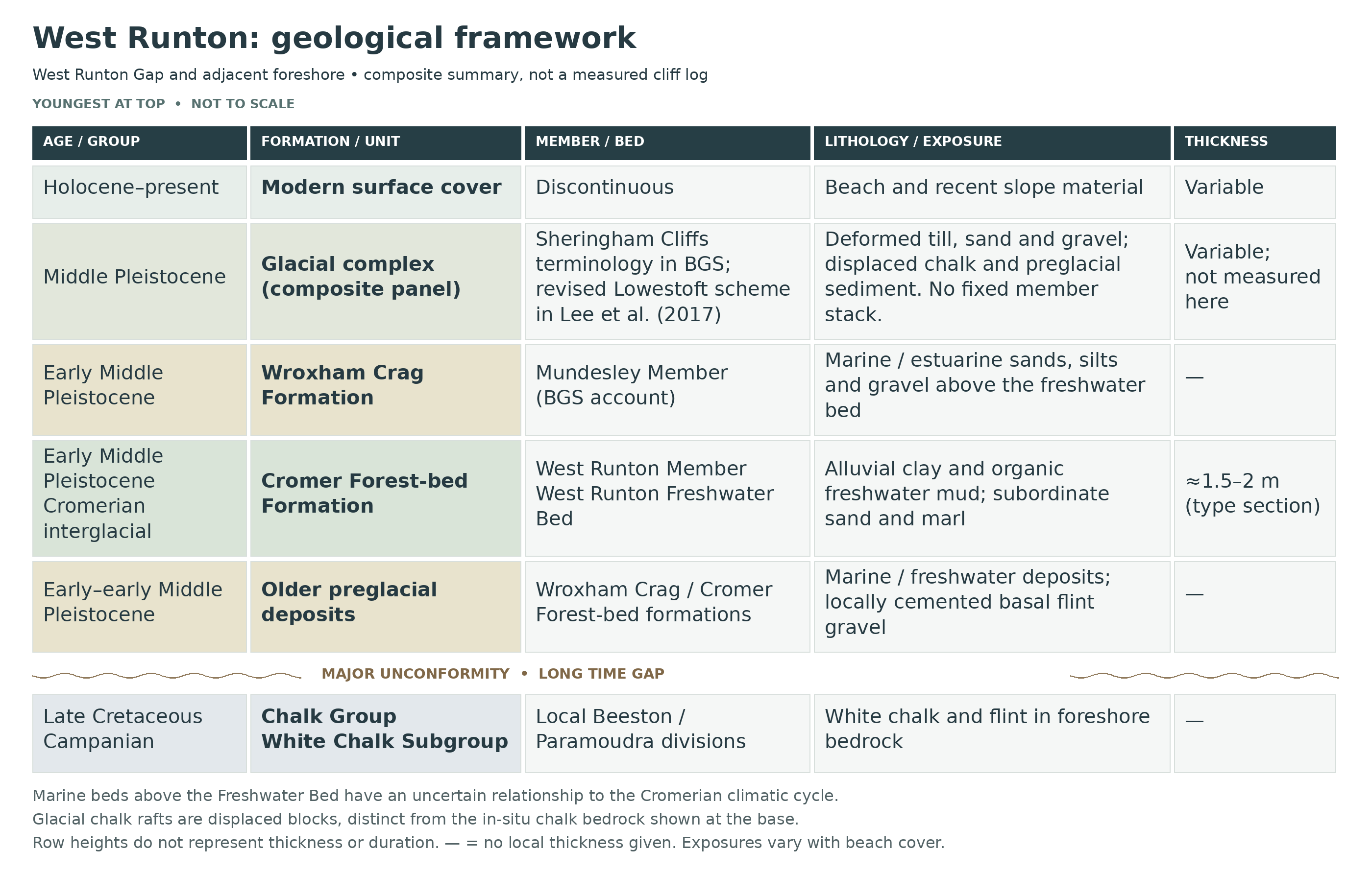
Two geological timescales. The hard white rock on the foreshore belongs to the Upper Cretaceous Chalk Group. Much of its fine carbonate came from microscopic marine organisms; larger shells and skeletons lived in the same sea. The local Campanian succession includes the Beeston and Paramoudra chalk divisions. Flint seams and conspicuous ring-shaped or columnar flints can be visible when the beach is scoured, but these should not all be labelled as individual fossil sponges.
A major erosion surface separates the Chalk from the Pleistocene deposits. Marine and estuarine sands, silts and gravels belong to the Wroxham Crag Formation. Freshwater deposits belong to the Cromer Forest-bed Formation: the two formations interdigitate, reflecting changes between coastal waters and river environments. The name “Forest-bed” does not mean that every dark bed is an intact forest soil, nor does the older term “Weybourne Crag” describe the entire younger succession.
The West Runton Freshwater Bed. This dark, fossil-rich deposit is the local expression of the West Runton Member. It accumulated in a small, spring-influenced river valley during the transition into an early Middle Pleistocene temperate interval. Its pollen, shells and vertebrates make West Runton the reference locality for the Cromerian interglacial in its strict British sense. It is commonly described as approximately 700,000 years old, but its precise correlation with marine isotope stages remains debated; a single exact age would be misleading.
A landscape deformed by ice. Above the preglacial sediments are tills, sands and gravels affected by folding, thrusting and mixing beneath and beside advancing ice. Chalk rafts were detached from the bedrock and lifted into younger deposits. These relationships explain apparently misplaced masses of chalk and sharply contorted bedding towards East Runton. The upper cliffs are a structural complex, not a tidy stack in which every visible band represents a younger undisturbed layer.


Detailed geology and stratigraphy of West Runton.
Local succession and how to read it
The descriptions follow original depositional order from the Chalk upwards. They combine separate documented West Runton exposures, not one continuously exposed cliff log. In the Freshwater Bed, individual sediment bodies vary laterally; in the glacial deposits, folding and thrusting can repeat or invert older material. Measurements belong to the stated historical sections and do not describe what is necessarily visible today.
Chalk Group
The foreshore bedrock is Late Cretaceous chalk. Its large age difference from the overlying Pleistocene sediments is fundamental: white chalk in a high cliff may instead be a much older slab lifted into that position by ice.
White Chalk Subgroup
The locally relevant Upper Campanian divisions are the Beeston and Paramoudra chalk members. They are useful regional subdivisions, but the literature does not establish a complete bed-by-bed chalk log for the beach immediately beside West Runton Gap.
Beeston Chalk Member
Soft white chalk with prominent, irregular flints occurs on the shore westwards towards Beeston. In bedding-plane view, some flints form rings; the original coastal descriptions trace these towards the Runtons. The Catton Sponge Bed defines the regional lower boundary, but that does not make it an exposed West Runton marker or justify importing the Catton Grove quarry log.
Top-Beeston hardground at West Runton
BGS records an indurated horizon on the West Runton foreshore with concentrations of Echinocorys and saurian vertebrae. It is used near the Beeston–Paramoudra division. No secure local thickness or formal bed number is assigned here.
Paramoudra Chalk Member
The overlying local division includes conspicuous cylindrical flints as well as ordinary flint horizons. Microfossil work identifies the incoming Bolivinoides miliaris and Bolivinoides sidestrandensis at or close to its base in a West Runton section. These are microscopic correlation markers, not additional visible beds. The far higher Pyramidata Hardground at Overstrand must not be inserted into a West Runton column.
Chalk–Pleistocene unconformity and basal stone bed
A major erosional break separates the Chalk from flint-rich Pleistocene gravel. At West Runton the basal gravel is locally cemented and can appear on the low-tide shore. It records a lag on an eroded surface, not continuous deposition through the long missing interval.
Crag Group
The marine and estuarine preglacial sediments are distinguished from the freshwater Cromer Forest-bed Formation. Their alternation reflects coastal environmental changes; their names must not be collapsed into a single “Forest Bed”.
Wroxham Crag Formation: older marine deposits
Shelly gravel, sand, silt and clay occur below the Freshwater Bed. The old “Weybourne Crag” terminology applies to an older marine interval, not every marine deposit along the Runton coast. Its fossil and age correlations must remain separate from the younger freshwater mammal fauna.
Paston Member — West Runton Sand and West Runton Clay
BGS places the historically named West Runton Sand and West Runton Clay within the Paston Member. The latter includes about 1.5 m of tidal silty clay in the published account. These names are not synonyms for the younger West Runton Member and its Freshwater Bed.
Dunwich Group
The freshwater Cromer Forest-bed Formation is assigned to the Dunwich Group by the BGS Lexicon. Group membership concerns depositional classification; it does not imply that all of its regional members occur together at West Runton.
Cromer Forest-bed Formation
Freshwater mud, sand and organic sediment record river and pool environments. The formation includes several different climatic episodes along the Norfolk coast. A dark organic layer is not enough by itself to correlate one exposure with the West Runton Freshwater Bed.
Runton Member: older freshwater deposits
The older Runton Member includes the laminated freshwater silty clay historically called Woman Hythe Clay. It is distinct from the West Runton Member. The BGS Lexicon gives no thickness for this member, so no local metre figure or complete Beeston type-section log is transferred here.
West Runton Member — West Runton Freshwater Bed
The type member comprises alluvial clay and organic freshwater mud, commonly quoted as about 1.5–2 m thick. Its dark fossiliferous sediments are the reference deposit for the Cromerian interglacial in the strict British usage. That summary thickness is not a constant across the channel and must not replace measurements from a named research profile.
Six measured sedimentary units
The following i–vi descriptions use the 1995 mammoth-excavation account. Thicknesses are local; boundaries and facies vary laterally.
Unit i — basal silt
About 30 cm of fragmented dark silt contains pale silt pellets, wood and broken shells; it overlies irregular sand and gravel.
Unit ii — shell-rich silt
Approximately 50 cm of brown silt contains chalk, silt, wood and abundant shell debris. A separate fossiliferous sand, 30 cm locally, overlies it.
Unit iii — sandy organic silt
A sharp contact introduces roughly 15 cm of very dark, fossiliferous sandy silt above the intervening sand.
Unit iv — sandy to stratified silt
Around 60 cm of sandy grey silt with sand laminae passes into darker fossiliferous, finely stratified silt.
Unit v — mottled clay
The preceding silt grades into mottled grey-brown clay with oxidised patches. No separate thickness is stated for this excavation interval.
Unit vi — iron-cemented upper silt
Approximately 18 cm of hardened clayey silt has a bored upper surface; gravel-filled holes sometimes contain Mya in life position.
Relationship to West’s lettered beds
Tentative published equivalence: a–c ≈ i; d ≈ ii; e ≈ iii; f–g ≈ iv–vi. These are overlapping schemes, not thirteen successive beds.
Fossils and environmental interpretation
The freshwater assemblage includes small-mammal teeth, fish remains, molluscs and plant material. Mammoth-associated samples preserve a diverse temperate fauna; the presence of Mimomys savini is important for comparison with later deposits containing Arvicola. Species lists compiled for the whole Freshwater Bed should not be assigned to every numbered unit without sample-level evidence.
Upper erosion surface and “Monkey Gravel”
The gravel immediately above the Freshwater Bed represents renewed marine influence. Historic macaque material comes from this higher gravel, not securely from the underlying freshwater fauna. The gravel and tidal deposits above it are separate from the six freshwater units, even where their sediment enters holes in the hardened upper surface.
Crag Group — renewed marine deposition
The younger marine interval returns to the Crag Group; it is not part of the Dunwich Group freshwater succession.
Wroxham Crag Formation: younger marine return
Marine sedimentation resumed above the freshwater interval. This is a second occurrence of the formation in the composite succession, reflecting alternation of marine and freshwater environments, not a new formation with a similar name.
Mundesley Member: marine sands and silts
BGS includes the historical Yoldia/Leda Myalis Bed at West Runton in this member. The marine shell-bearing beds are younger than the Freshwater Bed, but their exact relationship to the Cromerian vegetation cycle remains debated; cold-water molluscs may indicate a subsequent cold interval. A regional Mundesley thickness is not a West Runton measurement.
Albion Glacigenic Group
The glacial deposits must be read structurally as well as stratigraphically. Younger ice movement folded, sheared and incorporated pre-existing sediments and chalk rafts. The following local lithological units do not imply an undisturbed horizontal stack.
Sheringham Cliffs Formation: BGS Lexicon framework
The coastal type area extends between West Runton and Sheringham. The BGS framework distinguishes Runton and Bacton Green tills and basin-forming sand and gravel. Later research reorganises some of the same disturbed material; the alternative framework is explained separately below.
Runton Till Member
Dark grey to brownish diamicton contains stretched sand and chalk lenses and fragments of older chalk-rich till. Its lower contact with marine Crag is sharp and can be a detachment; the upper boundary grades towards stratified Bacton Green Till. The published maximum of 9 m belongs to the type section towards Beeston Hill, not to every West Runton cliff face.
Bacton Green Till Member
Stony diamicton alternates with sorted sand, silt and clay. The stratification is interpreted as deposition involving melt-out and sediment flows into water, subsequently modified by deformation. The regional 10–15 m range is not a secure local thickness at the Freshwater Bed exposure. Its upper surface is commonly truncated rather than continuously conformable.
Runton Cliffs Sand and Gravel Member
Yellowish to brown sands show channels, ripples and cross-bedding, with gravel beds. The lower contact is scoured and the deposit occupies pronounced basins in underlying till. Its BGS type section at Beeston Cliffs, adjoining West Runton, records up to 10 m. This figure is a type-section value; it should not be added to the other regional maxima to create a fictitious total cliff height.
Lowestoft Formation — alternative 2017 structural framework
The following names belong to the alternative scheme of Lee and colleagues (2017). They reclassify parts of the same disturbed glacial complex described above; they are not an additional sequence deposited on top of the BGS Lexicon succession.
West Runton Melange Member — alternative scheme
The type exposure is at West Runton Cliffs, TG 181433. It combines intensely deformed earlier tills, preglacial sediment, marl and occasional chalk rafts. The authors report a maximum observed thickness of 25 m in their summary. Its boundaries reflect shearing and mixing rather than a single undisturbed depositional bed.
Runton Sand and Gravel Member — alternative scheme
The West Runton Cliffs stratotype, TG 180432, contains stratified sand and gravel in basins formed within the mélange. Sharp margins are commonly down-faulted; the paper reports a maximum observed thickness of 12 m. This name and figure belong to the 2017 scheme, whereas the BGS Lexicon entry uses Runton Cliffs Sand and Gravel Member and a different type-section summary.
References
Gibbard, Boreham, Andrews and Maher (2010). Sedimentation, geochemistry and palaeomagnetism of the West Runton Freshwater Bed. Quaternary International 228, 8–20; especially sections 2–3 and figures 3–7.
BGS. Cromer district, Sheet 131: coastal Crag and Chalk descriptions.
BGS. Upper Cretaceous Chalk stratigraphic framework, RR/05/01.
BGS Lexicon. Cromer Forest-bed Formation and its parent Dunwich Group.
BGS Lexicon. West Runton Member.
BGS Lexicon. Runton Member.
BGS Lexicon. Runton Till Member.
BGS Lexicon. Bacton Green Till Member.
BGS Lexicon. Runton Cliffs Sand and Gravel Member.
Lee and colleagues (2017). The Middle Pleistocene glacial evolution of northern East Anglia.
Preece and colleagues (2020). The palaeontology and dating of the Weybourne Crag.
Mortimore, Wood and Gallois (2001). GCR account of Catton Grove, including the West Runton microfossil boundary comparison.
SAFETY
Visit on a falling tide and allow a generous margin for returning. Offshore chalk platforms, pools and projections of the cliff can become isolated as water rises; wind and waves may reduce the usable beach before the predicted high tide. Do not round an obstacle unless the whole return route will remain open.
The soft cliffs can collapse without warning, particularly after rain, frost or storms. Stay away from their base and edge, do not climb slips or approach an overhang, and never use the cliff as an alternative exit. Recent erosion may reveal fossils while simultaneously making a visit more dangerous. Slippery chalk, seaweed, uneven flints and deep soft mud require care; children need close supervision.
EQUIPMENT
Take tide information, a charged phone, sturdy footwear with a good grip, a hand lens, a camera and small rigid specimen boxes. Soft wrapping and labels are more useful than heavy tools. A hammer or pick is unnecessary for the recommended loose-beach search and must not be used to excavate protected exposures without the appropriate permissions.
CLEANING AND TREATING
Keep fragile bone and teeth supported with their surrounding sediment. Do not scrub freshly exposed bone, prise apart a jaw or wash fine freshwater shells out of soft mud. Photograph each specimen before cleaning. Waterlogged wood and very soft organic material require prompt specialist advice; allowing them to dry out can cause irreversible shrinkage or cracking.
Stable chalk or flint specimens can be allowed to dry slowly and cleaned initially with a soft brush. Only use gentle fresh-water cleaning after confirming that the fossil and its matrix are sound; avoid prolonged soaking of crumbly chalk, bone or cracked teeth. Never use acids, bleach or a wire brush. Leave scientifically important material unprepared. If weak bone genuinely needs consolidation, a conservator can select a reversible treatment such as Paraloid B-72; routine varnishing or indiscriminate gluing can obscure evidence.
Identify your finds
Need help identifying a fossil? Share clear photos, where you found it and its size with the community.
FURTHER READING
Deposits Magazine: fossil voles as stratigraphic aids
Deposits Magazine: Locations in the Norfolk area — a personal view
BGS: West Runton Member
The West Runton Freshwater Bed: field guide
West Runton Freshwater Bed: faunal records and primary references
Norfolk Heritage Explorer: West Runton Mammoth
Natural England: West Runton Cliffs SSSI citation
Norfolk Museums and North Norfolk Council: responsible fossil collecting
ACCESS RIGHTS
The principal fossil exposure is within West Runton Cliffs SSSI. Its designation protects an internationally important geological sequence; public access to the shore does not confer permission to excavate or remove material from the protected beds. Follow current Norfolk Museums and council guidance: concentrate on loose beach finds, respect ownership and obtain the appropriate landowner and Natural England permissions before any excavation. Check local signs and temporary access restrictions, and seek advice before attempting to recover a significant specimen.
It is important to follow our ‘Code of Conduct’ when collecting fossils or visiting any site. Please also read our ‘Terms and Conditions‘
LINKS
♦ Fossil Discussions
♦ Fossil Articles
♦ Buy Fossils, Tools and Equipment
♦ Buy Crystals, Meteorites, and Artefacts
♦ Join Fossil Hunts
♦ UK Fossils Network