Weybourne brings together Cretaceous Chalk, shell-rich Early Pleistocene sediments and glacial deposits in a compact but changeable coastal section. Belemnites and sea urchins occur in the chalk, while the overlying Wroxham Crag preserves marine shells and much smaller traces of land mammals washed into an ancient sea. The contrast makes this a rewarding place to study different fossil communities and the long gaps between them. Collecting is best approached as a patient search of loose beach material: the steep shingle shore, tides and unstable cliffs make access demanding, and high ledges must be left alone.


FIND FREQUENCY: ♦♦♦ – Chalk and Crag fossils may occur in loose material, but exposure and preservation vary.
CHILDREN: ♦ – The extended collecting walk is demanding, with steep shingle, tides and unstable cliffs.
ACCESS: ♦♦ – Beach Road parking is convenient, but walking east along deep shingle is tiring.
TYPE: Coastal cliffs and loose beach material; Chalk beneath shelly Crag and glacial deposits.
DIRECTIONS
♦ From the A149 in Weybourne, follow Beach Road to the council beach car park, NR25 7SR. The shore is reached at Weybourne Hope; turn east for the cliff section. Stay on the open beach and use only established access points. Do not follow old instructions to descend arbitrary cliff slopes or climb onto chalk shelves. Allow plenty of time for the return over shingle.
♦ What3Words collecting area: ///mixed.landlady.sobered
FOSSIL HUNTING
Search loose chalk fragments, weathered beach stones and naturally released fossils while keeping clear of the cliff. Chalk and flint fossils are Cretaceous, whereas shells and small bones from the Crag belong to a much younger deposit. A worn fossil loose on the beach may have been moved more than once, so record the matrix and exact find position rather than assigning it to the nearest visible layer.
Belemnites of Belemnitella, including local records of Belemnitella mucronata, are useful targets in chalk material. Echinoids of Echinocorys, oyster shells, brachiopods and isolated sea-urchin spines also occur. Complete echinoid tests are easily damaged and many are already crushed. The older collecting account names Cretirhynchia limbata and Tylocidaris clavigera; treat names on old collections as identifications to check, rather than assuming every similar shell or spine belongs to those species.
The Crag’s marine molluscs include the small bivalve recorded in the geological literature as Macoma balthica. Scientific samples from Weybourne Hope and the section nearby have also yielded tiny teeth of Mimomys pliocaenicus, Mimomys tigliensis, Mimomys reidi and Borsodia newtoni. These are microscope-scale research finds, usually recovered by careful sediment processing; they should not be advertised as conspicuous fossils routinely lying on the beach.
Larger mammal remains are occasional rather than guaranteed. A documented Weybourne specimen in the Jonathan Stewart collection is a mammoth toe bone, identified only as Mammuthus sp. Keep important bones and their fragments together, photograph their context and ask a museum for advice. Do not dig a shell bed, cut footholds, climb ledges or take bulk sediment samples without the appropriate permission.


A chronological record of significant geological research and discoveries at Weybourne.
1882 – Weybourne Crag named at its type locality
Clement Reid used the name for the shallow-marine shelly sands and associated laminated clay above the Chalk at Weybourne Hope. The term became central to comparisons of Norfolk’s pre-glacial deposits.
1964 – Weybourne Cliffs recognised for conservation
The cliff section was notified as a Site of Special Scientific Interest, recognising its nationally important Pleistocene exposures.
1985 – Protected cliff section extended
Renotification incorporated the former Skelding Hill Cliffs site and the intervening stretch, bringing the connected geological section within the protected area.
1990 – Chalk exposures correlated in detail
Andrew Pitchford’s work on the Belemnitella mucronata Zone described the Weybourne coastal chalk and clarified its relationship to marker beds and other Norfolk sections.
1998 – Small mammals and pollen studied together
David Mayhew and Philip Gibbard described tiny mammal remains and associated pollen from Weybourne Hope, providing evidence for the age and environment of the Crag.
2004 – Glacial deformation reconstructed
Steven Pawley and colleagues investigated the Weybourne cliff sediments, interpreting the mixing of sandy and chalk-rich tills and the preservation of meltwater deposits in sag basins.
2020 – The Weybourne Crag’s age reassessed
Richard Preece and colleagues brought together fossil and amino-acid evidence, including material from the type locality. Their correlations indicated an older Early Pleistocene age than some previous estimates and cautioned that all Weybourne Crag sites need not be exactly contemporary.
GEOLOGY
The lower cliff and occasional foreshore exposures show the Campanian Weybourne Chalk, part of the White Chalk Subgroup. It contains flint bands and changes from softer chalk to harder, nodular beds. Its fossils lived in a Cretaceous sea, long before the shell-bearing Crag was deposited. The chalk surface was eroded before the younger sediments accumulated, leaving a major unconformity.
The Wroxham Crag Formation contains shallow-marine sands, gravels and shells. “Weybourne Crag” remains a useful historical name for the shell-bearing interval at its type locality, but is not simply a replacement name for every part of the wider Wroxham Crag Formation. Modern studies of its mammals and molluscs have revised the age and correlation of these deposits; the old Pastonian terminology does not provide a simple date for every coastal bed.
Above lie glacial tills and meltwater deposits. Ice compressed, sheared and mixed the tills, while sand and gravel survive in irregular basins. This is not an undisturbed stack of flat, continuous beds. Slumping and beach movement further alter what is visible, so the order seen in one small cliff face cannot safely be projected along the whole shore.


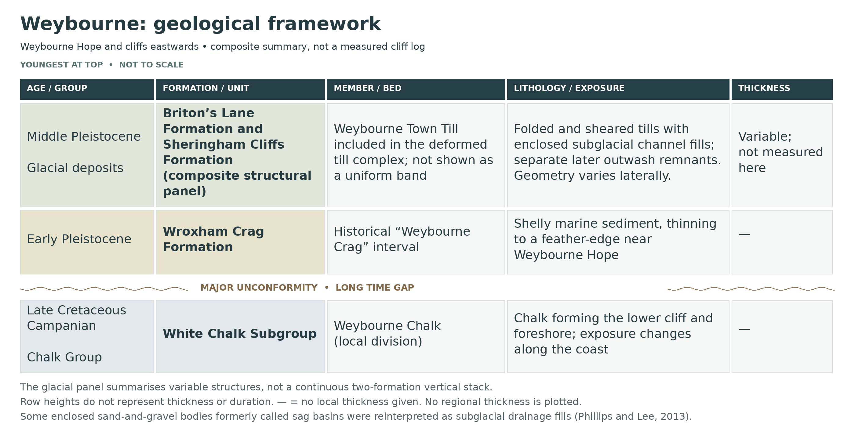
Detailed geology and stratigraphy of Weybourne.
This is an idealised youngest-to-oldest account of Weybourne Hope and the cliffs eastwards. Glacial deformation, erosion and lateral changes prevent it from being treated as a single continuously exposed measured column.
Glacial and meltwater deposits
ALBION GLACIGENIC GROUP
Briton’s Lane Formation
Briton’s Lane Sand and Gravel Member
Later coarse-grained outwash survives as erosive remnants rather than as a continuous cap. Stratification and the mixed clast assemblage distinguish water-laid sediment from the underlying diamicton. Pawley and colleagues correlated outwash with the Briton’s Lane sand and gravel using sedimentary evidence and Scandinavian-derived clasts. Later work distinguished this outwash from channel bodies enclosed within the older deformed till. Basin geometry and deformation complicate the contact, so regional maximum thicknesses are not assigned to individual coastal exposures.
Sheringham Cliffs Formation
Sand-and-gravel bodies were historically described as outwash in large sag basins. The mapped 2013 study identifies a different origin for some bodies: subglacial drainage fills within the deformed till, distinct from later outwash. The till succession includes a chalk-rich Weybourne Town Till and sandy material incorporated into it during shearing. Published interpretations and terminology for the older sandy till have evolved; the important field observation is the mixing and repetition, rather than an apparently tidy succession of separate flat sheets.
The Weybourne Town Till is a member of the Sheringham Cliffs Formation. Its type section is the inland Weybourne Town Pit, a different site from this coastal guide. Neither the pit’s measurements nor the formation’s regional maximum thickness is used as the height of the coastal unit.
Weybourne Town Till Member: chalk-rich diamicton
The chalk-rich component is a highly calcareous, consolidated diamicton: clasts are dispersed in a finer matrix rather than sorted into ordinary gravel beds. It can be strongly banded, incorporating stretched and folded pieces of pre-existing sandy till. Its base can be a sharp shear or detachment surface against older sediment. The BGS definition permits contacts on Crag or older till, so a visible chalky band need not mark a new glacial advance each time it is repeated. “Marly Drift” is a historical term; it does not make this deposit a marine marl.
Sandy till components: Runton and Bacton Green correlations
Pawley and colleagues’ coastal study described a lower sandy Runton Till incorporated into the overlying chalk-rich till. The wider 2004 stratigraphy recognises sheared inclusions assigned to both Runton Till and Bacton Green Till in the Weybourne area. These sandy components and their attenuated folds must be described separately from the chalk-rich host, but they cannot be reconstructed as two intact, everywhere-present layers below it. The inland Town Pit has its own thrust-stacked geometry and is not used as a substitute for this cliff section.
Lowestoft Formation — alternative 2017 framework
West Runton Mélange Member — alternative framework
Weybourne Diamicton Member — alternative framework
The later tectonostratigraphical treatment by Lee and colleagues uses Weybourne Diamicton Member for the chalk-rich unit and West Runton Mélange Member for intensely deformed mixed sediment. West of Sheringham, that mélange incorporates interfolded chalk-rich diamicton as well as older material. These names reflect a revised structural interpretation and are not extra units to insert above the BGS till members. The section here retains BGS Lexicon names for the principal hierarchy while identifying the later usage, because bed order has been changed by ice-driven shearing and thrusting.
Return to the mapped coastal units and BGS lithostratigraphical framework. The following channel-fill descriptions are lithofacies within the deformed complex, not additional members assigned beneath the alternative Lowestoft heading.
Thicknesses in the mapped coastal study. Phillips and Lee’s 4.4 km Sheringham–Weybourne section records an upper Weybourne Town Till around 1–2 m thick, Bacton Green mélange locally up to 30 m, preserved Happisburgh Till up to 10 m, and Wroxham Crag about 1–5 m thick. These are observations across the mapped coastal section, not inland-pit measurements; they do not define one cumulative column or the thickness at Weybourne Hope. Erosion and structural repetition account for substantial local variation.
Subglacial sand-and-gravel channels: a revised interpretation
The detailed Sheringham–Weybourne mapping by Phillips and Lee separates sand-and-gravel bodies enclosed in the till mélange from later Briton’s Lane outwash. Concave erosional bases, locally preserved till caps and deformation shared with the enclosing diamicton indicate that the enclosed bodies formed during subglacial activity. The authors reject a purely gravitational “sag basin” origin for the bodies they studied. This revises the interpretation of particular exposures rather than demonstrating that all basins along the Norfolk coast formed in the same way.
Channel-fill facies and water-escape features
The mapped fills comprise coarse gravel packages, graded gravel-to-sand beds, cross-bedded or ripple-laminated sand, and local silt, clay and mass-flow layers. Cross-cutting packages record repeated shifts in meltwater flow rather than one continuous deposit. At TG 13458 43555 in the eastern Weybourne coastal section, folding and thrusting at a channel margin are cut by a 2–5 m wide steep water-escape conduit containing red-brown sand, interpreted as derived from underlying Crag. That width is a structural measurement of one feature, not the thickness of a named sedimentary bed.
Happisburgh Glacigenic Formation
Happisburgh Till Member: locally preserved below the mélange
The same western-coast study documents an older grey, relatively clay-rich till beneath the sandy mélange where preserved. It thins westwards and is ultimately cut out between the younger deformed sediment and the Chalk. Its discontinuous occurrence is important: it should neither be omitted from the documented coastal context nor drawn as a continuous basal member at Weybourne Hope. The full east-Norfolk succession, including Walcott Till and eastern lake beds, is not imported into this western section.
CRAG GROUP
Wroxham Crag Formation
Shelly sand, gravel and locally laminated finer sediment rest above the eroded Chalk. At Weybourne Hope the historical Weybourne Crag wedges out; farther east the succession becomes thicker and more varied. Marine shells occur with terrestrial material transported into the sea, so a land-mammal tooth does not make the enclosing bed a terrestrial soil or river deposit.
Modern fossil and amino-acid research places the named Weybourne Crag interval in the Early Pleistocene and supports correlation around 2.1–2.2 million years ago, with uncertainty in the exact equivalence of separate sites. This estimate should not be applied to every Wroxham Crag bed or to the overlying glacial deposits. Laminated and reworked silty material adds environmental complexity; the local succession is not labelled wholesale as the West Runton Freshwater Bed.
Upper laminated and reworked fine sediment towards Skelding Hill
Eastwards towards Skelding Hill, the pre-glacial succession includes laminated silty clay as well as sand and gravel. Published sections reach about 4 m in total, whereas the deposits thin sharply towards Weybourne Hope. Pollen from fine-grained material has been used to distinguish cold and cooler-temperate vegetation. At Skelding Hill the laminated clay above the historical Weybourne Crag was assigned to the Pastonian and has a reversed palaeomagnetic signal. These are lateral-section observations, not a claim that the entire 4 m sequence stands above every collecting point.
Shelly sands and gravels: the historical Weybourne Crag
The type-locality interval consists of shallow-marine shelly sand with laminated clay. Gravel includes rounded flint and far-travelled quartzose material, reflecting river supply to the coast. The marine fauna and the association of Macoma balthica with Mya arenaria have long been useful for correlation. Vole teeth, including Mimomys and Borsodia, supply additional age evidence. These land-derived remains occur in marine sediment and do not establish a separate freshwater bed wherever a tooth is found.
Clay-pebble and iron-cemented concentrations
Local erosion of fine-grained sediment produced clay clasts and conglomeratic concentrations within the cross-bedded sands. Grey silt clasts at Weybourne Hope contain pollen spectra and may have been reworked from laminated deposits like those farther east. Iron cement locally binds sand, gravel and fossil material, creating harder ledges. Such features should be recorded as local facies and reworking horizons; “iron pan” is a useful field description, not a separately established formation with a fixed coastwide age or thickness.
Mundesley Member: a mapping correlation, not a second shell bed
BGS mapping and the Weybourne slope study have included the coastal Crag in the marine Mundesley Member of the Wroxham Crag Formation. The historical name Weybourne Crag and this member assignment arise from different stratigraphical schemes and are not two successive deposits. Modern biostratigraphical work focuses on the older shell-bearing interval at the type locality; its approximate 2.1–2.2 Ma correlation must not be extended automatically to every sediment that older mapping grouped into the marine member. Nor is this marine Mundesley Member the glacial Mundesley Sand Member.
Basal erosion surface and soliflucted Chalk residue
The Crag rests unconformably on an uneven Chalk surface. Locally a thin chalk-rich residue, containing broken flint and chalk in a finer matrix, separates solid Chalk from shelly sand and gravel; it has been interpreted as pre-Crag solifluction material. Later dissolution, cryoturbation and glacial erosion also modified the junction. The order of processes matters: the brecciated chalky residue is not automatically a till laid down by the same ice that formed the higher glacial succession.
CHALK GROUP
WHITE CHALK SUBGROUP
Weybourne Chalk Member
The Campanian chalk is flinty, with softer lower beds and harder, nodular chalk above. The stratotype includes sections at Weybourne Hope and Weybourne Hope East. Published estimates of roughly 22–25 m describe the stratigraphical unit assembled across exposures, not a single cliff face of that height. Oysters are conspicuous in part of the succession, and upper omission surfaces lead towards the Catton Sponge Bed marker.
The eroded top separates the Chalk from the Crag across an enormous time gap. Modern sand and shingle may hide both units; loose fossils on the present beach can therefore be mixed even where their source strata are distinct.
Upper Weybourne Chalk and the Catton Sponge Bed boundary
At Weybourne Hope East the upper chalk alternates between harder and softer flinty intervals and contains two omission surfaces. The top of the Weybourne Chalk is defined in the regional scheme at the upper surface of Hardground II of the Catton Sponge Bed. The BGS Cromer account identifies the correlated Catton Sponge Bed as the lowest of three sponge-bearing horizons on the Sheringham foreshore, farther east. The paired marker is therefore essential to defining the unit, but the Catton Grove quarry log and its labelled flints are not imported as a measured Weybourne cliff section.
Weybourne 3, Weybourne 2 and Weybourne 1 faunal belts
Three informal, poorly delimited faunal belts have been recognised, numbered upwards from Weybourne 1 to Weybourne 3. In descending order, the upper belt approaches the hardground-bearing top; the middle belt is notably oyster-rich; and the lower belt occurs in the generally softer flinty chalk. These are palaeontological subdivisions, not sharply bounded formal members. The middle and upper chalk become harder and more nodular, with persistent flint bands. The available published summaries do not justify assigning a separate numerical thickness to each belt at the beach.
Oyster-rich middle chalk and hardground
In the stratotype succession, the middle chalk contains conspicuous oysters, including Pycnodonte and Hyotissa, together with a hardground. BGS regional synthesis gives a thickness of up to about 0.5 m for that hardground in the described succession; it is not a measurement of all oyster-bearing chalk or a guarantee of exposure at Weybourne Hope on a particular visit. A hardground records seabed cementation and interrupted sedimentation, rather than a volcanic or terrestrial rock layer.
Basal marker: Flint X and the underlying hardground
Published schemes have placed the base at Flint X or at an underlying hardground. Another BGS framework describes a sponge-bed hardground above Flint Z in the Weybourne Hope section. These definitions should remain tied to their original logs and not be collapsed into a newly invented composite “Flint X–Z Bed”. They show why a local flint band or a change in hardness alone may be insufficient to correlate an isolated exposure. The broad unit lies in the Late Campanian Belemnitella mucronata sensu lato succession; more finely divided belemnite schemes use additional names.
Pre-Weybourne Chalk beneath the named unit
The Cromer sheet explanation records about 5.4 m of older, Pre-Weybourne Chalk in the coastal succession eastwards from Weybourne Hope. This is additional to, not part of the quoted 22–25 m Weybourne Chalk estimate. The older chalk provides the lower side of the basal marker discussed above. Inland subdivisions such as Eaton Chalk and Basal Mucronata Chalk should not be assigned complete thicknesses here without the corresponding local log.
Glacial shearing of the chalk at Weybourne Hope
Close to the western end of the cliff section, low-angle shear planes displace flints and fossils within the Chalk. The nodular and broken appearance can therefore reflect deformation as well as original bedding and later dissolution. Sheared fossil fragments still belong to Cretaceous bedrock, but their displacement must be considered when following a horizon laterally. This structural modification is distinct from the younger till resting above the Crag.
References
BGS Lexicon: Wroxham Crag Formation
BGS Lexicon: Weybourne Town Till Member
BGS Lexicon: Sheringham Cliffs Formation
Weybourne Cliffs SSSI citation
Preece and colleagues (2020), The palaeontology and dating of the Weybourne Crag
Pawley and colleagues (2004), Middle Pleistocene sedimentology and lithostratigraphy of Weybourne
BGS Cromer district sheet explanation: Pre-Weybourne and Weybourne coastal Chalk
BGS synthesis: Weybourne Chalk and its marker definitions
Hopson (2005), Chalk framework: alternative basal-marker terminology
BGS East Anglia regional geology
Lee and colleagues (2004), revised glacial lithostratigraphy
Lee and colleagues (2017), tectonostratigraphical framework
BGS slope dynamics report: Weybourne case study
SAFETY
The shingle can be steep, loose and exhausting to walk across, particularly with a heavy bag. Allow more time than the distance on a map suggests, and avoid strong onshore winds and breaking waves. Use a falling tide and return before water restricts the beach against the cliffs.
Stay well away from the cliff base, overhangs and fresh falls. Never climb the chalk ledges or iron-cemented Crag, use abandoned ladders or cut steps into the exposure. Rain-softened sediment can fail without warning, and nesting birds add another reason to leave the cliff face undisturbed.
EQUIPMENT
Wear supportive footwear suitable for loose shingle, and carry tide information, water, a phone, a hand lens and well-padded boxes. Keep the load light enough for the return walk. Small labels are valuable for separating Chalk fossils from Crag material. A pick or climbing equipment is inappropriate for this visit; any research sediment sampling needs prior permission.
CLEANING AND TREATING
Support fragile echinoids in a rigid box before transport and avoid pulling a thin test away from its chalk filling. Begin with soft dry brushing. On sound chalk specimens, a little water may help remove surface dirt, but test a small area first and stop if the surface softens. Iron-cemented Crag can hold delicate shells firmly; leave matrix rather than forcing it off.
Do not soak crumbly shells or porous bone, bleach them or coat them with varnish. Let wet specimens dry slowly while supported. Seek specialist advice on significant bone or microvertebrate material before preparation; careful labelling and preservation of associated sediment can be more valuable than a cosmetically cleaned surface.
Identify your finds
Need help identifying a fossil? Share clear photos, where you found it and its size with the community.
FURTHER READING
Deposits: Locations in the Norfolk area, including Weybourne
Deposits: Small is beautiful, fossil voles as stratigraphic aids
Deposits: Belemnites, including Weybourne specimens
BGS: Weybourne Chalk
Weybourne Crag palaeontology and dating, Preece and colleagues (2020)
Weybourne’s glacial sediments, Pawley and colleagues (2004)
North Norfolk field guide: Weybourne
ACCESS RIGHTS
The cliffs east of Weybourne form Weybourne Cliffs SSSI, important for Pleistocene strata and fossils as well as nesting birds. Follow the current North Norfolk collecting guidance: collect loose beach finds, and do not dig into cliffs without appropriate permissions. Public access does not authorise bulk sampling or damage to the exposure. Ask the landowner and relevant conservation bodies before organised sampling, and report significant finds with accurate locality records.
It is important to follow our ‘Code of Conduct’ when collecting fossils or visiting any site. Please also read our ‘Terms and Conditions‘
LINKS
♦ Fossil Discussions
♦ Fossil Articles
♦ Buy Fossils, Tools and Equipment
♦ Buy Crystals, Meteorites, and Artefacts
♦ Join Fossil Hunts
♦ UK Fossils Network