

Whitehaven’s northern coast preserves Carboniferous plant fossils beneath the Countess Pit Sandstone. Access update, October 2026: foreshore access has been reported closed. The precise extent of the restriction and any reopening remain unconfirmed. Do not rely on the former tunnel-access directions or enter closed areas; confirm current authorised access with Cumberland Council before planning a collecting visit.


FIND FREQUENCY: ♦♦♦♦♦ – The original guide rated plant finds highly, and published field visits record several plant genera. Vegetation, rockfalls and changing beach cover can hide the old exposures; no find is guaranteed.
CHILDREN: ♦ – Do not plan a children’s collecting visit while reported foreshore restrictions remain unresolved. Cliffs, railway property and tidal retreat also present hazards.
ACCESS: ♦ – Foreshore access was reported closed in October 2026. The exact extent and any reopening have not been confirmed; check with Cumberland Council before planning a visit.
TYPE: – Historical cliff exposures and loose foreshore material. The cliff faces and in-situ deposits must not be hammered.
DIRECTIONS
♦ Access update, October 2026: foreshore access at Whitehaven has been reported closed. The precise extent of the restriction and any reopening remain unconfirmed. Check current authorised access with Cumberland Council before planning a collecting visit; the orientation below is not a confirmed route onto the shore.
♦ From the north side of Whitehaven harbour, the historical geological area extends towards the railway station and Parton. Use only open signed public routes and public parking according to current signs. The old supermarket approach does not grant permission to park in customer spaces or cross private working yards.
♦ Follow the open public route north beside the railway. The first prominent red or purple sandstone cliffs belong to a different unit from the grey plant-bearing beds farther north. Keep to the public path around business premises and do not enter old quarry faces.
♦ The historical plant section lies around NX 977 199, north of Redness Point. The original guide’s locality marker is 54.57003°N, 3.58400°W. These identify the geological area, not a guaranteed open entrance to a collecting bed.
♦ Do not rely on the former tunnel-access directions. Historical engineering reports record undermining of an access-tunnel floor, and the present condition of the shore entry is unverified. Never cross the tracks, bypass a barrier, climb scree or descend a cliff to reach the fossil beds.
♦ The readily described beach immediately north of the harbour is not the same as the farther-north plant exposure. If the plant section or shore access is closed, obscured or unsafe, remain on the open public route rather than seeking a shortcut.
DOWNLOAD THE UKF BOOKLET TO FOSSIL HUNTING AT WHITEHAVEN
FOSSIL HUNTING
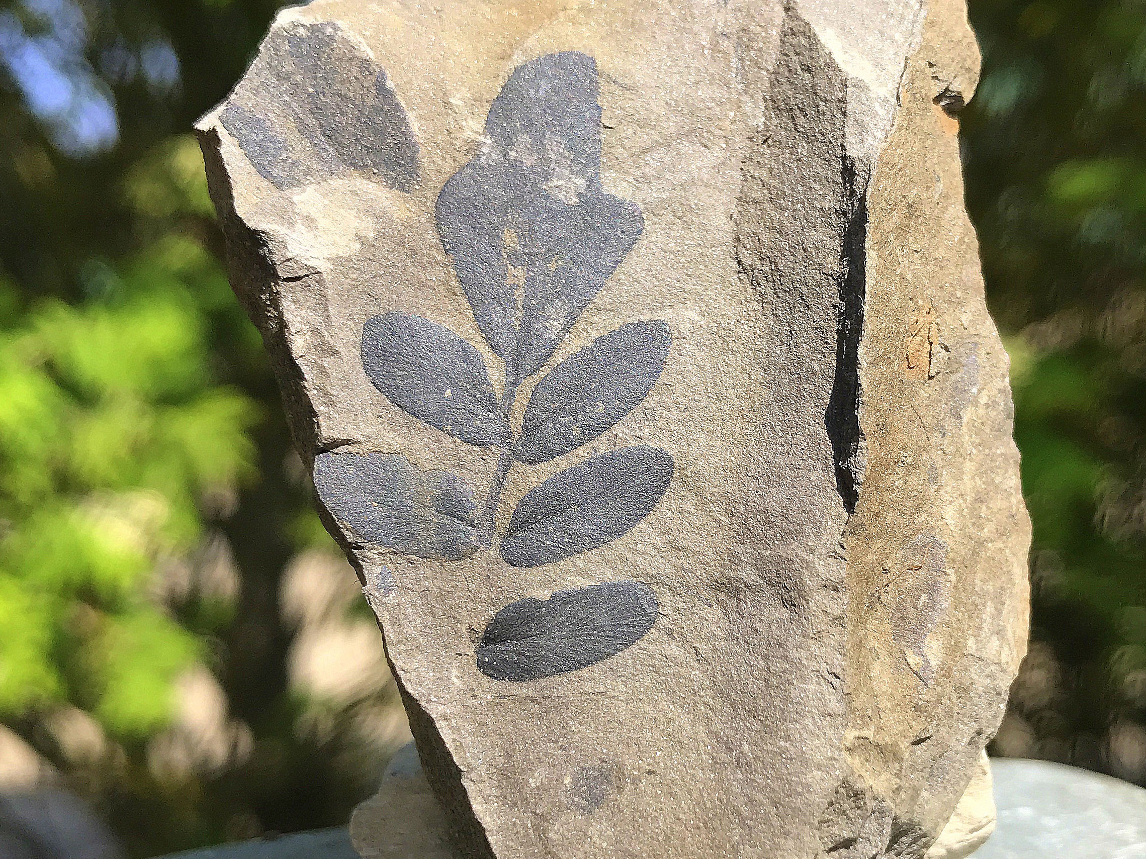
Whitehaven’s best-documented coastal plant bed is a grey, micaceous siltstone beneath the Countess Pit Sandstone. Published visits recorded Calamites, Annularia, Asterophyllites and Neuropteris in historical usage. Similar remains may occur in loose fallen or wave-worked pieces, but their original bed position is uncertain once they have moved.
Calamites stems belonged to relatives of horsetails. Annularia and Asterophyllites are names used for leafy shoots associated with this group, rather than necessarily separate whole-plant species. Neuropterid foliage includes seed ferns. Ribbed stems, leaf whorls and fine branching impressions are useful features to photograph with a scale.
Not all plant material grew where it is now preserved. The published section includes a scoured river-channel base, coaly fragments, ironstone nodules and displaced sediment blocks. These record erosion and transport as well as burial. A detached leaf or stem should not be described as an upright fossil forest, and the old broad species tally cannot be treated as a modern list for every beach stone.
Arber’s 1903 study provides a valuable historical catalogue of coastal specimens, including material collected by Adam Sedgwick. The detailed geology section retains the individual records, their museum numbers and locality limits. Those old organ and form names have not all been checked against the original specimens, and some have changed in modern taxonomy.
On an authorised visit, examine loose surfaces from a secure position well away from cliff toes, overhangs and unstable scree. Fine impressions can be difficult to see on wet, weathered or uneven shale. Photograph uncertain finds, keep matching counterparts together and record whether a specimen came from loose shore material rather than a known bed.
Do not hammer the cliff face or in-situ deposits. The historical reports describe scientifically important beds, not a route to safe excavation. Do not climb to the hard sandstone base, pull material from an overhang or break ironstone nodules out of a face. Where collecting permission is unclear, ask the landowner before removing a loose find.


Significant discoveries, geological research and conservation milestones at Whitehaven.
1729 – Early plant remains are recorded at Bransty
John Woodward published 24 plant remains reported from a depth of 25 fathoms at Bransty near the Duke of Somerset’s salt pans. These were specimens, not 24 species. Their uncertain mine and horizon meant they were not later used as secure age evidence for the coastal beds.
1830s – Sedgwick studies Whitehaven’s fossil plants
Adam Sedgwick recorded and collected plants around Whitehaven. Papers read in 1831 and 1832 appeared in 1835 and 1836, so the dates of field study, presentation and publication should not be conflated.
5 November 1902 / February 1903 – Arber’s coastal plant study is presented and published
Arber brought together his Bransty collections and older museum material, documenting historical coastal taxa and catalogue numbers. His paper was read in November 1902 and published in February 1903; its old stratigraphical labels require care when compared with modern formations.
1931 – Survey mapping revises the sandstone interpretation
The geological memoir revised the mapping and interpretation of strata formerly grouped with Whitehaven Sandstone. This helped separate the productive Coal Measures from the younger sandstone succession.
7 July 1990 – The northern plant section is measured
A geological excursion documented Bransty’s stacked channels and measured the plant-bearing siltstone beneath Countess Pit Sandstone. It provided a detailed field record, rather than the first discovery of fossils on the coast.
1997 – The correlated coalfield framework is published
The regional memoir formalised the Whitehaven Sandstone Formation and published the coalfield correlation that helps distinguish the older Countess succession from the younger red sandstone.
26 October 1997 – A return visit records the faulted coastal succession
A further coastal excursion recorded the plant genera and the fault juxtaposing the sandstone tracts, corroborating the distinction between separate exposures.
2011 – Bransty gains its modern member placement
The revised framework placed the Bransty Cliff Sandstone Member within Whitehaven Sandstone Formation and the Warwickshire Group, clarifying names used in older coastal accounts.
May 2012 – Threatened exposures and a slump block are documented
Kelly, Lawton and Steele recorded the coastal shale, sandstone, displaced block and overlying ironstone conglomerate, together with the threat from collapse and vegetation. Their observations were published in 2014 in the proceedings volume covering 2012–2013.
GEOLOGY
Two Carboniferous successions meet along this coast. The older, plant-bearing northern section belongs to the Pennine Middle Coal Measures Formation of the Pennine Coal Measures Group. Its Countess Pit Sandstone and underlying plant siltstone are assigned to the Duckmantian, historically Westphalian B. Countess Pit Sandstone is a named local sandstone unit, not a separately established formal member here.
The red and purple cliffs nearer the harbour belong to the Bransty Cliff Sandstone Member of the Whitehaven Sandstone Formation, within the Warwickshire Group. That younger sandstone succession records large river channels. A fault north of Redness Point brings the two tracts together, so walking north does not follow one continuous undisturbed column.
At the Countess exposure, a 1990 field account measured 4 m of plant-bearing siltstone beneath at least 8 m of sandstone. The fine sediment contains sandstone streaks and ironstone nodules and was interpreted as rapidly deposited overbank material. Above it, an erosional channel floor carries reworked siderite nodules and coaly debris. Cross-bedding and ripple lamination in the sandstone indicate a river flowing towards the south-west.
Later observations recorded an internal sandstone surface with a displaced block about 1 m thick and up to 8 m long. Coaly lamination within it is steep or folded, whereas the sandstone below is undisturbed. An ironstone conglomerate, locally up to 50 cm thick, overlies the block and is followed by undisturbed sandstone. This internal lag is a separate feature from the basal channel-floor debris.
The harbour-side Bransty section has its own channel architecture: a 3 m cross-set and a 20 m quarry face containing three sand bodies separated by erosion surfaces were recorded in 1990. Those are local observations, not the total thickness of the member. Regional coal seams, marine bands, inland Howgill quarry beds and the Saltom Bay section south of the harbour are not added to this coastal log.
These measurements describe dated exposures. Erosion of the softer shale removes support from the sandstone, while joints and small faults divide the rock into unstable blocks. Rockfalls and vegetation alter what can be seen. The chart and expanded account explain the published geology without implying that each feature remains exposed or safely reachable.


Detailed strata and historical plant records from the north-Whitehaven coast, with their exact locality limits.
North of Whitehaven harbour, the coast exposes two different Carboniferous successions. The red and purple sandstone near Bransty belongs to the Whitehaven Sandstone Formation. Farther north, the grey plant-bearing beds and Countess Pit Sandstone belong to the older Pennine Middle Coal Measures Formation. Faults separate parts of the route, so walking north does not trace one uninterrupted vertical sequence. The village beach at Parton and the spoil cliffs south of the harbour are separate guides.
PENNINE COAL MEASURES GROUP
Pennine Middle Coal Measures Formation
The northern Countess plant section. The logged plant locality is near NX 977 199. The correlated coalfield column places Countess Pit Sandstone in the Duckmantian, or Westphalian B. Some older excursion reports called it Westphalian C, but that older age assignment does not match the later mapped and correlated framework. Countess is an informal named sandstone unit, not a separately established formal member here.
Plant-bearing siltstone below Countess, 4 m. The measured fine-grained interval is grey, micaceous and largely structureless, with sandstone streaks and ironstone nodules. Field accounts record Calamites, Annularia, Asterophyllites and historically identified Neuropteris. Rapid overbank deposition was proposed for these sediments. They are not a measured set of repeated forest floors with plants necessarily preserved where they grew.
The scoured sandstone base, about 1 m relief. The base of the overlying sandstone cuts into the finer sediment. Its roughly metre-scale irregularity is erosional relief, not the thickness of a separate bed.
Smaller basal scours, up to 8 cm long. The May 2012 observations also record short scours at the sandstone base. These small features are a different scale of observation from the broader channel-base relief and do not supply another sedimentary thickness.
Basal channel lag. Siderite nodules and coaly clasts concentrate at the channel floor. They are reworked debris, interpreted in the excursion accounts as including material washed from peat. No numerical lag thickness was recorded.
Countess Pit Sandstone, at least 8 m in the measured section. Yellow-brown, fine- to medium-grained sandstone contains low-angle trough cross-bedding and ripple lamination. The sedimentary structures indicate flow towards the south-west. The published 8 m is a minimum observed section thickness, not a complete formation thickness.
Ironstone bands and coal streaks. The lower sandstone includes ironstone-nodule bands and elongate coal streaks. In the 2012 observations, the largest coal streak was more than 1 m long and about 8 cm thick. These dimensions describe reworked organic material within sandstone, not a laterally proven coal seam.
Internal channel surface and slump block. At the northern end of the logged exposure, undisturbed sandstone is overlain by a displaced block or blocks about 1 m thick and up to 8 m long. Coaly lamination within the block is steep or vertical and locally folded. It was interpreted as partly consolidated sediment that slumped into a channel. The approximate cliff-side grid reference, NX 9768 1984, was explicitly considered uncertain.
Ironstone conglomerate above the slump block, 0–50 cm. A laterally variable nodule-rich layer overlies the displaced material. A photographed central wedge is about 20 cm thick; the broader recorded range is zero to 50 cm. Farther south, where the block is absent, the conglomerate rests directly on sandstone. This internal lag should not automatically be merged with the earlier basal channel lag.
Undisturbed sandstone above the internal lag. Sandstone above the conglomerate returns to an undisturbed fabric. Its thickness was not given, and the complete top of Countess Pit Sandstone was not logged in this account.
Joints and small faults. The coastal record includes steep joints and at least two normal faults dipping south-west, with throws of approximately 1 m. These are structural offsets, not extra sedimentary beds. Erosion of the shale below removes support from the sandstone and contributes to dangerous rockfalls.
Fallen shale and loose shore material. The old visitor account records loose plant-bearing material. Once detached, a slab does not retain a securely known position in the measured succession unless its parent bed was observed. The historical log is not a reason to climb scree or approach an unstable cliff to reach a particular layer.
The harbour and Bransty sandstone tract. These younger red and purple rocks occur farther south along the route. A fault north of Redness Point juxtaposes them with the older Countess succession. They therefore require their own stratigraphical description.
WARWICKSHIRE GROUP
Whitehaven Sandstone Formation
Basal unconformity: regional evidence. Mapping and borehole comparison support an erosional break at the base of the formation, which overlies different levels of the older Coal Measures. A continuous exposed basal contact is not promised on this coastal walk. The formation is broadly late Bolsovian to early Asturian; that age is not the age of the northern Countess plant beds.
Bransty Cliff Sandstone Member
A large tabular cross-set near NX 975 188. A field account measured one cross-bedded set about 3 m thick in the coastal red sandstone. The local sand was described as fine to medium grained, while the member’s broader description includes coarser sandstone elsewhere. One large set is not the thickness of the entire member.
Three channel bodies in a 20 m quarry face. Near NX 975 190, a face approximately 20 m high exposes three sandstone bodies separated by erosion surfaces and lags of mudstone and siltstone clasts. No individual thickness was given for each body. The face height cannot be substituted for the member’s regional thickness.
Stacked river-channel architecture. The field traverse followed exposures for about half a kilometre northwards and recognised channel bodies stacked vertically and laterally. This is evidence of a changing river system, rather than a universally fixed three-bed succession along the entire coast.
Member-scale context. Bransty Cliff Sandstone exceeds 100 m in its regional description. That figure describes the stratigraphical unit, not a continuous accessible cliff section or the sum of the photographed coastal faces.
Separate regional and historical context
Regional and historical horizons: why they are separate. Mine records, boreholes and old fossil labels help correlate the coast, but they cannot be laid out as a complete visitor section. The following distinctions retain useful evidence without assigning underground or inland beds to this shore.
White Metal and Fireclay coals. These occur below Countess Pit Sandstone in the regional coalfield column. No local seam thickness or safely accessible exposure of them was demonstrated at the plant locality.
Black Metal and Haughton Marine Band. The regional marker above Countess helps locate it within the coalfield. The fossils of that marine band are not automatically the fauna of the coastal plant-bearing siltstone.
Unnamed C and the Brassy–Aegiranum marker. The Aegiranum Marine Band identifies the Duckmantian–Bolsovian boundary in the wider framework. These coalfield and colliery records establish correlation, not an exposed sequence of named collecting beds on this beach.
Higher unnamed bands and Cambriense. The unnamed E–I bands and Cambriense Marine Band belong to the higher Pennine Middle Coal Measures framework. They are not a complete visible continuation of the Countess cliff log.
Millyeat Member: an inland record. The approximately 180 m member interval and two Spirorbis-bearing limestones reaching about 1 m come from the Frizington–Millyeat borehole area. These are not coastal limestone beds or a fossil list for the north-Whitehaven walk.
The very thin coal near NX 974 192. The memoir mentions a coal only a few centimetres thick near the harbour. Its exact modern member assignment and present visibility are unresolved, so it is not treated as a mapped collecting target within the Countess section.
Arber’s old Sandstone Series reference. The historical fossil shale was described as 50–80 feet above the base of a unit then called the Sandstone Series. That old unit included beds later reassigned to the productive Coal Measures. The measurement cannot simply be converted into a height above the modern Whitehaven Sandstone Formation base.
Howgill and Whitehaven Brickworks Quarry. The inland quarry has its own seam records and important plant collections. It is the second locality in the 2014 paper, and the 1993 systematic flora concerns Howgill Head. Neither assemblage is a newly verified census from the coastal Countess exposures.
Saltom Bay’s separate southern section. The approximately 50 m Carboniferous section discussed in the Saltom Bay conservation account lies south of the harbour. Its measured succession and designation do not belong to the north-coast locality described here.
Plants, plant organs and preservation. The four genera independently recorded in the measured northern section include horsetail-related stems and leafy shoots, together with neuropterid seed-fern foliage. Calamites, Annularia and Asterophyllites need not each represent a different whole-plant species. Transported coal fragments and the slump block also show why all remains cannot be interpreted as plants standing where they grew.
Historical coastal specimens catalogued in 1903. The following names and Woodwardian Museum numbers are retained as Arber published them. They document collections from the historical Bransty Cliff and Whitehaven coast, rather than newly examined specimens or a modern species checklist. The precise beds of many older specimens remain uncertain. “Bransty Cliff” on an old label does not by itself identify the modern Bransty Cliff Sandstone Member.
Calamites approximatus — historical record. Coast at Whitehaven; Sedgwick. Catalogue record: 416–418,420,851 etc.; Plate I fig 3.
Calamites varians — historical record. Coast at Whitehaven; Sedgwick. Catalogue record: 852–853.
Calamites suckowi — historical record. Bransty Cliff. Catalogue record: 891–893.
Calamites cisti — historical record. Bransty Cliff; partly Sedgwick. Catalogue record: 894–896; ?856,868.
Calamocladus equisetiformis — historical record. Bransty Cliff. Catalogue record: 898–899; Arber also lists Asterophyllites equisetiformis in synonymy.
Annularia sphenophylloides — historical record. Bransty Cliff. Catalogue record: 932.
Sphenophyllum cuneifolium — historical record. Bransty Cliff. Catalogue record: 928–929.
Lepidodendron aculeatum — historical record. Coast at Whitehaven; Sedgwick. Catalogue record: 47,48 etc.; Plate I fig 4; Arber cautions many decorticated specimens unidentifiable.
Lepidophloios (Halonia) sp. — historical record. Coast at Whitehaven; Sedgwick. Catalogue record: 43,189.
Lepidophyllum sp. — historical record. Bransty Cliff. Catalogue record: 930,946.
Sigillaria scutellata — historical record. Coast at Whitehaven; Sedgwick. Catalogue record: 860; Plate I fig 5.
Sphenopteris obtusiloba — historical record. Bransty Cliff. Catalogue record: 931.
Neuropteris tenuifolia — historical record. Bransty Cliff. Catalogue record: 933,935–936,939–941.
Neuropteris scheuchzeri — historical record. Bransty Cliff. Catalogue record: 934; Plate I fig 1 is instead an uncertain-horizon Woodward specimen, though Arber separately records collecting the species here.
Alethopteris serli — historical record. Bransty Cliff. Catalogue record: 937.
Cordaites principalis — historical record. Bransty Cliff. Catalogue record: 942–945.
Cordaites sp. — historical record. Coast at Whitehaven; Sedgwick. Catalogue record: 725–728; pith-cast synonymy includes Artisia approximata.
Names subsequently revised. The historical Neuropteris tenuifolia is now generally placed as Laveineopteris tenuifolia, and Neuropteris scheuchzeri as Macroneuropteris scheuchzeri. Modern treatments use the spelling Alethopteris serlii rather than Arber’s Alethopteris serli. These nomenclatural changes do not re-examine or automatically validate each old Whitehaven identification.
Limits of the coastal catalogue. Arber’s records of Sigillaria ovata, Sigillaria laevigata and Stigmaria ficoides in the relevant entries belong to Ellenborough Colliery near Maryport, not this coast. His combined lists and the separate Main Band mine flora therefore cannot supply a 30-species beach tally. Organ names, historical form-species and whole biological plant species are different kinds of count.
References.
Akhurst and colleagues (1997), Geology of the west Cumbria district, chapter 5 and figures 25–26.
Dean and colleagues (2011), Carboniferous lithostratigraphical framework.
Cumberland Geological Society (1992), report of the 7 July 1990 coastal excursion, pp. 345–346.
Cumberland Geological Society (1998), report of the October 1997 coastal excursion, pp. 273–275.
Kelly, Lawton and Steele (2014), Some Coal Measures exposures at Whitehaven, May 2012 observations, pp. 233–242.
Arber (1903), The Fossil Flora of the Cumberland Coalfield.
Šimůnek and Cleal (2020), medullosalean plant taxonomy.
Falcon-Lang (2009), Macroneuropteris nomenclature and interpretation.
SAFETY
Keep well clear of the cliff toe, overhangs, scree and any newly fallen material. Published coastal observations describe sandstone undermined by erosion of softer shale. Dry weather or summer vegetation does not establish stability, and dense growth can conceal edges and loose blocks.
Never cross or walk along the railway. Respect barriers, engineering works and signs. Foreshore access has been reported closed, with its extent and any reopening unconfirmed; do not use old tunnel directions or photographs as evidence that an entrance is currently usable.
Check tides and weather, aim for a falling tide and keep the return route available. Slippery boulders, wet shale, rock armour and rough seas can make a short shore walk difficult. Do not allow a rising tide to force a retreat beside the railway or beneath the cliffs.
EQUIPMENT
Wear sturdy boots with good grip and carry a tide forecast, weather protection, a hand lens, camera and scale. A photograph of the rock and its surroundings often preserves more useful information than an unlabelled loose specimen.
For permitted loose finds, take labels, soft wrapping and a rigid box. Thin shale is fragile and should be supported rather than packed tightly. Avoid routine splitting or chemical treatment on the shore; tools must never be used on the cliff face or in-situ deposits.
CLEANING AND TREATING
Keep plant-bearing shale supported and clean it initially with a soft dry brush. Fine carbon films and impressions can flake away if scrubbed or soaked. Allow damp finds to dry slowly and retain matching slab halves.
Do not routinely coat fossils with varnish or a preserving liquid. Such treatment may darken the surface, obscure detail or complicate later work. Fragile, unusual or historically important material is best left unprepared until an experienced preparator or museum can advise. Keep a clear locality and loose-find label with each specimen.
IDENTIFY YOUR FINDS
Need help identifying a fossil? Share clear photos, where you found it and its size with the community.
FURTHER READING
Deposits: the West Cumberland Coalfield rainforest, regional background
Kelly and colleagues (2014): Whitehaven coastal observations made in May 2012
Cumberland Geological Society: the 1990 Coal Measures excursion
BGS: Geology of the west Cumbria district
Arber (1903): the historical Cumberland fossil flora
Solway Firth Partnership: coastal visitor guide
ACCESS RIGHTS
Access update, October 2026: foreshore access has been reported closed, but the precise restriction and any reopening have not been confirmed. Check current authorised access with Cumberland Council before planning a collecting visit and do not enter closed areas. The separate South Beach restriction does not establish the extent of this northern-coast report.
Collecting permission is a separate matter from walking access. Ask the landowner before removing material if permission is unclear; neither an open public path nor an eventual reopening gives automatic consent to collect or excavate.
Do not hammer the cliff face or in-situ deposits. Leave unstable slopes and protected infrastructure undisturbed, follow current notices, and restrict any agreed collecting to suitable loose material well away from hazardous faces.
It is important to follow our ‘Code of Conduct’ when collecting fossils or visiting any site. Please also read our ‘Terms and Conditions‘
LINKS
♦ Fossil Discussions
♦ Fossil Articles
♦ Buy Fossils, Tools and Equipment
♦ Buy Crystals, Meteorites, and Artefacts
♦ Join Fossil Hunts
♦ UK Fossils Network


