
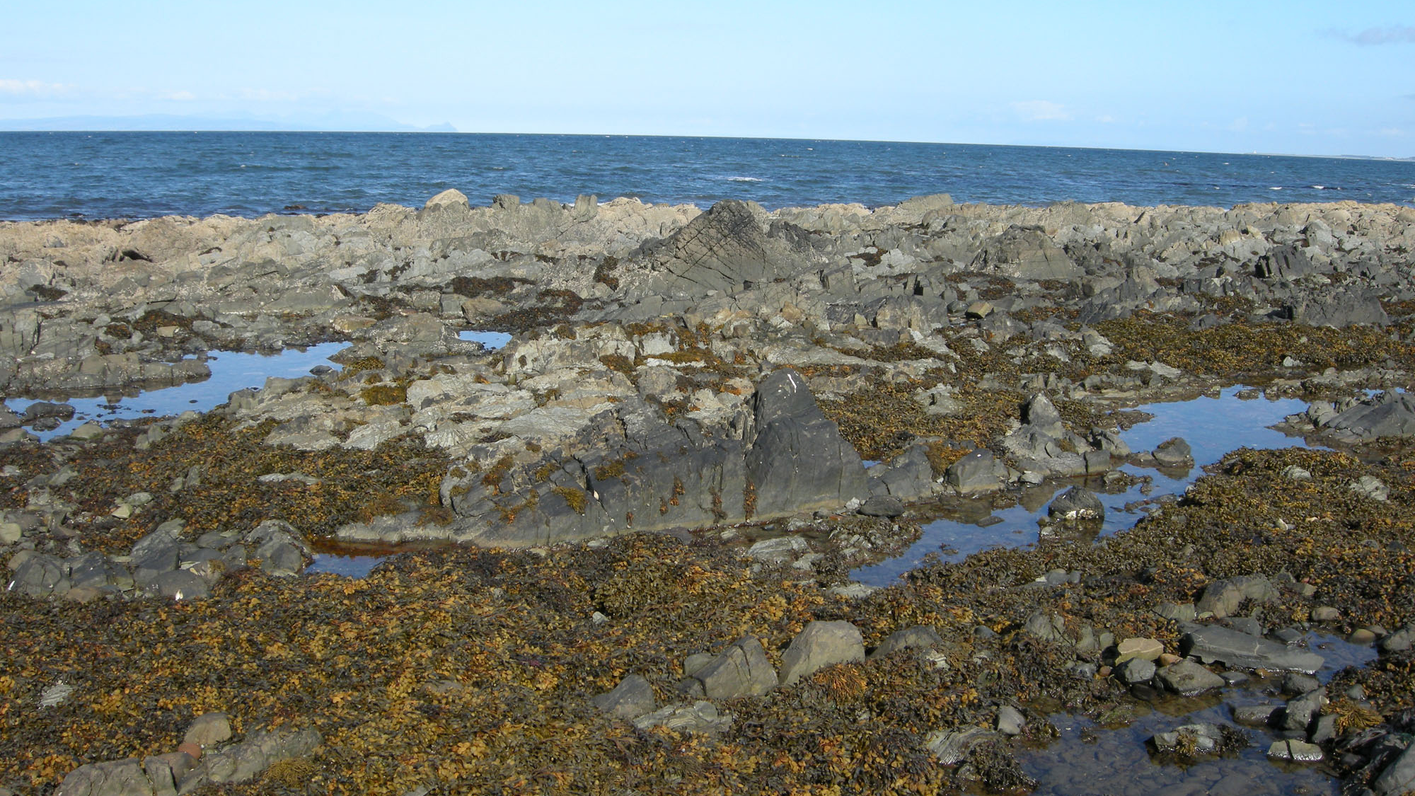
Overview
Directions
- This guide covers the coast from Shalloch to Whitehouse, including Myoch Bay, Woodland Bay and Woodland Point. From Girvan, approach the northern end via the A77 Shalloch Park roundabout and the established Shallochpark/Ainslie parking area.
- The coastal-path route identifies Ainslie car park at KA26 0HW, with toilets and a snack bar at the northern end. Check parking signs, charges and facility opening times on arrival; the rocky foreshore itself is not an accessible surfaced route.
- The original guide describes just over 3 km from the Shalloch car park to Whitehouse. Allow time for the uneven shore and tides, or split the coast into northern and southern visits rather than trying to examine every exposure in one outing.
- For the Whitehouse end, use only designated, lawful parking spaces and a safe pedestrian approach. Do not stop on the A77 carriageway or block entrances. Historical layby descriptions are not a promise of available parking.
- Original guide location reference: 55.22037°N, 4.86936°W. This identifies the wider locality, not a verified parking place or safe shore descent.
Location photographs
Swipe to browse · Select a photograph to enlarge


Fossil Hunting
The fossils here are best understood by keeping the rock type and part of the coast with each observation. The red and green Myoch mudstones, grey-green Mill shales, relatively barren Shalloch sandstones and shell-rich Silurian beds at Woodland Point represent different environments and ages. A loose specimen cannot be assigned reliably merely because it was found in the middle of Woodland Bay: faults repeat beds and the sea moves material between exposures.
At Myoch Bay and Whitehouse, the red silty mudstones of the Myoch Formation contain an important deep-water trilobite association. Blind or small-eyed bottom-dwellers such as Dionide occur with large-eyed swimming forms, including Cyclopyge and Degamella. Other recorded genera include Novaspis, Nankinolithus, Microparia, Psilacella, Ellipsotaphrus, Telephina, Bohemilla and Raphiophorus; these records do not make every genus a likely find. Small brachiopods of the Foliomena community accompany them. Look closely at naturally weathered mudstone surfaces for curved segments, ribbed fragments and small shell impressions rather than expecting complete trilobites.
The Mill Formation has a different fossil story. At Myoch Bay, thin basal black shale carries Dicellograptus complanatus, D. gravis and members of the Orthograptus calcaratus group. Graptolites may appear as delicate, flattened branching traces; a hand lens and oblique light help distinguish their repeated tiny cups from cracks or mineral markings. The black shale is interrupted tectonically, so a fossil-rich horizon in the literature is not a continuous seam that can simply be followed along the beach.
Above the lower Mill shale and siltstone at Myoch Bay, a calcareous mudclast conglomerate contains transported brachiopods, trilobites and gastropods. Recorded examples include Tretaspis cf. hadelandica convergens, Skenidioides greenoughi, Onniella, Orthambonites and, at a particular mapped exposure, Cryptolithus lotus lotus. Shell debris in this rock was carried down from a shallower shelf; it is not the same living community as the trilobites in the Myoch red mudstones. Do not target the rare igneous pebbles or distinctive clasts: they are part of the scientific value of the exposure.
At the three small stacks on Whitehouse shore, the reduced Mill succession has grey-green laminated silty shales with graptolites and thin seams of transported trilobite remains. Dindymene and Aethidionide are recorded here, alongside cyclopygid material. The upper sandy beds contain broken shell debris and occasional fossils. This is the setting of important historic Gray collection material; it should not be described simply as fossiliferous “Whitehouse Formation” shale, because Whitehouse is now a subgroup containing several distinct formations.
The Shalloch Formation makes much of the strongly bedded shore between the northern part of the route and Whitehouse. Fossils are generally sparse. Published records include graptolites in a thin detrital carbonate about 9 m above its base at Whitehouse, higher anceps-zone graptolites, and microscopic conodonts in a separate limestone horizon. These are scientific records of particular beds, not a prediction that every shale parting contains graptolites. The distinctive lead-grey basal mudstone is described as unfossiliferous.
At Woodland Point, the Silurian Woodland Formation begins with shell-rich sandstone and calcareous lenses. More than 30 brachiopod species have been recorded in the lower part, historically dominated by Stricklandia lens lens. Ribbed or folded shell sections may stand out on naturally weathered surfaces. In the middle part, Stricklandia and Clorinda communities include shells preserved in life position, whereas many lower shells were transported. The thin upper siltstone and shale contains the well-documented graptolite band 4 m below the formation top. This restricted horizon, rather than all shales in the bay, establishes the late Rhuddanian age.
Woodland Point is also the type locality of the trilobites Stenopareia acymata and Acernaspis xynon, as well as several brachiopods. These type records explain its importance but do not imply that rare named species can be recognised or found routinely on a short visit. The coarse Scart Grits above are primarily a sedimentological interest; the main modern stratigraphic account reports no fossils from them.
Begin with photographs of exposed bedding surfaces and naturally detached material, keeping a scale and a wider location view. Record the bay, rock colour and texture, and whether the piece was loose; avoid assigning a precise bed to a wave-moved block. Before taking material, establish the landowner’s permission and any necessary protected-site consent. Do not split or pry attached beds, or enlarge fossil-bearing seams. Leave uncertain or scientifically unusual finds in place and seek advice with photographs.
Fossil photographs
Swipe to browse · Select a photograph to enlarge


Discoveries and milestones
Significant discoveries and geological milestones along the Shalloch–Whitehouse coast.
1882 – A detailed coastal succession
Charles Lapworth published a bed-by-bed account of the Whitehouse, Myoch and Woodland succession, acknowledging fossil material collected by Mrs Gray and himself. His Myoch Bay log preserved the fossiliferous shale, calcareous beds and colour changes that remain important when comparing historical and modern terminology.
1899 – Geological Survey synthesis
Peach and Horne described the coastal succession and extensive fossil lists from Elizabeth Gray’s Whitehouse and Shalloch Mill collections. Their synthesis recorded a major body of early collecting evidence, although some of its age terms and structural interpretations have since changed.
1917 – Woodland brachiopods described
F. R. Cowper Reed described brachiopods based on Woodland Point material, including taxa subsequently listed as Triplesia woodlandensis, Katastrophomena woodlandensis, Leptostrophomena jamesoni and Fardenia (Saughina) pertinax. The species later reassigned to Leontiella tenax was also named in this work.
1966 – Life-position communities recognised
Ziegler and colleagues documented brachiopod communities preserved in life position in the middle Woodland succession. This evidence helped distinguish a living shelf community from shell material transported into other beds.
1968 – Further brachiopod type material
L. R. M. Cocks named Leptaena? reedi and Leptaena valentia, both recorded with Woodland Point as their type locality. The question mark in the first combination reflects the published generic uncertainty.
1970 – Higher Shalloch graptolites
P. Toghill recognised graptolites of the anceps Biozone higher in the Shalloch succession, adding an important constraint on the correlation of these otherwise fossil-poor beds.
1972 – Statutory site protection
The Girvan to Ballantrae Coast Section was first notified as a Site of Special Scientific Interest. Its geological interest includes Woodland Point and the fossiliferous coastal succession covered by this guide.
1973 – Woodland stratigraphy revised
Cocks and Toghill established the unconformable relationship between the Ordovician rocks and the younger Woodland succession. Their work measured 21.7 m of Woodland Formation and 45 m of exposed Scart Grits, whose top is not seen.
1978 – A Woodland lectotype selected
Cocks selected specimen B 74637 as the lectotype of the Woodland Point brachiopod then known as tenax. This designated reference specimen later underpinned its reassignment to a different genus.
1982 – Two trilobite species named
Y. Howells named Stenopareia acymata and Acernaspis xynon, both with Woodland Point as type locality, establishing the shore’s importance in Scottish Silurian trilobite taxonomy.
1984 – The Whitehouse formations formalised
Harper’s brachiopod monograph, incorporating Ingham’s stratigraphic work, formally subdivided the Whitehouse succession. The Whitehouse foreshore became the type section of the Myoch Formation, separating units that older accounts treated within broader Whitehouse divisions.
1985 – Conodont evidence illustrated
Aldridge illustrated conodonts from a calcareous bed 2 m above the Woodland base, including an early Distomodus form then identified as D. kentuckyensis. This added microscopic fossil evidence to the shelly and graptolitic record.
1987 – Graptolite correlation refined
S. Henry Williams revised graptolites from the Dicellograptus complanatus Biozone, including the rich lower Mill assemblages and lower Shalloch records. The work strengthened comparisons between Girvan and other Upper Ordovician successions.
1989 – SSSI re-notification
On 31 March the Girvan to Ballantrae Coast Section was re-notified under the Wildlife and Countryside Act 1981, continuing protection of its nationally important geological features.
1990 – Conodont horizons correlated
Bergström’s conodont study documented an Amorphognathus ordovicicus-zone assemblage in a limestone 117 m above the Shalloch base, together with A. superbus-zone evidence from Southshore beds. These horizons complement the graptolite correlations.
1992 – Detailed foreshore mapping
Ingham published detailed maps and descriptions distinguishing the fuller Myoch Bay succession from the reduced Mill section at Whitehouse. The account showed why erosion, channel fills and faulting prevent a simple bed-for-bed reading of the whole coast.
2000 – Conservation accounts and revised hierarchy
The Geological Conservation Review set out Woodland Point’s type-locality and palaeoecological importance and the Girvan foreshore’s value for Ordovician correlation. In a separate revision of Ordovician correlation, Fortey and colleagues placed the Shalloch Formation within the Whitehouse Subgroup.
2003 – The Silurian framework revised
Floyd and Williams established the Girvan Group and Newlands Subgroup and formally named the Cow Rock Conglomerate Member at the base of the Scart Grits. Their paper was published in 2003 in a volume bearing the year 2002.
2009 – Historic material reclassified
Cocks reassigned the Woodland Point brachiopod tenax to Leontiella, illustrating the lectotype and other specimens from the type locality. The revision linked Reed’s original species to a modern generic interpretation.
Geology
This coast exposes a changing marine basin on the ancient Laurentian margin, followed by early Silurian sedimentation across an eroded Ordovician surface. It is not a continuous sequence of three formations. The Late Ordovician rocks belong to the Ardmillan Group and its Whitehouse Subgroup, which includes Southshore, Threemile, Penwhapple, Myoch, Mill and Shalloch formations. The historical terms Caradoc, Ashgill, Lower Whitehouse and Upper Whitehouse in older accounts need to be read alongside the modern hierarchy; the whole succession is not Caradoc in age.
The southern Whitehouse exposures record sediment moving from a shallower shelf into deeper water. Southshore sandy limestones contain transported shell debris, while the thinner sandstones and shales of Threemile represent more distant sediment flows. The finer red and green Myoch mudstones accumulated around a submarine fan. Their red colour reflects iron oxides and does not imply a desert or river deposit: the associated deep-water fauna and oxygenated sea-floor interpretation are essential parts of the story.
The Mill Formation demonstrates how much one exposure can differ from another only a short distance away. At Myoch Bay, graptolitic shale and calcareous siltstone lead into a mudclast-rich mass-flow deposit and an upper shale interval. At Whitehouse, the lower part is missing and the remaining shales, sandy beds and a terminal channel sandstone rest sharply on Myoch mudstone. Broken and mixed sediment, slumps and abrupt lateral changes record an unstable sea floor before later tectonic deformation folded and faulted the rocks.
The Shalloch sandstones and silty shales were deposited by repeated sediment-laden underwater flows. More than 200 m is represented on the Girvan foreshore, but beach width cannot be used as a simple thickness measure: near-vertical bedding, faults and sand-covered gaps interrupt the outcrop. The small number of fossil-bearing carbonate and shale horizons is particularly valuable for dating these largely barren beds.
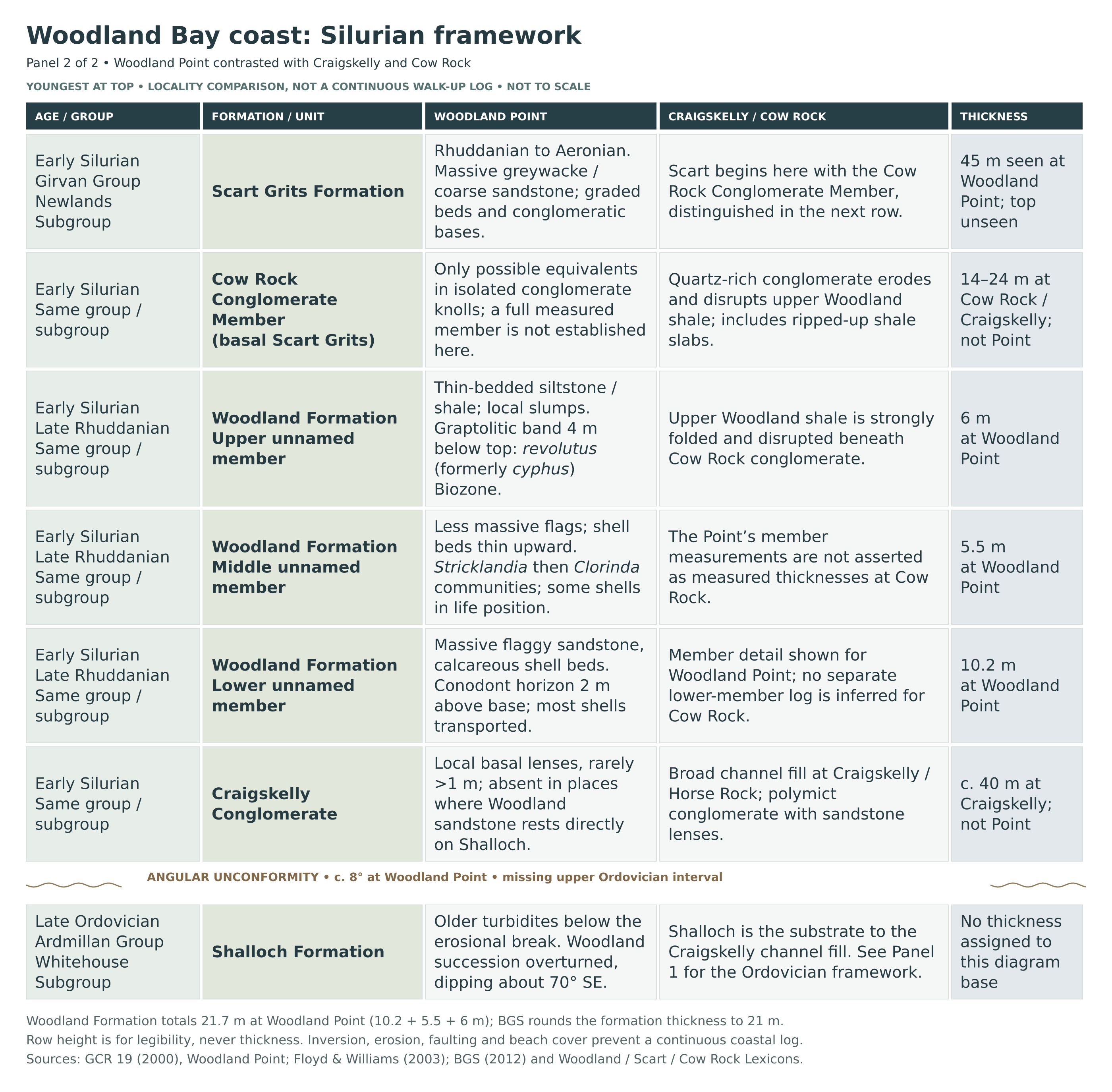
At Woodland Point, early Silurian sediment overlies the truncated Ordovician rocks across an angular discordance of about 8°. Locally there are thin basal conglomerate lenses; elsewhere Woodland sandstone rests directly on Shalloch. The much thicker Craigskelly Conglomerate at Craigskelly and Horse Rock is a different expression of this uneven, channelled surface, not a 40 m bed beneath Woodland Point. Parts of the younger Ordovician succession are missing at this coast.
The measured Woodland Formation is 21.7 m thick and late Rhuddanian in age. Its lower shell-rich sandstones pass into less massive flaggy beds and then thin siltstones and shales, recording a changing shelf environment and fossil communities. The graptolite horizon in the upper part has been called the cyphus Biozone in older work and the revolutus Biozone in the BGS regional account. Above it, coarse Scart Grits record renewed sediment flows; the BGS formation range is Rhuddanian–Aeronian. At Cow Rock, a quartz-rich basal conglomerate eroded and disturbed Woodland mud, and that local thickness must not be transferred wholesale to the Point.
The beds were subsequently steepened, overturned and faulted. Woodland’s inverted succession dips about 70° south-east, while faults repeatedly offset the Ordovician shore. Much younger Paleogene dolerite dykes cut the sedimentary rocks and locally baked them. Distinguishing these intrusions and brittle faults from earlier sedimentary slumps is part of reading the shore correctly; the charts and detailed account below show the separate sections and missing intervals rather than a falsely continuous walk-up log.

Detailed geology and bed-by-bed succession
Detailed geology and stratigraphy
This account covers the coastal sections from Shalloch and Craigskelly through Myoch Bay, Black Neuk and Woodland Point to Port Cardloch and the Whitehouse shore. The succession is described from older to younger rocks, but it is not a single uninterrupted beach section. Faults remove and repeat beds, submarine channels change the thickness of individual units, and an erosional break separates the Ordovician and Silurian successions. The lower Whitehouse units are included where they enter this coastal stretch; the older Ardwell succession farther south is outside the detailed account.
How the separate exposures fit together
Local sections and thicknesses. Whitehouse provides the southern lower-unit exposures and the type section of the Myoch Formation, but its Mill Formation is reduced compared with Myoch Bay. Black Neuk shows another Mill–Shalloch relationship, without Whitehouse’s terminal Mill sandstone. Woodland Point provides the measured Woodland Formation and the exposed Scart Grits succession. Craigskelly and Cow Rock preserve thicker conglomerates than those seen at Woodland Point. All numerical thicknesses below are tied to their stated section; regional formation totals cannot be added together to obtain the thickness exposed in Woodland Bay.
Modern and historical names. The Ordovician rocks described here belong to the Ardmillan Group and Whitehouse Subgroup. “Lower Whitehouse” and “Upper Whitehouse” in older guides are historical divisions, rather than additional groups in the modern hierarchy. Shalloch Formation is now included in Whitehouse Subgroup, following the revised correlation of 2000. The succession is Late Ordovician, broadly Katian; older Caradoc and Ashgill terminology remains useful when reading the classic papers, but neither the whole coast nor all of its fossil beds should be labelled Caradoc.
ARDMILLAN GROUP
The Ardmillan Group includes the Late Ordovician marine sedimentary succession on this part of the Girvan coast. Its Whitehouse Subgroup records changes between carbonate-rich sediment flows, finer deep-water deposits and sandstone-rich submarine-fan sedimentation. The rocks discussed below are the coastal representatives of this wider succession.
WHITEHOUSE SUBGROUP
The modern subgroup contains the Southshore, Threemile, Penwhapple, Myoch, Mill and Shalloch formations. Its regional thickness is about 600 m, but this is not a measured continuous Woodland Bay section. Variation between Whitehouse, Myoch Bay and Black Neuk is essential to understanding the succession, especially where faults or sedimentary erosion have removed beds.
Southshore Formation
Sandy limestones and shale, about 75 m in the Girvan foreshore section. Around the northern Ardwell–Whitehouse transition, detrital sandy limestones alternate with grey and green shale. The change from the underlying Ardwell rocks is sharp; this lower boundary lies at the southern geographical edge of the present account. Grading and Bouma divisions, the successive sedimentary structures within individual turbidites, indicate relatively proximal turbidity currents; some flows deposited composite, multiple units. Basal fragments include pieces eroded from older rocks, with fragments of Ardwell Flags recorded in the oldest bed.
The limestones contain broken shelf-derived fossils, including trilobites, brachiopods and corals, carried downslope with the sediment. The Tretaspis ceriodes species group is recorded, and conodont evidence includes the Amorphognathus superbus Zone. These transported remains record the source of the sediment as well as its final deep-water resting place.
Threemile Formation
Thin sandstone beds in grey-green shale, more than 45 m on the foreshore. The Threemile Formation, written “Three Mile” in older accounts, is less calcareous than Southshore. Its thin, very persistent sandstone beds and intervening shale are interpreted as more distal turbidites. Two or three thicker sandstone beds provide useful markers in the older foreshore description; these are unnamed beds, with no separately verified thicknesses, rather than formal members.
Penwhapple Formation
A missing shore interval and a nearby burn exposure. At Whitehouse, a reverse fault running approximately parallel to the strike cuts out the Penwhapple Formation, so it cannot be shown as a complete exposed interval between Threemile and Myoch on that shore. Dark shale with occasional sandstone is recorded in Myoch Burn a short distance upstream of the road, where graptolites indicate the linearis Biozone. The approximately 90 m section measured inland in Penwhapple Burn is a regional comparison, not a thickness for this coast. Historical references to the Byne-Hill Burn succession should be read with their original locality descriptions rather than assumed to identify every modern burn exposure.
Myoch Formation
Red and green silty mudstones dominate the Myoch Formation, with coarser sandstone and conglomerate near its base and locally within it. The BGS Lexicon gives a regional thickness of about 30 m and identifies Whitehouse foreshore as its type section. Faulting and lateral facies changes prevent that figure from being used as a measured thickness for each exposure. In the older British scheme the formation spans the Caradoc–Ashgill transition; modern discussion should retain the broader Late Ordovician context rather than treat the historical boundary as a universally exact fossil-zone boundary.
Basal conglomerate near Myoch Bridge. The fuller local succession begins with a coarse conglomerate containing a sandstone and mudstone matrix. It is distinct from the finer red and green mudstones higher in the formation. No secure local thickness is given for this basal unit.
Near-basal sandstone at Whitehouse. Pebbly, cross-bedded sandstone is exposed in a restricted low-water area southwest of the central shore. Its sedimentary structures indicate currents arriving from the north-west. The reverse fault removes other parts of the lower succession, leaving a limited view of this early coarse sedimentation.
Port Cardloch sandstone. Thick cross-bedded sandstone beds with shale clasts occur beside the road in a faulted patch at Port Cardloch. They show the near-basal coarse facies more clearly than the restricted Whitehouse exposure and are interpreted as channel-fill sands associated with early submarine-fan development. They are part of the Myoch succession, not a separate formation, and no numerical thickness is assigned to this patch.
Lower green silty mudstones. Above the coarse basal deposits, the lower fine-grained succession comprises green silty mudstone. This is the lowest of the three colour divisions described in the modern field account and should be distinguished from the overlying colour-banded transition and red upper mudstones.
Red and green transitional mudstones. Alternating red and green bands mark the passage from the lower green mudstones into the predominantly red upper interval. The banding is a useful field distinction, but the published coastal accounts do not establish a separate formal member or a reliable modern measured thickness for it.
Upper red silty mudstones and their deep-water fauna. Predominantly red silty mudstone contains an important in-situ deep-water association in its upper part. The cyclopygid–atheloptic association includes blind or small-eyed bottom-dwelling trilobites alongside large-eyed swimming forms, together with small brachiopods of the Foliomena community. Recorded trilobites include Dionide, Novaspis, Nankinolithus, Cyclopyge, Degamella, Microparia, Psilacella, Ellipsotaphrus, Telephina, Bohemilla and Raphiophorus; these names do not imply that every genus had the same mode of life.
The red mudstones are interpreted as fine overbank sediment deposited on a deep-water submarine fan. Their iron-oxide colour, considered alongside the benthic fauna, indicates an oxygenated sea-floor substrate rather than a terrestrial red-bed environment. The ecological interpretation is more secure than any attempt to turn it into an exact water-depth measurement.
Local sandstone–shale channel fill in the red mudstones. Near the road at Myoch Bay, a channel-fill package lies within the red beds. It occupies a plunging syncline in which red mudstones reappear in the core; a thrust truncates the exposure seawards, and an adjacent Myoch section lacks the channel fill. Its local thickness has not been established. Although the Balgaverie Member is a named upper-Myoch channel-fill unit in the inland Penwhapple Burn type context, the published evidence used here does not justify assigning that name or its approximately 8 m thickness to this coastal package.
Sandstone-filled fissures. Sandstone dykes cut the Myoch mudstones on the Whitehouse shore. These are sediment-filled fissures associated with disturbance of the sedimentary succession. They are neither additional layers in the normal depositional sequence nor the much younger igneous dolerite dykes also found along the coast.
Mill Formation
The Mill Formation records renewed introduction of coarser and calcareous sediment, together with graptolitic shale. It is not represented by the same succession at every exposure: Myoch Bay preserves a fuller lower part, whereas erosion removed lower Mill beds before the reduced Whitehouse section accumulated. Its historical Ashgill assignment and complanatus-zone fossils are useful for correlation, but the lithological base and historical stage boundary should not be treated as automatically identical.
Myoch Bay: basal to near-basal graptolitic shale. Thin black shale occurs in tectonically interrupted exposures identified as localities 11A, 11B and 11G in Ingham’s foreshore account. It contains abundant Dicellograptus complanatus and D. gravis, with members of the Orthograptus calcaratus group. Williams’s revision places the assemblage low in the complanatus Biozone, close to the transition from the preceding linearis interval. The fossil assemblage is more informative than the apparent width of these faulted shale exposures.
Myoch Bay: calcareous siltstones above the basal shale. The succession coarsens upwards through calcareous siltstone towards the overlying conglomeratic channel fill. Lapworth’s historical Dictyonema interval probably belongs within this lower Mill package, but its precise equivalence to a particular modern bed or member is not independently established. His original description is retained separately below.
Myoch Bay: mudclast conglomerate and calcareous channel fill. This mass-flow deposit is less than 1 m thick where first encountered near the sea wall but thickens markedly seawards. A grey calcareous mudstone matrix surrounds deformed grey and green mudstone and siltstone clasts, with limestone fragments and rare igneous pebbles derived from a shallower platform. The unit is absent at Black Neuk, demonstrating that it is a restricted sedimentary body rather than a constant layer across the coast.
Its matrix carries transported shelf fossils, including brachiopods, trilobites and gastropods. Tretaspis cf. hadelandica convergens and Skenidioides greenoughi support the traditional early Ashgill correlation; Onniella and Orthambonites are also recorded. Cryptolithus lotus lotus is particularly associated with locality 11H. Its Laurentian affinity links the transported shelf fauna to the ancient North American side of the Iapetus Ocean. This fauna differs in origin from the largely in-situ deep-water association of the underlying Myoch red mudstones. The rare igneous-pebble occurrence at locality 11C is a scientifically important protected feature, not a collecting target.
Myoch Bay and Black Neuk: upper shale interval. About 16 m of grey-green silty shale overlies the conglomerate at Myoch Bay, with occasional graptolites of the complanatus Biozone. Much of this interval corresponds broadly to the thinner, shalier and sandier Mill succession at Whitehouse, but individual beds cannot be matched one for one. At Black Neuk, a thicker shale-dominated upper Mill succession lies beneath Shalloch without the terminal sandstone seen at Whitehouse.
Whitehouse: sharp base and disturbed mixed sediment. Here the Mill Formation rests abruptly on red Myoch mudstones, with the lower Mill succession seen at Myoch Bay missing. In the rock-pool exposure between the first and second small stacks, partly consolidated sediments are disturbed and mixed. This is interpreted as mass movement on an unstable submarine slope, explaining why a complete Myoch Bay log cannot simply be transferred to Whitehouse.
Whitehouse: lower shale member, an informal subdivision. Laminated grey and green silty shales occur on and around the three small stacks. Graptolites indicate the complanatus Biozone, while thin seams contain transported cyclopygid and other atheloptic trilobite remains. Dindymene and Aethidionide are specifically recorded in the older field guide. These beds supplied material associated with the historic Gray collection in the Natural History Museum; the published description does not give a separate numerical thickness for each fossil seam.
Whitehouse: upper sandy and silty member, an informal subdivision. Cross-bedded sandstone and siltier beds contain comminuted shell debris derived from the west and occasional more recognisable fossils. Slumping is especially clear on the seaward side of the middle stack. “Lower shale” and “upper sandy and silty” are useful descriptive divisions here, not formally named members deserving separate lithostratigraphic rank.
Whitehouse: terminal channel-fill sandstone. A distinctive thick sandstone bed occurs beyond the stacks towards low water, immediately below the basal lead-grey mudstone of the Shalloch Formation. No measured thickness is established in the cited account. Its absence at Black Neuk is an important lateral difference and it should not be assumed to mark the Mill top everywhere.
Shalloch Formation
The Shalloch Formation is the youngest Ordovician unit exposed in this coastal account. Although older literature separated it as the “Barren Flagstones”, it is now placed within the Whitehouse Subgroup. More than 200 m is represented in the Girvan foreshore succession; the BGS estimate of approximately 300 m is a regional formation thickness, not a fully measured Woodland exposure. Its regional relationship to younger Ordovician rocks elsewhere cannot be substituted for the local erosional contact beneath the Silurian.
Basal leaden-grey mudstone, about 1 m. The basal marker is described as unfossiliferous. It is well displayed in a curved gully at Myoch Bay and, at Whitehouse, above the terminal Mill sandstone. At Black Neuk it instead overlies upper Mill shale. This thin marker must be distinguished from Lapworth’s much broader lower “Barren Flagstones” interval, which included fossil records from above the basal metre.
Main sandstone–shale alternation. Fine- to medium-grained turbidite sandstone alternates with siltstone and shale through the main Shalloch succession. Compared with the Myoch and Mill fossil horizons, these beds are generally fossil-poor. Near-vertical dips, fault repetition and sand-covered gaps make beach width an unreliable measure of thickness, even where the regular alternations appear to form a straightforward sequence.
Detrital carbonate horizon about 9 m above the base. On the Whitehouse shore, a thin carbonate-rich bed contains graptolites of the complanatus Biozone. It is an individual fossil-bearing horizon within the otherwise relatively unfossiliferous lower Shalloch succession, rather than evidence that every adjoining shale bed will contain the same fauna.
Conodont-bearing limestone 117 m above the base. A limestone horizon in the Girvan foreshore Shalloch succession yields a rich conodont assemblage of the Amorphognathus ordovicicus Zone. The measured position is reported by the GCR account, drawing on Bergström’s study. It identifies a stratigraphic horizon rather than a guaranteed present-day exposure beside a particular access point.
Higher graptolite and shelly horizons. Higher beds yield graptolites assigned to the anceps Biozone, and rare detrital carbonate beds contain lower to middle Ashgill shelly debris in the older regional terminology. The sources do not provide a single fixed thickness or a formal bed name for all these higher occurrences, so they should not be compressed into one precisely positioned marker.
Lapworth’s historical Myoch Bay and Barren Flagstones log
Lapworth’s 1882 account preserves bed-level observations that remain useful beside the modern formation names. The intervals below retain his descriptive divisions and approximate imperial measurements, with metric equivalents supplied for clarity. They are not newly named members, should not be added to modern formation totals, and cannot be imposed on the truncated Whitehouse section. Historical fossil names are retained as historical identifications.
Low coarse sandstone. Lapworth described a coarse, thick, gritty sandstone low in the succession and compared it with the faulted sandstone patch at Port Cardloch. No numerical thickness was given. It records the same broad coarse-to-fine transition recognised in the modern Myoch account without establishing an exact bed-to-bed correlation.
Green shale and harder gritty flags: at least 40 ft, about 12.2 m. This lower fine-grained interval was exposed south of Myoch Bay. The measurement belongs to Lapworth’s historical section and classification, not to an independently remeasured total for a modern formation.
Lower transitional band: about 15 ft, 4.6 m. Soft green mudstone and shale contain purple lines, marking the first historical colour transition above the lower green beds.
Purple mudstone band: estimated at no more than 30 ft, 9.1 m. Strong folding made the thickness uncertain. Its position between the lower and upper transitional bands is part of the historical log; the estimate should not be treated as an undeformed modern measured section.
Upper transitional band: estimated 20 ft, 6.1 m. Green mudstone with purple seams succeeds the more uniformly purple interval. This historical colour subdivision is more detailed than the broad modern description of red and green Myoch mudstones, but the two schemes do not have independently demonstrated identical boundaries.
“Complanatus zone” bed package: 5 ft, about 1.5 m. Carbonaceous black shale alternates with grey mudstone and seams of calcareous grit. Graptolites were abundant, including material reported under the historical name Diplograptus socialis. Lapworth’s thickness applies to this lithological package, not to the full thickness of the modern complanatus Biozone.
“Dictyonema zone”: 9 ft, about 2.7 m. Hard, flaggy shales with grey calcareous ribs contained fossils described as Dictyonema and Ganocladium, together with lingulids and other remains. These historical names and the bed description are useful evidence, but no unsupported modern taxonomic replacement or exact member correlation is implied.
“Dionide beds”: about 6 ft, 1.8 m. The original 1882 description specifies very calcareous mudstones, locally passing into impure nodular limestone. Peach and Horne’s later quotation used “sandstones”; the original lithological wording is followed here. This higher historical fossil interval is distinct from the in-situ Dionide-bearing fauna of the Myoch red mudstones. The whole 6 ft cannot securely be equated with a modern conglomerate member.
Lower “Barren Flagstones”: first 50 ft, about 15 m. Lapworth described pale-green mudstone and very thin flags, recording the historical fossil name Nematolites Grayii. This is a broad lower part of the old division, not the same unit as the approximately 1 m unfossiliferous basal Shalloch marker.
Middle “Barren Flagstones”: changing sandstone-bed thickness. Flags initially about 1 ft, 0.3 m, thick occurred at intervals of around 3 ft, 0.9 m. Higher in this part of the log, individual flagstone beds increased to 3–4 ft, about 0.9–1.2 m, with shale partings only inches thick. Upwards again, the flags became thinner and shale more prominent. These changes retain useful sedimentological information without requiring an unsupported modern member name.
Historical Woodland thickness estimate: 500 ft, about 152 m. Lapworth estimated the “Barren Flagstones” thickness from the width of the Woodland outcrop and its near-vertical bedding. It is an important early estimate, but the modern foreshore figure of more than 200 m and regional Shalloch estimate of about 300 m are preferred in their respective geographical contexts.
The Ordovician–Silurian break
Truncated Shalloch and an angular unconformity. The local Ordovician succession ends below an erosional surface, with the upper Cautleyan through Hirnantian interval missing. Younger Ordovician rocks, including the Drummuck succession and Auldthorns Formation, are not exposed in the coastal succession described here. At Woodland Point the discordance between the Ordovician and Silurian beds is about 8°. The relationship is interpreted in terms of submarine erosion and channel development, rather than a simple unbroken passage between the two systems.
The basal Silurian conglomerate changes sharply in thickness along the coast. At Craigskelly it forms a substantial channel fill, whereas at Woodland Point only intermittent thin lenses may intervene between Shalloch and Woodland sandstones. Where a lens is absent, Woodland sandstone rests directly on Shalloch. An older statement that basal conglomerate is entirely absent from Woodland Point is therefore too categorical.
GIRVAN GROUP
The Silurian rocks of this coast belong to the Girvan Group. The group name was established within the revised Girvan stratigraphic framework published by Floyd and Williams in 2003, for the journal volume dated 2002. Here its lowest subgroup records the return of sedimentation above the Ordovician erosion surface and the transition from shell-rich shelf deposits to coarser sediment flows.
NEWLANDS SUBGROUP
The coastal Newlands succession comprises Craigskelly Conglomerate, Woodland Formation and Scart Grits Formation, with the Cow Rock Conglomerate Member at the base of Scart. The subgroup has a regional Rhuddanian–Aeronian age range. Its much larger regional thickness includes rocks outside this coast and is not a thickness for Woodland Bay; inland Saugh Hill Grits should not be added as another formation above the exposed Scart succession.
Craigskelly Conglomerate
Craigskelly and Horse Rock: about 40 m of polymict conglomerate. The coarse basal Silurian unit lies unconformably on Shalloch and is interpreted as a broad channel fill. Rounded clasts include acidic and basic igneous rocks, greywacke, jasper and metamorphic material, with sandstone lenses within the conglomerate. This varied clast assemblage helps distinguish it from the younger, quartz-rich Cow Rock Conglomerate Member.
Woodland Point: intermittent basal lenses, rarely more than 1 m. The equivalent basal coarse deposits are much thinner here than at Craigskelly and may be absent between Woodland sandstone and Shalloch. Their limited development is evidence of lateral change in the erosional surface and channel fill; the 40 m Craigskelly thickness must not be transferred to Woodland Point. Older descriptions also note a final vestige towards Scart Rocks, without implying a continuous conglomerate sheet between every exposure.
Woodland Formation
The Woodland Formation at Woodland Point is late Rhuddanian, within the early Silurian Llandovery. The measured succession is 21.7 m thick, divided descriptively into a 10.2 m lower interval, 5.5 m middle interval and 6 m upper interval. The BGS Lexicon rounds its thickness to 21 m. “Woodland Formation” is the current formal name used here; historical names include Woodland Limestone and Striped Shale. The three lower, middle and upper divisions are unnamed, so they are described below without inventing formal geographical member names.
Lower member: 10.2 m of massive flaggy sandstone and calcareous shell beds. The lower interval contains strongly calcareous, shell-rich beds and lenses within massive flaggy sandstone. More than 30 brachiopod species have been recorded from the lower formation, with Stricklandia lens lens prominent in the historical account. Most shells in this lower part were transported before burial, contrasting with some of the life-position brachiopods higher in the formation.
Conodont-bearing calcareous bed, 2 m above the formation base. This distinct microfossil horizon contains an early form of Distomodus, figured by Aldridge in 1985 as D. kentuckyensis. The qualified identification is retained because the historical species assignment should not be made more definite than the locality account allows.
Middle member: 5.5 m of less massive flags and diminishing shell beds. Thin shell beds become less frequent upwards. A Stricklandia community occurs in the lower part of the middle interval, followed by a predominantly Clorinda community. Some brachiopods remain in life position, providing direct evidence for the shelf communities that inhabited the sea floor rather than only for shells carried in from elsewhere.
Upper member: 6 m of thin-bedded siltstone and shale. The upper interval is locally slumped and is only intermittently visible through beach cover. At Cow Rock, the corresponding upper Woodland shales are strongly folded and disrupted beneath the overlying conglomerate. That deformation does not provide a separate reliable thickness measurement for the Cow Rock exposure.
Graptolitic band, 4 m below the Woodland top. A diverse graptolite fauna gives the principal late Rhuddanian age control for the succession. The GCR describes it in the upper cyphus Biozone; the later BGS regional account uses revolutus, formerly cyphus. This change in zonal terminology does not shift the Woodland Formation out of the Rhuddanian. The fossil occurrence belongs to this particular upper-member band, not to every shale exposed in the bay.
Fossils and type material. Woodland Point is the type locality for the trilobites Stenopareia acymata and Acernaspis xynon, described by Howells in 1982, and for several brachiopods listed in the GCR account. Its type-locality list includes Lingula tenax, Triplesia woodlandensis, Katastrophomena woodlandensis, Leptaena? reedi, Leptaena valentia, Leptostrophomena jamesoni and Fardenia (Saughina) pertinax. These are the combinations used in that account, rather than a claim that every name remains taxonomically current. Cocks’s 2009 revision placed tenax in Leontiella and identified the Woodland Point lectotype B 74637, selected in 1978, together with topotypes B 74578–79, BC 1800–08 and BC 2255. The BGS regional account also illustrates Eostropheodonta mullochensis, specimen GSE 875, from Woodland Point. These records add to the importance of the measured succession, but they do not establish that every named species occurs in a single shell bed.
Scart Grits Formation
Coarse sandstone succession: 45 m exposed at Woodland Point, with the top unseen. Massive greywacke and coarse sandstone show normal and inverse grading, with conglomeratic bases to some beds. The BGS interpretation is of turbidite deposition. The formal age range is Rhuddanian–Aeronian, so the entire exposed formation should not be narrowed to the late Rhuddanian age established for the underlying Woodland beds. Floyd and Williams reported no fossils from Scart Grits; it is the sedimentary structures and basal conglomerate relationships that are especially informative here.
Cow Rock Conglomerate Member
Basal Scart conglomerate: 14–24 m at Craigskelly and Cow Rock. The formally named member contains abundant quartz clasts, with igneous material and shale flakes in a sandy matrix. It erodes and disturbs the underlying upper Woodland shales, locally incorporating ripped-up shale slabs and injecting the soft sediment. A fan-like pattern of folds beneath the conglomerate records this disturbance. Its quartz-rich character contrasts with the more varied basal Craigskelly Conglomerate below the Woodland Formation.
The name Cow Rock Conglomerate Member was formalised by Floyd and Williams; older sources use Quartz Conglomerate Member or Haven Conglomerate Member. At Woodland Point, isolated conglomerate knolls may represent an equivalent of this basal Scart unit, but they do not demonstrate that the full 14–24 m Cow Rock thickness is present there or that the member can be traced continuously between the two sections.
Folds, faults and later intrusions
Overturned and near-vertical bedding. Much of the Ordovician succession is near vertical, while the Woodland Point succession is overturned, with an inverted dip of about 70° towards the south-east. Beds therefore cannot be read safely as a simple right-way-up sequence from their apparent position on the shore. The overturned succession and later faulting must also be distinguished from the slumps and soft-sediment deformation produced while individual deposits were still unconsolidated.
Fault repetition and omission. The strike-parallel reverse fault at Whitehouse removes Penwhapple and parts of the lower succession; faulting also limits the sandstone patch at Port Cardloch and interrupts the graptolitic beds at Myoch Bay. At Whitehouse, conjugate brittle faults include approximately north–south faults commonly showing sinistral movement and east–west faults showing dextral movement. These later structures account for repeated or missing beds and should not be mistaken for sedimentary contacts.
Palaeogene dolerite dykes. Igneous dykes cross the Whitehouse and Craigskelly shores and belong to the Arran dyke swarm, described as “Tertiary” in older sources. Their branching intrusive contacts and baked host rocks distinguish them from the sandstone-filled sedimentary fissures in the Myoch Formation. No more precise numerical age is required to explain their much younger relationship to the Ordovician and Silurian beds.
Gaps, lateral change and present-day exposure
Several different kinds of gap occur here. Faults remove rock from a particular section; submarine erosion and channel cutting produced original lateral differences, especially in Myoch and Mill; the Ordovician–Silurian unconformity represents a much larger missing interval of geological time. These processes must be kept separate. Modern sand and shingle then obscure parts of the bedrock temporarily, so a mapped bed or historically described fossil horizon may not be visible on a particular visit. Beach deposits are a cover over the ancient succession, not another formation within it.
References
British Geological Survey, Lexicon of Named Rock Units: Whitehouse Subgroup; Myoch Formation; Shalloch Formation; Newlands Subgroup; Woodland Formation; Scart Grits Formation; Cow Rock Conglomerate Member; and Balgaverie Member. These entries establish modern rank, parent unit and regional context; the local coastal relationships and conglomerate lithologies above follow the measured-section and field accounts.
Safety
Choose low-water conditions with a quiet sea and allow a generous margin for returning. Tide and swell can cover low ledges or alter a route between bays. Do not rely on climbing an embankment as an escape, and turn back before access narrows. Wet tilted slabs, seaweed, loose shingle and uneven gaps between beds can be slippery; keep children close and wear footwear with good grip.
The A77 is a busy trunk road. Use safe pedestrian routes and lawful parking rather than walking or stopping in the carriageway. Avoid unsupported edges, unstable blocks and working beneath other people. Sharp fragments and hard stone can injure eyes and hands; any separately authorised sampling needs suitable eye protection and adequate space.
Equipment
Bring a hand lens, camera or phone, scale, notebook, sturdy footwear and clothing for an exposed coast. Check tide times and the weather, and carry a charged phone. Small labelled bags and protective wrapping are useful only for material you have permission to retain. A pry bar or hammer is not a general requirement for visiting this SSSI; this guide does not authorise splitting attached beds.
Cleaning And Treating
For a specimen lawfully collected with permission, photograph it before cleaning and keep its locality label with it. Graptolite films and trilobite impressions can be extremely delicate, and flaky mudstone may separate as it dries. Support the whole piece, keep counterpart surfaces together without rubbing, and begin with a soft dry brush on stable areas only.
Do not soak weak shale, use acids on calcareous fossils or apply household varnish. Sandstone, calcareous matrix and laminated mudstone need different treatment; an unsuitable consolidant can hide fine detail or prevent later study. Seek advice before preparing a fragile or unusual find, and report potentially important specimens with their exact provenance rather than attempting aggressive cleaning.
Identify Your Finds
Need help identifying a fossil? Share clear photos, where you found it and its size with the community.
Further Reading
Ingham: Girvan Foreshore excursion and locality maps
Geological Conservation Review: Girvan Foreshore
Geological Conservation Review: Woodland Point, printed pages 162–164
British Geological Survey: South of Scotland regional geology
BGS Lexicon: Woodland Formation
NatureScot: Scottish Fossil Code
Ayrshire Coastal Path: Lendalfoot–Girvan route
South Ayrshire Council: public toilets
Access Rights
This shore lies within the Girvan to Ballantrae Coast Section SSSI, which protects important Ordovician and Silurian exposures and their fossils. Responsible access does not give a right to extract or remove fossils. Check local rules and obtain the landowner’s permission before collecting; significant, research or commercial collecting needs clear agreement, and protected-site operations may also require NatureScot consent.
Do not hammer, chisel or pry attached beds or damage exposures without the relevant permissions and consent. Loose material is not automatically available to take: check the site’s rules and the appropriate permission first. If unsure, leave the specimen where it is, photograph it and seek advice. NatureScot’s guidance on geological sampling in Scottish SSSIs explains the distinction between ordinary visits and activities that may affect protected features.

Help safeguard Scotland’s fossil heritage by following the Scottish Fossil Code. Leave exposures intact, record useful geological information and seek specialist advice about unusual finds.
It is important to follow our Code of Conduct when collecting fossils or visiting any site. Please also read our Terms and Conditions.
Links
♦ Fossil Discussions
♦ Fossil Articles
♦ Buy Fossils, Tools and Equipment
♦ Buy Crystals, Meteorites, and Artefacts
♦ Join Fossil Hunts
♦ UK Fossils Network


