
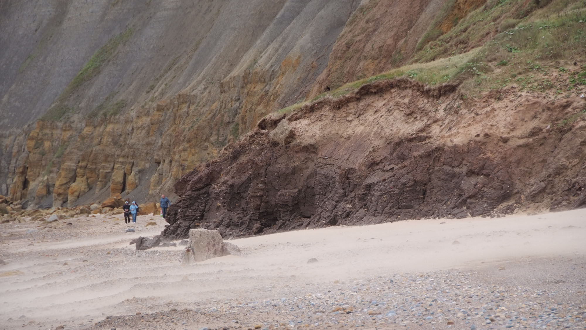
Overview
Directions
- Approach Cayton Bay near Osgodby from the A165, following current beach signs. The former main-road junction directions predate changes to the road layout.
- The parish council describes beach entrances past the surf shop and cliff-top car park, and via the small café/public toilets. Use the signed public route; the descent is steep and includes steps.
- A council decision of 29 June 2026 supported an expression of interest for replacement-step funding. This does not establish that replacement steps have been completed. Obey barriers and turn back if access is closed or damaged.
- Northern and southern platforms can be explored only when the tide, swell and access allow a safe return; there is no continuous all-tide route around the headlands.
- Approximate locality reference: 54.24195°N, 0.35709°W. This is not a verified parking or cliff-descent pin.
Location photographs
Swipe to browse · Select a photograph to enlarge


Fossil Hunting
Begin with naturally weathered loose material on the accessible shore. Note the matrix and exact find position before assigning a fossil to a formation: sand, slipped clay and transported blocks can obscure the local succession. Low-tide exposure alone does not make the platforms safe.
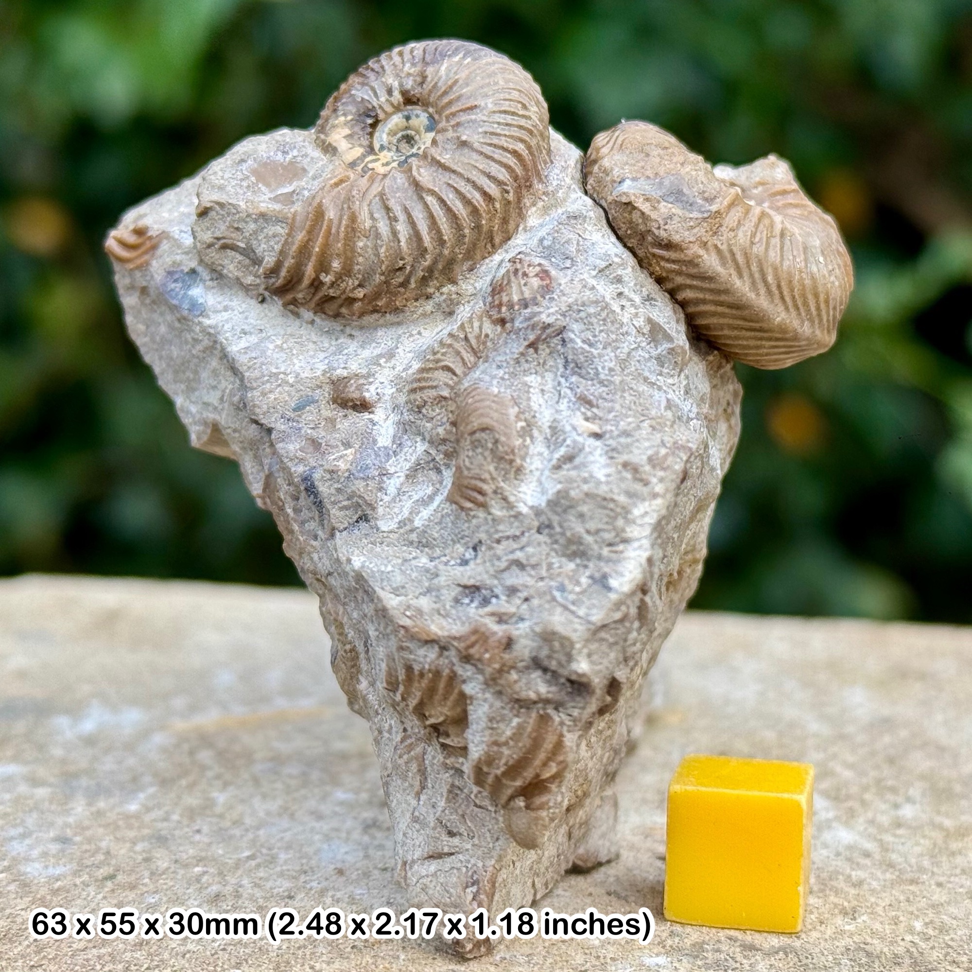
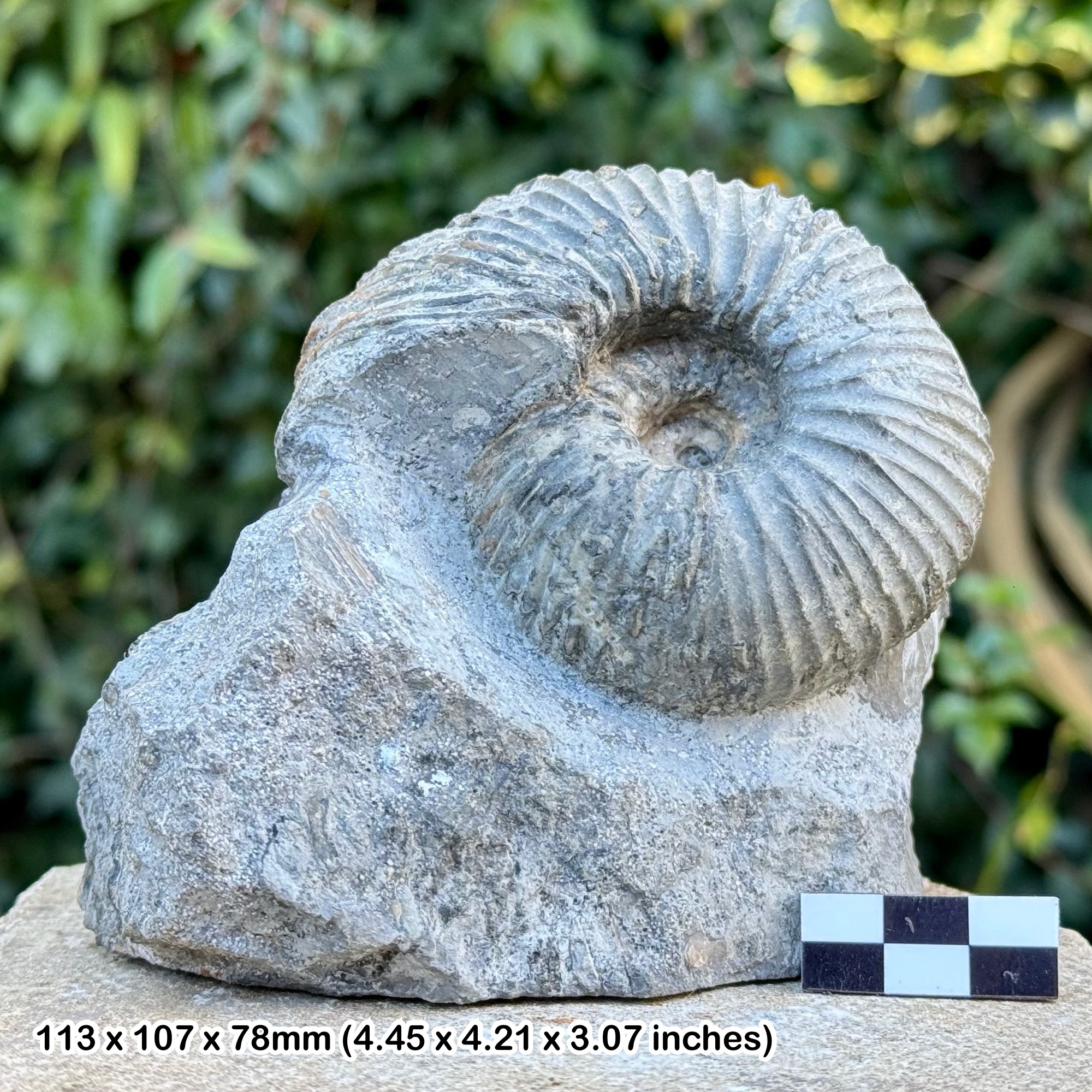
The Tenants’ Cliff Member concretions are especially important for well-preserved bivalves, brachiopods, gastropods and ammonites. Many concretions are barren, and similar matrices mean that loose material cannot reliably be allocated to individual numbered beds. Leave fixed concretions and the cliff undamaged.
Cayton Clay and younger marine beds provide other fossil-bearing material, but a loose nodule should not automatically be labelled Oxford Clay. The old name Macrocephalites refers to an ammonite, not a shrimp. Historical exceptional specimens document the site’s scientific importance without guaranteeing similar modern finds.
Photograph promising finds before preparation, retain associated fragments and record whether the specimen was loose. Unusual fossils or associations should be discussed with a suitable museum specialist before any extraction or extensive preparation.
Fossil photographs
Swipe to browse · Select a photograph to enlarge
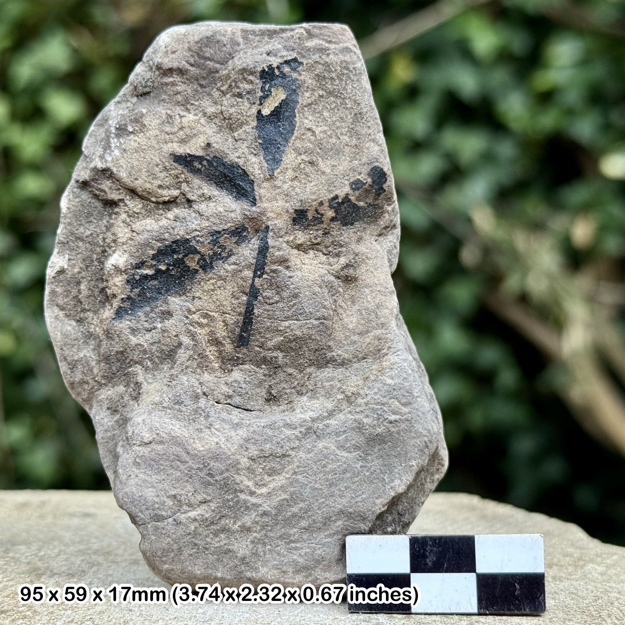
Discoveries and milestones
A chronological record of discoveries, research and conservation at Cayton Bay.
1935–1948 – Historic ammonites documented, provenance later clarified
Arkell’s monograph figured exceptionally preserved ammonites from old Scarborough collections. Several holotypes, including Cardioceras bulbosum, C. tumescens and Goliathiceras globulus, have explicit Cayton Bay provenance in the later review. Other specimens were attributed to Tenants’ Cliff by their matrix, a less certain form of evidence.
1967–1969 – Tenants’ Cliff fossil source rediscovered
A Geologists’ Association visit in 1967 rediscovered the fossiliferous exposure; Penney and Rawson reported ammonite nuclei in 1969. The site helped explain older museum material that had been assigned to the wrong concretion horizon.
1968 – Faulted bedrock mapped
Wright’s geological mapping clarified the solid Jurassic outcrops at Tenants’ Cliff, rather than treating the entire area as landslip over Oxford Clay. The map is a geological interpretation, not a present-day slope-stability assessment.
1983 – Tenants’ Cliff and Saintoft members distinguished
Wright named the older Tenants’ Cliff Member and separated it from the younger Saintoft Ball Beds. The published six-bed section and ammonite fauna underpin the locality’s importance for the Bukowskii Subzone.
1984 and 1994 – Coastal geological interest protected
Cayton, Cornelian and South Bays SSSI was first notified in 1984; the formal citation records a revision on 4 February 1994. The designated coast includes scientifically important Jurassic sections beyond the immediate Cayton guide.
1989 – Peak Trough structure reassessed
Milsom and Rawson described the Peak Trough as a major control on the coastal geology. The fault system explains juxtaposed successions, but faults should not be conflated with every depositional unconformity.
2006–2008 – Landslide processes investigated
A 2006 geomorphological study distinguished the bay’s landslide complexes. BGS investigated the April 2008 Knipe Point movement, reinforcing the importance of active coastal instability for access and conservation.
2014 – Ammonite damage investigated
Wright, Bassett-Butt and Collinson studied 266 cardioceratid ammonites from Tenants’ Cliff and interpreted characteristic shell damage as evidence of fatal attacks. The identity of the predator remains tentative. This is the study’s publication date, not a date assigned to all collecting.
Geology
Cayton Bay is a set of faulted and partly landslipped Middle and Upper Jurassic exposures rather than one continuous Callovian rock column. Osgodby Nab, the waterworks foreshore, Tenants’ Cliff and High Red Cliff each contribute a different part of the geological story; measured thicknesses from them must retain their locality labels.
Cornbrash limestone is followed by the Cayton Clay Formation and the sandstone-rich Osgodby Formation, with marine mudstone and younger calcareous sandstone represented elsewhere in the bay. Fossils and sedimentary structures record changing shallow-marine conditions. The Oxfordian Tenants’ Cliff Member belongs to the Lower Calcareous Grit Formation and includes the celebrated fossil-bearing concretions.
Faults shift the levels at which units reach the shore, while landslips, superficial deposits and mobile beach sand can conceal or move the rocks. These processes must be distinguished from genuine stratigraphic gaps. The Filey Brigg Hambleton Oolite–Birdsall succession should not be transferred to Cayton Bay.
The detailed account below keeps the six-bed Tenants’ Cliff log separate from the older alpha and beta schemes at Red Cliff and Osgodby. It also retains the unresolved difference between published Redcliff Rock thicknesses instead of combining them into an artificial measured section.

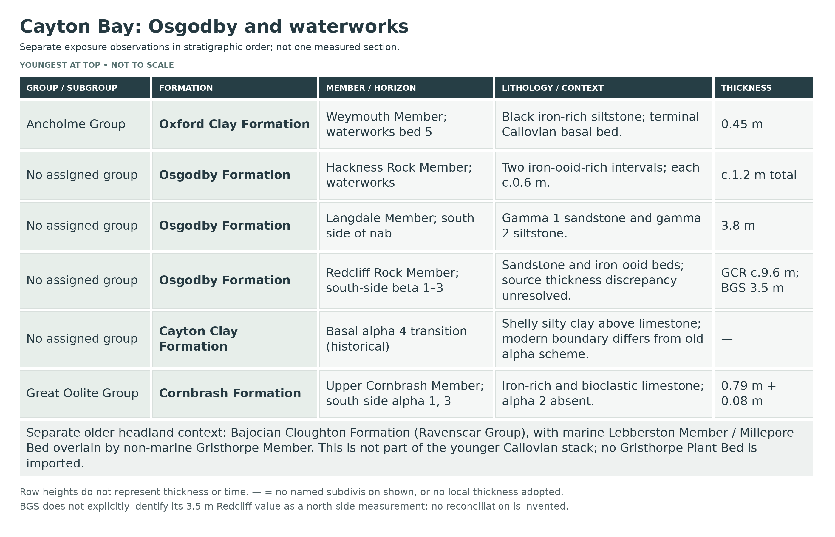
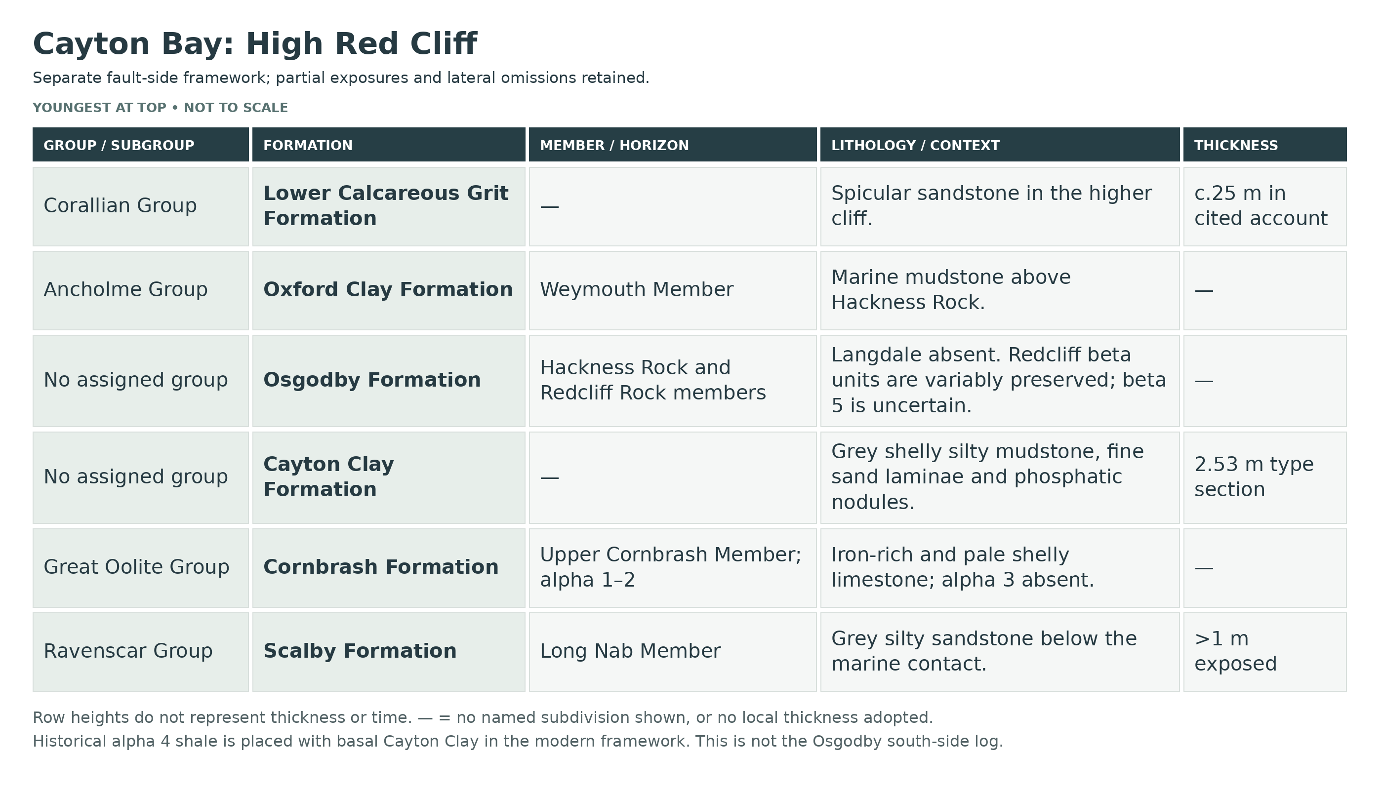
Detailed geology and bed-by-bed succession
Detailed geology and fossil-bearing horizons at Cayton Bay.
A faulted bay, not one uninterrupted log
The bay combines different fault-bounded exposures, with Middle Jurassic rocks at Osgodby Nab, Callovian marine beds around the nab and Red Cliff, and Oxfordian strata at Tenants’ Cliff. The numbered Tenants’ Cliff beds, Greek-letter Osgodby subdivisions and waterworks bed numbers belong to different published logs and must not be merged. Beach cover changes what can be seen.
RAVENSCAR GROUP
Cloughton Formation — Osgodby Nab
Bajocian rocks at the nab include the marine Lebberston interval and overlying non-marine Gristhorpe beds. They are geographically separate from much of the younger marine succession described below.
Lebberston Member
The traditional Millepore Bed is a calcareous marine sandstone/limestone interval within this member, not a separate formation. Bryozoan-rich rock is recorded at Osgodby Nab. The much fuller Yons Nab log should not be transferred here.
Gristhorpe Member
Sandstone and finer non-marine beds overlie the marine Lebberston interval at the nab. The classic Gristhorpe Plant Bed farther east is not established as a collectable plant bed at this exact exposure by these sources.
Scalby Formation — High Red Cliff
The top of the Bathonian succession appears beneath the younger marine beds at High Red Cliff. This is a different fault-side exposure from the Cloughton rocks at the low headland.
Long Nab Member
At High Red Cliff, more than 1 m of grey silty sandstone is exposed immediately beneath the Cornbrash. Burrows descending from the marine contact include Rhizocorallium. This partial exposure does not represent the full Scalby succession.
GREAT OOLITE GROUP
Cornbrash Formation
Upper Cornbrash Member
The local Cornbrash is Lower Callovian, rather than the Bathonian Lower Cornbrash of southern England. The historical Fleet Member name is superseded by Upper Cornbrash. Published alpha subdivisions vary laterally.
Osgodby Nab south side: alpha 1, alpha 3 and the upper transition
Alpha 1 is 0.79 m of red-weathering berthierine-ooid-bearing limestone with bivalves and rare Macrocephalites. Alpha 2 is absent. Alpha 3 is only 0.08 m of sandy bioclastic limestone with reworked ooidal pebbles, Lopha marshii and the ammonite Macrocephalites kamptus. Alpha 4 is the shelly silty transition assigned in this account to basal Cayton Clay; Meleagrinella, Lopha and Nanogyra occur.
High Red Cliff: a different alpha succession
At High Red Cliff alpha 3 is absent. The comparative coastal log describes alpha 1 as 0.14–0.37 m of iron-rich limestone, alpha 2 as about 0.15 m of pale, shelly limestone with variable ooids, and alpha 4 as a thin silty or sandy shale transition. These ranges belong to the published coastal comparison, not a newly measured constant section. The historical scheme included alpha 4 in Cornbrash; the modern limestone-to-shelly-mudstone boundary places the transition with basal Cayton Clay.
Younger Callovian formations without an invented group
Cayton Clay and Osgodby are formations; the BGS Lexicon does not assign either to a parent group. The Great Oolite bar above applies to Cornbrash only.
Cayton Clay Formation
Dark marine silty clay succeeds the Cornbrash; Red Cliff is the type section. Phosphatic nodules and shelly material occur locally. At Osgodby Nab, Macrocephalites polyptychus is recorded from scattered nodules. Macrocephalites is an ammonite, not a shrimp. Crustacean records must retain their exact north-side or formation-wide scope rather than being assigned to every nodule on the beach. At the Red Cliff type section BGS records 2.53 m of grey shelly silty mudstone with very fine sandstone laminae and phosphatic nodules; this precise published type-section value is not substituted for other authors’ approximate measurements.
Osgodby Formation
A sandy marine succession, subdivided into Redcliff Rock, Langdale and Hackness Rock members. Different parts are omitted or strongly condensed at different exposures. Regional thicknesses and the measurements on opposite sides of Osgodby Nab cannot be combined into a single bay log.
Redcliff Rock Member
At the south side of Osgodby Nab the GCR describes about 9.6 m in beta 1–3; berthierine-ooidal beta 2 includes Kepplerites and Proplanulites. BGS gives 3.5 m of Redcliff Rock in its Osgodby Nab type-section account. The discrepancy remains unresolved: the BGS text does not explicitly identify a north-side measurement, so the values cannot simply be reconciled by assuming opposite sides of the nab.
High Red Cliff beta 1 — pale sandstone
Pale yellowish sandstone, up to 6.85 m in the comparative coastal description, grades from the Cayton Clay. Hard calcareous concretions reach 0.60 m across. Fossils are sparse outside some concretions, with small fragmentary bivalves including Meleagrinella; Kepplerites is recorded near the top.
High Red Cliff beta 2 — iron-ooid sandstone
Berthierine-ooidal sandstone, up to 2.35 m in the coastal account, has a richer fauna including Entolium, Liostrea, Modiolus, Cadoceras, Kepplerites, Proplanulites and rare Chamoussetia. Rusty weathering helps distinguish it from the paler basal sandstone.
High Red Cliff beta 3 — less ooidal sandstone
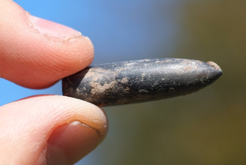
Fossiliferous sandstone, non-ooidal or only sparsely ooidal, reaches a published coastal maximum of 1.98 m. The more varied bivalves include Chlamys, Oxytoma and Trautscholdia; ammonites and occasional possible cylindroteuthid belemnites also occur. These maxima are not a constant thickness at every point.
High Red Cliff beta 4 and possible beta 5
Impersistent pale-weathering berthierine-ooidal sandstone, beta 4, reaches 0.55 m and contains shelly concretions with small bivalves and rare possible Proplanulites. A possible beta 5 soft sandstone, up to 0.65 m, remains uncertain. Neither unit should be drawn as continuously present across the bay.
Langdale Member
On the south side of Osgodby Nab the 3.8 m member includes gamma 1 fine- to medium-grained sandstone with clay wisps and bivalves including Chlamys and Modiolus, followed by gamma 2 flaggy-weathering siltstone with rare bivalves, belemnites and Erymnoceras. The member is absent at High Red Cliff.
Hackness Rock Member
Condensed iron-ooid-bearing marine beds occur at several separate exposures. The 0.75 m north-side Osgodby log is not a measured thickness for the south side. High Red Cliff has a hard greenish iron-ooid-bearing unit above its truncated older Osgodby succession.
Waterworks foreshore: lower and upper Hackness Rock
At the waterworks exposure, the lower approximately 0.6 m is hard berthierine-ooidal sandstone with Kosmoceras and Binatisphinctes. The upper approximately 0.6 m is ooidal sandstone/oolite yielding Quenstedtoceras, Peltoceras (Peltomorphites) and Hecticoceras. These are local observations, not thicknesses for every Hackness Rock outcrop.
ANCHOLME GROUP
Oxford Clay Formation
Weymouth Member
Upper Oxford Clay in the Cleveland Basin straddles the latest Callovian–earliest Oxfordian interval. Its presence does not mean every fossil found loose in Cayton Bay came from Oxford Clay. The sandy Osgodby beds lie beneath it in normal stratigraphic order.
Waterworks basal Oxford Clay: published Bed 5
A 0.45 m black iron-rich siltstone with calcareous nodules yields Quenstedtoceras paucicostatum and possible Longaeviceras. This is terminal Callovian evidence, not proof of the Oxfordian boundary at that bed. The basal Oxfordian Scarburgense interval is expected in the succession but was not specifically fossil-confirmed in this account.
Transition to the Lower Calcareous Grit
The change from muddy Oxford Clay to sandy, sponge-spicule-rich sediment is gradual. At Tenants’ Cliff the lowest numbered bed is still strongly muddy; the lithological formation boundary is not a sharp, universally recognisable surface.
CORALLIAN GROUP
Lower Calcareous Grit Formation
At Tenants’ Cliff the traditional “grit” is largely sandy siltstone, with abundant sponge spicules. Slow accumulation and early concretion growth helped preserve delicate shells. High Red Cliff has a separate higher-cliff exposure: the YGS account describes about 25 m there, not a complete measurement of the Tenants’ Cliff log.
Tenants’ Cliff Member
These are the older fossiliferous concretion beds, distinct from the younger Saintoft Ball Beds. Many historical museum specimens labelled simply “Scarborough Ball Beds” were later traced or inferred to originate here; label uncertainty must not be erased.
Tenants’ Cliff Bed 1 — seen to 3.63 m
Soft argillaceous sandy siltstone becomes more spicule-rich upwards. The published sample contains 73% silt and clay, supporting the alternative placement of its lowest part in Oxford Clay. Cardioceras praecordatum places it in the Praecordatum Subzone.
Tenants’ Cliff Bed 2 — 2.15 m
Moderately bedded, slightly sandy spicular siltstone has clayey partings and four rows of calcareous concretions, some reaching about 1 m across and 0.5 m thick in the measured section. The dimensions describe observed concretions, not a collection target.
Tenants’ Cliff Bed 3 — 7.97 m
Massive muddy, sandy spicular siltstone contains frequent smaller concretions. Loose concretions from beds 2 and 3 have similar matrix and cannot reliably be assigned to one of those beds. Many are barren or contain bivalves rather than ammonites.
Shared beds 2–3 fauna
Recorded shells include Chlamys fibrosus, Nanogyra nana and Pleuromya uniformis, the brachiopod Rhynchonelloidella thurmani, and the gastropod Alaria cf. laevigata. Cardioceratid ammonites indicate the lower Bukowskii Subzone. Articulated bivalves and finely preserved ammonites reflect early protection within concretions; their historical abundance is not a promise of a find on each visit.
Tenants’ Cliff Bed 4 — 2.36 m
Massive fine sandstone, with sporadic sponge spicules, contains many sediment-filled Thalassinoides burrows. Its sandier character contrasts with the muddier beds below.
Saintoft Member
The younger Saintoft beds cap the measured Tenants’ Cliff succession. The famous large Ball Beds concretions seen at Filey are not exposed in this Cayton section.
Tenants’ Cliff Bed 5 — 0.80 m
Fine sandstone grades upward into sandy micritic limestone. Loose blocks assigned to this bed have yielded Pachyceras, Cardioceras and Myophorella triquetra.
Tenants’ Cliff Bed 6 — seen to 0.9 m
Brown, fine-grained, strongly spicular sandstone is the highest bed in the published measured section; its exposed thickness is not the full Saintoft Member.
Quaternary cover and active landslides
Till and landslide debris obscure and mix the Jurassic outcrops. The Knipe Point and Cayton Cliff instability demonstrates why an old description of a particular bedrock exposure as stable cannot be turned into a modern assurance about the cliff or access route.
References
UK Fossils: Cayton Bay (last visited 2011)
Wright & Cox (2001): Tenants’ Cliff, Cayton Bay, GCR 21
Cox & Sumbler (2002), Gristhorpe Bay and Osgodby Nab, GCR 26, pp.324–335
Martin Whyte & Mike Romano (2006): Middle–Upper Jurassic sequence between Cayton Bay and Yons Nab
BGS Lexicon: Cayton Clay Formation
BGS Lexicon: Osgodby Formation
BGS Lexicon: Lower Calcareous Grit Formation
BGS Lexicon: Upper Cornbrash Member
Natural England: Cayton, Cornelian and South Bays SSSI citation
BGS: Knipe Point, Cayton Bay landslide case study
Fish et al. (2006): Landslide geomorphology of Cayton Bay
BGS Lexicon: Oxford Clay Formation
BGS Lexicon: Lebberston Member
BGS Lexicon: Scalby Formation
Safety
Tides and swell can isolate platforms and headlands. Check tide times and the weather before setting out, plan the return route and retreat early if conditions worsen. Do not use a damaged or closed descent.
Keep well clear of cliff feet, overhangs and landslip faces, particularly after rain or storms. Mud, seaweed and uneven boulders can be slippery. Do not climb or dig the cliffs; a helmet does not make an unstable face safe.
Equipment
Wear grippy sturdy footwear and carry tide information, a phone, hand lens, notebook or camera, wrapping and rigid containers. Observation and permitted loose finds are preferable to tools that damage fixed exposures.
Cleaning And Treating
Support wet clay-bound shells and allow them to dry slowly. Do not routinely wash fragile material or force shells from hard concretions; delicate shell edges can extend unexpectedly into the matrix.
Begin with minimal dry cleaning of stable material. Avoid acids, aggressive power tools and routine varnish. Keep pyritic specimens dry and inspect them for cracking or powdering; leave significant specimens unprepared for specialist advice.
Identify Your Finds
Need help identifying a fossil? Share clear photos, where you found it and its size with the community.
Further Reading
Wright & Cox (2001): Tenants’ Cliff, Cayton Bay, GCR 21
Cox & Sumbler (2002), Gristhorpe Bay and Osgodby Nab, GCR 26, pp.324–335
Martin Whyte & Mike Romano (2006): Middle–Upper Jurassic sequence between Cayton Bay and Yons Nab
BGS Lexicon: Cayton Clay Formation
BGS Lexicon: Osgodby Formation
Natural England: Cayton, Cornelian and South Bays SSSI citation
Visit North Yorkshire: Cayton Bay
North Yorkshire Council: Cayton Bay access steps decision, 29 June 2026
BGS: Knipe Point, Cayton Bay landslide case study
Wright, Bassett-Butt & Collinson (2014), Fatally bitten ammonites
Access Rights
Cayton, Cornelian and South Bays SSSI protects a wider coast than this guide’s core locality. Designation does not itself grant access or collecting permission. Follow current landowner and site-management rules, conserve fixed exposures and leave important in-situ specimens undisturbed. The original linked SSSI citation explains the scientific interest.
It is important to follow our ‘Code of Conduct’ when collecting fossils or visiting any site. Please also read our ‘Terms and Conditions’.
Links
♦ Fossil Discussions
♦ Fossil Articles
♦ Buy Fossils, Tools and Equipment
♦ Buy Crystals, Meteorites, and Artefacts
♦ Join Fossil Hunts
♦ UK Fossils Network


