

Crakaig’s Jurassic foreshore is a rocky, seaweed-covered shore north of the campsite, with striking sedimentary boulder beds and occasional exposures of finer fossil-bearing rock. The original visit recorded ammonites and shells, but sand and shingle often conceal the finer beds. This is a demanding shore where changing exposure matters more than a particular season.


FIND FREQUENCY: ♦♦ – The original account records ammonites and shells, but productive finer beds are only intermittently uncovered.
CHILDREN: ♦ – Unsuitable for young children: the uneven, slippery foreshore and uncertain finds make this a demanding visit.
ACCESS: ♦♦ – A narrow approach through the campsite area leads to a rocky tidal shore. Arrange vehicle access and parking locally.
TYPE: Foreshore and low coastal outcrops, with sedimentary boulder beds, finer interbeds and variable beach cover.
DIRECTIONS
♦ From the A9 south of Helmsdale, locate the small hamlet of Crakaig between Lothbeg and Lothmore. This guide uses the southern Crakaig hamlet, not Crakaig Crofts farther north.
♦ The established approach is the small road descending towards the coast and passing beneath the railway bridge. It is narrow and single-track, with campsite traffic. Check the bridge’s available clearance and current vehicle-access arrangements before driving down; do not assume it is suitable for a high vehicle.
♦ Beyond the bridge, the original route bends left, then turns sharply right downhill towards the campsite and shore. Ask locally where day visitors may park, keep the track clear and follow any current signs. The old instruction to park beside caravans is not a standing parking permission.
♦ On reaching the shore, head north. The original shore reference is 58.06725°N, 3.74830°W, approximately NC 9696 1002. This is an outcrop reference, not a parking point.
♦ Plan around low tide and allow ample time to return. The scientific section called ‘Crackaig Links’ beside Lothbeg Point lies about a kilometre south-west of this shore reference and is a different exposure.
FOSSIL HUNTING
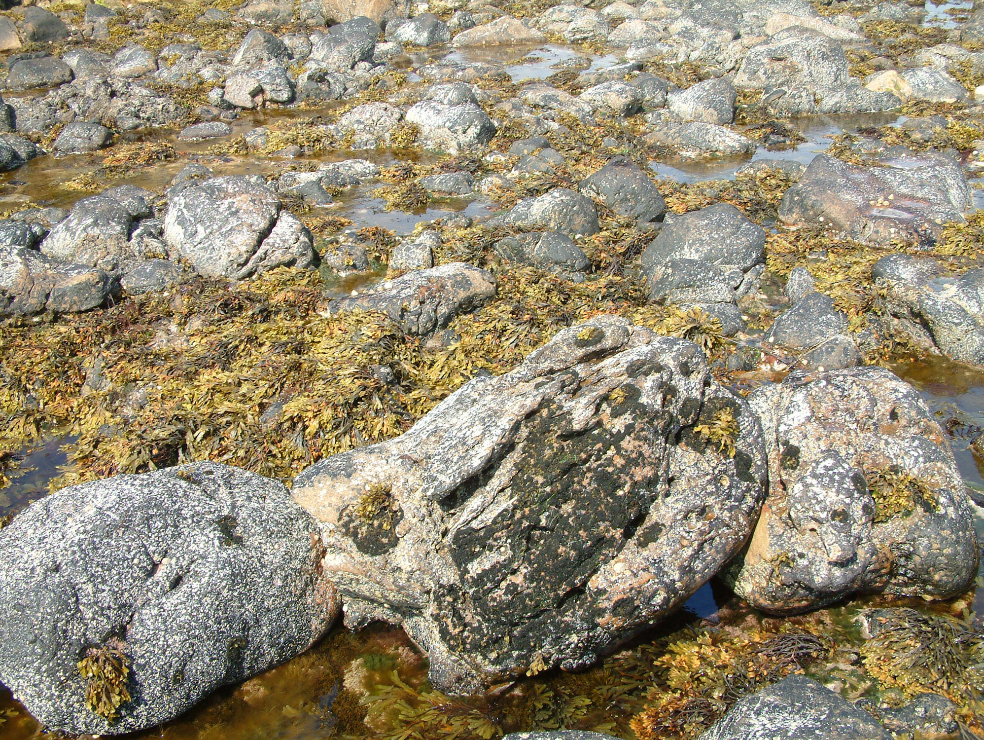
Start by looking for naturally uncovered fine-grained rock between the more resistant outcrops. Much of the shore can be hidden beneath sand, rounded stones, pools and seaweed, as the original photographs show. A scour may reveal surfaces that were buried on a previous visit, but a visit in winter or spring does not guarantee useful exposure. If the finer beds remain covered, the large sedimentary blocks still make the shore worth studying without disturbing the beach cover.
The original Crakaig visit account reports ammonites and shells in these intermittent exposures, without a specimen list or securely documented species. Look closely at naturally weathered surfaces for coiled outlines, ribs or impressions, and for curved shell fragments embedded in the rock. A hand lens and photographs are more useful for an uncertain fragment than breaking it to reveal more. Modern shells and pale encrusting growth are also present on the shore; an attached shell on a seaweed-covered surface is not, by itself, evidence of a Jurassic fossil.
Keep three settings separate when examining a possible find: fine interbeds still attached to the outcrop, the matrix surrounding the large blocks, and loose stones in the shingle. A loose piece may have moved along the beach, while an older block enclosed within the Jurassic deposit can retain an earlier geological history. Photograph the surrounding rock as well as the object, add a scale and record its position and whether it was loose or in place. These details can be more informative than an unsupported species name.
The northern boulder beds are sedimentary deposits, rather than the general volcanic sequence described in the old guide. Their large sandstone and flagstone blocks record the collapse and transport of older rock beside a Jurassic fault margin. They are useful geological features in their own right, but their presence does not establish that every block contains fossils. The well-documented rich ammonite and plant assemblages from ‘Crackaig Links’ at Lothbeg Point should not be expected automatically on this northern route.
A museum collection provides a more specific record from the wider Crakaig locality: a short articulated series of ichthyosaur vertebrae collected by Michael Dudgeon in 1995 is documented at Timespan in Helmsdale. Its published provenance is ‘Crakaig, Loth’, without an exact shore position or bed. It confirms a notable marine-reptile find from the named locality, but cannot be assigned specifically to this northward route or treated as a likely find here.
Examine and photograph existing surfaces without stripping seaweed, digging through beach deposits or breaking protected outcrops. Obtain the relevant landowner or mineral-rights permission before taking specimens, and check the site-specific conservation requirements below. Leave a potentially significant find in place while recording it and seeking specialist advice, unless an appropriately authorised recovery has been arranged.

A chronological record of geological and conservation milestones for the northern shore, with a separately qualified fossil discovery from the wider Crakaig locality.
1963 – First notification of the wider coastal SSSI
The larger Brora–Helmsdale Coast site was first notified for conservation. This is the origin of the designation history of today’s Helmsdale Coast SSSI; its present coastal boundary should not be assumed to reproduce the original 1963 boundary exactly.
1986 – Helmsdale Coast re-notified
The Helmsdale Coast SSSI was re-notified on 12 December with a reduction in area. The designated coastal outcrops include the Crakaig tract and protect the scientific interest of the Jurassic succession.
1995 – Ichthyosaur vertebrae collected at Crakaig
Michael Dudgeon collected a short articulated series of ichthyosaur vertebrae, subsequently documented in the Timespan collection. The recorded locality is Crakaig, Loth; the exact shore position and bed are not given, so the specimen cannot be placed specifically on the northern route covered by this guide.
2011 – Protected-site documents reviewed
The notification documents were reviewed on 2 February. The citation, boundary map and site-specific operations requiring consent provide the conservation framework for the shore’s geological exposures.
2014 – Sutherland Group framework revised
A. J. M. Barron and J. B. Riding set out a revised formation-level framework for the coastal Jurassic rocks. Their map places the northern Crakaig tract within the Helmsdale Boulder Beds Formation, while distinguishing the neighbouring sandstone and boulder-bed formations.
GEOLOGY
Crakaig lies along the margin of a Jurassic marine basin beside the Helmsdale Fault. Movement on this fault system created a steep submarine slope from which sediment and pieces of older rock could collapse into deeper water. The northern shore is mapped in the Helmsdale Boulder Beds Formation of the Sutherland Group. Its boulders are components of a sedimentary deposit: the contrast between large blocks and the material around them records transport and deposition, rather than a succession of lava flows.
At the north end of Crakaig Bay, published field descriptions record orange-weathering sandstone blocks, reaching about a metre across, enclosed in a similar sandy matrix. Rockfall beside a subsidiary fault has been proposed as their origin. A Devonian flagstone clast is also documented close to the original guide point. Such a block is older than the Jurassic deposit that contains it; its internal layers are not a separate younger formation or a thickness measurement of the boulder bed.
Finer sedimentary rocks occur around the bay as well. The bay-centre description, south-west of the original northern shore point, records thinly layered siltstone or shale and pale sandstone, with erosive bases and beds that thin sideways. These quieter-water deposits contrast with the coarse debris arriving from the fault margin. However, the regional account of the Helmsdale Boulder Beds describes sandstone and siltstone interbeds rather than true black shale. The old guide’s blue ‘Kimmeridge Clay’ should therefore be treated as an informal field description, not a verified identification of the Kimmeridge Clay Formation.
The beds are Upper Jurassic, within the Kimmeridgian coastal succession, but neither the old numerical age range nor a neighbouring measured log can date every rock exposed here. Folding, faulting, lateral changes and gaps beneath the modern beach complicate a simple walk through the sequence. The chart shows the supported local framework and distinguishes the northern boulder-bed exposure from the bay-centre finer facies; it is not a measured vertical section.

Detailed geology of the northern Crakaig shore, its sedimentary boulder beds and the separate bay-centre finer facies.
This account follows the original northward route from the campsite to approximately NC 9696 1002. The lower fine-grained scientific section called ‘Crackaig Links’, near NC 961 095 beside Lothbeg Point, lies about a kilometre to the south-west. Its measured beds, concretion horizons, ammonite zones and plant assemblages are not a log of the northern Crakaig shore.
SUTHERLAND GROUP
The local Jurassic rocks belong to the Sutherland Group. The revised 2014 framework recognises the Helmsdale Boulder Beds, Allt na Cuile Sandstone and Kintradwell Boulder Beds as separate formations; the latter two are approximately coeval in that regional scheme. They should not be assembled into three obligatory successive layers at Crakaig. The group’s regional thickness is not the thickness visible on this shore.
Helmsdale Boulder Beds Formation
The geological maps place the relevant northern coastal tract in this formation. Its wider outcrop contains coarse debris deposits interdigitating with sandstone and siltstone. Regional structures include gentle folds and minor faults, so outcrop position alone does not establish a complete upward succession. The modern beach exposes only parts of this framework, and no secure measured section or formal member boundary has been established for the original guide’s northern point.
Northern sandstone-block facies
At the north end of the bay, the recorded orange-weathering boulder beds contain sandstone clasts up to about 1 m across within a similar sandy matrix. This is a clast dimension, not the thickness of a bed. The published interpretation is rockfall debris beside a splay of the fault system. Neither that interpretation nor the colour of weathered rock fixes a surveyed contact, and not every dark rock along the coast can be identified from a photograph.
Older flagstone within the Jurassic deposit
A Devonian flagstone clast has been documented at NC 9690 1003, close to the original shore reference. The older rock was incorporated into the younger sedimentary deposit. Layering retained inside such blocks belongs to their earlier history; it must be distinguished from the bedding and age of the surrounding Jurassic matrix. The original photographs include large internally layered blocks, but they do not independently establish the exact position or age of each photographed block.
Bay-centre laminated facies, south-west of the northern point
The recorded bay-centre succession contains finely laminated siltstone or shale with white sandstone interbeds on a millimetre-to-decimetre scale. Sandstone beds have erosive bases and can thin laterally; boulder beds appear abruptly farther along the bay. The reported absence of bioturbation supports a low-oxygen bottom-water interpretation. These are descriptions of facies and their lateral changes, not named beds or a measured total thickness, and their exact contact with the northern exposure has not been surveyed here.
Fine-grained terminology and fossil evidence
The regional description between Crackaig and Dun Glas distinguishes interbedded sandstone and siltstone from true mudstones or black shales. This contrasts with looser use of ‘shale’ in bay descriptions and ‘Kimmeridge Clay’ in the original guide. Fine grain size and blue-grey colour alone do not identify a formation. Ammonites and shells are retained as qualified observations from the old visit account; no bed-specific genus, species or reptile record is established for this northern route.
Historical ranks, age and unresolved contacts
Older accounts and map indexes use Allt na Cuile Sandstone, Kintradwell Boulder Beds, Lothbeg Shale and Portgower Boulder Beds member terminology. These names belong to different stratigraphic treatments, not four extra beds to place beneath the northern outcrop. The newer formation-level framework is used here, without assigning unverified member contacts. Regional Upper Kimmeridgian terminology in older British literature also extends into intervals treated as Tithonian in modern usage; it does not establish the age of every Crakaig exposure. No numerical age, local thickness or detailed zonal sequence is inferred.
Modern beach cover
Sand, shingle and seaweed can conceal the finer rocks while leaving the more resistant outcrops conspicuous. This changing cover belongs to the modern shore and is not another Jurassic member. It explains why the original fossil observations depended on scouring and why a later visit may reveal a different amount of rock.
References
Barron, A. J. M. and Riding, J. B. (2014), A revision of the Jurassic (Bathonian to Oxfordian) lithostratigraphy of the onshore Moray Firth Basin, north-east Scotland, Table 2 and Figure 2.
Cox, B. M. (2001), Helmsdale account, in British Upper Jurassic Stratigraphy, Geological Conservation Review Series 21, especially Figures 5.9–5.10 and the Crackaig–Dun Glas description.
Scottish Geology Trust, Crakaig Bay geosite account, description of the bay-centre facies, northern boulder beds and flagstone clast.
MacDonald, A. C. and Trewin, N. H. (2009), Upper Jurassic of the Helmsdale area, itinerary 3.2, for the separate Lothbeg Point locality and shared approach.
SAFETY
Check the local tide times and sea conditions before setting out. The tide reaches high up this beach and can restrict the return around rocky projections. Work on a falling tide where practicable, keep the return route in sight and leave well before rising water removes it. Avoid the shore in rough conditions; a predicted low tide does not remove wave danger.
Seaweed, algae, wet rock and loose stones make footing unreliable. Wear boots with good grip, move slowly around pools and avoid standing on unstable blocks or beneath loose coastal faces. The narrow campsite track and railway underpass also need care around vehicles. Use the underpass, never the railway itself, and follow local access instructions.
EQUIPMENT
Bring a hand lens, camera, scale, notebook, tide information and sturdy footwear. A small rigid box and soft wrapping are useful only for specimens you have permission to remove. The original recommendation to take picks and split the rocks is inappropriate as general advice for this protected shore: observational tools should be the starting point, and any sampling method needs the relevant authority and conservation advice.
CLEANING AND TREATING
For an authorised loose find, keep the locality, date and matrix information with the specimen. Support thin fine-grained pieces so they cannot flex or rub against harder stones. Begin with a soft dry brush on stable material; do not scrub a fragile impression or try to force a shell away from the surrounding rock.
Fine laminated rock can split or crumble when repeatedly soaked and dried. Let wet material dry slowly at room temperature, avoiding heat, and seek advice before desalinating unstable material or attempting consolidation. Do not use household acids, bleach or routine varnish. Leave potentially important material unprepared until a specialist has examined the fossil and its geological context.
IDENTIFY YOUR FINDS
Need help identifying a fossil? Share clear photos, where you found it and its size with the community.
FURTHER READING
Barron and Riding: the revised Moray Firth lithostratigraphical framework
Geological Conservation Review: the Helmsdale coastal succession
Upper Jurassic of the Helmsdale area: regional field guide and the separate Lothbeg Point itinerary
NatureScot: Helmsdale Coast SSSI
National Museums Scotland: Highlands and Islands fossil collections, including Timespan
ACCESS RIGHTS
The relevant Crakaig coastal outcrops are shown within the Helmsdale Coast Site of Special Scientific Interest. Its notified coastal boundary is discontinuous; the published overview map does not settle every path or fine-scale property boundary. Responsible walking access is separate from permission to remove fossils. Obtain the appropriate landowner or mineral-rights permission before collecting, and seek NatureScot advice where sampling or other work could affect the protected features.
The site-specific operations list covers coastal protection works, earthworks and related construction or removal, storage on or against outcrop, and battering, buttressing or grading rock faces. It does not list a separate geological-specimen-removal operation, but that omission is not permission to collect or damage the site. Listed operations may still apply to a proposed activity, and any necessary consent is separate from the owner’s permission. Leave protected rock faces and significant features undamaged.
The latest published sitewide assessments record the Kimmeridgian feature as ‘Unfavourable declining’, assessed on 12 September 2023, and Mesozoic palaeobotany as ‘Favourable maintained’, assessed on 3 May 2023. These assessments describe the wider SSSI’s features; they are not notices closing this route or a general Scottish fossil-collecting ban.
 Scotland’s fossil resource is at risk of abuse and damage, and so we must all safeguard and managed fossil collecting to ensure its survival for future generations. For this reason it is VITAL you read and adhere to the Scottish Fossil Code for ALL sites in Scotland.
It is important to follow our ‘Code of Conduct’ when collecting fossils or visiting any site. Please also read our ‘Terms and Conditions‘
LINKS
♦ Fossil Discussions
♦ Fossil Articles
♦ Buy Fossils, Tools and Equipment
♦ Buy Crystals, Meteorites, and Artefacts
♦ Join Fossil Hunts
♦ UK Fossils Network


