

Belemnites and shell-packed rocks bring the Jurassic shore at Faoilean to life. On the west side of Loch Slapin, sandstone cobbles and outcrops contain bivalves and belemnite fragments, with rare ammonite remains recorded farther north. The shore also introduces the sandstone succession for which this part of Skye is geologically important.


FIND FREQUENCY: ♦♦ – Occasional belemnites and bivalves; the original rating reflects earlier visits, not a guarantee of finds.
CHILDREN: not currently rated – Check the approach and shore conditions before bringing children; the former four-diamond rating has not been revalidated.
ACCESS: not currently rated – The beach approach and parking need a current check.
TYPE: Sandstone outcrops, pebbles and cobbles on a sea-loch shore.
DIRECTIONS
♦ Faoilean lies on the west side of Loch Slapin, beside the B8083 between Torrin and Elgol. From Torrin, follow the road around the head of the loch towards its western shore.
♦ Published locality reference: 57.20860°N, 6.03253°W. This is a general locator from the older guide, not a verified parking entrance or descent point.
♦ Confirm permitted parking and a suitable shore approach locally before setting out. The old guide’s beach route has not been checked recently; do not use passing places for parking or make a new descent through vegetation.
FOSSIL HUNTING
Start with the naturally weathered surfaces of sandstone cobbles and pebbles. Belemnite fragments may appear as short rods or rounded cross-sections within the rock; a cross-section alone can be inconspicuous, so look for the same object continuing across another exposed surface. The original photographs show belemnite cross-sections and fragments enclosed in sandstone blocks. Look and photograph rather than breaking rocks open while collecting permission remains unconfirmed.
Shell-rich rocks are another characteristic find. The older field account describes bivalve-packed material towards the northern side of the bay, including smaller blocks among the cobbles. Morton also recorded bivalves on the shore north of Faoilean. Look for repeated shell outlines, curved shell fragments and ribbed surfaces within the sediment, rather than assuming every pale spot is a complete shell. Weathering may expose the fossils unevenly, and much of the shell material is broken rather than suitable for species-level identification.
Pale quartz-rich sandstone and darker shell-rich layers give useful clues to the rock’s composition. At the separately described northern roadside section, shell sand includes bivalve, crinoid and bryozoan debris. This is evidence for a lively marine environment, but it does not mean that complete crinoids or bryozoan colonies should be expected in every beach stone. A hand lens can reveal the texture of small fragments without removing them.
Ammonites are a less dependable prospect. Morton’s shore record includes a small, indeterminable fragment from higher beds north of Faoilean, so rare ammonite remains are a defensible part of the locality’s story. There is no verified named ammonite species list for the visitor bay. The Dactylioceras recorded in older ironstone at the southern roadside stop belongs to that separate section, described in the expanded geology below.
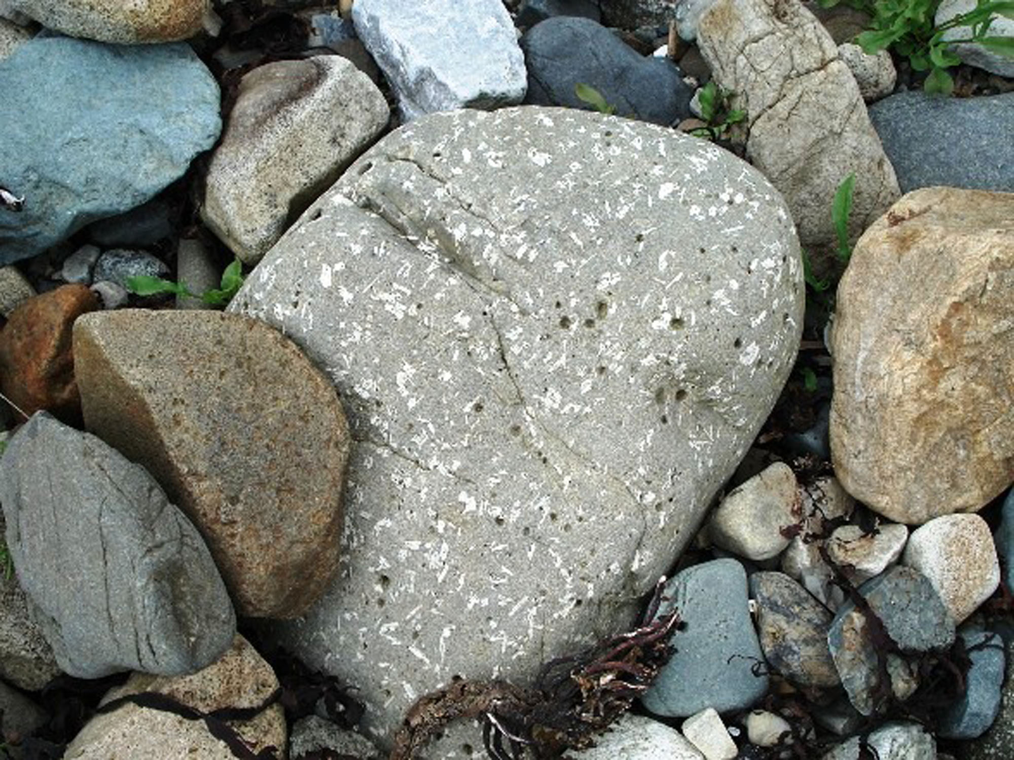
Not every unusual pattern is a fossil. The old photographs include an example of volcanic rock whose markings can be misleading. Compare any suspected shell with a clear biological shape and its surrounding rock; a crack or mineral-filled patch alone is not enough. Traces were reported in the original guide, but their identity is unconfirmed, and the cracked surfaces should not be labelled as fossil “dehydration cracks”. Photograph an overall view and a close-up with scale, recording whether the specimen was loose or still in an outcrop.


A chronological record of significant geological research and stratigraphic milestones at Faoilean.
1965 – Faoilean succession published
Nicol Morton documented the Faoilean sandstone and limestone succession, publishing a measured section and local fossil observations. His account established a detailed basis for comparing the shell-rich and sandstone-dominated intervals in northern Strathaird.
1995 – Northern and southern field sections described
Nicol Morton and John D. Hudson published separate accounts of the roadside sections north and south of Faoilean. The northern exposure illustrated tidal cross-bedding and shell sand; the southern exposure showed older shale and ironstone beneath the sandstone.
2012 – Modern stratigraphic framework synthesised
A national Middle Jurassic framework set Faoilean’s succession within the modern Bearreraig Sandstone Formation and Druim An Fhurain Sandstone Member terminology. It drew on the earlier measurements rather than providing a new measurement of the visitor bay.
GEOLOGY
Faoilean is the type section of the Druim An Fhurain Sandstone Member, a subdivision of the Bearreraig Sandstone Formation. The alternative spelling “Druim an Fhuarain” appears in the older literature. The formation has no parent group in the modern BGS scheme. Its sandstone succession is associated mainly with the Aalenian and Bajocian parts of the Middle Jurassic here, while the formation and member have a broader published Toarcian–Bajocian age range. These geological ages are distinct from the names used to divide the rocks.
The sandstone contains varying proportions of quartz sand and broken marine shells. Where shell debris dominates, the rock becomes a sandy, bioclastic limestone; where quartz dominates, it is pale and hard. Alternating currents moved this mixture into underwater sand waves, leaving inclined layers within the beds. The northern roadside section provides particularly clear published evidence for this tidal interpretation. Its mostly north-directed foresets were measured after allowing for the later tilting of the rocks.
The alternation of shelly and quartz-rich material helps explain why fossils are patchy. Darker shell-rich layers can weather differently from the harder pale sandstone, and loss of carbonate at the surface can disguise their original texture. At the northern roadside stop, the field guide also records local redistribution of calcite into nodule-like remnants and dykes cutting the sedimentary rocks. The loose stones on a beach mix material from different sources, so their position on the foreshore does not establish a precise bed or age.
Morton’s historical Faoilean log records a much larger succession than can be assumed visible in one small bay. It includes basal limestone, a thick sandstone–limestone interval, and an upper shale package. Modern terminology has changed the placement of some boundaries: the basal limestone is included within the sandstone member, while the historical upper package includes Basal Oil Shale belonging to the succeeding Great Estuarine succession. The chart and expanded account keep those distinctions explicit.

Detailed Faoilean stratigraphy, with the historical measured log, separate roadside sections and references.
The historical log is described below from oldest to youngest. It is a published Faoilean succession, not a claim that every interval can be followed continuously around the visitor bay. Its sandstone packages are unnamed lithological intervals: no formal bed numbers or individual thicknesses are assigned where the source supplies none. The two 1995 roadside stops are treated separately afterwards.
Bearreraig Sandstone Formation
This formation is not assigned to a parent group. Bearreraig Bay is its formation type section; Faoilean is the type section of the sandstone member below. The regional formation ranges from the latest Toarcian into the Bajocian, but that range does not date every loose fossil from Faoilean.
Druim An Fhurain Sandstone Member
Morton’s 1965 table separates 20 ft (about 6.1 m) of basal limestone from 762 ft (about 232.3 m) of “Druim an Fhuarain Sandstones”. The modern framework includes the basal limestone within the member. Together those two historical packages amount to 782 ft (about 238.4 m); the 762 ft figure alone must not be presented as an independently measured modern member total.
Basal limestone horizon
Grey, sandy bioclastic limestone forms the base of Morton’s log. The accompanying account describes sandy and shaly partings in the basal limestone. Brachiopods were recorded from this horizon; their comparison with a Mull assemblage led to a tentative historical Scissum Zone correlation. That was a tentative correlation, not a precise modern date for every basal bed.
Thin-bedded sandstone interval
Thin sandstone beds directly overlie the basal limestone in the log. Their distinctly bedded character contrasts with the thicker, more uniform sandstone and limestone units higher in the succession. No separate thickness or numbered-bed scheme is tabulated for this interval.
Massive gritty bioclastic limestone
A substantial shell-rich limestone follows the thin-bedded sandstone. Its gritty character and biological debris distinguish it from the pale quartz-rich units above. The log does not identify a species assemblage confined to this particular package.
First massive pale sandstone and overlying alternation
Above the gritty limestone is a massive whitish sandstone, followed by interbedded pale quartz-rich sandstone and grey sandy limestone. Morton uses “quartzite” for the hard pale rock in the log; here that historical wording describes the sandstone-rich lithology rather than a new formal stratigraphic unit.
Massive light-coloured sandstone
A further massive, light-coloured sandstone interval follows the first sandstone–limestone alternation. It is separately recognisable in the historical log, but no independently tabulated numerical thickness or diagnostic fossil content is supplied for it.
Bedded sandstone with limestone lenticles
The next interval contains pale bedded sandstone with lens-shaped bodies of grey sandy limestone. These lenticles record variation in the distribution of carbonate-rich material within the sandstone package; they should not be assumed to be discrete fossils.
Second massive whitish sandstone
Another massive pale sandstone overlies the lenticle-bearing beds. Its separate position is retained here because it interrupts the otherwise repeated alternations in the measured log. The source does not give it a formal name.
Middle sandstone–limestone alternation
Above this massive sandstone, medium- to dark-grey sandy limestone alternates with pale quartz-rich sandstone. The contrast expresses differing proportions of marine shell debris and quartz sand, rather than a change to a separately named member.
Higher sandstone-rich intervals
The next two labelled packages are both dominated by pale quartz-rich sandstone. The lower includes grey sandy limestone beds and occasional massive sandstone beds; the upper likewise contains some massive sandstone with occasional grey sandy limestone. They are retained as successive intervals without inventing a sharp fossil-zone boundary or separate measurements.
Upper interbedded interval
The top sandstone package returns to interbedded pale quartz-rich rock and grey sandy limestone, with occasional massive sandstone beds. Morton recorded a small, indeterminable ammonite fragment from the upper half of the sandstone succession on the shore north of Faoilean. Its precise placement within these unnamed upper packages is not established.
Across the sandy limestones, Morton describes crinoid, bivalve and bryozoan debris, with belemnites and brachiopods locally. These broad assemblages are not a bed-by-bed species list. Historical bivalve identifications from the shore north of Faoilean have not been revalidated here, and no nearby named ammonite assemblage has been transferred into this section.
Garantiana Mudstone Member
Upper muddy interval and the historical total
Morton’s figure labels an upper dark-grey, micaceous shale interval “Garantiana Clay”, while his thickness table combines Garantiana Shale and Basal Oil Shale as 58 ft (about 17.7 m). The modern Garantiana Mudstone Member belongs at the top of the Bearreraig Sandstone Formation, but the entire historical 58 ft cannot be assigned to that member alone.
GREAT ESTUARINE GROUP — OVERLYING CONTEXT
Cullaidh Shale Formation
The historical Basal Oil Shale is now distinguished within the overlying Great Estuarine succession as the Cullaidh Shale Formation. It is included in Morton’s combined upper 58 ft package, not an extra 58 ft above it. The historical total of basal limestone, sandstone and combined upper shale is 840 ft (about 256 m). BGS repeats the historical Faoilean thickness; this is not a second, independently measured modern Bearreraig total. The exact modern boundary split within the old upper package is not supplied here.
Separate northern roadside section: C1, NG 5639 2073
Morton and Hudson’s 1995 stop C1 exposes lower–middle Bearreraig Sandstone, cut by dykes. Cross-bed sets are mostly less than 1 m thick, bounded by broadly parallel surfaces. Foresets are mainly north-directed after correction for regional tilt. The authors describe thin bedding to near-lamination and a variable mixture of medium- to coarse-grained quartz sand and coarse shell sand of bivalve, crinoid and bryozoan origin.
At C1, shell-poor beds are pale and hard; shell-rich beds are darker and may be decalcified at the surface. Local redistribution of calcite can leave nodule-like shelly remnants. Tidal sand waves reworked the quartz and shell sand. The wider Strathaird pattern includes northerly and southerly palaeocurrents, but the local C1 measurements must not be described as universally bidirectional. The regional interpretation links longshore transport to basin topography potentially influenced by the Camasunary Fault; it is not evidence for a fault plane at the visitor pin.
Separate southern roadside section: C2, NG 5685 1972
The following older succession belongs to the southern roadside stop, not the northern C1 exposure or an identified source of the visitor bay’s loose cobbles. These scientific reference coordinates do not establish a safe or permitted roadside stopping place.
LIAS GROUP — SOUTHERN C2 SECTION
Portree Shale Formation
Incompletely exposed shale
The total shale thickness is not seen at C2. Morton and Hudson estimate it as less than about 2 m, rather than measuring 2 m of complete exposure. BGS also identifies this roadside locality as a reference section for the formation. The unit is Toarcian in age.
Raasay Ironstone Formation
Thin fossil-bearing ironstone
Approximately 1 m of ironstone is recorded at C2, containing Dactylioceras, belemnites and stromatolitic nodules. The local-style ironstone is assigned to the lower Toarcian in the later field synthesis. These fossils and this measurement must remain attached to C2, rather than being promised from the Faoilean beach sandstone.
Bearreraig Sandstone Formation — above the Lias Group at C2
Overlying calcareous sandstone
Normally bedded calcareous sandstone overlies the ironstone, with cross-bedded sandstone at the top of the C2 outcrop. This formation has no parent group: its position above the Lias Group does not make it part of that group. The published C2 description supplies no total thickness for this overlying sandstone.
Limits of the locality account
Scalpay Sandstone is known regionally along western Loch Slapin, but the old guide’s specific slipway attribution has not been independently confirmed. The detailed Keppoch and Dun Liath sections are separate localities, and their named ammonites, individual beds and thicknesses are not included in the Faoilean succession.
References
Morton, N., 1965. The Bearreraig Sandstone Series (Middle Jurassic) of Skye and Raasay. Scottish Journal of Geology 1, 189–216; Faoilean pp. 209–212 and figure 8.
Morton, N. and Hudson, J. D., 1995. Field guide to the Jurassic of the Isles of Raasay and Skye, Inner Hebrides, NW Scotland. In Taylor, P. D. (ed.), Field Geology of the British Jurassic, 209–280; C1 and C2, p. 236.
Barron, A. J. M., Lott, G. K. and Riding, J. B., 2012. Stratigraphical framework for the Middle Jurassic strata of Great Britain and the adjoining continental shelf. BGS Research Report RR/11/06, pp. 130–133.
BGS Lexicon: Bearreraig Sandstone Formation, Druim An Fhurain Sandstone Member, Portree Shale Formation and Raasay Ironstone Formation.
SAFETY
Check tide times, weather and the whole return route before exploring the shore. The older assurance that tidal cut-off is impossible has not been verified. Wet rocks, seaweed and uneven cobbles can be slippery, and shoreline conditions can change. Stay clear of unstable cliff faces and do not climb roadside cuttings to reach a bed.
Take particular care near the single-track road. Keep children close and judge the approach on arrival rather than relying on the old access rating. Tell someone where you are going and when you expect to return; do not rely on mobile reception. Turn back if the descent or return route is uncertain.
EQUIPMENT
Take sturdy footwear with good grip, waterproof clothing, a hand lens, camera, scale and notebook. A map and downloaded tide information are useful where reception is poor. This visit can be rewarding through observation and photography; heavy extraction tools are unnecessary for that purpose. The hard sandstone should not be broken simply to search for an unseen fossil.
CLEANING AND TREATING
For a specimen already held lawfully, record its locality and any known horizon before cleaning. Start with a soft dry brush and leave firmly attached matrix in place. Fragile shell surfaces, impressions and thin flakes can be damaged by scrubbing or forcing the rock apart. Photograph uncertain features before any preparation.
Avoid acids: these can attack shell material and the carbonate cement that holds some of the rock together. Do not routinely varnish or coat fossils. If the specimen is friable, unusually complete or potentially significant, keep it supported and seek preparation advice before soaking, consolidating or using powered tools.
IDENTIFY YOUR FINDS
Need help identifying a fossil? Share clear photos, where you found it and its size with the community.
FURTHER READING
Morton (1965): the Bearreraig Sandstone Series of Skye and Raasay
BGS Lexicon: Druim An Fhurain Sandstone Member
BGS Lexicon: Bearreraig Sandstone Formation
BGS: Middle Jurassic stratigraphical framework
BGS Lexicon: Portree Shale Formation and the southern Faoilean reference section
ACCESS RIGHTS
Obtain the appropriate landowner or rights-holder’s permission before removing fossils. Walking access does not itself grant collecting rights, and permission to collect at Faoilean has not been established. Until it is confirmed, enjoy the rocks through observation and photography.
The published Faoilean reference point lies outside the mapped Strath and Cuillins SSSI boundaries. The full shoreline walk described in the older guide has not been mapped and checked, so this is not a sitewide clearance. Consult NatureScot’s current Strath SSSI information and map before extending your visit.

The reference point is also outside the mapped areas covered by the Skye Nature Conservation Order 2019. The Order applies to specified areas, including Elgol Coast on the other side of the peninsula, rather than all of Skye. This point check does not establish the status of an extended walk or permission to collect.
Follow the Scottish Fossil Code and current local signs. If you encounter an unusual or potentially important fossil, photograph it in place and seek expert advice. NatureScot’s Skye fossil heritage guidance explains the wider island context.
It is important to follow our Code of Conduct when collecting fossils or visiting any site. Please also read our Terms and Conditions.
LINKS
♦ Fossil Discussions
♦ Fossil Articles
♦ Buy Fossils, Tools and Equipment
♦ Buy Crystals, Meteorites, and Artefacts
♦ Join Fossil Hunts
♦ UK Fossils Network


