
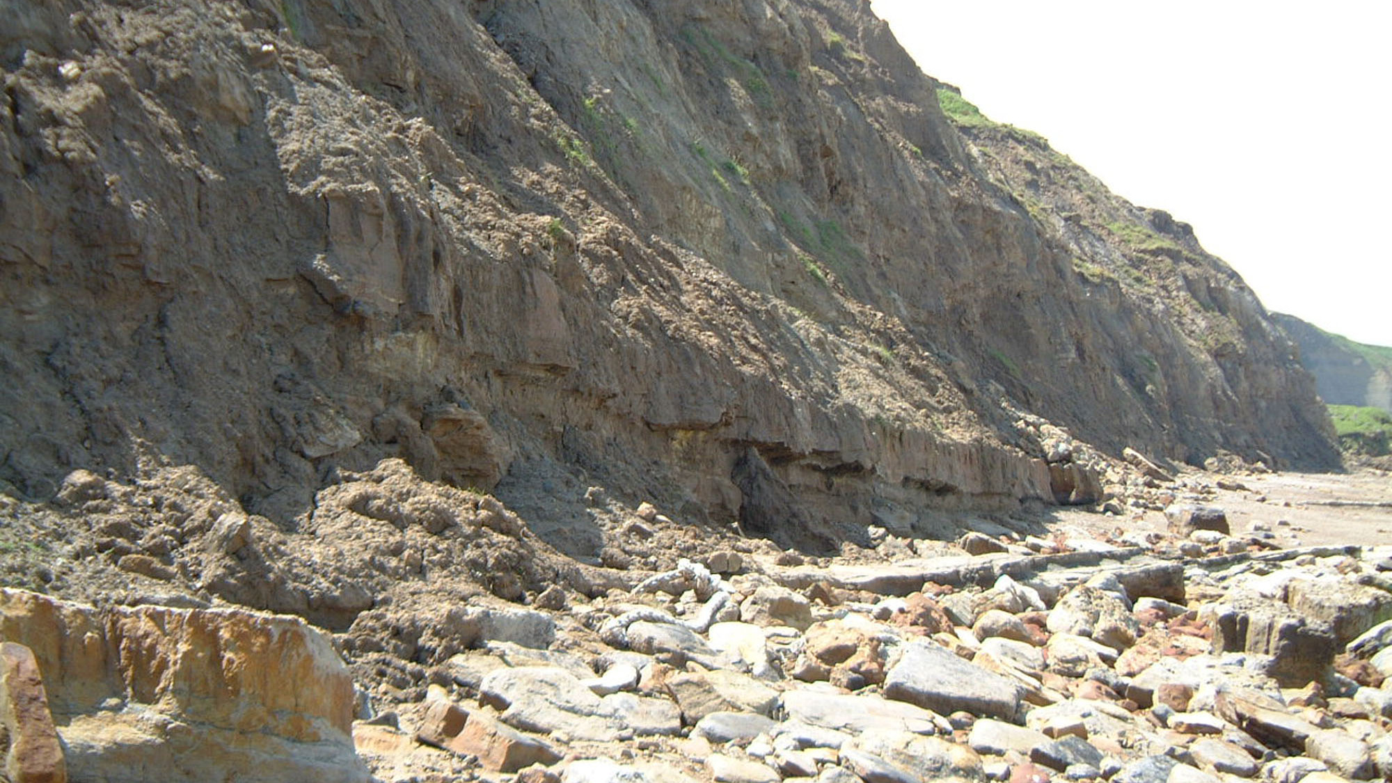
Overview
Directions
- Approach from the A165 towards Yons Nab, using the traditional narrow lane by the holiday park north of Lebberston. Do not obstruct farm or holiday-park access or assume lane-end parking is permitted.
- Follow the current signed public cliff-top path and descent only if open and sound. The lower access has a history of erosion damage; turn back if unsafe.
- The classic plant section is north of Yons Nab near Low Red Cliff. Walking south-east into the centre of Gristhorpe Bay reaches younger rocks instead. There is no through shore walk to Filey.
- Original broader locality reference: 54.23106°N, 0.32967°W. The published plant-section reference is TA 083 842; neither is a verified car-park pin.
Location photographs
Swipe to browse · Select a photograph to enlarge


Fossil Hunting
The classic Gristhorpe Plant Bed lies on the north side of Yons Nab near Red Cliff. Fine pale claystone can preserve dark, delicate leaves and reproductive organs, while darker silty pieces more commonly contain fragments. Examine already loose material where collection is permitted and photograph the bed relationships without attacking ledges.
Local records include Sagenopteris, Nilssonia, Caytonia, Elatides williamsonii, Cladophlebis denticulata and Todites. Leaves, seeds and reproductive structures need careful documentation; their association does not prove that all came from one reconstructed plant. Keep part and counterpart together.
Younger marine limestone, iron-rich sandstone and phosphatic nodules across the bay contain bivalves and ammonites. Published local records include Macrocephalites, Kepplerites and Quenstedtoceras, but their horizons differ. Label exact position, matrix and whether a find was loose rather than assigning every transported block to the same bed.
Dinosaur tracks and underprints can preserve distorted shapes transmitted through wet sediment, so shape alone does not uniquely identify a dinosaur species. Leave fixed tracks intact and record significant finds for specialist assessment.
Fossil photographs
Swipe to browse · Select a photograph to enlarge


Discoveries and milestones
A chronological record of discoveries, research and conservation at Gristhorpe.
1822–1828 – Early plant fossils illustrated
Young and Bird figured and described material from the Gristhorpe plant-bearing beds, among the earliest published accounts of this flora.
1829–1837 – The flora entered classic works
Phillips and then Lindley and Hutton illustrated Gristhorpe material. Lindley and Hutton recognised that plant cuticles were preserved, a feature later essential for identifying the fossils.
1860 – Plant-bed thickness recorded
Wright described the Gristhorpe Plant Bed as about two feet thick. This early observation helps distinguish the main fossiliferous claystone from broader plant-bearing intervals subsequently measured around it.
1864 – Leckenby’s plant study
Leckenby’s account added to the scientific documentation of the rich local flora and became part of the foundation for later revisions.
1915 – Williamsoniella described
Thomas described Williamsoniella, an important step in understanding the bennettitalean reproductive organs represented in the Gristhorpe flora.
1925 – The Caytonia plant reconstructed
Hamshaw Thomas linked seed-bearing Caytonia structures with associated pollen organs and Sagenopteris leaves from the Gristhorpe beds. His interpretation as an early flowering-plant relative was influential, although its reproductive anatomy was later reinterpreted.
1928 – Nested river channels described
Black documented the large basal Scalby channel east of Yons Nab and the smaller channel that cuts it. The contrasting pyrite-nodule and shale-clast basal deposits remain useful evidence of successive episodes of erosion and river deposition.
1941–1952 – Plant organs described and revised
T. M. Harris’s studies described or revised many Gristhorpe taxa, developing the anatomical framework later brought together in his Yorkshire Jurassic flora monographs.
1947–1948 – Conifers investigated
Kendall studied conifer remains from the Gristhorpe Bed, extending knowledge beyond the more conspicuous leaves and contributing to interpretation of the Jurassic vegetation.
1951–1958 – Caytonia anatomy reinterpreted
Harris showed that Caytonia enclosed seeds in an open cupule rather than a closed flowering-plant carpel. This revised a major interpretation of the locality’s most celebrated plant fossil.
1954 – The bay first notified for conservation
Gristhorpe Bay received its first formal notification, recognising the scientific importance of its strata and plant fossils.
1961–1979 – The Yorkshire Jurassic flora synthesised
Harris and collaborators incorporated extensive Gristhorpe material into a series of detailed monographs, including foliage, reproductive organs and whole-plant associations.
1981 – Sedimentary and microfossil evidence combined
Studies by Livera and Leeder, and Hancock and Fisher, examined the plant-bearing succession’s sedimentary environments and changes in its palynomorph assemblages. These helped relate plant preservation to channels, marine influence and shallowing conditions.
1986 – SSSI boundaries revised
The Gristhorpe Bay and Red Cliff citation records a revision that included some additional land and excluded other land from the earlier notified area.
1999 – Fossil wood and plant localities revisited
Morgans described pyritised conifer wood from wood-rich layers, while a specialist field guide revisited the Yorkshire Jurassic floras and the Gristhorpe section.
2003 – Dinosaur disturbance illustrated
Romano and Whyte illustrated underprinted tracks and disturbed bedding in a loose Long Nab Member block from Gristhorpe Bay, recording evidence of dinosaurs disturbing water-rich sediment.
2003 and 2009 – Mesofossils reveal reproductive detail
Material collected from the Gristhorpe Plant Bed at TA 083842 in 2003 underpinned Crane and Herendeen’s 2009 study. Scanning electron microscopy revealed detailed bennettitalean reproductive structures, complementing the classic larger fossils.
2015–2016 – Cycad pollen ultrastructure examined
Zavialova and van Konijnenburg-van Cittert studied Androstrobus manis pollen using documented Utrecht specimens from the Gristhorpe Plant Bed. The paper appeared online in 2015 and in the 2016 volume; these are publication dates, not newly assigned fossil-discovery dates.
Geology
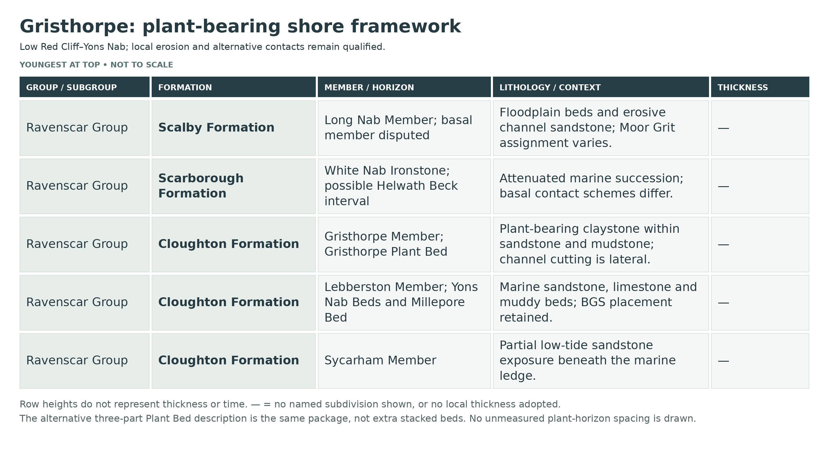
The older part of this coast records Middle Jurassic coastal plains, channels and episodes of marine flooding in the Ravenscar Group. Cloughton Formation plant-bearing strata around Yons Nab and Red Cliff are followed by the marine Scarborough Formation, of Bajocian age. The classic plant bed’s internal divisions and adjacent rooted and carbonaceous horizons are described individually below.
Names and boundaries need care. “Cayton Bay Formation” is an obsolete name associated with Lebberston strata and is not the separate Cayton Clay Formation higher in the succession. Current BGS treatment includes the Yons Nab Beds in the Lebberston Member, whereas the older GCR scheme placed them in the Gristhorpe Member. These interpretations are kept explicit rather than combined.
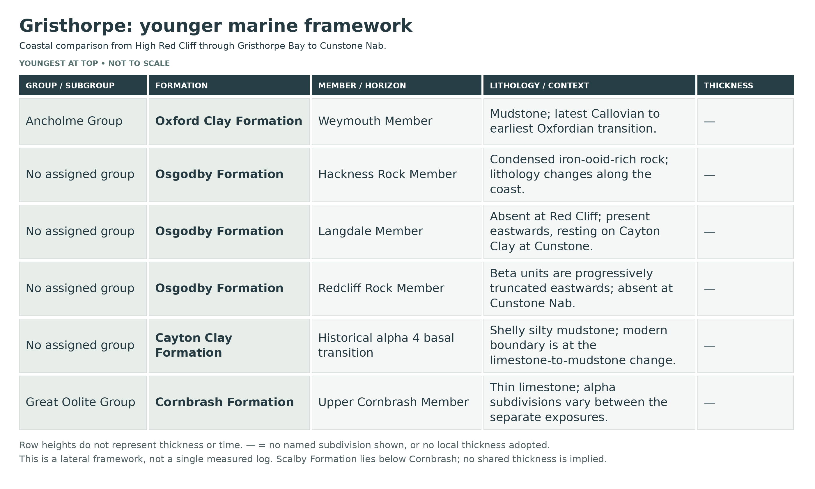
Younger rocks across the bay include the Scalby Formation, Callovian Upper Cornbrash, Cayton Clay and Osgodby Formation, with Oxford Clay also represented. The local Upper Cornbrash must not be assigned the full Bathonian–Callovian age range of the formation elsewhere. Marine shell beds contrast with the plant-bearing coastal-plain deposits.
This is a geographically composite coast. Measurements at High Red Cliff or Cunstone Nab do not all belong to the classic Low Red Cliff plant section, and some units thin or disappear laterally. The expanded succession preserves those limits, alternative plant-bed measurements and the possible rather than certain status of a highest beta subdivision.
Detailed geology and bed-by-bed succession
Detailed geology and fossil-bearing horizons at Gristhorpe.
Scope and lateral change
This account follows the plant-bearing shore at Low Red Cliff and Yons Nab into Gristhorpe Bay. Published composite sections also include High Red Cliff to the west and Cunstone Nab to the east; differences at those places are identified rather than combined into one supposedly continuous local log. The Red Cliff Fault juxtaposes different levels, while channels and later erosion remove beds over short distances.
RAVENSCAR GROUP
Cloughton Formation
The Bajocian succession alternates non-marine sandstone and plant-bearing mudstone with the marine Lebberston interval. “Cayton Bay Formation” in older accounts refers to the marine Lebberston unit, not the modern Cayton Clay Formation much higher in the succession.
Sycarham Member
At exceptionally low water, its sandstone can be seen beyond and below the Millepore ledge at Yons Nab. Channel sandstones cut older rooted deposits. Its exposure is partial, so a full regional member thickness would misrepresent the foreshore.
Plant horizon below the Millepore Bed
Harris’s recorded collecting horizons include a plant-bearing level about 5 m below the Millepore Bed. That historical position identifies a collecting horizon within the Sycarham Member; it is not an additional formal member or a guarantee that the layer is presently exposed.
Lebberston Member
The current BGS scheme includes both the Millepore Bed and Yons Nab Beds here. Some published sections place the Yons Nab Beds in the base of the Gristhorpe Member; those alternatives concern the boundary’s position, not two separate copies of the beds.
Millepore Bed — lower calcareous sandstone
Cross-bedded calcareous sandstone forms the lower part of the marine ledge. The GCR foreshore account describes about 7 m beneath its limestone cap, exposed only at very low tide. This exposure-based figure differs from the shorter stratotype interval quoted in the BGS Lexicon and should not be added to that separate measurement.
Millepore Bed — upper ooidal and bioclastic limestone
About 2 m of sandy ooidal limestone caps the foreshore ledge in the GCR account. Cross-bedding shows movement of sediment in shallow marine water. Fragments of the bryozoan historically called Millepora straminea, now commonly referred to as Haploecia straminea, explain the traditional name, although fragments are not abundant at every Yons Nab exposure.
Sideritic cap to the Millepore interval
The BGS type-section description records a sideritic nodule band marking the top of the informal Millepore Bed. It must be kept distinct from the younger ironstone-bearing layers within the Yons Nab Beds.
Yons Nab Beds — lower muddy interval
Shales with occasional ironstone bands and nodules overlie the Millepore ledge. A thin ripple-marked, burrowed sandstone interrupts the muddier lower beds. The transition records quieter conditions than the underlying mobile carbonate sand; fossils are concentrated unevenly rather than occurring throughout every shale layer.
Yons Nab Beds — upper flaggy interval and shell ledge
Alternating sandstone and shale pass upwards to a prominent ledge. Its iron-stained upper surface carries internal bivalve moulds, including Pholadomya, Trigonia and Pteroperna, with some shells in life position and large U-shaped burrows. The GCR gives approximately 5 m for the Yons Nab Beds, while the BGS stratotype account quotes 4 m; these are separately scoped descriptions.
Gristhorpe Member
Sandstones, siltstones and mudstones above the marine interval preserve roots, plant fragments and channel structures. The classic Gristhorpe Plant Bed lies low in this member. The non-marine beds are Bajocian and should not be assigned to the younger Scalby Formation merely because both contain plants.
Rooted and bioturbated basal sandstone
A resistant sandstone above the Yons Nab ledge contains iron-rich concretions and poorly preserved bivalves near its base, with substantial bioturbation higher up. The local field guide also records vertical roots. The published GCR account describes an approximately 4.5 m sandstone interval before the main plant bed; channel cutting makes simple layer-by-layer correlation unreliable around the point.
Channel sandstone beneath the plant bed
Near Yons Nab a north-east–south-west-trending channel cuts down into the Yons Nab Beds. Sandstone fill displays lateral-accretion and other channel structures. East of the point, ironstone-bearing sandstone with plant debris has yielded poorly preserved freshwater bivalves recorded as Unio. The fill is a lateral feature, not an extra bed to stack across the whole bay.
Gristhorpe Plant Bed — basal plant-debris claystone
The principal plant bed includes a lower claystone rich in plant fragments. It represents fine sediment accumulated as a channel was abandoned or in a lagoonal setting receiving nearby river-borne material. Interpretations vary in emphasis, but all require retention of the local sedimentary context rather than a generic swamp label.
Alternative three-part plant-bed description
The 2016 pollen study describes a plant bed up to 1 m thick between crevasse-splay sandstones: soft basal clay with the best-preserved specimens, an overlying clay-rich siltstone, then an iron-rich nodular interval with fewer plants. This is an alternative description of the same local package, not three extra beds to stack on the GCR’s differently worded subdivisions.
Gristhorpe Plant Bed — pale, soft claystone
The soft grey-white middle claystone preserves particularly fine dark leaves and reproductive structures. Delicate fossils include Sagenopteris, fern foliage and conifer shoots; Caytonia seed organs are central to the site’s scientific history. Preservation and floral composition change laterally within only a few metres. The classic bed is described as about 0.5 m in the palaeobotanical account; other accounts report around 0.6–1 m, and a larger 2.5 m estimate probably incorporates adjacent strata.
Gristhorpe Plant Bed — hard micaceous silty claystone
The upper part is firmer and more micaceous. U-shaped Diplocraterion burrows indicate renewed marine influence. Medium and darker grey silty rock generally carries more fragmented plant material than the pale claystone, so not all plant-bearing stones have equivalent preservation.
Black layers adjoining the Gristhorpe Bed
Historical collecting records distinguish a black layer below and another above the Gristhorpe Bed. They are named collecting horizons rather than a measured pair of formal beds, and must not be silently equated with the three lithological subdivisions of the main plant bed.
Bioturbated carbonaceous sandstone lens
A plant-rich, strongly burrowed sandstone lens occurs above the main plant-bearing interval. Its lens geometry and lateral variability are significant; the field guide illustrates this feature separately from the plant bed itself.
Rooted sandstone and upper sheet sandstones
Higher beds include sandstone with vertical horsetail roots and rooted sheet sandstones. Loaded bases and contorted lamination show deformation of wet sediment, while rooting records later colonisation. These upper horizons should not be used to claim that horsetail foliage is common in the classic Gristhorpe Plant Bed, whose flora is separately described.
Scarborough Formation
Marine conditions returned in the Bajocian. The formation is strongly attenuated around Yons Nab, unlike its thicker sections farther north; its complete seven-member northern succession is not exposed here.
Helwath Beck Member
In the GCR interpretation, about 1.3 m of finely laminated siltstone with ripple-drift and scour-and-fill structures lies at the base. A later field guide treats a roughly 1.4 m cross-bedded sandstone beneath its narrower Scarborough interval as upper Gristhorpe strata, while noting the alternative Helwath Beck assignment. These are alternative contact schemes and should not be duplicated as separate stacked units.
White Nab Ironstone Member
The GCR assigns the overlying approximately 2 m of soft muddy shelly limestone or shale to this member. Crushed Lopha, Meleagrinella and Trigonia occur with gastropods and belemnites; an ironstone-concretion layer lies near the top. The 2006 field guide describes a 2.8 m limy-shale section with two upper ironstone bands at Low Red Cliff. These are local section descriptions, not grounds for importing thicker northern members.
Scalby Formation
The Bathonian non-marine succession cuts into the Scarborough Formation. At Low Red Cliff, lenticular pale sandstone and grey siltstone contain coalified plant material; weathering of pyritised debris can produce conspicuous yellow coatings. The formation thickens into Gristhorpe Bay to nearly 40 m in the published composite account.
Moor Grit Member
The basal channel sandstone at Yons Nab has been recognised as Moor Grit by some workers, whereas another sedimentological account regarded that member as absent. Preserve the documented uncertainty rather than forcing a regionally uniform basal unit.
Large basal channel and later nested channel
The channel east of Yons Nab erodes the top of the Scarborough Formation. A pyrite-nodule conglomerate marks its base; a smaller later channel cuts the fill and begins with a shale-clast conglomerate. These distinct erosional surfaces were described by Black in 1928 and are important field observations.
Long Nab Member
The upper Scalby succession comprises finer floodplain deposits and sandstone bodies. Plant-rich mudstone and siltstone contrast with coarser channel sand. A published loose block from Gristhorpe Bay preserves underprinted dinosaur tracks and disturbed bedding assigned to this member; its exact original bed cannot be reconstructed from the loose specimen alone.
Other historically named Scalby plant horizons
Harris’s locality register separately identifies Black’s Upper Estuarine Plant Bed, a grey-limestone occurrence, a bed above a channel, Hill’s named plant bed, Kendall’s cliff-foot bed and Mell–Casty Hill occurrences numbered 1, 3 and 4. These are historical collecting records across the Gristhorpe tract, not a continuous measured log or present-day access instructions. Their recorded names should be retained with locality provenance without inventing thicknesses or correlations.
GREAT OOLITE GROUP
Cornbrash Formation
The thin marine limestone above the Scalby Formation marks the return of sustained marine deposition. The local unit belongs to the Callovian Upper Cornbrash, not the Bathonian Lower Cornbrash of southern England. The lettered subdivisions below are Wright’s local units, not formal members.
Upper Cornbrash Member (formerly Fleet Member)
Unit α1 — basal iron-rich limestone
A burrowed boundary rests on Scalby mudstone. The coastal composite range is 0.14–0.37 m for greenish-grey, reddish-weathering berthierine/sideritic limestone, becoming muddier towards Cunstone Nab. Bivalves dominate, including Entolium, oysters and burrowing forms; rare Macrocephalites provides age evidence. This range is for the described coast, not one universal Gristhorpe measurement.
Unit α2 — pale shelly limestone
About 0.15 m of pale-grey shell limestone is variably ooidal and locally micritic. Bivalves again dominate, but gastropods and Macrocephalites also occur. The named subdivision is part of the coastal comparative scheme; its presence must not be assumed at every separate exposure.
Unit α3 — erosive sandy limestone
This hard sandy limestone is developed in Gristhorpe Bay, where it reaches about 0.18 m, but is absent below Red Cliff. Its erosional base and bivalve-rich fabric record a separate phase of deposition; rare Macrocephalites kamptus was reported. The lateral absence matters as much as the thickness.
Unit α4 — shale transition
A thin silty or sandy shale grades towards the overlying Cayton Clay. It contains Entolium and Meleagrinella; a local Gristhorpe record includes the brachiopod Microthyridina. No single thickness is imposed on this variable transition. This is alpha 4 of the historical Cornbrash scheme. The modern BGS boundary at the change from limestone to shelly mudstone places this transitional shale with basal Cayton Clay; the historical numbering does not establish an unchanged modern formation assignment.
Cayton Clay Formation
Grey clay and silty mudstone contain phosphatic nodules with small bivalves, crustacean fragments and occasional Macrocephalites ammonites. Upward increase in sand leads into the Redcliff Rock Member. The BGS assigns this formation no parent group; it is not a subdivision of the Great Oolite or Oxford Clay.
Phosphatic nodule bands
Diffuse concentrations of small pale-grey nodules can preserve fossils with less crushing than the surrounding mudstone. Their horizon and locality should be recorded; an ammonite and a crustacean in the same formation are not the same fossil group. No named formal bed is assigned to each nodule band.
Osgodby Formation
Callovian sandstone, sandy limestone and iron-rich ooidal layers change markedly between Red Cliff, Gristhorpe Bay and Cunstone Nab. Erosion progressively cuts out parts of the lower succession eastwards. The formation has no assigned parent group in the BGS Lexicon.
Redcliff Rock Member
The well-developed type section is at Red Cliff, west of the plant-bearing point. Its numbered subdivisions can be compared into Gristhorpe Bay, but β2–β5 are successively truncated towards Cunstone Nab, where the member disappears. Composite maxima must not be drawn as a measured Gristhorpe stack.
Unit β1 — lower pale sandstone
Pale yellowish sandstone grades up from Cayton Clay and contains hard calcareous concretions. Most rock is sparsely fossiliferous, but some nodules contain small bivalves; Kepplerites is recorded near the top. The GCR coastal description gives a maximum 6.85 m, not an exposure-wide constant.
Unit β2 — iron-ooid sandstone
Rusty orange–brown sandstone contains berthierine ooids and a richer fauna than β1. Entolium, oysters and Modiolus occur with Kepplerites, Proplanulites and other ammonites. Its published maximum is 2.35 m in the comparative coastal succession.
Unit β3 — less ooidal fossiliferous sandstone
The next sandstone has few or no ooids, and a varied bivalve and ammonite assemblage with occasional belemnites. The coastal maximum quoted is 1.98 m; the bed is among those removed eastwards beneath the Langdale erosion surface.
Units β4 and β5 — impersistent upper Redcliff beds
At Red Cliff, β4 is an intermittently developed, pale-weathering ooidal sandstone up to 0.55 m, with shelly concretions and rare ammonites. A possible β5 soft sandstone, up to 0.65 m, is less securely recognised. These Red Cliff records are comparative markers, not confirmed complete beds everywhere in Gristhorpe Bay.
Langdale Member
The sandstone and siltstone above the Redcliff beds rests on an erosional surface. It is absent at Red Cliff and becomes developed eastwards; at Cunstone Nab a 2.35 m fine–medium sandstone with ripple lamination and clay wisps rests on thinned Cayton Clay after the entire Redcliff Rock Member has been removed. That eastern measurement is retained as lateral context.
Cunstone Nab ammonite level within γ1
At Cunstone Nab, about 0.65 m above the Langdale base, poorly preserved Erymnoceras and Kosmoceras give Middle Callovian age evidence. This is an eastern reference horizon, not a find guarantee for the Gristhorpe plant-bed foreshore.
Hackness Rock Member
Hard greenish-grey, iron-ooid-rich rock is developed at Red Cliff. Eastwards in Gristhorpe Bay a tough ooidal limestone yields Quenstedtoceras; bivalves accompany comparatively uncommon age-diagnostic ammonites. The overlying contact varies locally and should not be represented as one universally complete boundary section.
Cunstone Nab Bed 4 — terminal Hackness interval
At the eastern comparison section, 0.15 m of slightly ooidal calcareous sandy siltstone carries a diverse ammonite assemblage including Quenstedtoceras, Peltoceras and Kosmoceras. This Bed 4 belongs to Wright’s Cunstone log, not the Filey or Tenants’ Cliff numbering systems.
ANCHOLME GROUP
Oxford Clay Formation
The mudstone above the Hackness Rock extends high into the cliffs in Gristhorpe Bay. Its finer sediment records a major change from the earlier sand- and ooid-rich marine deposits. Dark or weathered clay alone is not enough to identify a loose specimen’s formation.
Weymouth Member
Only the upper Oxford Clay succession is present in the Cleveland Basin. The boundary interval includes latest Callovian and earliest Oxfordian faunas; a lithostratigraphic formation boundary should not be assumed to coincide exactly with the stage boundary.
Cunstone Nab Bed 5 and succeeding basal Oxfordian horizon
At Cunstone Nab, 0.15 m of sandy grey clay with scattered ooids carries abundant Quenstedtoceras paucicostatum and is best assigned to basal Oxford Clay. Another 0.15 m of silty clay with ooidal nodules yields Cardioceras of the scarburgense group. The first fauna is terminal Callovian; the latter marks the basal Oxfordian. These thin eastern beds must not be transferred without evidence to every Gristhorpe exposure.
Superficial deposits, fallen blocks and access
Glacial deposits and landslips conceal parts of the cliff, while sand and shingle cover the foreshore intermittently. Fallen blocks may expose fossils clearly but lose their exact position in the sequence. None of the geological descriptions implies permission to excavate fixed beds or enter unstable cliff areas.
Plant organs and modern microscopic studies
Mesofossils collected in 2003 at TA 083842 were studied by Crane and Herendeen in 2009, revealing fine bennettitalean reproductive structures. Later work examined pollen from Androstrobus manis specimens 1370, 8509 and 7560 at Utrecht. Associations link Nilssonia compta, A. manis, Beania gracilis and Deltolepis crepidota, but their stem is unknown; Harris’s 1961 whole-plant reconstruction concerned a related plant, not this complete local organism.
References
UK Fossils: Gristhorpe (existing guide; inspected 2006)
Cox & Sumbler (2002): Gristhorpe Bay, Yons Nab and Red Cliff–Cunstone Nab, GCR 26
Cleal and colleagues (2001): Red Cliff (Gristhorpe Bay/Cayton Bay), GCR 22
Whyte & Romano (2006): Middle–Upper Jurassic sequence between Cayton Bay and Yons Nab
BGS Lexicon: Lebberston Member
BGS Lexicon: Gristhorpe Member
BGS Lexicon: Scarborough Formation
BGS Lexicon: Scalby Formation
BGS Lexicon: Cornbrash Formation and Upper Cornbrash Member
BGS Lexicon: Cayton Clay Formation
BGS Lexicon: Osgodby Formation
BGS Lexicon: Oxford Clay Formation
Romano & Whyte (2003): Jurassic dinosaur tracks and trackways of the Cleveland Basin
BGS Lexicon: Cornbrash Formation
BGS Lexicon: Cloughton Formation
Crane & Herendeen (2009), Bennettitales from the Grisethorpe Bed
Zavialova & van Konijnenburg-van Cittert (online 2015; volume 2016), Androstrobus manis pollen study
Safety
The shore east of Yons Nab is cut off at high water, and gullies behind the Millepore ledge fill on a rising tide. Check tide, weather and swell; plan a falling-tide visit with a generous return margin. Never attempt a through walk to Filey.
Keep away from cliff toes, overhangs, fresh falls and soft till slips. Algae-covered ledges and boulders are slippery. A helmet is no protection against the risks of standing beneath an unstable cliff.
Equipment
Take grippy boots, a hand lens, camera or notebook, padded rigid boxes and supports for fragile slabs. Photograph fixed exposures and avoid tools or methods that damage beds or tracks.
Cleaning And Treating
Do not wash soft plant-bearing claystone or brush across carbon films; leaves and cuticle can detach. Support the slab, retain its counterpart and fragments, and dry slowly in stable conditions.
Keep pyritised wood and nodules dry and monitored. Avoid routine coatings, soaking and aggressive trimming. Do not acid-treat marine calcareous fossils or force them from hard cement; seek specialist help for unusual or unstable specimens.
Identify Your Finds
Need help identifying a fossil? Share clear photos, where you found it and its size with the community.
Further Reading
Deposits: Bryozoans in the British Jurassic
Cox & Sumbler (2002): Gristhorpe Bay, Yons Nab and Red Cliff–Cunstone Nab, GCR 26
Cleal and colleagues (2001): Red Cliff (Gristhorpe Bay/Cayton Bay), GCR 22
Whyte & Romano (2006): Middle–Upper Jurassic sequence between Cayton Bay and Yons Nab
BGS Lexicon: Lebberston Member
BGS Lexicon: Gristhorpe Member
Natural England: Gristhorpe Bay and Red Cliff SSSI citation
Romano & Whyte (2003): Jurassic dinosaur tracks and trackways of the Cleveland Basin
Crane & Herendeen (2009), Bennettitales from the Grisethorpe Bed
Zavialova & van Konijnenburg-van Cittert (online 2015; volume 2016), Androstrobus manis pollen study
Access Rights
Gristhorpe Bay and Red Cliff SSSI protects the geological and palaeobotanical interest; the original linked citation gives further information. Follow current landowner and management requirements, keep fixed beds and tracks intact and observe temporary closures. Proposed designation changes do not establish a completed new protected-site boundary or unrestricted collecting permission.
It is important to follow our ‘Code of Conduct’ when collecting fossils or visiting any site. Please also read our ‘Terms and Conditions’.
Links
♦ Fossil Discussions
♦ Fossil Articles
♦ Buy Fossils, Tools and Equipment
♦ Buy Crystals, Meteorites, and Artefacts
♦ Join Fossil Hunts
♦ UK Fossils Network


