
Overview
Directions
- Approach Holymoorside via the minor road through Slatepit Dale from the A632 near Chesterfield. The United Reformed Church is the landmark used in the original route description.
- The old guide records a bus stop and small lay-by just beyond the church. Check current signs before parking, keep the bus stop and access clear, and use another lawful space if stopping is restricted or the lay-by is unsuitable.
- Return towards the church and follow the signed public footpath on its far side. Where the route reaches two stiles, the original description takes the left-hand one. Follow the current waymarks and a current public-path map if the furniture or field layout has changed.
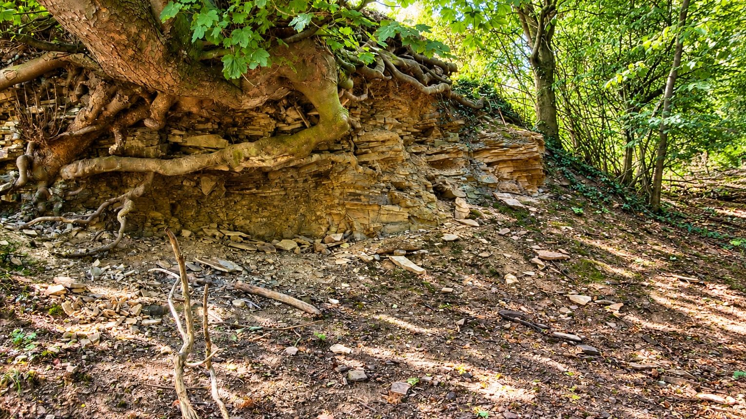
- Continue past the hill on the left. The small quarry lies among trees on the right, part-way up the slope. Remain on the public path unless the landowner has agreed to entry; do not climb the face or pull loose slabs from beneath the trees.
- Original UK Fossils quarry reference: SK 33960 69039. This locates the quarry rather than an approved entrance, parking space or collecting area.
Location photographs
Swipe to browse · Select a photograph to enlarge


Fossil Hunting
Holymoorside is a modest plant-fossil locality rather than a place to expect large, complete Carboniferous plants. The 2011 field account records stem fragments and scattered plant debris in the upper exposed flags, with recognisable small leaves much less common. It also notes that formerly more productive lower levels were already hidden by scree. Those are dated observations, not a report of the present condition of the face.
The fossils occur on or within fine sandstone and associated finer-grained layers. On a naturally exposed bedding surface, a plant fragment may appear as a dark carbonaceous mark or a shallow impression with a shape that contrasts with the mineral grains around it. Stem material is often broken and flattened, so length alone is not a useful identification. Look for repeated ribs, a consistent outline or a genuine surface pattern, and photograph the whole fragment before examining smaller details.
Small leaf fragments are harder to recognise because torn edges and incomplete preservation can obscure their original shape. A hand lens and a photograph taken with light across the surface may reveal detail that is difficult to see in the quarry’s shade. Mineral staining, mica-rich partings and natural fractures can imitate plant outlines. No securely documented genus or species has been established for the specimens illustrated in this guide, so an identification should remain at plant stem or leaf fragment unless diagnostic features are clear.
Thin partings help explain why the rock was worked as flags and why fossils can be revealed on bedding surfaces. They also make slabs liable to loosen. The older instruction to pull large sections from the face is unsafe and should not be followed. Do not dig through scree to uncover lower beds, work below overhangs or remove supporting blocks. If the landowner permits examination of loose material, use only stable pieces that can be inspected without disturbing the slope or approaching the face.
For any authorised specimen, record whether it came from loose debris or a securely identified bed. Scree mixes fragments from different levels and cannot reproduce the quarry’s original succession. Keep both matching halves of a naturally separated fossil-bearing slab when their removal is expressly permitted, and photograph them before wrapping. A small, well-recorded example is more useful than a bag of unlabelled fragments.


Discoveries and milestones
Significant discoveries, geological research and conservation milestones at Holymoorside.
1967 – The sandstone belt is described by the Geological Survey
The district memoir mapped and described the Wingfield Flags through Holymoorside. It placed the local sandstone within a wider set of exposures and correlations, rather than supplying a measured log of this small quarry.
2003 – A Holymoorside geological itinerary is published
John Marriott’s itinerary in Geologists’ Association Guide 63 introduced the Upper Carboniferous sequence and industrial landscape around Holymoorside. It is a regional field guide; its publication does not establish that this particular quarry was newly discovered or measured.
Geology
The Wingfield Flags form part of the Pennine Lower Coal Measures Formation within the Pennine Coal Measures Group. They belong to the early part of the traditional Westphalian succession, commonly described here as Langsettian. Wingfield Flags is a sandstone-unit name, not a separate formation. This distinction places the quarry within the wider Coal Measures without inventing an additional stratigraphic rank.
Fine sandstone alternates with finer siltstone and shale in the mapped unit. Sand and mud accumulated in the low-lying Carboniferous sedimentary landscape, where water transported both mineral grains and fragments of vegetation. The plant material in the flags need not have grown at precisely the place where it was buried. Broken stems and uncommon small leaves are consistent with transported debris, rather than proof of an intact forest floor exposed in this quarry.
Changes in grain size and the abundance of fine partings influence how the rock weathers and splits. More resistant sandstone can form small scarps, while softer interbeds wear back into hollows. Across the Holymoorside–Harper Hill belt the Survey describes several such features and gives a regional thickness of 100–200 ft, approximately 30–61 m. That regional figure does not measure the small face beside the footpath.
The old quarry exposed only part of this succession. Its 2011 description records surviving upper beds and scree covering lower plant-bearing flags, but gives neither a measured bed log nor a complete quarry thickness. Nearby Linacre, Freebirch and Bole Hill sections describe different exposures. Their individual beds, fossil bands and measurements cannot be fitted into the gaps in the Holymoorside face.
Quarrying and later weathering have further changed what can be seen. Loose slabs beneath trees may illustrate the sandstone’s texture and plant preservation, but their position no longer establishes their original height in the sequence. Geological observation here is therefore most useful when it distinguishes intact bedding, fallen material and the broader mapped sandstone belt.

Detailed geology and bed-by-bed succession
Detailed geology of the Holymoorside quarry and its regional sandstone context.
This section concerns the small wooded quarry reached from the Holymoorside village footpath. The regional sandstone belt is well documented, but no measured bed-by-bed section of this particular quarry has been recovered. The quarry observations below come from the original 2011 visit and do not establish its current exposure or condition.
PENNINE COAL MEASURES GROUP
Pennine Lower Coal Measures Formation
Wingfield Flags. Fine sandstone with finer-grained siltstone and shale partings forms the named unit mapped through Holymoorside. The traditional local age is Langsettian, in the lower part of the Westphalian succession. Wingfield Flags is a named sandstone unit within the formation, rather than an additional formation. Neither a formal local member subdivision nor a complete measured thickness is established for the guide quarry.
Surviving upper quarry beds. The 2011 field account describes only the upper part of the former quarry sequence as exposed. Plant stems and scattered debris were relatively frequent in those flags, while better-preserved small leaves were uncommon. The record supplies no bed numbers, individual thicknesses or diagnostic plant names. It therefore supports a general plant-debris assemblage rather than a list of named Carboniferous plant genera.
Covered lower flags and scree. The same account records that lower beds, formerly more productive for recognisable plant remains, were hidden by scree. That is a dated observation of quarry condition, not evidence for a precisely located fossil bed that can now be uncovered. Fallen slabs can mix material from several levels. Do not excavate scree or destabilise the face to look for the lower beds.
The wider Holymoorside–Harper Hill belt. The Survey traces the Wingfield Flags through Holymoorside, Moorlawn Coppice and Slatepitdale towards Harper Hill. Fine sandstones with interbanded shale and siltstone produce several scarps with intervening hollows. Its reported 100–200 ft, approximately 30–61 m, thickness describes this regional belt, not the exposed height of the small quarry. Farther north the Wingfield Flags collectively correlate with sandstone intervals called Brincliffe Edge or Greenmoor Rock and Grenoside Sandstone. Those correlations do not identify two separate sandstone members or their contact in this quarry.
Limits of comparison. Measured logs at Freebirch, the Linacre reservoirs and Bole Hill belong to different exposures. They show how the sandstone belt changes across the district, but their individual flag thicknesses, shale beds, fossil bands and petrographic samples do not provide missing measurements for this quarry. The local succession should remain unmeasured until evidence from the actual face establishes otherwise.
References.
BGS Lexicon: Wingfield Flags.
BGS Lexicon: Pennine Lower Coal Measures Formation.
Smith, Rhys and Eden (1967): Geology of the country around Chesterfield, Matlock and Mansfield.
UK Fossils: original Holymoorside field observations, inspected 2011.
Safety
The old field account explicitly warns that the face is unstable and can fall. Keep well away from the face, overhangs and tree-rooted slabs, and do not stand beneath someone examining higher ground. A small or disused quarry can still contain serious rockfall hazards.
Do not pull out sandstone flags, dig into scree, climb the face or work at the top edge. Leaves and vegetation may conceal loose stone and holes, while wet sandstone and muddy ground can be slippery. Leave the quarry if a safe observation position is unavailable.
Keep children on the public path and under close supervision. Wear sturdy footwear, take suitable clothing for the weather and avoid the wooded slope during strong winds. Follow current signs and respect any fence or barrier.
Equipment
For a path-side visit, take sturdy walking boots, a map, a camera and a hand lens. A small scale is useful for photographing plant impressions. A torch can help with viewing safely accessible loose rock in shade, but should not encourage entry beneath an unstable face.
Do not take a pick or hammer with the intention of extracting flags. Collecting requires landowner permission and a safe method agreed for the material concerned. For any specifically authorised loose specimen, use paper wrapping and a rigid container to protect thin slabs.
Cleaning And Treating
Plant films and impressions can be damaged by enthusiastic cleaning. Begin with a soft dry brush on a lawfully obtained specimen, supporting the slab on a flat surface. Avoid brushing directly across fragile carbonaceous material.
Let a damp specimen dry slowly at room temperature. Do not soak an untested slab, as fine partings may separate or the rock may soften. Avoid acids, bleach, varnish and forceful attempts to split or peel the fossil-bearing surface. Seek specialist advice before treating a friable or potentially important plant fossil, and retain the locality and provenance label.
Identify Your Finds
Need help identifying a fossil? Share clear photos, where you found it and its size with the community.
Further Reading
BGS Lexicon: Wingfield Flags
BGS Lexicon: Pennine Lower Coal Measures Formation
British Geological Survey: Chesterfield, Matlock and Mansfield district
Geologists’ Association field-guide catalogue: Holymoorside regional itinerary in Guide 63
Access Rights
Use the public footpath and follow current waymarks. The right to pass along a path does not include unrestricted access to the quarry, permission to dig or a right to remove fossils and stone. Obtain the landowner’s agreement before entering or collecting.
No current collecting permission has been established for this guide. The older statement that the locality had no restrictions should not be relied upon. Leave fences, trees, quarry faces and loose supporting blocks undisturbed, and respect any closure or refusal of access.
It is important to follow our ‘Code of Conduct’ when collecting fossils or visiting any site. Please also read our ‘Terms and Conditions‘
Links
♦ Fossil Discussions
♦ Fossil Articles
♦ Buy Fossils, Tools and Equipment
♦ Buy Crystals, Meteorites, and Artefacts
♦ Join Fossil Hunts
♦ UK Fossils Network


