

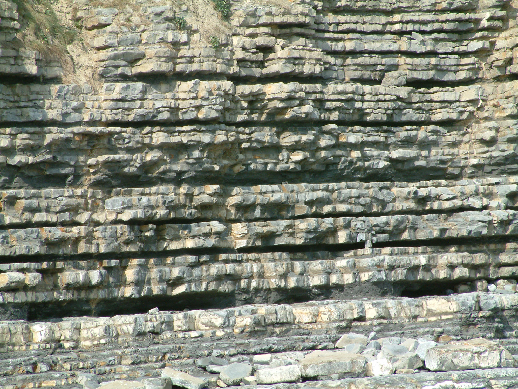
At Llantwit Major’s Cwm Colhuw beach, pale limestone ledges and darker mudstones reveal a fossil-rich Early Jurassic sea. Ammonites and bivalves are the main attractions, often preserved as impressions or shells within the foreshore rocks. The striking cliffs and jointed platforms also make this a rewarding place to see how sedimentary rocks weather and break apart.


FIND FREQUENCY: ♦♦♦ – Ammonites and bivalves are the most likely recognisable fossils, often still enclosed in rock. Previous collecting has affected the beach; do not expect every visit to produce a removable specimen.
CHILDREN: ♦♦♦♦ – A family visit can be rewarding with close supervision, especially around slippery platforms, deep pools and the sea. Stay well away from the high cliffs and fresh falls.
ACCESS: ♦♦♦♦♦ – The beach car park gives a short approach, with a café and toilets listed at the main beach. The shore itself is rocky and uneven; a short route does not mean step-free access throughout.
TYPE: – Coastal foreshore and high limestone–mudstone cliffs. Concentrate on observation and photography from safe open areas; do not hammer bedrock, work sea defences or enter the cliff-fall zone.
DIRECTIONS
♦ From Llantwit Major, follow signs through the town towards the beach at Cwm Colhuw, also written Cwm Col Hugh. The road follows the valley to the beach car park.
♦ Use the normal beach approach near the café and toilets, checking current parking and facility notices on arrival. Bay reference: 51.39647°N, 3.50198°W.
♦ This guide follows the original locality eastwards from the main beach. Search only as far as tide, swell and the open return route allow; do not turn the visit into a traverse to Stout Point or Summerhouse Point without separately planning that route.
♦ Check the tide and weather forecast before travelling and allow ample return time on a falling-tide visit. Do not rely on an escape through adjacent fields or over eroding cliff paths.
FOSSIL HUNTING
Start with a small, accessible area of the open foreshore instead of trying to cover the whole beach. Look at naturally weathered surfaces of limestone and the muddier material between ledges. Ammonite impressions may show a recognisable coil, ribs or part of a whorl without preserving a complete shell. Amgueddfa Cymru’s account of this exact beach illustrates ammonites in loose boulders and recommends leaving them rather than hammering the rock.
Bivalves are another useful starting point. Look for curved shell outlines, paired valves and shell sections exposed by erosion. Historic museum collections include oysters collected at Llantwit Major, although the surviving published collection account does not tie every specimen to a particular beach bed. Gryphaea is an oyster, hence a bivalve; identifying a weathered shell to species requires more than its size or a resemblance to a familiar ‘devil’s toenail’.
The limestone and mudstone alternation matters. Hard limestone commonly holds fossils firmly in the matrix, while softer layers weather differently and may expose less complete remains. A fossil seen on a surface is not necessarily easy to extract intact. Photograph the specimen with a scale and include a wider view of the rock so that its setting remains clear. Do not prise fossils from the platforms or dismantle embedded blocks.
Fish remains and ichthyosaur bones are occasional possibilities recognised by the museum’s local account. An isolated fragment cannot automatically be called Ichthyosaurus: that is a particular genus, whereas ‘ichthyosaur’ covers a broader group of marine reptiles. Suspected bone should be photographed and its position recorded before seeking museum advice. Do not follow the old guide’s suggestion of chiselling bones out of the shale.
The earlier guide described unusually large gastropods and oysters and a wide variety of other fossils. Size alone is not a reliable identification, and stronger exact-beach evidence does not establish that corals, sponges, echinoids or brachiopods are common here. The retained original photographs remain useful records to examine, but a caption or an old broad comparison with Watchet is not a substitute for a verified specimen identification.
Keep the geographical context of a find. The ammonite-rich reef described historically near Summerhouse Point is farther east, and fossils from an old quarry near Llantwit church are inland records. Neither is a fossil bed at the main Cwm Colhuw beach. Carboniferous Limestone was also imported for coastal defences: any fossil within a defence block belongs to the source rock of that block, not proof of Carboniferous bedrock beneath this Jurassic beach. Leave the sea defences untouched.


Significant discoveries, geological research and conservation milestones at Llantwit Major.
1922 – The local cliff system is placed in an ammonite framework
A.E. Trueman documented the succession and its historical ammonite correlation, distinguishing Cwm Col Hugh from the exposures at Stout Point and Summerhouse Point. His account remains important for keeping the coast’s individual fossil horizons in their correct localities.
1969 – A cliff-stabilisation attempt changes the rock face
Blasting was used in an attempt to stabilise the Colhuw cliffs. Later research recorded that the approach failed: protective fallen material was removed and fracturing increased, illustrating the complexity of managing an actively eroding limestone coast.
1993–1996 – Imported stone is used in coastal protection
A revetment was built using Carboniferous Limestone blocks. This introduced a different geological material to the beach, important when distinguishing fossils in engineered sea defences from those in the natural Jurassic succession.
1996 – Colhuw cliff failures are studied in detail
Williams, Davies and Belov investigated rock strength, waves, undercutting and block movement at the beach. Their study identified the importance of a shale weakness at horizon 28 and resistant limestone bands in the geometry of local failures.
1998 – Historic Llantwit oyster collections are documented
Michael G. Bassett traced the survival of Swansea research collections that included oysters collected at Llantwit by Trueman and Trevor Marchant. The documented drawers and catalogues covered several coastal localities, preserving useful provenance without establishing a Llantwit-only specimen total.
2001 – A limestone pavement helps test fracture-mapping methods
Mauldon, Dunne and Rohrbaugh used a measured Llantwit shore surface to assess methods for sampling fracture traces. Its master joints and younger cross joints provided a clear example of how sampling choices can affect the interpretation of a rock’s fracture network.
GEOLOGY
The local cliffs and shore platforms belong to the Lias Group, principally the Blue Lias Formation and Porthkerry Member. The correct spelling is Porthkerry; the older term ‘Porthkerry Formation’ reflects a former stratigraphic rank. The cliff system includes latest Hettangian, Angulata Zone mud-rich beds and lower Sinemurian, Bucklandi Zone limestone-rich beds. These ammonite zones describe intervals used for dating and correlation, not extra rock formations stacked between the named units.
The pale resistant limestones and darker, more easily weathered mudstones produce the stepped appearance of the cliffs. Their contrast began with differences in sediment and was modified by processes during burial. Where mudstone retreats, limestone can project as a ledge; joints divide that ledge into blocks. Groundwater, weathering, waves and undercutting act together, so a face that appears solid can still release large joint-bounded blocks.
At Colhuw the limestone-rich Bucklandi interval dominates the cliffs. An anticlinal flexure locally brings about 6 m of the underlying Angulata interval into the lower cliff, exposing mainly mudstone with thin limestone beds. The 1996 cliff study also described a shale weakness at its numbered horizon 28 and resistant limestone bands at horizons 39 and 49. These are local engineering observations within an older numbering scheme, not a complete bed-by-bed fossil log.
Faulting and folding change the height at which the beds meet the shore. A large fault brings beds numbered 39–49 down to platform level in the published Colhuw account. Farther east, Stout Point has conspicuous monoclines and faulting, but its structural sections cannot simply be substituted for a measured log at Cwm Colhuw. The same caution applies westwards to the much better-known Nash Point marker beds.
The shore’s joint patterns have scientific value in their own right. A mapped Llantwit limestone pavement was used to test methods of measuring fracture traces: an older set of master joints and younger cross joints form a ladder-like pattern. Observing that geometry from a safe position helps explain both the rectangular shapes of some loose blocks and why preserving an undamaged rock surface matters.

Detailed geology and stratigraphy at Llantwit Major / Cwm Colhuw.
Locality and evidence. The guide starts at Cwm Colhuw, also written Cwm Col Hugh, and covers the adjacent eastern foreshore. St Donat’s and Nash Point lie to the west; Stout Point and Summerhouse Point are separate exposures farther east. Published regional diagrams and the latter localities’ fossil horizons are not a single measured Cwm Colhuw log.
LIAS GROUP
Blue Lias Formation
Porthkerry Member
Formal terminology and age. Current BGS usage places the Porthkerry Member in the Blue Lias Formation. ‘Porthkerry Formation’ is an older rank for the rock unit, while ‘Portkerry’ in the earlier guide was a misspelling. The local cliff system includes latest Hettangian Angulata Zone and lower Sinemurian Bucklandi Zone strata. Ammonite zones and subzones are correlation intervals, not additional lithostratigraphic formations or members.
Angulata interval — about 6 m locally exposed. Mainly mudstone with thin limestones appears in the lower cliffs where an anticlinal flexure raises the beds. The 1996 Colhuw study’s approximately 6 m is the thickness exposed at that local structure, not the full thickness of the ammonite zone, member or formation. The younger limestone-rich interval above contrasts clearly with these muddier beds. Low-angle fractures in these Angulata beds were attributed to horizontal tectonic shear.
Bucklandi interval — the dominant cliff succession. Alternating, mainly limestone beds with thinner shale or mudstone dominate the Colhuw cliffs. The 1996 account states that horizons 1–50 of a 69-horizon Bucklandi numbering scheme occur at Llantwit. That statement does not provide a complete local thickness or fossil matrix for each numbered horizon. It is therefore not used to invent fifty bed descriptions or to label the Nash Point marker beds as direct Colhuw occurrences.
Horizon 28 — shale weakness and seepage line. In the numbering used by the Colhuw cliff study, this shale horizon forms a notch above the usual level of wave attack. Its clay fraction includes illite, illite/smectites and quartz. Weathering and seepage exploit the weaker layer and contribute to undercutting of the limestone above. The paper supplies neither a measured bed thickness nor a taxon or museum voucher for this horizon; none is assigned here.
Horizons 39 and 49 — resistant limestone bands. These stronger bands enter the published explanation of block toppling and the geometry of local failures. A large fault brings the sequence numbered 39–49 down to shore-platform level. They are useful identifiable elements in the engineering account, but no direct source establishes a safe substitution of Nash Point’s named markers or thicknesses for these Colhuw numbers.
Cliff mechanics and changing exposure. Limestone and mudstone differ in resistance, and the bedding is crossed by joints. Waves, abrasion, weathering, groundwater and undercutting interact; joint-controlled blocks may detach from faces that otherwise look strong. The 1996 study compared moderately competent shale loaded across and along its fissility with flaggy limestone, then modelled thrust and translation or toppling under different undercuts. Its laboratory tests and stability calculations describe the study’s materials and scenarios, not a current assurance of visitor safety or a fossil abundance table. The Colhuw study records major joint trends of 255° and 145°, with a less frequent 210° set. These cliff-scale observations must remain separate from the differently oriented sets in the later mapped pavement. Contact notching was strongest where the Angulata–Bucklandi junction met the cliff base, with notches reported up to 4 m; weathered mudstone horizons more usually had notches less than 1 m. These are historical site measurements and interpretations, not present-day safety distances or thresholds.
Trueman’s 1922 correlation and its locality limits. The historical account assigned the Nash Point–Cwm Col Hugh cliff and beach system to its Bucklandi Zone, placing cliffs near Cwm Col Hugh in a ‘Vermiceras subzone’. That historical terminology is retained as the author’s scheme rather than forced into an unverified one-to-one modern subzone equivalent. Angulata beds rise in anticlines between Colhuw and Stout Point and again east of Stout Point. Two sharp monoclines bring Bucklandi beds to the beach near Stout Point; they belong to the neighbouring structural context, not an additional measured Colhuw section.
Historical figures and fossil horizons kept separate. Trueman’s Figure 63 covers the Stout Point area, including Pigeon Point, Midway Stair and Stout Bay; Figure 56C is a generalised St Donat’s–Llantwit profile. The rich nodular-limestone reef with Arnioceras cf. spirale, and the associated remarks on abundant or silicified oysters, concern cliffs about 100 yards west of Summerhouse Point. The figured ammonite in Plate 9B is likewise from Summerhouse Point. The Arietites aff. plotti record from a quarry 150 yards SSE of Llantwit church is inland. None of these is represented here as a fossil bed at the main beach.
Llantwit jointed pavement — a measured structural sample. A Jurassic limestone surface at SS 9575 6754 was mapped in a 2001 study of fracture-trace sampling. Its 49.5 m² sample contained 266 m of mapped traces, comprising 75 master joints and 298 cross joints. The older master set trends 165° and the younger cross set 075°, producing a ladder-like geometry. These counts apply to the surveyed patch, not the entire beach. The study showed why the choice of sampling method can bias estimates of fracture size and density.
Mapped and photographed pavements. Figure 9 of the fracture study maps the measured surface and Figure 10 compares sampling estimates for the two joint sets. Figure 11 shows an adjacent, larger pavement photographed northwards with an approximate 1 m scale; it is not the identical mapped patch. BGS Plate 19, by contrast, shows monoclinal folding and faulting at Stout Point [SS 9736 6700]. Its inclusion in regional geological literature must not move that structure into the main Cwm Colhuw exposure.
Imported Carboniferous Limestone in coastal defences. Revetment works constructed during 1993–1996 used imported Carboniferous Limestone blocks. Their lithology and any fossils within them are distinct from the indigenous Jurassic succession. They are engineering material, not an additional natural bed to add below the Blue Lias, and should never be hammered or removed.
References. Williams, A.T., Davies, P. and Belov, A.P. (1996), Coastal cliff failures at Colhuw beach, Wales, UK, pp. 75–82; Trueman, A.E. (1922), The Liassic rocks of Glamorgan, especially pp. 266–267; Mauldon, M., Dunne, W.M. and Rohrbaugh, M.B. (2001), Circular scanlines and circular windows: new tools for characterizing the geometry of fracture traces, Section 7.2 and Figures 9–11; Wilson, D. and colleagues (1990), Geology of the South Wales Coalfield, Part VI: the country around Bridgend; BGS Lexicon, Porthkerry Member.
SAFETY
Stay well away from the cliffs, including fresh falls that may contain tempting fossils. The museum’s local account warns that rockfalls here have caused fatalities. A hard hat does not make the cliff foot safe, and neither an apparently dry face nor calm weather guarantees stability.
Plan around tide and weather conditions with ample return time. Rising water can narrow the route between the cliffs and the sea. Avoid headland traverses and do not continue if the open route back to the main beach is becoming restricted.
The local surf lifesaving club warns of slippery rocks, potholes, strong currents and rips. Use grippy footwear, supervise children closely and keep away from wave-washed edges. Carry a charged phone; in a coastal emergency call 999 or 112 and ask for the Coastguard. Do not assume lifeguards are present.
EQUIPMENT
Take a camera, scale, hand lens and notebook, together with sturdy footwear, weather protection, drinking water and a charged phone. A careful photograph and location note are often the best record of an in-situ fossil.
Do not make hammering or chiselling the focus of a family visit. If permission has been confirmed for retaining a small loose fossil, wrap it separately, support fragile parts and label its precise locality and circumstances. Do not damage bedrock, sea defences or large embedded blocks.
CLEANING AND TREATING
Examine any legitimately collected loose specimen before cleaning. Begin with gentle dry brushing rather than forceful scraping, and keep matrix supporting fragile shells or bone. A fossil impression may lose its useful detail if its surface is aggressively worked.
No special chemical preparation method has been established for this beach. Limestone and many shell fossils dissolve in acid, so do not use acid or an untested household cleaner. Seek museum or specialist preparation advice for possible vertebrate material and record it photographically before any treatment.
IDENTIFY YOUR FINDS
Need help identifying a fossil? Share clear photos, where you found it and its size with the community.
FURTHER READING
Amgueddfa Cymru: fossil hunting at Llantwit Major
Williams, Davies and Belov: coastal cliff failures at Colhuw beach
Mauldon, Dunne and Rohrbaugh: mapping fracture traces, including a Llantwit pavement
Trueman’s 1922 account of the Liassic rocks of Glamorgan
BGS: geology of the country around Bridgend
Visit Wales: Cwm Colhuw beach visitor information
Llantwit Major Surf Lifesaving Club: local safety information
ACCESS RIGHTS
Use the established public beach approach and follow current signs. Public access and Heritage Coast status do not themselves grant permission to remove fossils or split rocks. No general owner-issued collecting consent has been established here; check with the relevant rights-holder or site manager before intended removal where permission is unclear.
Leave the bedrock and sea defences undamaged, do not dig banks or dismantle large embedded blocks, and keep away from unstable cliff margins. Record significant or in-situ finds with photographs and their position and seek advice from Amgueddfa Cymru. Nearby paths cross mixed ownership and erosion affects access, so do not assume an alternative exit across adjacent land.
It is important to follow our ‘Code of Conduct’ when collecting fossils or visiting any site. Please also read our ‘Terms and Conditions‘
Updated 2017, Edited by Jon Trevelyan 2015
LINKS
♦ Fossil Discussions
♦ Fossil Articles
♦ Buy Fossils, Tools and Equipment
♦ Buy Crystals, Meteorites, and Artefacts
♦ Join Fossil Hunts
♦ UK Fossils Network


