
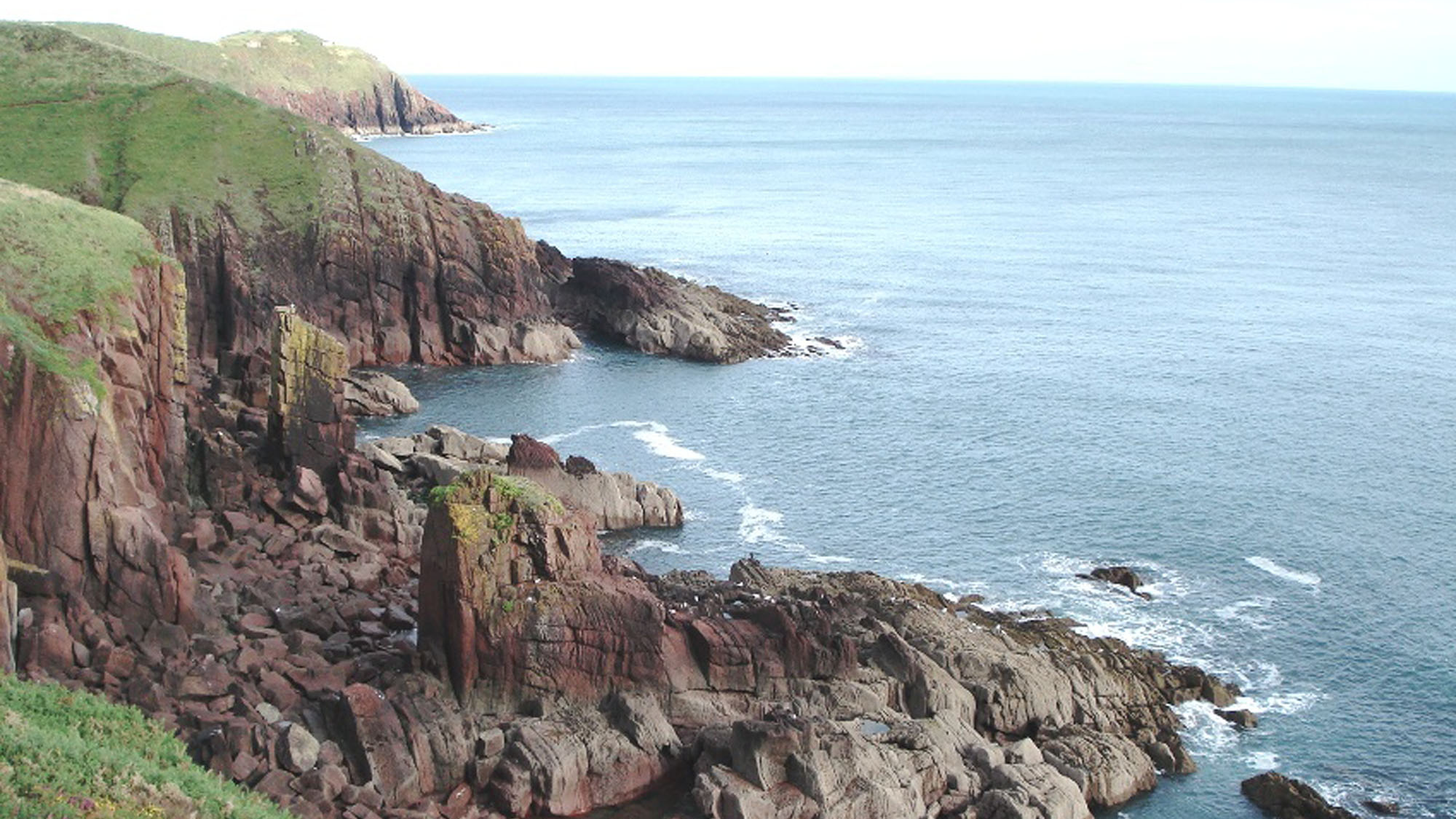
Overview
Directions
- Use the signed beach car park at Manorbier and follow the main access track towards the bay. Seasonal parking charges apply; check the signs on arrival rather than relying on older descriptions of free parking.
- The stream reaches the northern side of the beach. The approach to the beachhead platform can be rough and includes short slopes; soft sand and pebbles lie beyond it.
- For the geological views towards King’s Quoit, follow the waymarked public Coast Path. Keep to the path around Priest’s Nose, where the National Park warns of a deep concealed fissure.
- Beach reference: SS058975. Original bay reference: 51.64340°N, 4.80869°W. Follow the signed car-park access rather than treating a general bay reference as a route.
Location photographs
Swipe to browse · Select a photograph to enlarge


Fossil Hunting
The most approachable search is among loose grey limestone pebbles around the stream and back of the bay. Wet surfaces often show pale crinoid fragments more clearly against the darker rock. Look for small discs, circular or star-shaped column sections and short jointed stems. These are pieces of stalked marine animals, rather than plants. Examine naturally exposed surfaces first and photograph interesting material with a scale.
The photographs and observations recorded for this guide also include corals, brachiopods and a trilobite tail. Treat these as finds from the loose limestone, not as a list of body fossils from the surrounding red sandstone. The source and age of every transported pebble have not been established, and an isolated fragment cannot safely be assigned to a particular offshore or upstream formation. The earlier report of occasional bone is not a confirmed identification of a named vertebrate from the bay.
The red-bed exposures offer a different kind of fossil hunting: recognising traces made by animals moving over or through sediment. Published work on the Rat Island Mudstone Member at Manorbier records Diplichnites gouldi trackways, sinuous Cochlichnus anguineus, burrows assigned to Beaconites barretti and Palaeophycus, tentative paired furrows called cf. Cruziana, and Paleohelcura tridactyla. The last consists of small grouped tracks rather than the preserved body of its maker. Tentative Selenichnites traces have also been described. Producer interpretations must remain separate from identification of the trace itself.
Search visually across bedding surfaces rather than looking only for isolated shapes. Repeated footprints, paired grooves or an organised winding trail are more informative than a single depression. Mudcracks, carbonate nodules and pale reduction spots can resemble fossils; their relationships to bedding and neighbouring structures help distinguish them. A photograph showing the whole surface, close detail and scale is far more useful than removing a small piece that loses this context.
At Priest’s Nose, the Rook’s Cave Tuff contains a separate assemblage including Diplopodichnus biformis, grooves, burrows and clusters of pellets. These belong to an ash-bed surface within the Moor Cliffs Formation, not to the Rat Island Mudstone Member. They are scientifically valuable in place. Observe from a safe, permitted route without hammering or prising apart the tuff, and do not enter the narrow coastal clefts to follow a layer.
Historical records of shells in cemented raised-beach shingle are another separate part of the coast’s history. They do not turn the red beds into a marine shell-bearing formation, and the early Survey description does not guarantee that the same patches are exposed today. Concentrate on recording what is actually visible, with the rock type and precise setting kept alongside the identification.

Fossil photographs
Swipe to browse · Select a photograph to enlarge


Discoveries and milestones
Significant discoveries and geological research at Manorbier Bay.
1921 – Survey records and coastal sections
Dixon’s memoir documented local strata, open identifications of animal tracks and museum registers, together with a separate raised-beach shell record. The date is publication of the account, not a claimed first discovery.
1982 – Measured volcanic markers
Williams and colleagues described the Priest’s Nose tuffs, calcrete and sandstone markers, recording their individual thicknesses and offsets above the Rook’s Cave Tuff.
2004 – Terrestrial trace-fossil study
Morrissey and Braddy described the Manorbier trackways and burrows and reported Paleohelcura tridactyla as the first Welsh Old Red Sandstone record known to their study. Specimens and latex peels were reported deposited in Bristol; this does not establish individual collection dates.
2005 – Conservation-review synthesis
The Geological Conservation Review brought together the bay’s formation boundary, calcretes and nearby volcanic marker beds, while distinguishing the neighbouring coastal sections.
2015 – Modern stratigraphic framework
The BGS regional framework placed the succession within the Daugleddau Group and Milford Haven Subgroup, distinguishing modern ranks from older group terminology.
2024–2025 – Why the red beds are red
Bábek and colleagues published a study of mineral alteration, soil development and colour in separate Manorbier and Llansteffan sections. It appeared online in November 2024 and in the 2025 journal issue; its analytical samples are not newly discovered fossil vouchers.
Geology
Manorbier’s dramatic cliffs expose continental deposits laid down by rivers and on floodplains during the late Silurian and Early Devonian. Sandstones record sediment carried through channels, while the finer red beds represent quieter floodplain accumulation, ancient soils and repeated changes in drainage. Later deformation tilted much of the succession steeply, so a walk along the coast can cross beds that originally lay much closer to horizontal. Faults and folds complicate this pattern, and the separate bay and headland exposures should not be treated as one uninterrupted measured section.
In the modern BGS framework these rocks belong to the Daugleddau Group and its Milford Haven Subgroup. The Moor Cliffs Formation includes red, soil-modified mudstones, sandstones and volcanic ash beds, with the Chapel Point Limestone Member forming an important calcrete unit near its top. The succeeding Freshwater West Formation contains the Conigar Pit Sandstone Member below the Rat Island Mudstone Member. Older references use Milford Haven Group and Chapel Point Calcretes Member; these are historical terminology, not additional units to stack into the succession.
Near King’s Quoit, a thick purple calcrete and the quartz-pebble conglomerate above it make the formation boundary particularly striking. Calcrete is carbonate accumulated in ancient soils, often with nodules, cracks and irregular structures. Its cavities and rounded patches can easily be mistaken for animal remains. Further around Priest’s Nose, volcanic ash preserved as tuff provides distinctive marker beds among the floodplain deposits. The heights of these markers above the Rook’s Cave Tuff are measured offsets, not the thickness of each ash bed or distances above the formation base.
Modern research into the colour of these rocks links much of their reddening to iron-bearing minerals altered during soil formation and very shallow burial, followed in places by erosion and redeposition of already red sediment. Some grey areas may have escaped reddening, while other pale contacts reflect later bleaching. Colour alone therefore cannot identify a fossil, establish an exact age or prove a particular environment. Published research windows in the bay and at Priest’s Nose have separate starting points and cannot be added into a single local formation thickness.
The loose grey limestone pebbles searched for crinoids are separate from this red-bed story. Likewise, historical raised-beach shingle and blown sand belong to much younger superficial deposits. Keeping bedrock, transported stones and superficial material distinct is essential when recording a find or comparing it with a published fossil occurrence.

Detailed geology and bed-by-bed succession
Detailed geology and stratigraphy of Manorbier Bay.
DAUGLEDDAU GROUP
MILFORD HAVEN SUBGROUP
Scope, age and datums. The succession below is described from older to younger. Moor Cliffs Formation spans late Silurian Přídolí to earliest Devonian Lochkovian in the regional framework; Freshwater West Formation is Lochkovian. Those formation-scale ages do not independently locate the Silurian–Devonian boundary on every local surface. Priest’s Nose, King’s Quoit and the bay’s analytical sections are separate exposures with different reference levels. No complete local thickness of either formation is established here.
Moor Cliffs Formation
Priest’s Nose floodplain deposits. Steeply inclined red mudstones are modified by carbonate-rich soils and interbedded with fine- to medium-grained sandstone and volcanic ash. Williams’s local account describes Rook’s Cave Tuff on the south side of the platform and small faults that offset its continuation along strike. Ash accumulated unevenly in channels and depressions, so a thickness measured at one exposure need not apply everywhere.
Rook’s Cave Tuff: 0.68 m in the 1982 Priest’s Nose account. The lower surface carries grooves or brush-like markings, burrows and pellet clusters, especially in thicker channel fills. The later trace-fossil study describes four Diplopodichnus biformis trails here. Latex peel BRSUG 26990 illustrates one: the widest trail has ridges 3–4 mm wide, external width 19 mm, internal width 13 mm and preserved length 270 mm. Other trails are 8–11 mm wide, with one individually 340 mm long. Some traces occur 10 mm above the tuff base; a further 22 mm-wide trail leads to a 45 × 35 mm elliptical burrow.
Other tuff-surface structures. Grooves reach 50 mm wide and 400 mm long, while pellets reach 12 mm. Feeding or ploughing behaviour and current transport of pellets are alternative interpretations discussed by the authors. They do not identify a preserved body of the trace-maker. These records are distinct from both the Rat Island assemblage and the genus-level trail figured from Freshwater East.
Marker sandstones and calcrete. Between Rook’s Cave Tuff and the prominent higher calcrete, Williams records a lower green cross-bedded sandstone 1.40 m thick and an upper purple sandstone 1.28 m thick. Both are micaceous, fine- to medium-grained rocks, but exact heights above the tuff are not supplied. The massive calcrete is 2.95 m thick and lies 54.98 m above Rook’s Cave Tuff. Its lower part contains large carbonate concretions and mudstone boxwork; the upper part shows pseudoanticlines, soil-related structures that should not be mistaken for a new regional fold datum.
Townsend Tuff. At Priest’s Nose it is 2.44 m thick and lies 92.79 m above Rook’s Cave Tuff. The GCR synthesis distinguishes three graded ash falls, A, B and C, with crystal-rich lower parts grading into fine porcellanous material. Falls B and C are respectively 1.17 m and 1.10 m in this section; subtracting these from the total leaves 0.17 m for A, a derived figure rather than an additional independently quoted bed measurement. Fall C has an irregular erosional base, whereas A has a sharp non-erosional upper surface with faecal debris.
Pickard Bay Tuff and separate comparison sections. Williams gives Pickard Bay Tuff as 1.02 m thick at 108.62 m above Rook’s Cave Tuff. The GCR also summarises research windows extending about 25 m below to 50–60 m above Rook’s Cave Tuff, and another examined 17 m below to 69 m above at a site 40 m west of the cave. These are differently defined published study windows, not lengths to combine. GCR reports six tuffs in a 60 m interval above Rook’s Cave Tuff. The larger Townsend measurements and surface structures at East Moor Cliff and Old Castle Head are neighbouring comparisons, not extra Priest’s Nose beds.
Modern M3 research window. Bábek and colleagues report a 34 m Moor Cliffs section, while their plotted M3 graphic reaches approximately 31 m. Its Rook’s Cave tuffite is about 0.5 m thick and locally fills channels up to 1.2 m deep, alternating hard fissile pink porcellanite and red mudstone. This is a separate observation from Williams’s 0.68 m measurement. Sandstone and heterolithic packages recur among red mudstone and palaeosols; the article identifies grey or white sandstones around 16 m and 23 m. These approximate positions belong to the M3 datum, not the older tuff-referenced log.
Chapel Point Limestone Member
King’s Quoit boundary. The GCR records 10–15 m of massive purple, cavernously weathered calcrete near King’s Quoit at the southern end of the bay. It is overlain by a distinctive 1.5–2.2 m conglomerate containing angular quartz pebbles. The published photograph looks west-south-west across near-vertical beds, younging from left to right. The member was formerly called the Chapel Point Calcretes Member. Conigar Pit’s separate 11.2 m calcrete succession is not a replacement measurement for this bay.
Freshwater West Formation
Conigar Pit Sandstone Member
Lower river-deposit succession. Sandstone and conglomerate pass upward through finer deposits in repeated river and floodplain cycles. Near King’s Quoit the quartz-pebble conglomerate above the Chapel Point calcrete helps recognise the transition into the younger formation. Local beds are steeply inclined and affected by coastal structure; a regional formation thickness or Conigar Pit’s own measured fish horizons cannot be substituted for an uninterrupted Manorbier log.
Rat Island Mudstone Member
Trace-bearing surfaces. Morrissey and Braddy’s local schematic represents approximately 5 m of calcretised mudstone with pseudoanticlines and drab haloes, medium cross-laminated sandstone, inclined heterolithic stratification and fine sandstone. Eight labels include two morphologies of Diplichnites gouldi, so they do not represent eight separately confirmed genera. Arrows identify observed surface relationships rather than surveyed fossil heights above a formation base.
Documented trackways and furrows. Manorbier specimens include Diplichnites gouldi type A, BRSUG 26981, and type B, BRSUG 26982–26983. These are trace forms, not two preserved animal species. The paper’s wider dimensional ranges include other localities and are not a census of this bay. Cf. Cruziana, BRSUG 26980b, consists of long paired furrows about 7.5 mm wide individually, 28 mm across externally and more than 600 mm long. The tentative qualifier is retained. Two local Cochlichnus anguineus traces are described: one is 70 mm long and 1 mm wide with wavelength 24 mm and amplitude 9 mm; the other is 1 mm wide with wavelength 12 mm and amplitude 3 mm.
Grouped tracks, burrows and resting traces. Paleohelcura tridactyla, BRSUG 26985, has series of two or three tracks in triangular groups, about 55° to the midline; the recorded series is 16 mm long, with stride 25 mm, external width 40 mm and preserved length 250 mm. Palaeophycus is illustrated by a 10 mm-diameter example, distinct from the much larger Conigar Pit specimens. Tentative Selenichnites, BRSUG 26986, includes examples 20 × 22 mm and 16 × 13 mm. Beaconites barretti is recorded in the member locally, but the paper’s principal measured burrow populations and statistical comparisons are from other sites.
A published identification mismatch. Striatichnium is labelled in the Manorbier schematic, whereas the systematic paragraph assigns its cf. Striatichnium material to Warley Point and Conigar Pit. BRSUG 26988 and the corresponding figured specimen are from Warley Point. The schematic label is therefore retained as a source discrepancy, not promoted to a securely identified local species or a Manorbier voucher. The 2004 paper reports physical specimens BRSUG 26980–26988 and latex peels 26989–26991 deposited at Bristol; that repository statement is not a current inventory check or a date of collection.
Modern M1 and M2 research windows. Bábek and colleagues describe separate true thicknesses of 32 m and 34 m in the Rat Island Mudstone Member. Neither begins at a demonstrated formation base. No complete bed-by-bed M1 or M2 log is established by the recovered figure set, so the analytical sample positions must not be turned into invented beds. Local microscopy includes M1 palaeosols at 1.1 m and 17.9 m, showing iron-rich matrix and alteration along mica cleavage. Main-figure captions place an M2 conglomerate at 33 m, but the relevant supplementary thin-section table labels it at 28 m; this unresolved mismatch is not silently corrected.
Red colour, soil formation and analytical limits
Hematite occurs in muddy matrix, altered mica and carbonate cement. The study interprets much reddening as a product of soil development and very shallow diagenesis, with subsequent reworking of red sediment. Grey spots may never have been red, and some permeable sandstone contacts show bleaching. The M3 palaeosol example at 30.3 m and the sandstone/red-sediment comparison at 8.3 m belong to that separate section. In the latter, grey sandstone has reported iron of 2.2–3.3 wt.% versus 3.9–8.3 wt.% in neighbouring red sediment; these sample analyses are not whole-bay composition or fossil predictions.
The research combines Manorbier and Llansteffan data. Its pooled bed-thickness ranges, mineral plots and inferred soil durations cannot be assigned to every local bed. Figures of Llansteffan’s 3.2 m reactivation surface and 5.5/8.5 m contacts are specifically excluded from the Manorbier log. The published supplementary arrays contain 467 reflectance rows, 43 SEM spots, 415 bulk-labelled rows and 146 further analytical spots. Methods quote 418 bulk samples; 412 rows have complete colour data, matching the figure-bin count numerically without proving its selection rule. A supplementary MB2 37 m label exceeds the stated 34 m window, and MB8.8 samples have unresolved numbered-section provenance. Missing values are not zeros and anomalous calibrated microanalytical values are not ordinary bulk mass fractions. Counts per second, concentrations and reflectance percentages are different measurements.
Historical records and younger superficial deposits
Dixon’s localities 3 and 4 record ‘tracks of crustaceans?’ with registers E.D. 1194–1197 / J.M. 747–750 and E.D. 1193 / J.M. 745–746 respectively. These are historical open identifications, not independent diagnoses of modern ichnospecies. His numbered geological groups also do not correspond automatically to modern formation boundaries. Fish and plant records in other columns of his regional table belong to their named neighbouring localities and are not transferred here.
The 1921 memoir describes fragmentary raised-beach platform remnants locally about 18 ft above the historical high-water mark. Water-worn blocks of cemented shingle contained oyster and a few other shells, including Astarte?, Mytilus edulis?, Pecten sp. and Patella sp., sometimes as casts; the register is E.D. 969–970. These are superficial shell records, not Old Red Sandstone fossils or a measured continuous modern deposit. Present exposure is unverified. A reported submerged forest was not exposed during the Survey’s work and supplies no local measured log here. Wind-blown sand moving inland from the bay is a further, younger surface process.
Sources. Dixon (1921), The country around Pembroke and Tenby, local records and coastal descriptions; Williams and colleagues (1982), local Old Red Sandstone sections; Morrissey & Braddy (2004), DOI 10.1002/gj.991; GCR 31 (2005), Chapter 5, pp. 302–305 and associated figures; BGS RR/14/02 (2015), modern stratigraphic framework; Bábek and colleagues (online 2024, issue 2025), DOI 10.1111/sed.13244, main article and supplementary tables. Older studies cited through GCR remain attributed secondary evidence rather than a claim that every underlying article was inspected.
Safety
Check tide times and sea conditions before approaching rocky margins, and retain a clear route back to the main beach. Wet rock and loose pebbles are slippery, waves can reach exposed platforms, and stream conditions vary after rain. Allow enough time to leave exposed areas before the tide rises.
Priest’s Nose has a deep concealed fissure specifically highlighted by the National Park. Stay on public paths, avoid cliff edges and narrow clefts, and take particular care in wind or wet conditions. Supervise children and dogs closely. Tell someone your route and expected return, as a usable mobile signal should not be assumed.
Equipment
A hand lens, camera, small scale and notebook are more useful than a hammer for this visit. Footwear with good grip helps on wet stones; take suitable weather protection and a means of communication. Do not prise apart bedrock, enlarge exposures or chip trace-bearing surfaces.
Cleaning And Treating
For material already lawfully collected, record the location and distinguish loose limestone from red-bed material before cleaning. Start with dry inspection and a soft brush. Weak mudstone and trace-bearing surfaces can crumble or lose important relief when soaked or scrubbed.
Avoid acid treatment: carbonate is part of the limestone, calcrete and cement, and dissolving it can destroy both fossil detail and geological context. Do not make casts, cut samples or use consolidants on protected in-situ surfaces without the appropriate permission. Seek specialist advice before attempting preparation of a fragile or potentially important specimen.
Identify Your Finds
Need help identifying a fossil? Share clear photos, where you found it and its size with the community.
Further Reading
Geological Conservation Review: Old Red Sandstone coastal sections
Morrissey & Braddy: terrestrial trace fossils
Bábek and colleagues: red-bed colour and soil development
National Park: Manorbier walks and headland warning
National Park: beach access
National Park: geological conservation and collecting guidance
Access Rights
The Manorbier coast is within the Freshwater East Cliffs to Skrinkle Haven SSSI. The National Park’s geological guidance asks visitors to photograph fossils and requires permission from Natural Resources Wales and the landowner before removing fossils or minerals from an SSSI. It specifically asks for written NRW permission for collecting undertaken for genuine scientific research.
Plan an observation and photography visit unless those permissions explicitly cover the material you intend to remove. Do not assume that a loose pebble, a public footpath or an earlier published collection grants collecting permission. Do not hammer, core or prise apart protected bedrock or trace-bearing surfaces; follow current notices and any local access restrictions.
It is important to follow our ‘Code of Conduct’ when collecting fossils or visiting any site. Please also read our ‘Terms and Conditions‘
Links
♦ Fossil Discussions
♦ Fossil Articles
♦ Buy Fossils, Tools and Equipment
♦ Buy Crystals, Meteorites, and Artefacts
♦ Join Fossil Hunts
♦ UK Fossils Network


