
Overview
Directions
- Seek permission before entering the pit. Neutral Farm lies east of Butley, beside the lane towards Butley Mills, with the old pit just south of the lane. Use the public footpath by the farm for the agreed approach, then enter only by the route the landowner has authorised. Ask where to park so that farm entrances, the lane and footpaths remain unobstructed. The locality reference is TM 3715 5105, approximately 52.10689°N, 1.46100°E. Do not cut through undergrowth or clear an exposure yourself.
Location photographs
Swipe to browse · Select a photograph to enlarge


Fossil Hunting
This classic Red Crag site is best known for marine shells rather than large vertebrate remains. Bivalves dominate many samples, with gastropods and occasional small teeth or bone fragments. The published historical assemblage includes Mytilus edulis, Scrobicularia plana and Serripes groenlandicus, together with other bivalves recorded under older names.
Freshwater and land molluscs are especially important: they are a small transported component in marine sediment and should not be confused with a freshwater origin for the whole deposit. Documented occurrences are associated with sediment above an internal erosional surface. Keep any permitted samples from different levels separate. Collect only where and as specifically agreed, favouring loose weathered material away from the face; do not remove vegetation or excavate a new section.
Fossil photographs
Swipe to browse · Select a photograph to enlarge


Discoveries and milestones
A chronological record of geological research and significant discoveries at Neutral Farm Pit, Butley.
1871 – Classic descriptions and fossil lists
Taylor, Bell and Prestwich described the pit. Bell’s account included 165 marine mollusc species and varieties, plus freshwater and terrestrial shells.
1948 – Butleyan type-locality interpretation
Ovey and Pitcher treated Neutral Farm as the type locality for Harmer’s historical Butleyan subdivision.
1954 – Initial scientific protection
Natural England’s citation records the first notification under the National Parks and Access to the Countryside Act 1949 in 1954.
1977–1979 – Depositional environments reconstructed
Dixon’s measured section and sedimentological interpretation distinguished tidal sandwaves below from a shallowing upper succession.
1985 – SSSI renotification
The pit was notified under the Wildlife and Countryside Act 1981 in 1985.
2017–2018 – Exposure management and field visits
GeoSuffolk reported clearing during the preceding winter and subsequent geological field-party visits in its 2018 conservation report. This was managed work, not general permission for visitors to excavate.
References
UK Fossils: Neutral Farm Pit, route and inspection year
Balson 1999: Neutral Farm Pit, GCR volume 15, pp. 315–317
BGS district explanation and 1982 Neutral Farm photograph
Natural England: Neutral Farm Pit citation
Natural England: Neutral Farm Pit SSSI
GeoConservationUK Autumn 2018: GeoSuffolk site management
Geology
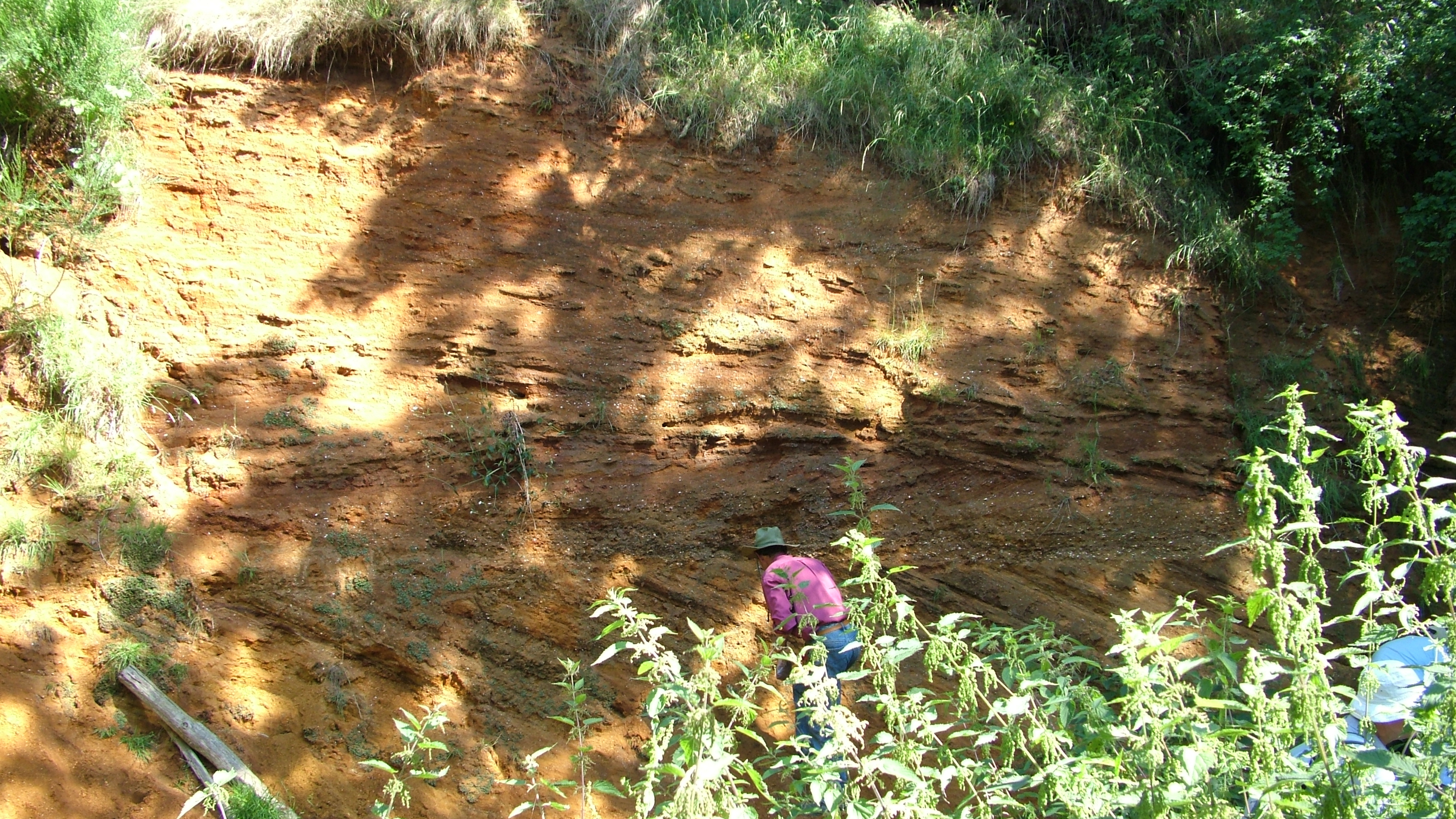
Neutral Farm preserves a changing shallow sea within the early Pleistocene Red Crag Formation. The lower part of the documented exposure consists of medium- to coarse-grained shell sand with strong cross-bedding. Its inclined layers dip south-west and contain alternating coarse and fine sediment, recording the migration of tidal sandwaves. Dixon interpreted these sands as having accumulated below low-tide level in about 10–20 m of water. Shells occur within this mobile sandy seabed rather than in a single undisturbed shell pavement.
A sharp erosion surface cuts off the lower cross-bedded package. Above it, burrowed sands with trough cross-bedding pass upwards into finer sand and laminated silt. The published interpretation is an overall shallowing sequence, with a clear change in sedimentary character rather than a newly named formal member at each transition. Rare non-marine shells have been attributed to sediment just above the erosion surface. Their recorded position matters: the complete historical fossil list should not be treated as a fauna present equally throughout the pit.
The sea was followed much later by a river environment. Overlying sandy gravel contains quartz and quartzite pebbles and has been linked to the ancient Thames system under the historical Kesgrave terminology. This cap is distinct from the marine Crag below, although its precise local subdivision remains uncertain. “Butleyan”, another name encountered in older accounts, is a historical faunal and age subdivision of the Crag rather than a separate formation. The detailed log describes past exposures; vegetation and slipped sand can hide the structures and contacts that explain the site.
Detailed geology and bed-by-bed succession
Detailed stratigraphy and geological evidence at Neutral Farm Pit, Butley.
CRAG GROUP
The shelly marine sands belong to the Red Crag succession.
Red Crag Formation
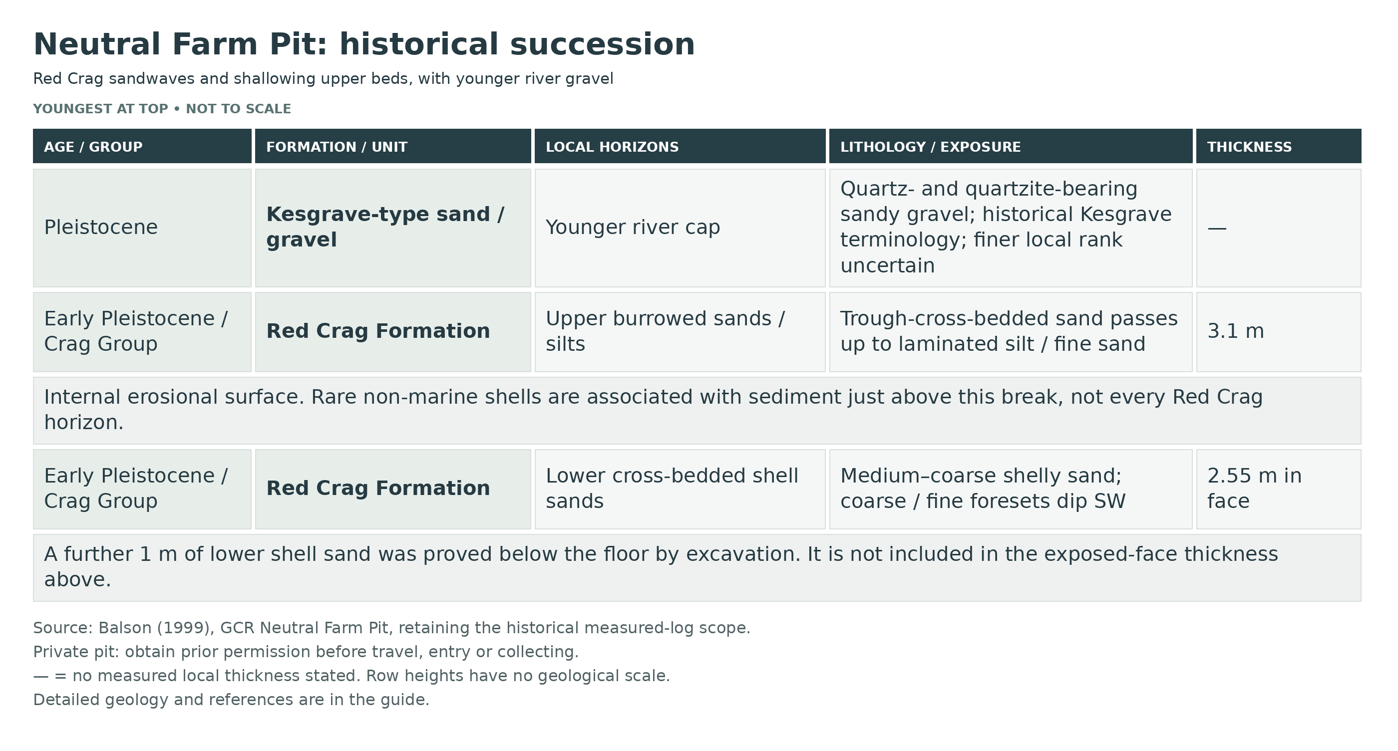
The detailed published section is historical: Dixon described more than 6 m, while exposures in the 1970s exceeded 7 m. Today’s vegetation or slips may conceal much of it.
Lower cross-bedded shell sands
The measured face contained 2.55 m of medium- to coarse-grained shelly sands; another metre was proved below the floor by excavation. Alternating coarse and fine foresets dip south-west. Dixon interpreted deposition by tidal sandwaves in about 10–20 m of water.
Internal erosional surface
A sharp truncation separates the lower cross-bedded package from the upper sands. The rare non-marine shells have been attributed to sediment just above this surface; the complete historical fauna must not be assigned indiscriminately to every bed.
Upper burrowed sands, silts and fine sands
The overlying 3.1 m begins with burrowed trough-cross-bedded sands and passes upwards into laminated silt and fine sand. The change is interpreted as an overall shallowing sequence. It is an informal sedimentary division, not a demonstrated formal member.
Kesgrave sands and gravels — historical terminology
Sandy gravel with quartz and quartzite pebbles overlies the Red Crag. The GCR account recognised the Kesgrave affinity, representing younger river sediment. The quartz-rich composition links this cap to the ancient Thames river system; its precise local subdivision remains uncertain.
References
UK Fossils: Neutral Farm Pit, route and inspection year
Balson 1999: Neutral Farm Pit, GCR volume 15, pp. 315–317
BGS district explanation and 1982 Neutral Farm photograph
Natural England: Neutral Farm Pit citation
Natural England: Neutral Farm Pit SSSI
GeoConservationUK Autumn 2018: GeoSuffolk site management
Safety
Loose sandy faces, old slips and vegetation are the main hazards. Stay back from overhangs and the quarry rim; do not work beneath or undercut a face. Hidden uneven ground and brambles can make the approach difficult. If the authorised collecting area is overgrown or unstable, use an observational visit or postpone rather than clearing a route yourself.
Equipment
Bring boots, a hand lens, labels, a camera and padded specimen boxes. Any trowel work, sieving or sediment sampling requires explicit agreement for that visit. No hammer is needed to examine loose shells.
Cleaning And Treating
Keep each permitted specimen with its locality and bed information. Support fragile shells or bryozoans in tissue inside a rigid box. Allow damp specimens to dry slowly away from heat, then begin with a soft brush. Do not force compacted sand from delicate shell edges. Avoid acids, bleach and varnish. If an exceptionally fragile specimen needs consolidation, seek advice before using a reversible conservation adhesive such as Paraloid B-72; routine coating is unnecessary.
Identify Your Finds
Need help identifying a fossil? Share clear photos, where you found it and its size with the community.
Further Reading
Neutral Farm Pit: Geological Conservation Review account
BGS geology of the Woodbridge and Felixstowe district
Natural England: Neutral Farm Pit SSSI citation
Access Rights
This is private land. Arrange permission from the landowner or operator before entering the pit, including agreement on the approach, parking and any collecting. A public path nearby does not give permission to enter the excavation. Follow the visit organiser’s conditions; permission for a visit is not automatically permission to dig, clear vegetation or take bulk samples. Neutral Farm Pit, Butley is a geological SSSI (Natural England site S1000781). Its public-path setting does not give an automatic right to enter or excavate the quarry. Follow the landowner’s conditions and the relevant conservation consents.
It is important to follow our ‘Code of Conduct’ when collecting fossils or visiting any site. Please also read our ‘Terms and Conditions’.
Links
♦ Fossil Discussions
♦ Fossil Articles
♦ Buy Fossils, Tools and Equipment
♦ Buy Crystals, Meteorites, and Artefacts
♦ Join Fossil Hunts
♦ UK Fossils Network


