Overstrand’s shore is best explored for loose Chalk fossils and the changing exposures revealed when sand is washed away. Echinoids, belemnites, brachiopods and sponge remains occur in chalk and flint, while rarer mammal fossils record a much younger Pleistocene landscape. The cliffs also contain chalk rafts displaced by ice, an important reminder that the visible rocks are not always in their original order. Fossils may show both ancient features and much younger marine borings. Access is affected by coastal works and erosion, so check the current route before travelling and leave ample time to return on the falling-tide beach.


FIND FREQUENCY: ♦♦♦♦♦ Fossils occur in loose beach material, but shifting sand and recent erosion strongly affect what is exposed.
CHILDREN: ♦ The exposed collecting section is unsuitable for young children: unstable cliffs, tidal obstructions and a potentially long return require particular care.
ACCESS: ♦♦ Use established Overstrand access and check current works and closures. The collecting shore is uneven and tide-dependent; do not rely on climbing the cliffs as an exit.
TYPE: Cliff geology and loose foreshore material.
DIRECTIONS
♦ Reach Overstrand from Cromer via the B1159. The council car park is on Pauls Lane, NR27 0PE, with a grass surface and toilets nearby. Use the established signed public routes towards the promenade and beach; do not rely on an old cliff path shown in an earlier guide.
♦ Access checked October 2026: coastal-management works are affecting the promenade and beach approaches. The council’s September update states that the western zigzag and far-western beach access, together with the Clifton Way beach ramp, are to remain available, while the eastern zigzag and an adjoining promenade section close during the relevant works phase. There is no through-route between the east and west promenades at high tide during these works. Check the current council scheme updates and follow on-site diversions.
♦ Explore the foreshore near Overstrand only where an unobstructed low-tide route remains. Chalk rafts east of the village and chalk-bearing shore west of it are different exposures; the more distant Sidestrand and Trimingham sections are separate localities, not an extension that should be attempted without its own tide and access plan.
♦ What3Words collecting area: ///self.mega.crib

A FIELD GUIDE TO COLLECTING BRITISH CENOZOIC FOSSILS
by Steve Snowball & Alister Cruickshanks
£21.99 (PAPERBACK)
FULL COLOUR – 190 PAGES
Available worldwide exclusively through Amazon
- Fossil identification plates
- Stunning locality and fossil photos
- Up-to-date geological & site information
- Best fossil-bearing sites in southern and eastern Britain described in detail
- Illustrations of life in deep time by Andreas Kurpisz
FOSSIL HUNTING
Begin with the loose chalk and flint. Search shingle patches for echinoid tests, their flint internal moulds, belemnite guards and fossil-bearing cobbles. Fossils may be worn smooth or preserved only as part of an imprint. Sand can hide the most productive ground for long periods. The value of a visit lies in careful observation, not an expectation that every tide will expose a rich collecting surface.
The Overstrand chalk masses have documented Echinocorys, including specimens compared with Echinocorys belgica, the crinoid Austinocrinus bicoronatus, brachiopods and belemnites. The fossil-rich hard chalk traditionally called the Pyramidata Hardground is associated with Echinocorys pyramidata. Do not assume that every loose Echinocorys belongs to that species: shape, preservation and original horizon all matter.
Scientific records versus beach identifications. The Overstrand succession includes Belemnitella and, in higher beds, Belemnella, including records of Belemnella lanceolata. Specialist studies also distinguish tiny brachiopods such as Rugia and Trigonosemus. These records underpin geological correlations; most worn beach specimens are more safely labelled by fossil group or genus than forced into a species identification.
Younger mammals and transported rocks. Bones, teeth and antler may be released from Pleistocene deposits or moved along the beach. The historical Overstrand fauna includes the type specimen of the bovid Caprovis savinii, described from a horn-core collected by Alfred Savin. Its exact original bed is uncertain, so it should not be assigned confidently to a particular modern member. Other occasional mammal remains require the same caution. Erratic pebbles can contain fossils older than the local Chalk, but are transported finds rather than evidence for an exposed local Carboniferous or Jurassic formation.
Examine holes and encrustations as well as the main fossil. Ancient echinoids and chalk clasts have been re-bored by much younger marine organisms; modern sponge borings such as Entobia can overprint a Cretaceous fossil. Preserve these relationships. Photograph an unusual find before cleaning and record whether it was loose, attached to chalk or visibly within an exposed bed.


A chronological record of fossil discoveries, geological research and conservation milestones at Overstrand.
1882 – A new bovid described
Edward Tulley Newton named Caprovis savinii from a horn-core obtained by Alfred Savin at Overstrand. The specimen became the species’ holotype, although its precise bed of origin remains uncertain.
1906–1908 – Overstrand chalk masses documented
R. M. Brydone described the chalk masses and drew attention to their fossil assemblages, including Austinocrinus bicoronatus. These observations helped relate Overstrand’s chalk to the younger-looking sections farther along the coast.
1967 – Hotel chalk masses differentiated
C. J. Wood distinguished an Overstrand succession below the traditional Porosphaera Beds, using the combined occurrence of Belemnitella and Belemnella in the hotel-area masses.
1983–1984 – Boundary correlations developed
Studies of foraminifera and other fossils used the Overstrand succession to investigate the Campanian–Maastrichtian transition and correlate the onshore record with the southern North Sea basin.
1990 – Sidestrand Chalk Member applied
M. B. Johansen and Finn Surlyk’s stratigraphic study brought the Overstrand composite chalk succession into the Sidestrand Chalk Member, clarifying the relationship between local names and fossil zones.
1992 – Cliffs re-notified for conservation
An enlarged Overstrand Cliffs SSSI was notified, protecting important soft-cliff habitats as well as exposures relevant to the glacial history of the coast.
2006 – The Overstrand bovid revisited
New North Sea horn-core discoveries prompted reassessment of Caprovis savinii and the likely Early Pleistocene age of the Overstrand type specimen. They did not resolve its exact original bed.
2009–2011 – Chalk rafting examined in detail
Structural studies investigated the Overstrand chalk rafts and their underlying shear zones, refining models of ice-marginal thrusting, transport and emplacement.
2011 – Ancient fossils shown to host modern borers
Research on Overstrand beach echinoids examined how Cretaceous skeletons became hard surfaces for much younger marine organisms. This demonstrated why apparently minor borings can be an important part of a fossil’s history.
GEOLOGY
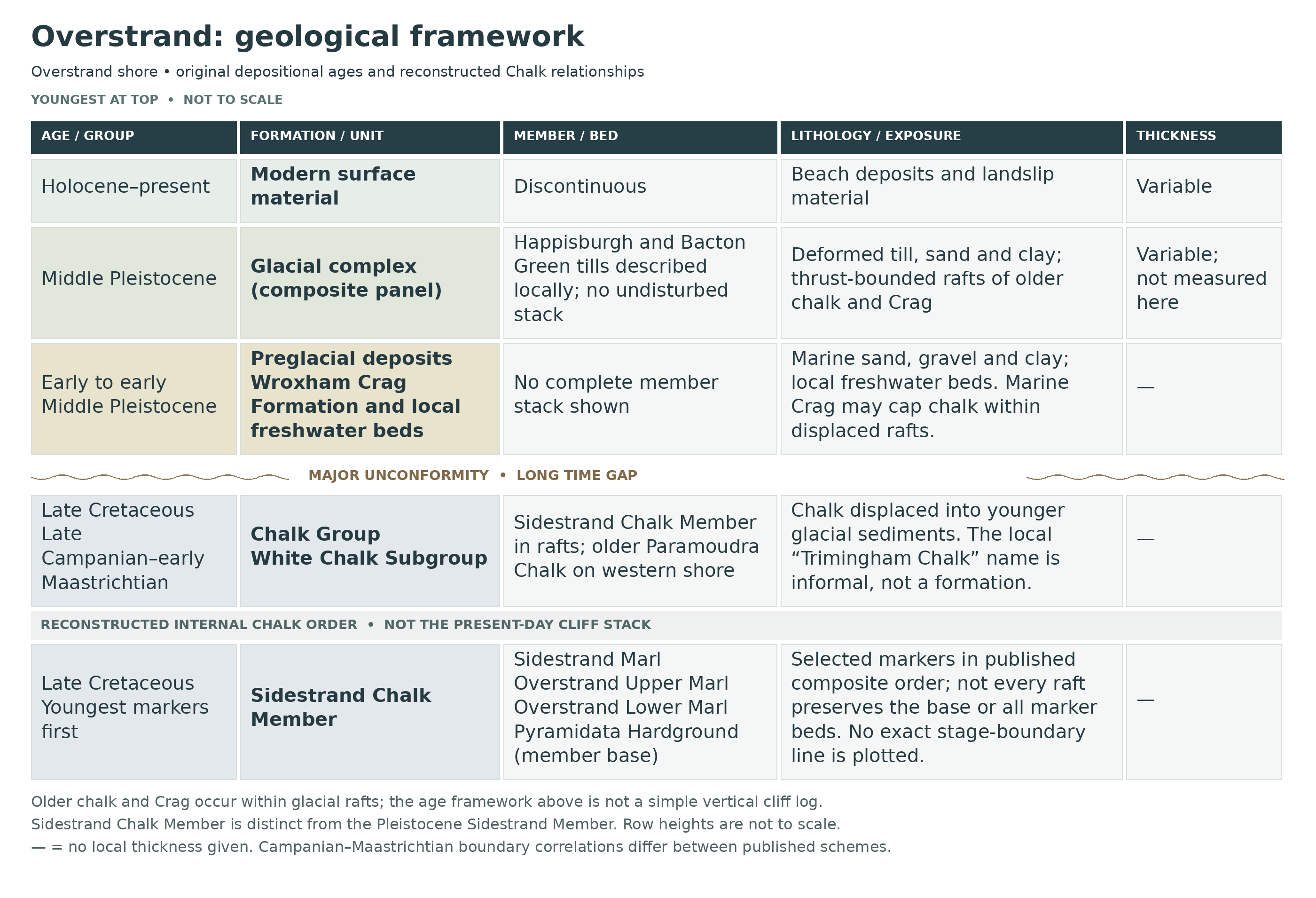
The original Chalk sea. The local Chalk Group records Late Cretaceous marine deposition. Near Overstrand the preserved rocks approach and cross the traditional Campanian–Maastrichtian boundary interval. Fossil assemblages, flint bands, marl seams and hardgrounds help relate separate exposures; a named fossil horizon should not be treated as a simple visible line across the entire modern cliff.
The foreshore west of Overstrand includes the highest locally recognised in-situ Paramoudra Chalk and the fossil-rich Pyramidata Hardground. The chalk masses around the former hotel area expose the overlying Sidestrand Chalk Member in the regional literature. Despite its name, that member is present at Overstrand; it must not be confused with the much younger Sidestrand Member of the Wroxham Crag Formation.
Ice moved the rocks. Later Pleistocene glaciers detached large slabs of chalk and their preglacial cover, moving them into younger glacial sediments. Modern research describes thrust-bounded rafts and several phases of deformation. The mass of white chalk high in a cliff is therefore not proof that chalk was deposited above the tills. Distinct rafts can preserve original chalk–Crag contacts internally while being displaced as a whole.
Marine and estuarine Crag sediments, freshwater deposits and later tills, sands and lake sediments record changing Pleistocene environments. Their distribution is irregular and often hidden by beach sediment or landslips. Use Wroxham Crag Formation for verified marine Crag, and reserve Cromer Forest-bed Formation for freshwater deposits rather than applying the old broad “Forest Bed” name to every preglacial layer.


Detailed geology and stratigraphy of Overstrand.
Local sections rather than a single cliff column
The western shore, hotel-area chalk masses and preglacial sediments expose different parts of the record. Original Chalk marker order can survive inside a displaced slab, while the slab itself rests among much younger deposits. The sections below separate internal stratigraphy from later glacial emplacement.
Chalk Group
The chalk records Late Cretaceous marine deposition. White carbonate mud, shells, flint horizons and marls provide the local sedimentary framework.
White Chalk Subgroup
Upper Campanian and Lower Maastrichtian intervals occur around Overstrand. BGS retains informal nomenclature for the younger north Norfolk chalk; no formal Trimingham Chalk Formation is imposed here.
Paramoudra Chalk Member: western foreshore
The older western shore chalk contains large flints and indurated horizons. It precedes the Sidestrand Chalk Member in the regional composite sequence. Individual specimens loose on the beach do not establish which member they originally came from.
Overstrand Pyramidata Hardground
This hard chalk and fossil concentration includes Echinocorys pyramidata. It marks the top of the Paramoudra Chalk in the local scheme. The known foreshore occurrence is west of the promenade approach; it should not be inserted at the visible base of every hotel-area raft.
Sidestrand Chalk Member: Overstrand Hotel Lower Mass
The following markers are in ascending order in the published Mass 1 log. They are not separate formations or a current exposure guarantee.
Historically exposed lower marl
GCR records an additional unnamed marl below the Overstrand Lower Marl. It was already buried when that account was prepared; its exact thickness and present visibility are not assumed.
Overstrand Lower Marl
A marl seam forms the lowest named marker in the logged mass.
Lower paramoudra-bearing interval
Large vertical flint occurs between the Lower and Upper Overstrand marls.
Overstrand Upper Marl
Pyrite nodules accompany this marl. Its microfossil change has served as a traditional boundary-correlation marker.
Inoceramid-bearing chalk
An inoceramid shell horizon lies above the Upper Overstrand Marl in the published section.
Echinocorys band
A separate echinoid-rich horizon lies higher, beneath the Sidestrand Marl.
Sidestrand Marl
This pyrite-bearing seam provides an important tie with the chalk masses at Sidestrand.
Higher paramoudra interval and oxidised nodules
The overlying flinty chalk contains another paramoudra horizon and higher limonitised pyrite nodules.
Near-semitabular flint and mixed belemnite interval
Above the prominent flint, Belemnella joins Belemnitella. This is higher than the traditional marl-based stage marker.
Upper chalk surface and Crag cap
Preglacial Crag truncates the top of the documented chalk mass across a major time gap.
Mass 2: former Upper Mass and lower continuation
The former Overstrand Hotel Upper Mass was a highly fossiliferous 3 m section at the eastern end of Mass 2; GCR records that it had slipped away and broken up. About 2 m of chalk was visible beneath the Sidestrand Marl in Mass 2, with the downward continuation hidden by talus. These are historical mass-specific observations, not a measured extension of every Mass 1 marker.
Mass 3: chalk above the Sidestrand Marl
The separately described Mass 3 had the Sidestrand Marl at its base and exposed higher chalk. Its partial section is not evidence of a complete underlying succession at that position.
Mass 4: channel truncation and folded marl
A channel cut the eastern side of this separate chalk mass and was filled with flint cobbles above basal shell debris. A marl within the chalk, inferred to be the Sidestrand Marl, showed intra-Chalk folding. Both the correlation and the historical exposure limits remain qualified.
Stage boundary and thickness cautions
The local marker succession is more secure than a single unqualified line for the modern Campanian–Maastrichtian boundary. Published fossil schemes use different events. Bed thicknesses have not been read off a scaled diagram as if they were exact field measurements; the names refer to the logged mass, not to all rafts.
Crag Group
Marine preglacial sediments can occur in their original relationship above the Chalk within a raft. Their present altitude is not their original depositional level.
Wroxham Crag Formation
Sand, gravel and fine sediment record preglacial coastal deposition. Historic “Forest Bed” terminology also included marine beds; those labels must not automatically be interpreted as the freshwater Cromer Forest-bed Formation.
Chalk–Crag contact within raft OS-A
The eastern studied raft preserves bedded sand and gravel on chalk, with their internal bedding broadly parallel. The research measured more than 5 m of Crag above approximately 4 m of chalk at its eastern end; these are local raft measurements.
Chalk–Crag package within raft OS-B
The larger raft preserves about 10 m of chalk beneath more than 5 m of Crag. Folding, a basal thrust and a reverse fault deform the package. Those thicknesses describe OS-B, not the whole Overstrand chalk or Crag succession.
Albion Glacigenic Group
Ice movement incorporated the earlier rock and sediment into a younger glacial complex. Structural labels OS-A, OS-B and OS-C identify studied rafts, not depositional members.
Happisburgh Glacigenic Formation
The basal local glacial deposits include till traditionally called the First Cromer Till. Modern formation names distinguish this deposit from later tills rather than treating the entire cliff as one Cromer Till.
Happisburgh Till Member
In the studied Overstrand raft package, till overlies the marine Crag and carries much of the recorded deformation. Its presence and structural contacts are documented, but no universally applicable thickness is assigned to this variable, displaced section.
Sheringham Cliffs Formation — BGS framework
BGS places the Bacton Green Till Member in this formation. This is the selected lithostratigraphic framework; the entire regional member succession is not asserted to be visible at Overstrand.
Bacton Green Till Member
The unit comprises stony diamicton with sorted sand, silt and clay interbeds. Limited exposures occur above the earlier till in the published local description. Its original bedding has been affected by folds and detachments, so a thickness from Bacton Green’s type section would be inappropriate here.
Basal raft shear zones
The Overstrand research distinguishes reverse faults, shearing and water-rich deformation at raft bases. These are structural boundaries formed during transport, not extra sedimentary beds. Some original contacts within the slabs remain recognisable while their lower surfaces cut across older sediment.
Later tectonostratigraphic interpretation
The 2017 framework places the Overstrand raft stack within a later deformation episode affecting pre-existing glacial and preglacial sediment. This complements the lithological descriptions above but should not be converted into another vertical formation stack. Modern landslide slip surfaces can further complicate the visible contacts.
References
Mortimore, Wood and Gallois (2001). Overstrand to Trimingham Cliffs, GCR23; figure4.32 and Overstrand account.
BGS. Chalk stratigraphic framework RR/05/01.
BGS Lexicon. Informal Trimmingham Chalk.
Vaughan-Hirsch and colleagues (2011). Glacitectonic rafting of chalk bedrock: Overstrand, especially sections3.2–3.3.
BGS Lexicon. Wroxham Crag Formation.
BGS Lexicon. Bacton Green Till Member.
Lee and colleagues (2017). Middle Pleistocene glacial evolution of northern East Anglia.
SAFETY
Coastal works can close short sections of promenade or access slope and introduce moving vehicles. Check current notices before descending, obey barriers and use the marked public route. Do not climb rock armour, groynes or a closed slope to bypass a restriction.
The collecting shore may narrow or disappear as the tide rises. Work out the safe return route before searching, allow for waves and wind, and turn back early. Soft mud around slips, slippery chalk and algae-covered flints make footing unpredictable. Keep clear of the cliff base and overhangs; rain and storms can trigger fresh falls, and apparently solid chalk rafts are not safe shelter.
EQUIPMENT
Take reliable tide information, a charged phone, grippy footwear, hand lens, camera and padded specimen boxes. Loose-beach collecting needs no hammer. Labels and photographs preserve the distinction between chalk fossils, mammal material and transported pebbles much better than a bag of unrecorded finds.
CLEANING AND TREATING
Start with photographs and minimal soft brushing. Retain chalk around a delicate shell or sponge rather than trying to expose every surface. Hard flint enclosing an echinoid cannot safely be split simply to free the fossil; a partial specimen or mould may be the best preservation achievable.
Use gentle fresh-water cleaning only for sound material, and avoid soaking fragile bone, cracked teeth or friable chalk. Dry stable wet specimens gradually. Leave recent borings, attached shells and encrustations intact until their significance is understood: they can tell a second geological story. Never use acids, bleach or routine varnish. Seek specialist advice before preparing an important mammal find or consolidating weak material.
Identify your finds
Need help identifying a fossil? Share clear photos, where you found it and its size with the community.
FURTHER READING
Deposits Magazine: the beach from Overstrand to Cromer
Deposits Magazine: Norfolk fossil locations, a personal view
JNCC: Overstrand to Trimingham Chalk succession
Glacitectonic rafting of chalk bedrock at Overstrand
Geological Society: Overstrand glacial deformation
JNCC: Overstrand Cliffs protected habitats
Council: current Overstrand coastal works and access
Norfolk Museums and council: responsible fossil collecting
ACCESS RIGHTS
Protected areas on this coast have distinct boundaries. Overstrand Cliffs SSSI and SAC cover the soft cliffs towards Cromer; the Sidestrand and Trimingham Cliffs SSSI protects much of the coast eastwards. Follow the applicable signs and landowner conditions rather than assuming one designation grants collecting rights along the whole shore. Restrict ordinary collecting to permitted loose beach finds and obtain the relevant permissions before disturbing any protected exposure. Current construction closures must also be respected.
It is important to follow our ‘Code of Conduct’ when collecting fossils or visiting any site. Please also read our ‘Terms and Conditions‘
LINKS
♦ Fossil Discussions
♦ Fossil Articles
♦ Buy Fossils, Tools and Equipment
♦ Buy Crystals, Meteorites, and Artefacts
♦ Join Fossil Hunts
♦ UK Fossils Network