
Overview
Directions
- Approach Carlops on the A702 and use the small former-quarry village car park. Its published parking postcode is EH26 9NH; follow the signs and current notices on arrival.
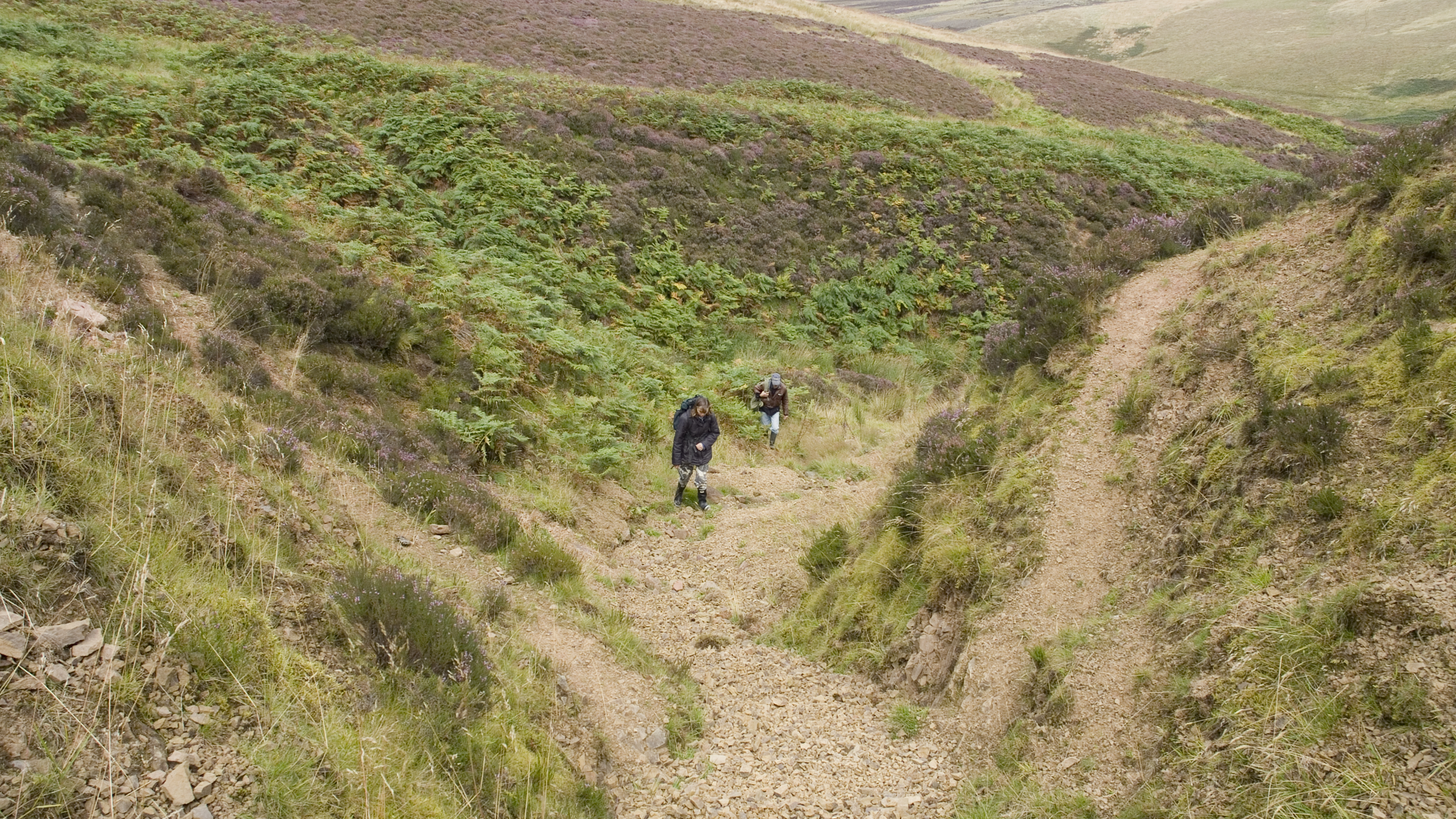
- From the southern side of the village, take the narrow road west on the uphill bend, passing the water-treatment works and Fairliehope. Continue on foot as the road becomes the rough track towards North Esk Cottage and the reservoir. Do not drive the hill track without specific permission.
- Allow for roughly 3 km on the historical walking approach to the reservoir, before exploring the more demanding burn sections. Carry a suitable map: the reservoir path does not provide a maintained route to every exposure.
- The guide concerns the River North Esk, Deerhope Burn, Cock Rig, Wether Law Linn and Henshaw Burn. Gutterford Burn is retained for its scientific history but is not recommended as a collecting stop.
- Locality reference: 55.80687°N, 3.35177°W. This is the original locality reference, not a car-park entrance coordinate.
Location photographs
Swipe to browse · Select a photograph to enlarge


Fossil Hunting
Begin by distinguishing the fossiliferous fine-grained rocks from the much coarser sandstone and conglomerate. The best-documented shelly faunas occur in parts of the Deerhope and Wether Law Linn formations, rather than uniformly through every burn. Weathered siltstone surfaces can reveal shell impressions and scattered skeletal fragments, while thin coarser layers may contain concentrations of broken shells. Inspect accessible natural surfaces and loose material where it lies, using a hand lens and photographs with a scale. Taking even loose fossils requires permission; the access section explains the additional checks needed on protected ground.
Deerhope Burn is a useful focus for understanding the varied marine fauna described in this guide. Its predominantly fine, laminated or burrowed sediments contain thin fossil-rich concentrations known collectively as the Deerhope Coral Beds. These are shelly layers rather than a continuous coral reef. Corals occur with brachiopods, bivalves, trilobite remains and crinoid debris, so a fossiliferous piece should be examined on more than one surface. A coral may show closely packed tubes or a cup with internal partitions; a crinoid fragment is more likely to consist of small plates or a short stack of stem discs. Broken material can be informative without allowing a species-level identification.
Brachiopods are particularly important here. Their two-valved shells are easily confused with bivalves, but a brachiopod commonly has a line of symmetry down each valve, whereas the two sides of a bivalve shell need not be symmetrical in that way. The Deerhope Coral Bed supplied the holotype of Isorthis (Ovalella) clarksoni. This is a securely documented scientific occurrence, not a suggestion that every small ribbed shell belongs to that species. Shell shape, ribbing and the hinge region all matter; incomplete external moulds may be best recorded simply as brachiopods.
The River North Esk exposes a different, higher Deerhope shell-rich horizon historically called Lamont’s bivalve bed. It should not be confused with the coral beds in Deerhope Burn. Older accounts emphasise shell-rich siltstone, while a 2011 study describes mainly grey sandstone at the bivalve locality. Crinoid stems from loose rock associated with this locality were used to describe the columnal form Pentagonocyclicus (col.) lamonti. Individual stem discs are parts of an animal, not complete crinoids; retaining an association of discs, shell fragments and surrounding matrix is more useful than isolating each attractive piece.
At Cock Rig, sandstone and conglomerate are more conspicuous than delicate fossils. Examine accessible bedding surfaces for shell debris in the finer or shell-rich parts, particularly towards the upper formation, rather than expecting fossils in every pebble-rich bed. Brachiopod, bivalve and pelmatozoan fragments occur together in transported concentrations. The pebbles themselves include a mixture of older rock types and are evidence of sediment transport, not fossils. Do not climb quarry faces or disturb their bases to search for a particular layer.
The Grain Heads Siltstone Member, the lowest part of the Wether Law Linn Formation, contains especially diverse fossil assemblages. It is described from Wether Law Linn, the North Esk and Deerhope sections, but their beds differ in thickness and exposure. Brachiopod-rich, burrowed sediment below the Main Ash Band contrasts with more laminated, Eoplectodonta-rich beds above it; higher intervals contain more molluscs, before shell and crinoid debris becomes prominent again. Pale clay partings are useful geological observations, but not every pale line is the same ash bed. Do not dig out an ash seam as a collecting marker.
Documented Wether Law Linn brachiopods include Skenidioides lewisii, Eoplectodonta penkillensis, Visbyella visbyensis, Pentlandina tartana, Leptaena eska and Dicoelosia paratenua. Their diversity is a reason to record the precise rock and locality, rather than combine finds into a single “Pentland Hills” collection. Gastropods include Gyronema salteri, documented particularly in the lower formation at Deerhope and also in the North Esk and Wether Law Linn sections. Look for coiled shell outlines or internal moulds. A cast can look quite different from the original shell, and weathering may remove the ornament needed for identification.
Trilobites are often represented by separate head shields, tails or body segments rather than complete animals. The lower Wether Law Linn fauna includes Cyphoproetus comitilis and Acernaspis sufferta, historically recorded as Acernaspis (Eskaspis) sufferta. The trilobite Scotoharpes domina is documented from Wether Law Linn rocks at Henshaw Burn; the place name does not make it a fossil of the younger Henshaw Formation. Straight-shelled cephalopods may reveal a tapering shell or a series of chambers. Fine branching or narrow linear fossils require care: graptolites, bryozoans, burrows and plant-like mineral markings are not interchangeable identifications.
The higher Wether Law Linn beds near the North Esk–Henshaw confluence have a less diverse, changing fauna, including molluscs and scattered arthropod or trilobite remains. The laminated mudstone can preserve thin impressions, while weathered surfaces may be rusty or carry dark manganese dendrites. Those branching dendrites are mineral growths, not fossil plants. The overlying red Henshaw sandstones and conglomerates tell a different environmental story; the well-known fish-bearing beds elsewhere in the inlier should not be treated as a fish-finding destination at these Henshaw Burn exposures.
Most Reservoir Formation exposures are much less fossiliferous than the classic shell beds. Thin carbonaceous sheets assigned to Dictyocaris have been recorded near the south-eastern corner of the reservoir; their biological interpretation has changed and should not be guessed from a fragment. The exceptional eurypterids, starfish and early sea urchins associated with Gutterford Burn are important museum and research records from restricted horizons. They are not routine visitor finds. Their history is included below, while the practical emphasis remains the North Esk route and careful observation of its varied rocks.
For any separately authorised specimens, record the burn, formation if known, bedding context and whether the rock was loose or in place. Keep a mould and its counterpart together, and photograph the unprepared surface. Some old labels use “Deerhope” for a branch of the North Esk, so modern, precise records are especially valuable. If an articulated animal, unusual plate association or other potentially significant find is encountered, leave it undisturbed where safe, record it and seek specialist advice before removal or preparation.

Fossil photographs
Swipe to browse · Select a photograph to enlarge


Discoveries and milestones
A chronological record of significant fossil discoveries, geological research and conservation in the North Esk Inlier.
1838–1839 – The first recorded fossils
Charles Maclaren recorded fossils from Deerhope Burn, beginning the documented palaeontological study of the North Esk Inlier. The early finds included straight-shelled cephalopods and possible trilobite fragments.
1858–1861 – The first Geological Survey mapping
Archibald Geikie mapped the area during the Geological Survey’s early Scottish work. The Edinburgh map and memoir appeared in 1861, with fossil descriptions helping establish the succession, although its age and the position of the red beds were still disputed.
1865 – An early fossil guide
George Haswell’s guide brought the fossiliferous beds around the North Esk Reservoir to wider attention. Its descriptions and locality records became a foundation for later collecting and research.
1867–1874 – Mapping the fossil beds and describing the brachiopods
Brown and Henderson distinguished successive fossil-bearing bands and produced the first detailed geological map of the North Esk Inlier. Thomas Davidson’s descriptions of its brachiopods added a systematic account of one of the principal fossil groups.
1880 – The Gutterford eurypterid bed enters the record
John Henderson reported the Gutterford Burn eurypterid bed, while David Hardie was credited with the nearby fossiliferous limestone. Their collections supplied many of the specimens on which later descriptions were based. This is a historical record from a sensitive site, rather than a recommended collecting stop.
1892–1899 – Laurie describes the exceptional arthropods
Malcolm Laurie described the Gutterford Burn arthropods in a series of papers, establishing new eurypterid species and the genus Drepanopterus. His 1899 work also described an early scorpion, originally named Palaeophonus loudonensis, and the small arthropod Bembicosoma pomphicus.
1897 – Hardie’s fossils enter the national collection
The Royal Scottish Museum acquired David Hardie’s material, including the Gutterford starfish-bed sea urchins that would much later be described as Aptilechinus caledonensis. The museum collections preserved evidence that could be re-examined long after the original collecting.
1899 – A major account of the North Esk succession
Peach and Horne’s Geological Survey memoir brought together detailed mapping, fossil collections and the local succession. It also recorded the Gutterford Burn starfish beds, subsequently important for studies of early echinoderms.
1914–1940 – The starfish fauna is worked out
W.K. Spencer’s long-running monograph described starfish and brittle-star material from the Gutterford beds. The work established the importance of these rare, unusually complete Silurian echinoderms.
1947–1952 – Lamont changes the age interpretation
Archie Lamont argued that the marine fossil beds were older than their traditional Wenlock–Ludlow assignment and belonged chiefly to the Llandovery. He later proposed the name “Pentlandian” for their distinctive interval, a term that was not adopted as a formal international stage.
1950–1962 – Remapping consolidates the revised succession
Geological Survey work between 1950 and 1959 led to the 1962 account by Mykura and Smith. Renewed mapping and fossil collections supported a pre-Wenlock age for most of the marine succession and provided a framework for subsequent research.
1973 – A new kind of Silurian sea urchin
Porter Kier described Aptilechinus caledonensis, a new genus and species based on Hardie’s Gutterford starfish-bed specimens. Their fine moulds preserved details of the plates and spines, making them valuable evidence for early sea-urchin anatomy.
1975 – The crinoids receive a monographic study
James Brower described six crinoid species from the North Esk Inlier, five of them new. Based largely on nineteenth-century museum specimens, this was the first published monographic treatment of British Llandovery crinoids.
1975–1976 – Fossil communities and named formations
John Tipper analysed the changing marine fossil communities and formalised the Reservoir, Deerhope, Wether Law Linn and Henshaw formations. His work linked fossil distributions with changes through the succession rather than treating the inlier as a single collecting horizon.
1977 – The phacopid trilobites are revised
Clarkson, Eldredge and Henry revised important North Esk trilobites, including the fossil then called Acernaspis (Eskaspis) sufferta and Podowrinella straitonensis. Their work clarified the anatomy and relationships of fossils that had previously been incompletely described.
1979 – A closer look at the walking eurypterids
Charles Waterston revised the Gutterford stylonurine eurypterids and described Parastylonurus hendersoni. Detailed work on their limbs, body form and reproductive structures improved understanding of these distinctive arthropods.
1981 – Two more trilobite species are named
Clarkson and Howells described Cyphoproetus comitilis from the lower Wether Law Linn beds and Harpidella thomasi from a Deerhope Burn museum specimen collected by W. MacConochie. The study substantially revised the North Esk trilobite fauna.
1985–1989 – A new environmental interpretation
Gary Robertson’s thesis and subsequent published study reconstructed a succession passing from offshore marine settings into shallower coastal and non-marine environments. The Cock Rig Formation was separated within the evolving stratigraphic framework.
1988 – Protection for the North Esk valley
North Esk Valley was renotified as a Site of Special Scientific Interest on 21 October 1988, following earlier notifications in 1952 and 1975 under the name North Esk Reservoir Area. Its geological interest includes the Silurian succession and exceptional fossil arthropods at Gutterford Burn. The designation covers defined parts of the valley, rather than the whole Pentland Hills.
1993 – The ash layer receives geochemical study
Batchelor and Clarkson investigated the composition of the altered ash and associated apatite in the North Esk Inlier. Building on Tipper’s earlier recognition of the ash, they identified it as a metabentonite with a probably rhyodacitic origin and examined its relationship to the changing Wether Law Linn fossil assemblages.
2003–2007 – The eurypterid bed is re-examined in context
A research excavation at Gutterford Burn in 2003 was followed by a 2007 study of the eurypterid bed’s sedimentology and preservation. It placed the exceptional arthropods within a wider marine depositional setting and showed why the bed is scientifically important.
2004 – Bembicosoma is reassessed
Anderson and Moore re-examined Bembicosoma pomphicus from the Gutterford eurypterid bed and argued that it was a xiphosuran rather than a eurypterid. The revision illustrates how new anatomical study can change the interpretation of familiar museum material.
2007 – A comprehensive fossil handbook
The Palaeontological Association published Silurian Fossils of the Pentland Hills, edited by Clarkson, Harper, Taylor and Anderson. Specialist chapters brought together the North Esk fossil groups and made the long history of taxonomic work more accessible.
2008 – Microfossils refine the age of the succession
Molyneux, Barron and Smith reassessed palynomorphs and their relationship to the fossil-bearing succession. Their evidence supported a late Telychian age for the sampled marine rocks, with the transition into Wenlock close to the top of the Wether Law Linn Formation or base of the Henshaw Formation.
2008–2011 – Echinoderm preservation is tested
Fieldwork followed by a 2011 crinoid study distinguished the exceptional starfish-bed assemblages from more widespread, fragmentary crinoid remains. A 2008 investigation found little at the lower Gutterford starfish lens, suggesting that this small lens might have been depleted, rather than establishing that every starfish horizon was exhausted. At the River North Esk’s Lamont bivalve bed, the new columnal species Pentagonocyclicus (col.) lamonti was described from loose material; some stems were interpreted cautiously as possibly preserved upright in life.
2011 – Three old eurypterid names become one species
James Lamsdell showed that specimens previously assigned to Nanahughmilleria conica, Drepanopterus lobatus and D. bembycoides belonged to one species, Stoermeropterus conicus, placed in a new genus. The revision reduced misleading diversity counts for the Gutterford fauna.
2013 – Museum eurypterids yield new anatomical evidence
A detailed redescription of Drepanopterus pentlandicus used a much larger set of historical specimens to clarify its growth and relationships. A separate study established Pentlandopterus for Laurie’s Gutterford species Eurypterus minor, now Pentlandopterus minor.
2015–2017 – The armoured-worm plates are revised
Candela and Crighton revisited the small machaeridian shell plates from the Wether Law Linn Formation. Their 2017 study named Plumulites lamonti from a closely associated set of disarticulated plates in Lamont’s collection, demonstrating the continuing value of older specimens.
2019 – Lamont’s large fossil collection is reassessed
Candela and Crighton systematically revised and re-illustrated the fauna in Lamont’s 1978 work, locating historical material in National Museums Scotland. They clarified valid names, doubtful identifications and synonyms, providing an essential check on older North Esk fossil lists.
2019–2020 – A remarkable new glass sponge
Botting and colleagues described Eoghanospongia carlinslowpensis from the Wether Law Linn Formation. Its unusual skeleton showed similarities to living glass sponges, while its name commemorated Carlops. The paper appeared online in 2019 and in its printed issue in 2020.
2022 – Another sea urchin recognised in an old collection
A study by Thompson and colleagues named Neobothriocidaris pentlandensis, using a Scottish holotype and additional material from Sweden. The Scottish specimen had entered the museum in the 1970s with a label recording the head of Gutterford Burn; its more precise starfish-bed provenance was inferred from the rock.
2024 – The brachiopods receive a new monograph
Gallagher and Harper’s revision documented 53 brachiopod taxa and named five new species from the Pentland Hills succession. The study refined the fossil communities used to interpret the North Esk marine environments, including the distinctive Deerhope coral-bed association.
2025 – A new generic name for a Gutterford eurypterid
Lamsdell’s global eurypterid revision transferred the Gutterford species formerly called Carcinosoma scotica to Cruinnopterus scotica. This is a taxonomic revision of historical material, rather than a newly discovered Pentland fossil.
2026 – The “Pentlandian” reconsidered
Harper, Candela and Gallagher revisited Lamont’s “Pentlandian” concept and the distinctive North Esk biota. They proposed recognising a regional Pentlandian Biotic Complex, preserving the scientific value of the assemblages without treating “Pentlandian” as a formal geological stage.
Geology
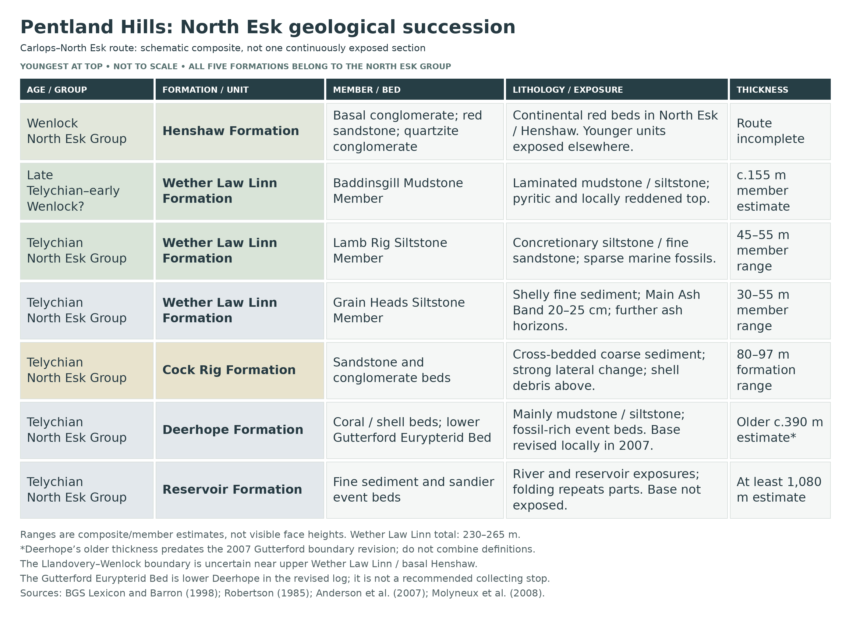
The North Esk Inlier is an area where older Silurian rocks are exposed among younger rocks of the Pentland Hills. Its North Esk Group records a long transition from marine sedimentation to continental red beds. Five formations are recognised, ascending through Reservoir, Deerhope, Cock Rig, Wether Law Linn and Henshaw. They are not five neat horizontal steps on a hillside: the beds have been folded, steepened and locally overturned, and streams expose only parts of the succession between stretches of drift, vegetation and scree.
The sampled fossiliferous marine rocks are principally late Llandovery, especially late Telychian, with the transition towards Wenlock near the upper Wether Law Linn or basal Henshaw succession. This age framework comes from the combined graptolite and palynological evidence, rather than from assigning the entire duration of a stage to each formation. The poorly constrained lowest beds and the exact Llandovery–Wenlock boundary remain less certain. Broad age ranges in formal stratigraphic catalogues are useful context, but do not fix the age of every fossil horizon to a precise date.
Around the reservoir and in the lower river, green-grey to purplish mudstones and siltstones of the Reservoir Formation contain sharper, sandier beds with ripple structures, convoluted lamination and other evidence of moving sediment. Much of the unit is sparsely fossiliferous. Tight and recumbent folds can repeat the beds, which helps explain why its total thickness is difficult to establish. Historical deep-water submarine-fan interpretations have been modified by studies recognising shelf and storm-influenced deposits in parts of the succession. The broad pattern of marine sedimentation and eventual shallowing is secure; a single depositional model should not be applied indiscriminately to every sandstone.
The Deerhope Formation is dominated by finer sediments, with burrowing and thin coarser fossil concentrations recording intervals of seabed activity and sediment reworking. Its coral and shell beds preserve a much richer fauna than many adjoining layers. A significant revision at Gutterford Burn in 2007 placed the local base at the first calcareous sandstone, bringing the limestone and famous Eurypterid Bed into lower Deerhope rather than Reservoir. The exceptional arthropods were preserved in finely laminated, ash-influenced marine claystone. Similar-looking coral or shell layers elsewhere need not be the same bed: repeated environmental conditions can produce comparable deposits at different times.
The coarser Cock Rig sandstones and conglomerates mark an interval of more energetic transport. Cross-bedding, pebbles and shell debris show that grains and skeletal remains were moved and concentrated. The conglomerates change markedly between the North Esk and Deerhope sections, so even a clearly recognisable formation cannot be treated as an identical bed-for-bed stack in every burn. Its mixed pebbles record erosion of several older rock types. The upper shell-rich sandstones pass into the finer Wether Law Linn succession.
Three formal members divide the Wether Law Linn Formation. The lower Grain Heads Siltstone Member contains the most varied shelly assemblages, together with the Main Ash Band and additional thinner ash horizons. The main ash provides a valuable event marker across laterally changing sediments; the lithological boundaries around it are not everywhere the same age. Fossil communities change from brachiopod-rich, burrowed beds to more laminated sediment, then to increasingly mollusc-rich assemblages and renewed transported shell debris. These changes record habitats and preservation as well as geological time.
The middle Lamb Rig Siltstone Member is more sparsely fossiliferous and contains conspicuous calcareous concretions, which help produce rounded weathering forms. Above it, the Baddinsgill Mudstone Member contains laminated and burrowed fine sediment with changing, relatively restricted faunas. Near the North Esk–Henshaw junction, pyritic and locally reddened terminal beds lead into the continental Henshaw Formation. This gradual marine-to-continental transition is distinct from the younger angular unconformity that truncates the folded Silurian rocks.
The route-relevant lower Henshaw succession includes an igneous-clast conglomerate, red micaceous sandstones and a separate quartzite-rich conglomerate in Henshaw Burn. Cross-bedding and pebble concentrations are consistent with stream transport on land. The formation continues elsewhere in the inlier, but the longer Lyne Water succession and its fish bed are not a measured extension of this walking route. Younger rocks overlie the deformed Silurian unconformably; below the reservoir the boundary position can be mapped, although the actual contact is not exposed. Glacial deposits, modern stream sediment and scree further interrupt the view, making careful comparison between outcrops more useful than assuming continuous exposure.
Detailed geology and bed-by-bed succession
Detailed geology and stratigraphy
This account follows the Silurian succession upwards through the North Esk Inlier approached from Carlops: the River North Esk and reservoir, Deerhope Burn, Cock Rig, Wether Law Linn and Henshaw Burn. Gutterford Burn is included for its scientific importance and the evidence it provides for the lower succession; its sensitive fossil beds are not recommended as collecting stops. Published measured sections describe research exposures at particular dates, rather than a continuous section that can all be seen today.
The North Esk Inlier is a window of older, folded rocks surrounded by younger strata. Bedding generally strikes north-east to south-west and youngs towards the north-west or west-north-west, but local overturning, tight folds, small faults and concealed intervals complicate the sequence. Drift, alluvium and scree hide parts of it. Bavelaw Castle and Loganlee are separate Pentland inliers: their inclusion in the wider definition of the North Esk Group does not establish their fossil occurrences or individual beds on this North Esk route.
NORTH ESK GROUP
The five formations, in ascending order, are Reservoir, Deerhope, Cock Rig, Wether Law Linn and Henshaw. The group has a published composite thickness of at least 2,500 m, but its base is unexposed and structural repetition makes simple addition of exposed widths unreliable. It records an overall regression from marine sedimentation to predominantly continental red beds. Older studies interpreted the lower formations as parts of a deep-water submarine fan; later work favours shelf, storm-influenced and offshore-bar settings for important fossiliferous intervals. These interpretations should not be collapsed into one proven origin for every sandstone.
Age and changing definitions. The graptolite and palynological synthesis of Molyneux, Barron and Smith supports principally late Telychian, late Llandovery, ages for the sampled marine succession. In the formation framework used by that study, Reservoir is assigned to the spiralis Biozone, Deerhope spans mid-spiralis to mid-lapworthi, and Wether Law Linn is probably of lapworthi and/or insectus age. The poorly constrained lowest beds should not be given an exact biozone. Early Wenlock evidence for Henshaw comes from spore-bearing exposures elsewhere in the inlier, especially Lynslie Burn; the Llandovery–Wenlock boundary remains uncertain near upper Wether Law Linn or basal Henshaw. The 2008 study did not confirm an older Aeronian assignment for Reservoir, and the Aeronian interpretation repeated in the 2026 review supplies no new sampled evidence to supersede it.
The current BGS Lexicon retains broader unit ranges: North Esk Group, Telychian–Homerian; Reservoir, Deerhope and Cock Rig formations, Telychian; Wether Law Linn Formation, Telychian–Sheinwoodian; and Henshaw Formation, Sheinwoodian–Homerian. These formal ranges are distinguished here from the finer sampled evidence and do not date every exposure precisely. The local Reservoir–Deerhope boundary was revised in 2007, after the definitions underpinning many older maps, logs and thickness estimates. Historical formation heights are therefore retained only in their original source context.
Reservoir Formation
The Reservoir Formation consists principally of green-grey and purple mudstones and siltstones with interbedded sandy siltstone and very fine sandstone. General fossil abundance is low, with exceptional concentrations in particular horizons rather than a uniformly rich succession. The BGS minimum estimate of 1,080 m refers to the North Esk Inlier formation, not one continuous river exposure; its true thickness is uncertain because beds are repeated and cut by small faults.
Lowest river and gorge exposures. Below the reservoir, interbedded siltstone, fine sandstone and laminated shale are tightly to recumbently folded. Robertson’s excursion distinguishes this early folding from later, more open kink folding. Farther downstream, the position of the angular unconformity separating deformed Silurian strata from younger Old Red Sandstone rocks can be mapped, but the contact itself is not exposed. This younger angular unconformity is separate from the conformable formation boundaries within the Silurian sequence.
South-eastern and eastern reservoir-shore beds. Robertson describes individual sandstone and siltstone beds 1 cm to 1 m thick within a roughly 250 m shore section. Barron’s wider formation description records coarser interbeds up to 1.2 m thick. Sharp upper and lower contacts, massive or relatively coarse bases, ripple and convolute lamination and locally burrowed tops record repeated depositional events and fining-upwards beds. Rounded mud clasts and sheets of the enigmatic fossil Dictyocaris occur at the south-eastern reservoir corner; its biological affinity has been debated. Barron’s thin section from this corner contains quartz with abundant detrital muscovite and biotite, minor feldspar and chlorite, and phyllitic and volcanic rock fragments.
Red mudstones and higher northern-shore beds. In the older shore account, the south-eastern siltstones pass across a disturbed interval into fine red mudstone, with occasional sandstone bands higher up. The red mudstone was described as unfossiliferous. Open folding changes the strike along the eastern shore, while the northern shore includes tight fold closures and small faults. These structural changes are important when comparing separated exposures: apparent progress along the shore is not automatically uninterrupted progress up the stratigraphy.
Historical Gutterford subdivisions. The 1962 memoir distinguished basal fine grits and siltstones interbedded with laminated mudstone, the purple Gutterford Burn Mudstones, the Gutterford Burn Flagstones and overlying predominantly argillaceous beds. These are useful historical divisions, not formal members requiring separate coloured bars. The flagstones and lower overlying fine beds supplied many of the early graptolite records. Older accounts placed the Gutterford Limestone, Eurypterid Bed and starfish horizons in Reservoir; the 2007 boundary revision transfers the fossiliferous sequence above the first calcareous sandstone into lower Deerhope. Consequently, the old thickness stack and older undifferentiated crenulata-zone wording cannot be applied unchanged to the revised formation.
Within that historical scheme, the GCR summarises the basal exposed grit–siltstone interval as seen to about 50 m, the Gutterford Burn Mudstones as about 125 m, the Gutterford Burn Flagstones as about 120 m and the succeeding grey-to-olive mudstones as more than 200 m. The mudstone division includes rare flaggy sandstone beds; the flagstone division alternates buff to dark grey coarser beds with grey mudstone and siltstone; the succeeding argillaceous division retains thin flags near its base. These are old, geographically combined estimates with different boundaries from the modern detailed Gutterford log, not a continuous present-day exposure or extra thicknesses to add to the revised formations.
Fairliehope–Gutterford intrusion. A narrow, strongly altered intrusive body is recorded at the north-western reservoir corner and in the Gutterford succession. The excursion describes chloritised sub-basic dioritic rock, baked sedimentary contacts and an exposed width or thickness of about 2–4 m. It records the body as deformed with the Silurian rocks and older than the overlying Old Red Sandstone. This is an intrusion cutting the sedimentary succession, not an additional sedimentary bed or a member of a younger lava formation.
Gutterford local log: 0–3 m micaceous siltstones. The detailed 2007 account is based on about 23 m of strata, using neighbouring lateral exposures where vertical continuity was absent. Its metre values are positions in that local log, not heights above the stream or distances along a path. The overturned bedding places older rocks higher on the slope and younger rocks lower down. The lowest 3 m comprise green-brown micaceous siltstones with thin sandstone ribs, parallel and occasional ripple lamination, muscovite-rich laminae and carbonaceous sheets. Branching Chondrites-type burrows, about 10 mm wide, are concentrated in parts of the first metre.
Gutterford in-situ coral horizon at 2.5 m. Fine green siltstone contains colonies identified in the 2007 study as Favosites multipora preserved in life position, together with lingulid brachiopods, monograptid graptolites, stick bryozoans and a scolecodont. Sparse Glassia occurs in the surrounding micaceous-siltstone unit. This horizon lies below the revised Deerhope base and demonstrates that some corals grew on the sea floor here; it must be distinguished from the transported shell-rich calcareous beds above.
Deerhope Formation
Deerhope is predominantly grey-green, grey-brown, purple and grey laminated or bioturbated mudstone and siltstone, with fossil-concentrating coarser beds. Its type sequence is in Deerhope Burn, with important comparison exposures in the North Esk. The often-quoted 390 m thickness belongs to the older definition used by Robertson and retained in the BGS Lexicon. Anderson and colleagues lowered the local Gutterford boundary in 2007 to the first calcareous sandstone, at 3.00 m in their measured log. Their revision includes calcareous sandstone within lower Deerhope, so an absolute description excluding all sediment coarser than siltstone is no longer appropriate to this revised succession.
Gutterford calcareous sandstone succession, 3.00–12.5 m. Eighteen calcareous beds occur through this 9.5 m local interval, separated by finely laminated green shale that is mostly unfossiliferous. The sandstone beds become thicker upwards and contain shelly lags of brachiopods, bivalves, corals, bryozoans and rare trilobites. They are calcareous sandstones and fossil-rich concentrations rather than eighteen beds of pure limestone. Possible hummocky structures in the 4–5 m interval were interpreted by the authors as evidence for storm influence; this remains an interpretation of subdued structures, not a diagnostic feature of every bed.
Weathered calcareous horizons at 5.2, 7.5, 7.7 and 9.5 m. Each of these recorded levels contains sticky brown clay associated with intense weathering and decalcification of the calcareous succession. Rusty, mouldic textures develop as carbonate is removed, especially towards bed tops and bases. Although volcanic material occurs elsewhere in the section, these four brown-clay horizons should not all be labelled proven primary ash beds.
Gutterford Burn Limestone at 9.90 m. The thickest calcareous bed in the 2007 log is the informally named Gutterford Burn Limestone of earlier accounts. Historical descriptions give about 20–25 cm for this shelly, calcareous-siltstone or sandy-limestone lag. Crinoid ossicles, broken corals and bryozoans, disarticulated brachiopods and bivalves, and less common gastropods, trilobites and ostracods form a concentrated marine assemblage. Its position above the new 3 m boundary places it in lower Deerhope under the 2007 scheme. The named bed is not a separate formal limestone member.
Fossiliferous tops of the calcareous beds. Sheets of Dictyocaris ramsayi, small articulated branching bryozoans and monograptids including Monograptus priodon occur on upper surfaces, interpreted as the ends of fining-upwards depositional cycles. Some black volcanic clasts, 1–2 cm across, are encrusted by bryozoans. The study also reports a conodont identification of Pterospathodus amorphognathoides communicated to the authors; that report is not a precise independent fix on the Llandovery–Wenlock boundary. The calcareous interval ends at the last sandstone at 12.5 m.
Green shale and repeated coral horizons, 12.5–15.4 m. Dark green, massive to locally finely laminated shale succeeds the calcareous sandstone interval. Favosites multipora and Palaeocyclus porpita, as identified in the study, occur at several levels with their calices facing upwards. These are repeated episodes of coral growth, not a single universal coral bed. A separate nodular horizon at about 13.7 m yielded sparse Glassia.
Graptolite flagstones from 15.4 m upwards. Six grey-green micaceous flagstones, typically 10–15 cm thick, alternate with dark green shale in the interval described as 2.5–5.9 m beneath the Eurypterid Bed. They are planar laminated and form resistant ribs; aligned mica, graptolites and sheets of Dictyocaris ramsayi record current influence. Dendroid graptolites, monograptids and Oktavites excentricus occur here, together with small intact starfish and an orthocone. Some individual flags were traced for tens of metres along strike. Lithological comparison places the historical Mirmor andreae material, revised as the octocoral Atractosella andreae, in this interval rather than identifying it as fish armour.
Hard sandstone 1.5 m below the Eurypterid Bed. A particularly hard, “flinty” sandstone contains weathered and decalcified clasts 10–20 mm across, now represented by rusty cavities. The 2007 authors recorded no fossils in this particular bed. Above it, green silts alternate with hard, massive micaceous sandstone before the clay underlying the Eurypterid Bed is reached.
Basal Eurypterid Bed ash. Immediately beneath the fossil-bearing claystone lies about 5 cm of soft, sticky pea-green clay. X-ray diffraction confirmed an altered volcanic ash, or metabentonite, rich in swelling clays. It fills an irregular underlying surface and provides a separate lower boundary marker for the exceptional-preservation unit. This Gutterford ash is much lower in the succession than the Wether Law Linn Main Ash Band.
Eurypterid Bed proper. About 55 cm of very finely laminated light olive-green claystone lies above the basal ash. Its smooth, waxy texture, carbonised arthropod cuticle and locally abundant Dictyocaris distinguish it from the surrounding rocks. Bed thickness varies across the roughly 5 m lateral extent investigated during excavation, and the deposit drapes and fills irregular sea-floor relief. The older GCR account described a 30 cm arthropod-bearing band; that earlier description should not replace the approximately 55 cm whole unit measured in the 2007 investigation. The latter paper places the bed approximately 19 m above the revised Deerhope base; the drawn log is not precise enough to replace that statement with a newly calculated centimetre-level position. Eurypterids, scorpions and other chelicerate arthropods, with articulated echinoderms and associated marine fossils, give the bed its exceptional scientific importance.
Internal and upper Eurypterid Bed horizons. A second thin green clay band occurs 8 cm above the claystone’s base. At 13 cm above the base, a distinct calcareous-rich horizon contains crinoid ossicles, stick bryozoans, monograptids and brachiopods, weathering to a rusty mouldic texture. The authors considered this the likely source of some historical articulated crinoids, rather than proving the bed of origin of every specimen. A third sticky green clay band marks the top of the Eurypterid Bed and drapes its irregular surface.
Post-Eurypterid sandstone and purple siltstone, 21.8–23 m. Lens-shaped, apparently channelised sandstones about 100–150 mm thick overlie the upper clay band. Rusty patches may represent degraded volcanic clasts. Hard blue-purple micaceous siltstone completes the exposed log, with fine lamination on a 3–4 mm scale and occasional sandy lenses. The logged rock sequence ends at the stream-bed exposure; the water-covered part above it in the figure is not an additional measured rock unit.
Preservation and the separate starfish records. Anderson and colleagues interpret the Eurypterid Bed as a normal-marine deposit below storm wave-base, where rapid burial by fine, ash-influenced sediment favoured exceptional preservation. Their investigation found starfish in micaceous siltstone, calcareous beds, graptolite flags and the Eurypterid Bed itself, so no single horizon could uniquely be called the Starfish Bed within their measured section. Older memoirs and excursions separately record two starfish-bearing horizons farther along Gutterford. Those historical records must not be merged into one exclusive marker or assumed to be the same exposed lens as the Eurypterid Bed.
Historical lower starfish horizon. The 1962 memoir describes a roughly 2 mm band of buff siltstone within grey mudstone and siltstone, near the base of the old post-flagstone argillaceous division. It records starfish under the identification Furcaster leptosoma, with sparse accompanying shelly fossils, and describes their preservation as poorer than at the classical upper locality. This is a source-specific historical horizon, not a newly located bed in the 2007 Eurypterid Bed excavation.
Historical upper starfish horizon. The classical higher locality is described in the memoir and excursion as fine micaceous silty shale with a diverse asteroid fauna and relatively sparse brachiopods and other shells. The older accounts include Crepidosoma wenlocki among the recorded starfish. Its significance rests on historical collections and stratigraphic descriptions; the named locality does not establish a single starfish-only bed through the entire Gutterford succession.
The Gutterford coral-bearing sequence and the Deerhope Coral Beds share environmental features, but the 2007 study expressly does not require them to be the same laterally continuous bed: similar conditions recurred at different times. A projected continuation of the Gutterford fossiliferous sequence towards the northern reservoir shore was not confirmed by detailed logging. An isolated starfish-bearing loose slab from the eastern shore likewise does not establish an in-situ correlated horizon.
Separate R199 starfish-bed investigation, 2008. Donovan and colleagues described two trenches through near-vertical beds striking about 020°. Units 1, 3, 5 and 7 were massive to weakly laminated siltstone and sandstone, alternating with grey-clay units 2, 4 and 6 interpreted as weathered bentonite. Neither section limit was exposed. Even targeted examination below the clays yielded only half a brachiopod valve. The authors suggested depletion of a small channel-fill lens, while considering possible mislocation; this did not establish exhaustion of all starfish horizons. These seven units belong to the separate lower-starfish-bed investigation, not the 2007 Eurypterid Bed log. No individual thicknesses are reconstructed here.
Deerhope Burn type succession and Coral Beds. Robertson’s original Deerhope section progresses from mudstone and shale with fine silty laminae into micaceous-siltstone beds about 0.10–0.15 m thick. Bioturbation is common, and shelly faunas become more varied upwards. Several thin fossil-concentrating siltstones in a side-stream are collectively termed the Deerhope Coral Bed or Coral Beds. They contain corals, crinoid debris, brachiopods, bivalves, bryozoans and trilobites; the name does not imply a massive coral reef. The modern brachiopod Isorthis (Ovalella) clarksoni is directly documented here, including the holotype NMS G.2006.40.18.
Coral Bed and higher North Esk bivalve horizon: separate historical positions. Robertson’s 1985 log places the Deerhope Coral Bed at outcrop R247, approximately 265 m up his original 390 m formation. His North Esk comparison places Lamont’s bivalve locality, R55, higher, around 300 m on that same historical scale. These are different fossil concentrations, not one coral bed simply traced across the valley. Neither numerical height should be read as a measurement above the revised 2007 Deerhope base.
Upper Deerhope shell-lag siltstones. The North Esk section contains thin siltstone beds, commonly 5–10 cm in the excursion account, with fossils concentrated at their bases. Bivalves, gastropods, brachiopods, corals, trilobite remains and crinoid or other pelmatozoan debris occur in these lags. Tool marks and lineations record currents broadly from the east, with erosion of cohesive sediment surfaces. Barron’s thin-section study supports primary sedimentary lamination and ripple-like structures rather than the older suggestion that every corrugated surface was produced by tectonic shearing. This is upper Deerhope, despite an inconsistent reference to Cock Rig within the older excursion’s locality description.
R55 in the 2011 crinoid study. Donovan and colleagues separately describe a roughly 12 m-long exposure with vertical bedding striking about 020°. Their account emphasises medium-grained grey sandstone, in 5–100 mm beds with millimetre-scale lamination, and rare purple siltstone. Crinoid-bearing samples came from loose material at its north-western end, not directly from a measured bed. This later sandstone description is retained alongside the older upper-Deerhope siltstone account; neither is silently substituted for the other.
Cock Rig Formation
The Cock Rig Formation, historically the Haggis Grit and Conglomerate and included in Tipper’s older Deerhope Formation, marks a conspicuous change to medium- and coarse-grained sandstone with conglomerate and thin mudstone partings. The base is the first coarse sandstone above Deerhope fine sediment; the upper boundary is the change from the highest sandstone to green-grey Wether Law Linn mudstone. The BGS formation range is 80–97 m, with 97 m in Robertson’s original measurement, rather than the height of a single quarry face. The North Esk riverbanks and old quarries and the Deerhope Burn expose different parts and lateral expressions of this interval.
North Esk sandstone and conglomerate beds. Robertson recorded at least fourteen conglomerate beds, mostly about 0.25 m thick with clasts up to 50 mm across, interspersed with sandstone beds 0.1–1 m thick. The conglomerates are clast-supported and poorly sorted or graded, with both fining- and coarsening-upwards intervals. Granite, porphyritic and volcanic rocks, quartzite, chert and fine sedimentary rocks contribute to the mixed clast assemblage. Low-angle cross-bedding, about 5–15° in his measured examples, shows reworking and varied flow directions; basal load structures and tool-marked surfaces are also recorded. These are historical measured observations, not fourteen separately named beds guaranteed to be countable in a present quarry exposure.
South-westward change and the upper sandstone. In Robertson’s Deerhope comparison, only four grit horizons about 0.15 m thick remained, with clasts up to about 15 mm. This strong lateral reduction explains why the river and burn cannot be combined into one invariant stack. Shale interbeds reach about 0.25 m in the original description. Towards the top, low-amplitude symmetrical ripples were recorded at Deerhope R260, while the North Esk upper sandstone at R79 shows trough cross-bedding.
Upper Cock Rig transported shell horizons. Most of the sandstone and conglomerate is sparsely fossiliferous and carries broken or disarticulated material, but shell concentrations increase towards the highest sandstone. Brachiopods, bivalves and pelmatozoan debris, including crinoid ossicles, form transported assemblages. The association formerly named for Isorthis mackenziei is now termed the Isorthis clarksoni–pelmatozoan association following the revised brachiopod work. It is an ecological and sedimentary association, not a time-zone. The older submarine-fan feeder-channel interpretation differs from later offshore-bar and nearshore models.
Wether Law Linn Formation
Green-grey bioturbated mudstone above the Cock Rig sandstone marks the base of this fossiliferous marine formation. Its published 230–265 m thickness is a composite formation range, assembled from discontinuous exposures and allowing for lateral change. The formal ascending members are Grain Heads Siltstone, Lamb Rig Siltstone and Baddinsgill Mudstone. These correspond respectively to Robertson’s Lower, Middle and Upper members. Tipper’s informal units a–c form Grain Heads, unit d corresponds to Lamb Rig and unit e to Baddinsgill. His a–e scheme, also lettered A–E in his figure, is different from the nineteenth-century lettered fossil localities and from Robertson’s numbered sampling intervals.
Grain Heads Siltstone Member
The former Lower Member contains green-grey and olive silty mudstone, siltstone and fine sandstone, with both laminated and strongly burrowed intervals. Fossils are especially concentrated towards its base and top. Robertson gave a 30–55 m member thickness, a range also retained in the current BGS Lexicon. His type exposure is Wether Law Linn R265, with North Esk R82–R83 and Deerhope R260 as important comparisons. The base is bioturbated green-grey mudstone over Cock Rig sandstone; the top is the highest laminated sandy siltstone or fine sandstone rich in shell debris, recorded at R83. These member boundaries and thicknesses should not be confused with the shorter sampled profiles described below.
Pre-ash unit a. Tipper describes brown fossiliferous siltstone with abundant Skenidioides and Dicoelosia, beginning above the highest mica-enriched sandstone of his older Deerhope Formation, which then included the later-separated Cock Rig unit. The upper boundary is the Main Ash Band. The unit thins and wedges south-westwards, and its basal lithological boundary is diachronous: the same change in sediment type occurred at different times in different places. Robertson’s composite account characterises the pre-ash interval as heavily bioturbated, relatively slowly accumulated sediment with the Skenidioides lewisii–Cyrtia exporrecta association. It is not a uniform thickness of identical beds beneath the ash at every exposure.
Main Ash Band, unit b. Tipper’s primary description gives 20–25 cm true thickness for this essentially unfossiliferous white altered ash. Apparent local thickening to about 40 cm resulted from clay entering joints, particularly in disturbed or slumped exposures. Robertson’s approximately 0.2–0.25 m descriptions are compatible with that measurement, whereas Barron described a particular surviving Wether Law Linn exposure only up to 15 cm thick. These are distinct measurements and exposure conditions, not values to average. Barron reports the later geochemical interpretation of a rhyodacitic parent ash. The band is a metabentonite and a useful time-marker, and its depositional interval coincides with a marked faunal change.
Basal mineral-rich 5 mm of the Main Ash Band. In Tipper’s petrographic description, this thin basal layer contains about 60% degraded feldspar and 35% biotite, with little quartz and apparently no carbonate. It is a mineral-rich part of the same ash bed, not a separately named stratigraphic unit. Its composition contrasts with the clay-rich material above.
Upper clay-rich part of the Main Ash Band. Most of the remaining bed is illitic clay with subsidiary quartz, chlorite and feldspar. Calcite occurs through the clay and as crystalline plates up to 10 cm long and 2 cm thick; Tipper identified the plates as diagenetic growths and considered the disseminated calcite probably diagenetic too. Biotite dominates the heavy-mineral fraction. Excluding biotite, the described heavy-mineral suite is approximately 95% apatite and 5% zircon, with traces of garnet and opaque minerals. Euhedral apatite prisms reach about 50 μm long, with a mean around 25 μm; their form and the restricted mineral suite supported an ash origin. These mineral proportions refer to particular fractions in the historic analysis, not percentages of the whole bed, and the crystal dimensions are analytical observations rather than extra beds.
Basal post-ash beds, unit c. The basal interval above the Main Ash Band corresponds to the historical “Plectodonta mudstones”. It passes upwards into well-stratified flaggy siltstone. Robertson describes laminated fine sandy siltstone with an Eoplectodonta penkillensis-dominated assemblage, contrasting with the diverse pre-ash association. The ash provides an approximately synchronous lower datum, while the upper boundary of unit c is a change to poorly stratified mudstone and is controlled by changing sedimentary facies. Tipper records the unit thinning north-eastwards. The faunal turnover is real, but it does not prove that one ashfall exterminated every species or that every Eoplectodonta specimen belongs above this bed.
Two additional ash horizons within unit c. Tipper records two further volcanic-ash bands in the post-Main-Ash succession. They are distinct additional horizons within unit c, not simply repeated names for the Main Ash Band. The inspected unit description does not provide secure individual thicknesses or exact metre positions for them, so no numbered, uniformly spaced ash sequence can be reconstructed from it.
Other white-clay laminae in unit c. Several thinner white-clay laminae were also noted by Tipper and considered possibly volcanic. Their origin was less firmly established than that of the named ash bands. Robertson likewise records thin white-clay bands at several outcrops in the broader succession. A pale parting alone therefore neither proves an ashfall nor identifies the Main Ash Band.
Higher mollusc-rich siltstone and silty mudstone. Above the strongly Eoplectodonta-dominated interval, less clearly laminated sandy siltstone and silty mudstone contain the association historically termed Liospira(?)–Synek(?). The North Esk sampled profile particularly represents this higher post-ash interval. The excursion describes an upwards increase in gastropods, including Gyronema salteri, and bivalves and lingulid brachiopods, while several earlier abundant brachiopod and trilobite components become less numerous. The old questioned generic assignments are retained as association labels, not silently converted into a fully revised species checklist.
Upper Grain Heads bioclastic beds. Laminated siltstone and fine sandstone towards the member top again contain transported brachiopod and pelmatozoan debris. These are the upper recurrence of the Isorthis clarksoni–pelmatozoan association, formerly named for I. mackenziei, also recorded in upper Cock Rig. Stronger lamination and local shell lags distinguish them from the intervening muddier, mollusc-rich deposits. This recurrence is a change in facies and fossil association, not evidence that the beds are the same age or that one fossil group is confined to a single narrow level.
Comparing the lower-member logs. Robertson’s composite lithological column summarises observations from different sections. His comparative figure aligns separate logs on the Main Ash Band, labelled T, deliberately offsetting their bases. The approximately 12 m position of T on the shared drawing scale is an alignment datum, not a demonstrated height 12 m above the formation base everywhere. Wether Law Linn has a thicker pre-ash interval than Deerhope, while the sampled North Esk section mainly covers higher post-ash beds. The ash is useful precisely because the surrounding facies boundaries and thicknesses vary laterally.
North Esk R82–R83 sampled profile. Robertson divided this research profile into numbered sample intervals: 1–5 at 0.5 m each, 6–45 at 0.25 m and 46–76 at 0.5 m. Their nominal sum is 28 m of sampled rock, not a complete 55 m member or 76 natural beds. The original plan shows an exposure gap between R82 and R83; its graphical connection does not establish uninterrupted outcrop. Bedding is recorded with strike 045° and vertical dip. The Main Ash Band is not drawn within this sampled river profile, which chiefly represents the higher post-ash succession.
Wether Law Linn R265 sampled profile. This separate profile comprises 49 intervals of 0.5 m, giving a nominal 24.5 m of sampled rock. The recorded strike is 065° and dip 50° south; the locally overturned succession requires attention to younging rather than treating upward on the hillside as younger. In the original drawing the Main Ash Band lies near the boundary between sample intervals 18 and 19, approximately 9 m from the sampled profile’s start. That is an approximate reading of this particular sampling diagram, not a surveyed universal height above the formation base.
Deerhope R260 sampled profile. The 83 intervals of 0.5 m give a nominal 41.5 m of sampled rock and include upper Cock Rig as well as lower Wether Law Linn. Bedding strikes 050° and is vertical. Several separately exposed sampling runs are connected by dashed gaps in the plan, so the summed sample thickness is not a continuous natural rock face. The Main Ash Band is marked low in the sequence near sample intervals 17–18. Those sample numbers must not be mistaken for formal bed numbers, and the scan does not justify centimetre precision for its position.
What the abundance profiles measure. Robertson’s fossil curves compare selected sampled blocks, not every organism present in the member. His principal chart key includes fifty categories occurring in at least 5% of blocks in at least one assemblage; some rarer or fragmentary groups were excluded. The Wether Law Linn R265 profile and lower-numbered Deerhope R260 samples 1–33 draw on Tipper’s earlier material, and some original specimens were unavailable for renewed identification. Here “Deerhope” identifies the sampling place, not the Deerhope Formation. A taxon labelled “not identified” in a profile is not demonstrably absent from the rock. These limitations matter when comparing the three sampling schemes.
Lamb Rig Siltstone Member
The former Middle Member corresponds to Tipper’s unit d. Robertson’s 45–55 m estimate is retained in the BGS Lexicon, but this is a member thickness rather than the size of one burn-side face. The type exposure is Wether Law Linn R266, with North Esk R83–R87 and Deerhope R261 as comparisons. The base succeeds the bioclast-rich upper Grain Heads beds; the top lies beneath the first olive-grey silty mudstone of Baddinsgill. Tipper regarded unit d as apparently diachronous, with sandy siltstone and mudstone whose weak stratification may partly reflect homogenisation by burrowing.
Lower laminated and higher concretionary beds. The lower Lamb Rig beds are olive-yellow siltstones with distinct olive-brown sandstone laminae. Higher olive and yellow-brown micaceous siltstone and fine sandstone have less persistent lamination, relatively common bioturbation and occasional isolated pebbles or mud clasts. Well-developed calcareous concretions obscure some sedimentary structures and produce conspicuous spheroidal weathering. Fossils are sparse compared with Grain Heads, but unbroken, disarticulated brachiopods, orthocones and dendroid graptolite remains are documented. “Poorly fossiliferous” is therefore more accurate than “barren”.
Baddinsgill Mudstone Member
The former Upper Member corresponds to Tipper’s unit e and is also spelt Baddingsgill in some publications. Robertson’s approximately 155 m succession, retained as the BGS member estimate, is represented by North Esk and Henshaw outcrops R87–R105. Its lower boundary is the first olive-grey silty mudstone, although this is difficult to place exactly in the field. Basal grey mudstones with thin planar olive laminae alternate with indistinct muddy-siltstone beds about 0.10–0.15 m thick. Higher beds are grey, olive-grey and brown micaceous shale with fine silty laminae; the siltier intervals are commonly bioturbated. Tipper’s earlier description emphasised well-laminated brown siltstone with fossils identified as Entomis, Pentlandella and Platyschisma, and acknowledged that the lower boundary of his unit e was unexposed. He regarded the unit as apparently diachronous, with its upper boundary immediately beneath the first Henshaw red beds.
Changing upper-member fossil assemblages. The North Esk–Henshaw beds contain well-preserved but unevenly distributed fossils, often with a few dominant forms at each level. Robertson’s excursion describes successive assemblages characterised by a nuculoid bivalve recorded there as Praearca kosoviensis, then a gastropod called Spirina antiquata, the brachiopod Pentlandella pentlandica, and higher gastropod-rich beds recorded as Liospira(?) simulans. These are historical identifications and successive local assemblage descriptions, not four formal members or modern biozones. The 1985 outcrop-range chart uses some different determinations, including Praenucula thracoides; its outcrop axis cannot be read as a metre-scale log or assumed to resolve every later taxonomic change.
Outcrop-scale range and provenance. Robertson’s R87–R105 chart records Dictyocaris and cephalopods through much of the upper member, with more restricted occurrences of brachiopods, gastropods, nuculoid bivalves, trilobites, ostracods, Ceratiocaris, pelmatozoans and machaeridian plates. Candela and Crighton’s later specimen audit identifies historical material probably from R98 as Platyschisma simulans, documents the trilobite Scotoharpes domina from Henshaw Burn in Wether Law Linn strata, and discusses confirmed Phragmoceras ventricosum material from R101. Such specimen-level evidence does not automatically revise every fossil in the older abundance curves. Henshaw Burn is a place name, not proof that a fossil came from the Henshaw Formation.
Pyritic siltstone and reddened shale at R105. Near the top of the member, olive-brown rusty siltstone and silty mudstone contain weathered pyrite cubes and manganese dendrites along bedding surfaces. The dendrites are mineral growths, not plant fossils. These beds pass upwards into soft red shale whose fossils carry black iron and manganese coatings. Thin bedding-parallel white lenses contain quartz, potassium feldspar, white mica and kaolinite. Robertson’s several-metre local transition records chemical alteration and redistribution of minerals; he explicitly states that the red-shale passage is absent from other exposures of the equivalent level.
Terminal 6 cm clay and the Henshaw contact. At R105 a light blue-grey clay bed, 6 cm thick, lies directly below the first Henshaw grit. It is separate from the much lower Grain Heads Main Ash Band, and a volcanic origin for this contact clay is not established by the description. The highest poorly lithified red shale is overlain by pebbly grit containing 5–10 cm layers of sand grains and pebbles with black iron and manganese coatings; these coated layers become fewer and less persistent upwards. The lithological boundary is conformable and records the passage towards continental deposition. It is not the younger angular unconformity, nor a precisely demonstrated Llandovery–Wenlock time-boundary.
Henshaw Formation
Red sandstone and conglomerate overlying Wether Law Linn record the establishment of predominantly continental conditions. The formation-wide minimum thickness is 725 m, and its full type succession extends through the Baddinsgill–Lyne Water area. Only part is represented by the North Esk and Henshaw Burn reference exposures. The formal BGS age range is Sheinwoodian–Homerian, within the Wenlock, while the lower succession has early Wenlock support from regional spore evidence. Broad alluvial-fan and river interpretations apply to the continental succession; minor marine influence recorded elsewhere in the formation should not be treated as proof of a marine fossil bed at every Henshaw exposure.
Igneous Conglomerate, informal Unit 1. North Esk exposures include red, clast-supported conglomerate, poorly bedded or arranged in beds up to about 1 m thick. Barron’s composite unit estimate is about 35 m, rather than the height of one river face. Rounded to subrounded cobbles and boulders reach about 0.3 m and include granite, microgranite, quartz-feldspar porphyry, felsic lava, altered sub-basic lava, chert, quartzite and fine-grained sedimentary rocks. Thin-section evidence from the river confirms abundant igneous fragments, including granophyric granite and texturally varied felsite. This Silurian conglomerate is distinct from the younger Greywacke Conglomerate Formation above the angular unconformity.
Lower red sandstone, informal Unit 2. The overlying red micaceous sandstones range from fine to coarse grained, with quartz-granule lenses, pebble strings and mud clasts. Barron’s formation-scale account gives beds commonly 0.1–0.5 m thick within a composite interval of about 250 m. North Esk exposures above the conglomerate contain medium-grained sandstone with occasional trough cross-bedding, recording current transport. The large unexposed gaps in the historical North Esk column prevent these estimates being presented as a continuously accessible 250 m section.
Quartzite Conglomerate in Henshaw Burn. Near the upper part of the lower red-sandstone interval, a distinctive conglomerate is about 1.5 m thick in the Henshaw Burn descriptions of the memoir, excursion and Barron. The excursion estimates roughly 70% quartzite clasts; Barron describes rounded to subrounded pebbles and cobbles, including haematite-veined white quartzite and occasional igneous and fine-grained sedimentary clasts. The 1962 account places the roughly 5 ft conglomerate above about 3 ft 4 in of laminated mudstone and siltstone at this local occurrence. Its composition contrasts with the lower Igneous Conglomerate. A GCR account quotes 7.5 m for a quartzite-conglomerate exposure in the North Esk River; this different reported exposure and measurement should not replace the supported 1.5 m Henshaw value.
Limit of the North Esk–Henshaw record. Robertson’s original North Esk R105–R112 column shows separated conglomerate and sandstone outcrops, large gaps and an uncertain upper limit. His longer comparison column for Baddinsgill and Lyne Water carries the Lyne Water Fish Bed marker; that marker is absent from the North Esk column. The detailed higher Henshaw Units 3–6 and fish-bearing Lyne Water–Lynslie succession therefore belong to a different part of the inlier and are not transferred into this route’s bed log or advertised as Henshaw Burn fish-finding horizons.
References
British Geological Survey. BGS Lexicon of Named Rock Units: North Esk Group; Reservoir, Deerhope, Cock Rig, Wether Law Linn and Henshaw formations; Grain Heads Siltstone, Lamb Rig Siltstone and Baddinsgill Mudstone members. Records accessed 13 October 2026.
Barron, H. F. (1998). Geology of the central Pentland Hills. British Geological Survey Technical Report WA/98/41, particularly pp. 4–9 and Table 2.
Robertson, G. (1985). Palaeoenvironmental interpretation of the Silurian rocks of the Pentland Hills. PhD thesis, University of Edinburgh, particularly the measured sections, sampling profiles and palaeoecological comparisons in Chapters 2, 4, 5 and 10.
Tipper, J. C. (1973). The marine Silurian of the North Esk Inlier. PhD thesis, University of Edinburgh, particularly pp. 41–44 and Figures 13, 16 and 17.
Donovan, S. K., Fearnhead, F. E., Clarkson, E. N. K. & Donovan, M. (2011). Aspects of crinoid palaeontology of the North Esk Inlier, Scotland (Silurian, Llandovery, Telychian). Palaeontology 54, 241–252.
Anderson, L. I., Clarkson, E. N. K., Stewart, S. E. & Mitchell, D. (2007). An Upper Llandovery Konservat-Lagerstätte in a depositional context: the Pentland Hills Eurypterid Bed, Midlothian. Scottish Journal of Geology 43(1), 41–50.
Molyneux, S. G., Barron, H. F. & Smith, R. A. (2008). Upper Llandovery–Wenlock (Silurian) palynology of the Pentland Hills inliers, Midland Valley of Scotland. Scottish Journal of Geology 44(2), 151–168. Accepted manuscript.
Candela, Y. & Crighton, W. R. B. (2019). Synoptic revision of the Silurian fauna from the Pentland Hills, Scotland described by Lamont (1978). Palaeontologia Electronica 22.2.19A, 1–45.
Harper, D. A. T., Candela, Y. & Gallagher, E. E. (published online 2026; issue dated 2025). The Pentlandian: fact or fiction? Earth and Environmental Science Transactions of the Royal Society of Edinburgh 116, 185–197.
Robertson, G. (1996, Earthwise-hosted edition). North Esk Inlier: River North Esk and Gutterford Burn. In McAdam, A. D. & Clarkson, E. N. K. (eds), Lothian geology: an excursion guide.
Aldridge, R. J., Siveter, David J., Siveter, Derek J., Lane, P. D., Palmer, D. & Woodcock, N. H. (2000). British Silurian Stratigraphy. Geological Conservation Review Series 19. JNCC, Peterborough. Gutterford Burn, pp. 173–176; Lyne Water and Lynslie Burn, pp. 319–323.
Mitchell, G. H. & Mykura, W. (1962). The geology of the neighbourhood of Edinburgh. Third edition, Memoirs of the Geological Survey of Great Britain, Scotland, Sheet 32. Silurian chapter by Mykura and Smith.
Safety
The fossil exposures require more effort and judgement than the main walk to North Esk Reservoir. Steep grassy slopes, loose scree, slippery rock, overgrown ground and awkward burn crossings can make short distances slow. Stay away from unstable quarry faces and undercut banks, do not enter the reservoir, and turn back rather than wade a hazardous crossing. Choose exposures that can be viewed from secure ground.
Avoid burn exploration during or after heavy rain, in high water, or when snow and ice make the ground unsafe. Hill weather can change quickly and full winter conditions are possible. Go with someone experienced, tell another person your route and expected return, and allow enough daylight for the walk back. Carry a charged phone, but do not depend on a signal or a phone alone for navigation. In an emergency call 999, ask for Police/Mountain Rescue and give your grid reference.
Equipment
Take sturdy walking boots, a suitable map and compass, waterproofs, warm layers, food, water, a first-aid kit, torch and emergency shelter. A hand lens, camera, notebook and small scale are the most useful fossil-observation tools. Insect repellent can help in midge conditions. Leave gates as found, give livestock space and take all litter home.
If collecting has been specifically authorised, take tissue or paper and rigid containers so that fragile pieces can be wrapped individually. Keep matching parts together and label them immediately. A pick or trowel is not a default part of this visit: do not excavate banks, ash beds or protected fossil horizons, and do not use tools beyond the permission and consent actually obtained.
Cleaning And Treating
For authorised finds, begin with the least preparation possible. Weathered mudstone and siltstone can crumble, and a fossil may survive as a thin film or a delicate mould rather than solid shell. Let wet pieces dry slowly at room temperature and test a soft, dry brush on an unimportant area. Do not soak friable matrix or force a split through a fossil-bearing surface. Photograph the piece before and after any work and keep loose flakes with it.
Avoid household acids, bleach, oil and varnish. Harder calcareous pieces may need careful mechanical preparation under magnification, but force can remove the fossil along with the rock. Leave unusual or potentially important material unprepared and seek museum or specialist advice; preservation of its original context and surface is more valuable than a heavily cleaned display specimen.
Identify Your Finds
Need help identifying a fossil? Share clear photos, where you found it and its size with the community.
Further Reading
Deposits: review of Silurian Fossils of the Pentland Hills, Scotland
BGS Earthwise: River North Esk geological excursion, with historical exposure descriptions
BGS: Geology of the central Pentland Hills
BGS Lexicon: North Esk Group
Anderson and colleagues: the Eurypterid Bed in its depositional context
Molyneux and colleagues: palynology and the age of the Pentland succession
Candela and Crighton: revision of Lamont’s Silurian fauna
Harper, Candela and Gallagher: The Pentlandian: fact or fiction?
Access Rights
Parts of the North Esk valley, including Gutterford Burn and part of the reservoir, lie within North Esk Valley SSSI. The designation covers defined areas, not the whole Pentland Hills. Check the official boundary and current notices when planning a visit. Gutterford Burn is not recommended as a collecting stop in this guide because of its sensitive, scientifically important fossil horizons.
Walking access does not give permission to remove fossils. Obtain the landowner’s permission and check any separate mineral ownership before taking specimens, including loose finds. Within the SSSI, establish with the landowner or occupier and NatureScot what consent the proposed activity requires. Ground outside the SSSI is not automatically free for collecting. Do not hammer or excavate the protected exposures; if permission or consent is unclear, photograph finds and leave them in place. Follow the Scottish Fossil Code and respect current site notices.
 Scotland’s fossil resource is at risk of abuse and damage, and so we must all safeguard and managed fossil collecting to ensure its survival for future generations. For this reason it is VITAL you read and adhere to the Scottish Fossil Code for ALL sites in Scotland.
It is important to follow our ‘Code of Conduct’ when collecting fossils or visiting any site. Please also read our ‘Terms and Conditions‘
Links
♦ Fossil Discussions
♦ Fossil Articles
♦ Buy Fossils, Tools and Equipment
♦ Buy Crystals, Meteorites, and Artefacts
♦ Join Fossil Hunts
♦ UK Fossils Network


